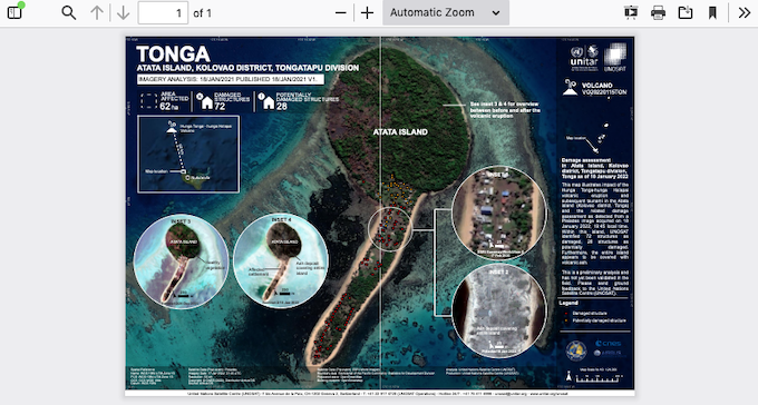
New images appear to show the majority of structures on the Tongan island of Atatā have been wiped out after a volcanic eruption and tsunami last weekend.
The Tongan government has so far confirmed three deaths from Saturday’s eruption of Hunga Tonga-Hunga Ha’apai, and all houses on the island of Mango were also wiped out.
The New Zealand Defence Force has described the damage to the island of Atatā as “catastrophic” in its surveillance photo, which was posted online by a resort based there.
- READ MORE: Tongan government confirms all homes on Mango destroyed, fears death toll of 3 may rise
- Scientists warn Tonga eruption may damage environment for years
- Gallery: What the NZ air crew saw at Tonga’s Nomuka – a choking carpet of volcanic ash
- Other Asia Pacific Report coverage of Tonga
The United Nations Institute for Training and Research (UNITAR) also released an image of Atatā island on January 18, with an assessment that 72 structures had been damaged and the entire island covered in ash.

However, it noted it was a preliminary analysis and had not yet been validated on the ground.
The Royal Sunset Island resort posted on Facebook that all residents had now been evacuated to the mainland.
The resort was fully submerged by the tsunami and it was not expected there would be much left.
Other satellite imagery circulating online also appeared to show major damage on the island.
Meanwhile, the New Zealand government today announced two naval ships with supplies had been approved for arrival in Tonga.
The ships were sent before an official request for help from the Tongan government, but the statement from Minister of Foreign Affairs Nanaia Mahuta’s office this afternoon confirmed the vessels — expected to arrive by Friday, depending on weather — had been approved.
So hard to tell what’s going on here at the Vakaloa Beach Resort… maybe this is just completely covered in ash. You can see the outline of the wall on the left, and a line along the sand where the building is/was… could conceivably be completely covered in ash. pic.twitter.com/F3ZRwAkmTr
— AI6YR (@ai6yrham) January 17, 2022
The eruption was likely the world’s largest in the past three decades, and support and aid efforts have been stymied by communications outages after the blast.
US company SubCom expected repairs to the undersea cable, which carries most of Tonga’s communications, would take at least four weeks.
A mobile network was expected to be established using the University of South Pacific’s satellite dish today, though the connection would likely be limited and patchy.
Volcanic activity and tsunami risk continues to be monitored.
This article is republished under a community partnership agreement with RNZ.
This post was originally published on Asia Pacific Report.