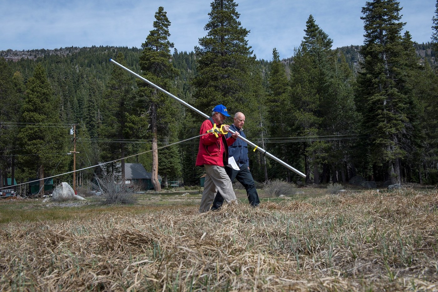
David Haakenson thinks about water a lot. That’s because the farm he owns in western Washington experiences frequent, catastrophic floods. And climate change is making that trend worse.
“We had floods in October. We had floods in November, December, January, February, and March,” said Haakenson, the owner of Jubilee Farm. “There’s this kind of anxiety that involves — like, when you look out on the field and say, ‘Wow, I make my living off that field and now it’s a lake.’”
To protect Jubilee Farm, Haakenson is looking to an unlikely ally: Beavers. Because it turns out, beavers might actually offer some real protection against climate impacts like flooding and wildfires — if people can learn to live with them.
Farmers and beavers don’t often get along. Even Haakenson has had his share of conflicts with the local family of beavers who regularly turn his field into what he calls “Lake Jubilee.”
“The beavers have their goal in life and I have my goal in life,” Haakenson said. “My job is to farm and there is some friction there. But if I were to remove the beavers, more beavers would just come over because it is like a beaver paradise.”
Beavers have lived in North America for more than 7 million years. Until recently, the United States was home to a staggering number of them: Somewhere between 60 million and 400 million. That means for millions of years, North America looked completely different. It was a country covered in swamps, from the Arctic Circle to the deserts of the U.S. Southwest.
But by the end of the 1800s, everything had changed. Fur trappers hunted beavers to near extinction – and without them, American ecosystems completely changed. So when most of modern America was built, beavers weren’t really on anyone’s radar.
“It was all without beavers in mind. Without thinking about how they could affect our infrastructure, our roads, our yards, our driveways, our homes, our farms,” said Jen Vanderhoof, a senior ecologist for King County in Washington state. “They weren’t here. And we didn’t have to think about them.”
But in the last few decades, beaver populations have started to rebound — only to a fraction of their previous levels, but enough to cause trouble when they flood properties, wash away roads, or chew up trees.
“People are always like, ‘We didn’t used to have beaver problems,’ or ‘We didn’t used to have beavers and never saw beavers here before,’” said Vanderhoof. “But things are changing and they’re not going away at this point.”
“A lot of people get kind of irate about beaver dams, because beavers have one joy in life: and that is stopping water,” said Haakenson. “They probably have other ones. I’m sure they lead rich inner lives. But they really like stopping water from flowing.”
Now, as rising global temperatures make rainstorms more intense and frequent, Haakenson thinks that beavers’ ability to stop water might be able to actually help his farm.
To understand how that might work, let’s take a trip to a hypothetical creek. Like a lot of creeks, it’s just a single narrow channel. During winter storms, water rushes downstream. During summer, the creek dries up to a trickle. Climate change is making those floods and droughts even more extreme.
But here’s what happens if a beaver moves in: The beaver builds a dam, and water starts to back up into a pond. During a flood, a lot of that water can get stored in the pond, and in the soil underneath the pond, where it permeates through the ground and eventually comes out downstream. During summer droughts, when everything on the surface is usually dried up, there’s still water stored in the ground under the beaver pond, creating a lush oasis in an otherwise dry landscape.
An oasis that can even stand up to wildfire. One recent study looked at five streams that were hit by wildfires, comparing damage in areas with and without beaver dams. In every single case, the stream sections with beaver dams experienced only a third of the fire damage. All this matters, because climate change is contributing to more severe droughts, fires, and flooding, and beavers can help communities with those problems, just by doing what they do.
Take the Snoqualmie River, which regularly floods David Haakenson’s farm. It starts high in the Cascade Mountains, fed largely by melting alpine snow. But a warming climate is changing that. Storms are starting to deliver less snow and more rain — rain that rushes downstream during storms, and floods the river valley below. And flooding in the valley is probably only going to get worse.
“I feel like it’s going to be the thing that eventually the farm will go under because of – flood water,” Haakenson said. “The flooding is getting worse. The beavers might actually be able to help with that.”
One study estimated that on the Snoqualmie River, more beaver dams upstream could help store over 6,000 Olympic swimming pools worth of water.
On his farm, Haakenson keeps an eye on the dam, trying to keep it from overtaking his field. But beyond that, he pretty much lets the beavers do their thing.
“There’s kind of two ways to approach nature, and one is to fight it and the other one is to try to figure out how to coexist,” Haakenson said.
As beaver populations return, more people are following that strategy: Using tools like pond levelers or fences to protect the things that matter to them, but also letting beavers be when they’re not hurting anyone.
Americans are used to a world without beavers, but that’s changing, whether we like it or not.
Sure, beavers can be frustrating. But if we can learn to get along with these giant aquatic rodents, they might even turn out to be helpful neighbors.
This storywas originally published by Hakai Magazine and is reproduced here as part of theClimate Deskcollaboration.
In the next few years, Indonesia will start moving its capital city from one island, Java, to another, Kalimantan, the Indonesian part of Borneo. There are a few reasons for the move, but one of the biggest is that the country’s current capital, Jakarta, is sinking at an alarming rate. By the middle of this century, one-third of the city will be underwater.
It would be easy to mistake Jakarta’s pending demise as the work of sea level rise. Yet the city’s decline is actually being driven by another force — land subsidence spurred by groundwater extraction.
Projections of sea level rise have put a countdown on several coastal cities. But a new study shows that the combination of coastal subsidence and sea level rise acts like a welcome mat for water. Using satellite data, the researchers measured subsidence rates in 99 coastal cities around the world. They found that most are sinking faster than sea levels are rising. In many cities, such as Manila in the Philippines, Tampa in Florida, and Alexandria in Egypt, this means coastal flooding will become an issue much sooner than predicted by models of sea level rise alone.
The worst affected cities are all in Asia. These cities, including Chattogram in Bangladesh, Semarang in Indonesia, and Ho Chi Minh City in Vietnam, have areas with subsidence rates of more than 20 millimeters per year, which is 10 times higher than the global mean sea level rise of two millimeters per year. In one-third of the 99 cities studied, however, at least part of the city is sinking by 10 millimeters or more per year.
“A lot of cities are planning for sea level rise, but they are not aware of the compounding effect of coastal subsidence,” says Meng (Matt) Wei, an oceanographer at the University of Rhode Island and one of the study’s authors. For instance, he has not seen any reports of subsidence in Barcelona, Spain, but found that the airport, the port, and a residential area are all sinking faster than the sea is rising.
To see where subsidence is most likely to cause imminent coastal flooding, particularly from storm surges, the researchers focused in on rapidly sinking areas that are also low lying. They found four cities with more than 1,000 square kilometers of land below 10 meters elevation that is sinking quickly. These four subsidence hotspots — Shanghai and Tianjin in China, Hanoi in Vietnam, and Bangkok in Thailand — are all in Asia, but they also found a further 18 cities throughout the world with between 100 and 1,000 square kilometers of fast-subsiding, low-elevation area.
There is hope, though. Around 60 years ago, parts of California were sinking fast, but that subsidence was largely curtailed through changes in groundwater management. And even Jakarta’s subsidence has been cut significantly in the past 20 years, from 280 millimeters per year to 35, though it’s still not enough to save the city.
“In Tokyo, they have had enormous problems with subsidence, but they have basically changed their complete water extraction for the city and the subsidence stopped,” says Roderik van de Wal, an expert in sea level change at Utrecht University in the Netherlands who was not involved in the research. He says that while subsidence is an urgent issue, local measures can be effective — unlike with sea level rise, which requires global action on climate change.
May 15 this year came as a timely warning that India is in the center of the global warming crisis. On this day the maximum temperature crossed the 47 degrees Celsius limit in about 20 cities, mostly in northwest and central parts of the country. These cities also figured in the table of the hottest cities at world level on this day.
Most of these cities and the surrounding countryside have been figuring prominently also in the longer heat waves which have been experienced since early April.
Six of these cities are located in the Thar desert or the area close to it. These include Jaisalmer, Phalodi, Pilani, Churu, Bikaner and Ganganagar.
Four other cities are concentrated in a region of 13 districts known as Bundelkhand in Central India which saw temperature reaching 49 degrees C in Banda.
Earlier this spring, Nebraska lawmakers passed a bill authorizing construction of a canal that would siphon water from neighboring Colorado, igniting a war of words between the two states’ leaders. Nebraska’s governor, Republican Pete Ricketts, says that the canal will “protect Nebraska’s water rights for our kids, grandkids, and generations beyond.” Colorado’s Democratic governor, Jared Polis, calls the scheme a “canal to nowhere” that is “unlikely to ever be built.”
The two states share rights to water from the South Platte River, and Republican politicians in Nebraska say that a new canal is necessary to guard the state’s water supply from encroachment by its fast-growing neighbor to the west.
The strange thing about the political firestorm, according to water experts, is that the canal wouldn’t really do anything. The water Nebraska wants to protect doesn’t face an immediate threat from Colorado, and in any case it’s not clear the canal would provide Nebraska any additional water beyond what it already receives. The total amount of water that could flow through the planned $500-million-dollar canal is unlikely to change the course of either state’s future.
“It’s sort of a weird claim,” said Anthony Schutz, an associate law professor at the University of Nebraska-Lincoln and an expert on water issues. “I’m not sure what exactly this thing would protect us from.”
Even if the canal doesn’t alter the balance of water between the two states, however, it does help Nebraska lawmakers spend down federal funding they received from the $1.9 trillion stimulus package passed by Congressional Democrats last year. It might also allow them to score political points by antagonizing the Democrats who govern Colorado. The episode comes as other parts of the western U.S. really do face wrenching, zero-sum tradeoffs in allocating water during an ongoing megadrought that has been exacerbated by climate change — and it may be a preview of how anxieties around those issues can be mobilized for partisan warfare.
The history behind the canal project is a curious footnote in the larger story of western water. Way back in 1923, Colorado and Nebraska signed a treaty that governed the use of one segment of the South Platte River, which flows from the Colorado Rockies through Denver and into Nebraska. The treaty required Colorado to send 150 cubic feet of water per second to Nebraska for the duration of the irrigation season—in other words, it prevented Colorado from drying up the river before Nebraska farmers could use it. The treaty also gave Nebraska the right to build a canal large enough to divert an additional 500 cubic feet of water per second during the irrigation offseason, but the project never came to fruition: Engineers had already tried and failed to build a canal through the rocky territory connecting the states in the late 1800s, and no one ever revived the idea.
For about a century, the treaty collected dust. Nebraska has perhaps the largest groundwater resources of any state, not to mention thousands of miles of rivers, so water wasn’t a huge issue. Plus, Colorado often exceeded its treaty obligations on the South Platte: From 1996 through 2015, the state delivered Nebraska almost 8 million more acre feet than it was required to deliver under the treaty. Around the same time, however, Colorado began drawing more from the South Platte to support booming population growth, primarily in the Denver area.
In January of this year, Colorado officials released an updated plan for the South Platte, outlining almost 300 possible water diversion projects along the river. This list of projects was just hypothetical, but it caught the attention of Nebraska lawmakers. Governor Ricketts released a statement saying he was “vigilantly watching” the construction of new water infrastructure in Colorado, and he told the legislature “they are trying to take our water.” Even though water from the South Platte is far from essential to the survival of Nebraskan agriculture, and even though Colorado already delivered far more to Nebraska than it needed to under the treaty, Ricketts insisted the state needed to protect its water rights from the growing liberal metropolis to the west.
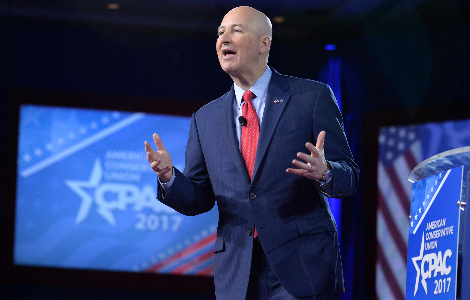
Nebraska Governor Pete Ricketts speaks at the Conservative Political Action Conference in National Harbor, Maryland, in February 2017.
MIKE THEILER / AFP via Getty Images
“It’s a bit of a straw man,” Schutz, the University of Nebraska water law expert, said of Nebraska’s concern about the Colorado projects. “A lot of those projects that [Colorado] is proposing wouldn’t actually decrease the availability of water.”
Even so, the century-old treaty gave Nebraska the theoretical rights to build a canal of its own, and the state had plenty of money to pursue such a project. That was thanks to President Biden’s American Rescue Plan, which doled out billions of dollars of pandemic recovery aid to Nebraska and left the state with a significant budget surplus. The state’s unicameral legislature has spent most of this year’s session trying to find ways to spend down that surplus, and the $500 million canal project was a perfect candidate. The legislature passed a bill in April that allocated $50 million to start canal construction, enough to start purchasing land in Colorado and conduct preliminary designs.
The legislature’s sudden move on the bill came as a shock to water experts. As one Colorado water manager put it, “the water world was rocked” when the bill passed.
That’s because, according to Schutz, the very premise of the canal project is flawed. Ricketts argued that the canal would avert a “decrease [in] agricultural water supplies and [increased] pumping costs,” but neither scenario is in the cards, even if Colorado’s population keeps growing. Nebraska relies on groundwater for more than 80 percent of its farming irrigation, and the water that comes from the hypothetical canal would only arrive during the offseason anyway, so it wouldn’t help the state’s farmers. Meanwhile, the state’s water rights only cover one section of the South Platte, and Colorado has unlimited rights over a section of the river farther upstream, meaning the Centennial State can sustain future growth even without encroaching on Nebraska’s water.
Furthermore, Schutz says, it isn’t clear that there’s even enough water in the river to fill the canal, should it ever be built.
“If you look at the amount that’s coming in right now, that’s probably the maximum amount of water that we would ever get in the canal,” he told Grist. “And that is not a lot of water.” Not only that, but the treaty also only gives Nebraska the right to build a canal that can divert 500 cubic feet of water per second. It doesn’t actually give the state the right to that much water.
“From a political perspective, I think that the governor had to make Colorado into a bad guy, but then when you really get into the weeds I don’t know how bad of a guy Colorado is,” Schutz said, arguing that the state’s conservative government has been straining to find ways to spend away the federal stimulus money so that lawmakers “don’t have to deal with the political dynamics of having a bunch of extra cash to spend on social programs.”
As the bill neared passage this spring, the two governors sniped back and forth at each other in the media. Colorado Governor Polis called the project a “boondoggle” and said his state would “aggressively assert” its water rights. Ricketts shot back: “I didn’t know Jared Polis was so concerned about taxpayers here in Nebraska…. In fact, he’s never really talked to me.”
For now the debate is just a war of words, but it could escalate if the canal moves forward. Colorado and Nebraska have sued each other in the past over water, and indeed Colorado reached a settlement with Nebraska just a few years ago over claims that Colorado violated a water-sharing compact on a different river. Building the canal would require Nebraska to purchase or condemn farmland across state lines in Colorado, which would likely lead to litigation from private landowners as well. Colorado probably wouldn’t sue Nebraska until the latter actually began to build the canal, but if it did sue, the dispute would go straight to the U.S. Supreme Court.
The fact that such a minor water project can generate so much controversy is a sign that water security is becoming a key political issue even in places where the drought situation is not yet catastrophic. The century-old compact between Nebraska and Colorado, like the treaties that anchor the use of the Colorado River farther to the west, was designed in an era of cooperation and compromise between the states. As water supplies across the region continue to vanish, though, that interstate friendliness is vanishing with them. In its place has emerged a conflict over how to balance competing interests like agriculture and urban growth. In this case, though, the conflict is more reminiscent of a schoolyard fight than a grand political debate.
For the first time, the United States government will approach water scarcity as a national security issue, Vice President Kamala Harris said this week.
The policy shift is part of the newly announced White House Action Plan on Global Water Security, which aims to “elevate water security” as an international priority. The strategy calls on the U.S. to take steps to decrease instability caused by dwindling global water supplies, an issue made more severe by climate change.
“This action plan will help our country prevent conflict and advance cooperation among nations, increase equity and economic growth, and make our world more inclusive and resilient,” Harris said in a speech on Wednesday. “Water scarcity is a global problem, and it must be met with a global solution.”
Water security is defined by the United Nations as the ability to access adequate amounts of “acceptable quality water” to sustain human health, livelihoods, and socioeconomic development, while also preventing water pollution and water-related disasters, as well as preserving ecosystems. By 2030, almost half the global population will experience “severe water stress” due to climate change and population growth, the new White House action plan points out, with communities lacking access to safe drinking water and sanitation as well as water for agriculture and energy.
The plan acknowledges that the U.S. faces a host of water crises within its own borders, from the dangers posed by lead pipes and other forms of aging water infrastructure to the decades-long megadrought in the West that’s stressing agricultural areas, urban centers, and tribal nations alike. Under the bipartisan infrastructure law passed last fall, the government will fund $63 billion in investments to address domestic issues like lead contamination, increase drinking water access, and boost drought resilience in the years ahead.
But the new national security strategy builds on previous warnings that global water insecurity can affect the U.S., too. Last October, the Office of the Director of National Intelligence released a report outlining the effects of climate change on national security, warning that with rising temperatures, “there is a growing risk of conflict over water and migration” that could end up “creating additional demands on U.S. diplomatic, economic, humanitarian, and military resources.”
Though the action plan announced by Harris did not include dollar amounts, it instructed U.S. agencies to assist communities with financing projects to provide water and sanitation infrastructure. It expressed support for technological solutions like desalination, a controversial process that involves removing the salt from seawater and requires large amounts of energy, though it emphasized that doing so should not rely on fossil fuels. At the same time, it also said the U.S. would help countries conserve and better manage their water by sharing data and technological expertise, allowing communities to more accurately prepare for shifting water availability due to climate change.
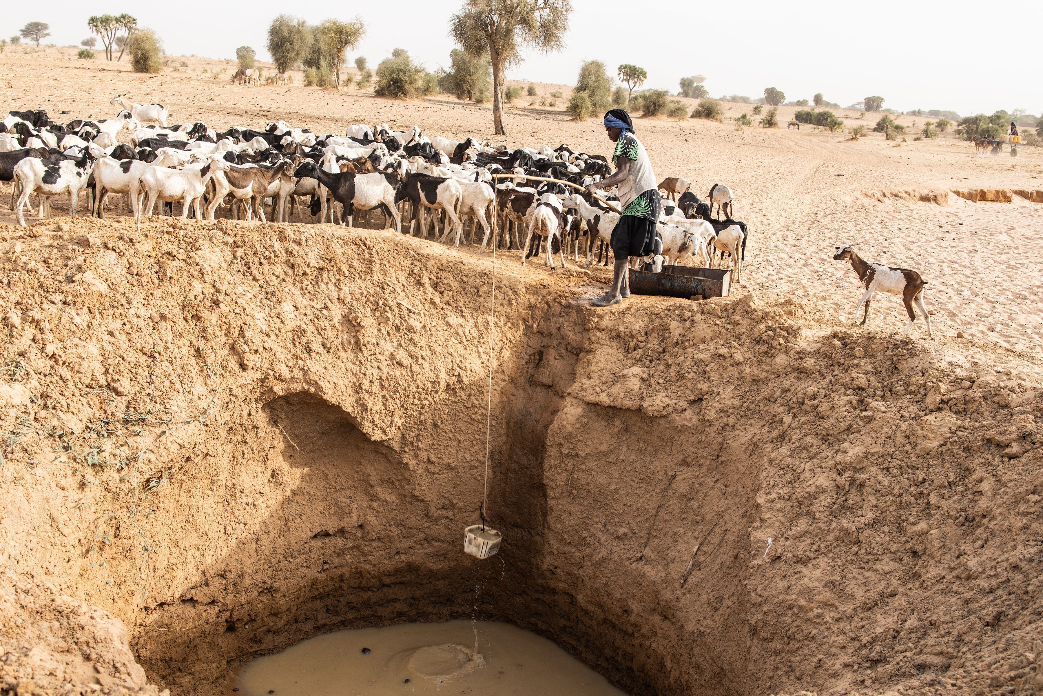
A herder collects water for his sheep from a makeshift water well in Senegal. Conflict between herders and farmers has escalated because of dwindling water resources in Africa’s Sahel. JOHN WESSELS/AFP via Getty Images
Although the link between water and conflict isn’t always direct, a wide body of research backs up the idea that water scarcity helps drive conflict or makes it more likely to happen in regions that are already struggling with other problems. Lack of access to water makes it more difficult for communities to produce food and promote economic growth, which can lead to mass protests as well as migration that puts pressure on neighboring countries. (Though not mentioned in the action plan, a hallmark of Harris’ vice presidency has been urging migrants from Central America, many of whom have faced increasing climate impacts in their home countries, to not migrate to the U.S.).
And although “water wars” haven’t broken out on the scale that some leaders predicted, disputes over limited water resources can still provoke armed conflict. Research from the Pacific Institute, a U.S.-based nonprofit that studies issues related to water access and resilience, shows that over the last decade, water has become a more common “trigger” for conflict than a weapon or casualty of war.
These pressures have already driven conflicts in the Sahel region of Africa, where a growing population and declining water resources exacerbated by climate change have led to tensions between farmers and pastoralists, causing an estimated 15,000 deaths since 2010. In 2021, protests erupted in Iran over water shortages, leading to a government crackdown.
The new White House plan was applauded by nonprofit organizations like the World Wildlife Fund, which emphasized the need to create “resilient” water systems that can withstand shocks like climate change. Others pointed out the role that the U.S. must play in addressing climate change as one of the world’s biggest sources of greenhouse gases, the root cause of climate-driven drought.
“Freshwater ecosystems harbor a wealth of critical resources for humanity, including drinking water, food, and means for economic growth,” Sarah Davidson, the fund’s director of freshwater policy, said in a statement. “We welcome the Administration’s plan to elevate water security and resilience, and support immediate steps to integrate freshwater health into sound infrastructure, energy, development, and climate-smart investments at home and abroad.”
Around noon one day in January 2019, a dam containing waste from a Brazilian iron mine collapsed, releasing 3.4 million tons of sludge. The cascade killed 272 people and flattened houses and buildings for miles, including the mine’s offices and cafeteria, before emptying into the Paraopeba River in southeastern Brazil.
Such disasters have been increasing in frequency and severity, according to a new report on mining waste management. Published by a trio of environmental groups on Tuesday, the report calls for revamping the industry’s standards. It comes as mining companies around the world ramp up the extraction of minerals needed to transition from fossil fuels to forms of cleaner energy.
Mining produces a lot of waste, often toxic: byproducts like lead or arsenic leached from the earth, chemicals like ammonia and cyanide, and processed rock or wastewater. These so-called “tailings” are stored in vast, sludgy pools as big as lakes and contained by earthen dams. According to Earthworks, MiningWatch Canada, and the London Mining Network, which authored the report, current industry standards are far from adequately protecting people and the environment. Their report is backed by an international coalition of more than 150 community groups, environmental organizations, Indigenous communities, and scientists.
Extreme rainfall driven by climate change stresses these structures, known in the industry as tailings dams. “Addressing the problems of mine tailings management is more urgent than ever,” said Jan Morrill, Earthworks’ tailings campaign manager, in a release. “We must prioritize safety over cost.” Dams should be designed to endure the most extreme weather and seismic events possible at any given location, the report said.
At the same time, the rush toward renewable energy is driving up the need for minerals like copper or cobalt, used in wind turbines, rechargeable batteries, and electric vehicles. The authors estimate that demand for these commodities will rocket by 300 percent to 8,000 percent in the next 30 years. Over time, the quality of ore has also declined, forcing companies to process twice as much earth to obtain the material they seek — doubling the amount of waste produced than before.
These factors, combined with weak industry regulations, are putting pressure on the thousands of waste dams thought to be in existence. The collapse of the Brazilian mine, owned by the company Vale, in 2019 is one of the most catastrophic in a string of failures that have occurred worldwide. Just four years earlier, a breached iron dam — also Vale-owned — in nearby Mariana, Brazil, killed 19 people. A year before that, a pool of toxic green waste — the size of New York’s Central Park — at a gold-copper mine in British Columbia poured into surrounding lakes, creeks, and forests.
Among the authors’ recommendations for strengthening the dam standards are regular monitoring and inspection of the waste facilities; obtaining ongoing consent from neighboring communities; and annual evacuation drills with community members in case of a ruptured dam. They said new waste dams shouldn’t be built if companies can’t ensure safe evacuations.
Better yet, the report said, don’t use waste dams at all: “The safest tailings facility is one that is not built.” While some mining may be necessary to foster new technologies, the current trends aren’t sustainable, the report warns. Companies should develop methods to recycle scarce minerals or extract them from unconventional supplies like wastewater.
Hurricane Agatha, the first named storm of this year’s Pacific hurricane season, slammed into the coast of southwest Mexico on Monday, bringing coastal flooding, heavy rain, and sustained winds of 105 miles per hour. It was the strongest storm to hit Mexico’s Pacific coast in the month of May since record keeping began in 1949.
The National Hurricane Center predicts that the remnants of the storm will cross into the Gulf of Mexico or Caribbean, and could spawn the first named storm of the Atlantic season, which kicks off June 1. This comes a week after the National Oceanic and Atmospheric Administration, or NOAA, issued its annual hurricane season outlook, forecasting “above-average” hurricane activity in the Atlantic for the seventh year in a row.
Agatha rapidly intensified into a Category 2 hurricane off the coast of Mexico on Sunday and made landfall in the state of Oaxaca the next day. The torrential rains caused mudslides, blocking two highways in Oaxaca, and some towns lost power and telephone lines. At least three people were killed.
The storm weakened as it traveled inland and over mountains, but could gain new life when it reaches the Atlantic. On Tuesday afternoon, forecasters with the National Hurricane Center predicted that what’s left of Agatha will collide with an area of low pressure currently spinning over southeastern Mexico, saying there’s a 70 percent chance that it could turn into a new tropical depression or storm named Alex once it crosses into the Gulf of Mexico or the Caribbean Sea.
If Agatha does morph into Alex, it will kick off an Atlantic hurricane season that’s expected to be a busy one. NOAA predicts there will likely be 14 to 21 named storms this year, with six to 10 becoming hurricanes with winds of at least 74 miles per hour — including three to six major hurricanes with winds of at least 111 miles per hour. Forecasters attribute the increase in expected hurricane activity to several factors, including the ongoing La Niña, which affects oceanic and atmospheric circulation globally, a strong west African monsoon, which creates wind patterns that can spin up storms across the Atlantic, and warmer than average sea surface temperatures, which can fuel the rapid intensification of storms.
Rising sea surface temperatures are just one way that climate change is influencing hurricanes, according to NOAA. Warmer temperatures mean the atmosphere can hold more moisture, allowing hurricanes to dump more rain. Higher sea levels mean storm surges are inundating more of the coast. A recent study published in the journal Weather and Climate Dynamics found that climate change has “contributed to a decisive increase in Atlantic Ocean hurricane activity” since the 1980s and doubled the chances for extreme seasons like 2020 — when 31 named storms made it the busiest on record.
As 2021 drew to a close, rain and snow pummeled California, raising hopes that the state’s ongoing drought would be alleviated. But the tap dried up in January, and historically low precipitation followed. Now, as summer approaches, it’s clear that those few months of reprieve did little to shore up the state’s water reserves, and analysts are warning that the state’s hydroelectric supplies — a cheap source of clean power in California — are once again at risk.
The U.S. Energy Information Administration, or EIA, reported last week that as reservoir levels dip far below their historic averages, electricity generation from California’s hydroelectric dams could be cut in half this summer. The shortfall is likely to be made up in part by an increase in natural gas-fired power, EIA said, sending more carbon dioxide and pollution into the air and pushing up summer electricity prices in the state.
“There is a growing recognition that hydropower may not be the reliable resource that it has been historically,” said Mike O’Boyle, director of electricity policy at the think tank Energy Innovation.
In 2019, prior to the current drought, 19 percent of in-state electricity generation came from hydroelectric dams, according to data from the California Energy Commission. In 2020, hydro dropped to just over 11 percent of the in-state power mix due to the effects of heat and drought. Now, EIA predicts that number could drop to just 8 percent this summer.
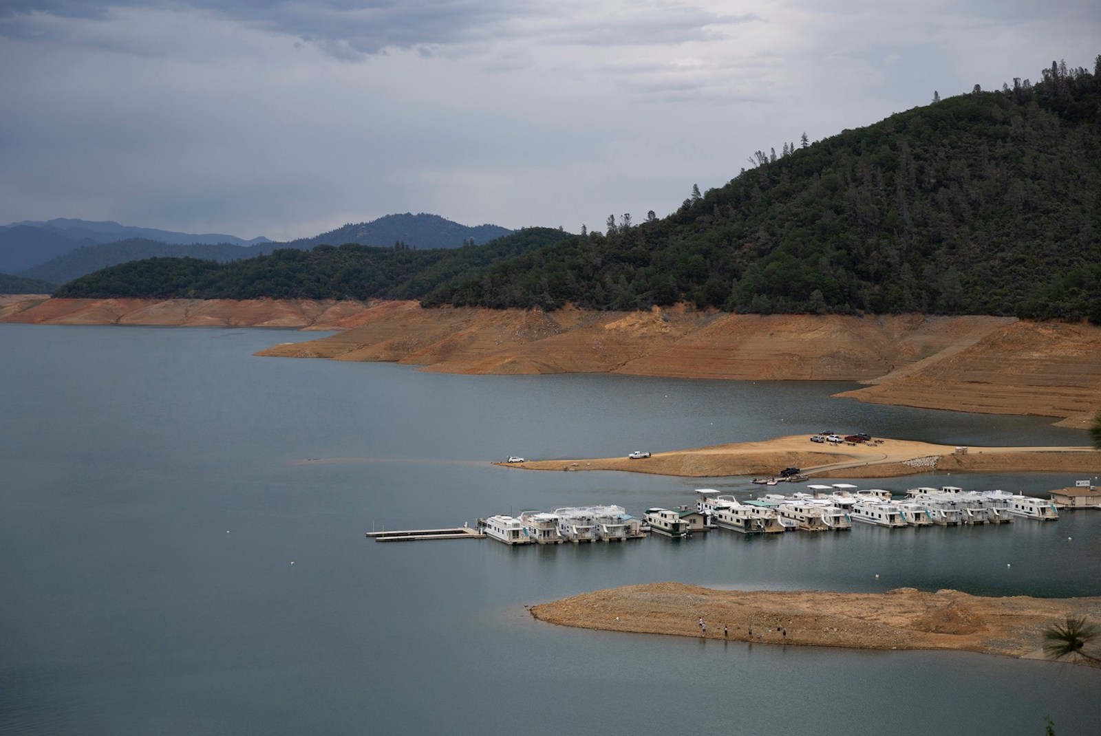
Hydropower plants are typically a crucial source of clean, “dispatchable” energy for the grid. Dam operators can ramp up or down electricity production by releasing more water to meet the grid’s needs as wind and solar output varies. But with reservoirs low, this flexibility will likely be compromised, EIA writes. The state’s two largest reservoirs, Lake Shasta and Lake Oroville, are at 48 percent and 67 percent of their historical average, respectively. As of April 1, snowpack throughout the state was just a third to half of normal levels, meaning there will be less melting snow to recharge already depleted reservoirs.
During the summer of 2021, hydropower from Lake Oroville had to go offline for the first time since the plant started operations in the 1940s.
drought.ca.gov
To make up for the shortfall, California’s grid operators will purchase more out-of-state power, but they will also turn to one of the only other sources of dispatchable power at their disposal: natural gas power plants. The EIA predicts that natural gas will rise to 50 percent of in-state generation this summer, increasing carbon dioxide emissions by 978,000 metric tons, or the equivalent of putting about 211,000 more cars on the road for a year.
In addition to the environmental and public health consequences, this switch to natural gas will also be felt by Californians’ wallets. The study finds that wholesale electricity prices — the price that utilities pay for power — could increase by 7 percent in Northern California and 5 percent in Southern California.
The shrinking prospects for hydropower on a warming planet is something California will need to contend with as it forges a path to 100 percent clean electricity by 2045. California Energy Commission staff told Grist in an email that currently, the state uses the 15-year historic average of hydroelectric availability in its models — a metric that may not capture the challenge that lies ahead. But they are “expecting to run more scenarios to capture potential impacts of droughts in long term planning.”
Michael Colvin, an expert on California energy policy at the nonprofit Environmental Defense Fund, told Grist that in the long run, hydropower shortfalls could lead the state to delay the retirement of some existing natural gas plants, though it’s unlikely to build new ones. “When you look at what the load-serving entities are buying, they are almost all utility scale solar and storage (or just stand alone storage) contracts,” he said in an email.
That trend of relying so heavily on solar and storage is slightly worrisome to O’Boyle of Energy Innovation. The organization recently analyzed how California could achieve 85 percent renewable energy by 2030 without compromising reliability. The study found that even in a scenario with low hydropower, California can build enough renewable energy supplies to hit 85 percent, meet demand, and maintain reliability – but that diversification of energy sources was key. He said California should be investing more in offshore wind, geothermal, and other measures that reduce strain on the grid.
“If for some reason, solar is unavailable from cloud cover from wildfire smoke — that was an issue a few years ago — then a more diverse set of resources can perform better under those extreme conditions,” O’Boyle said.
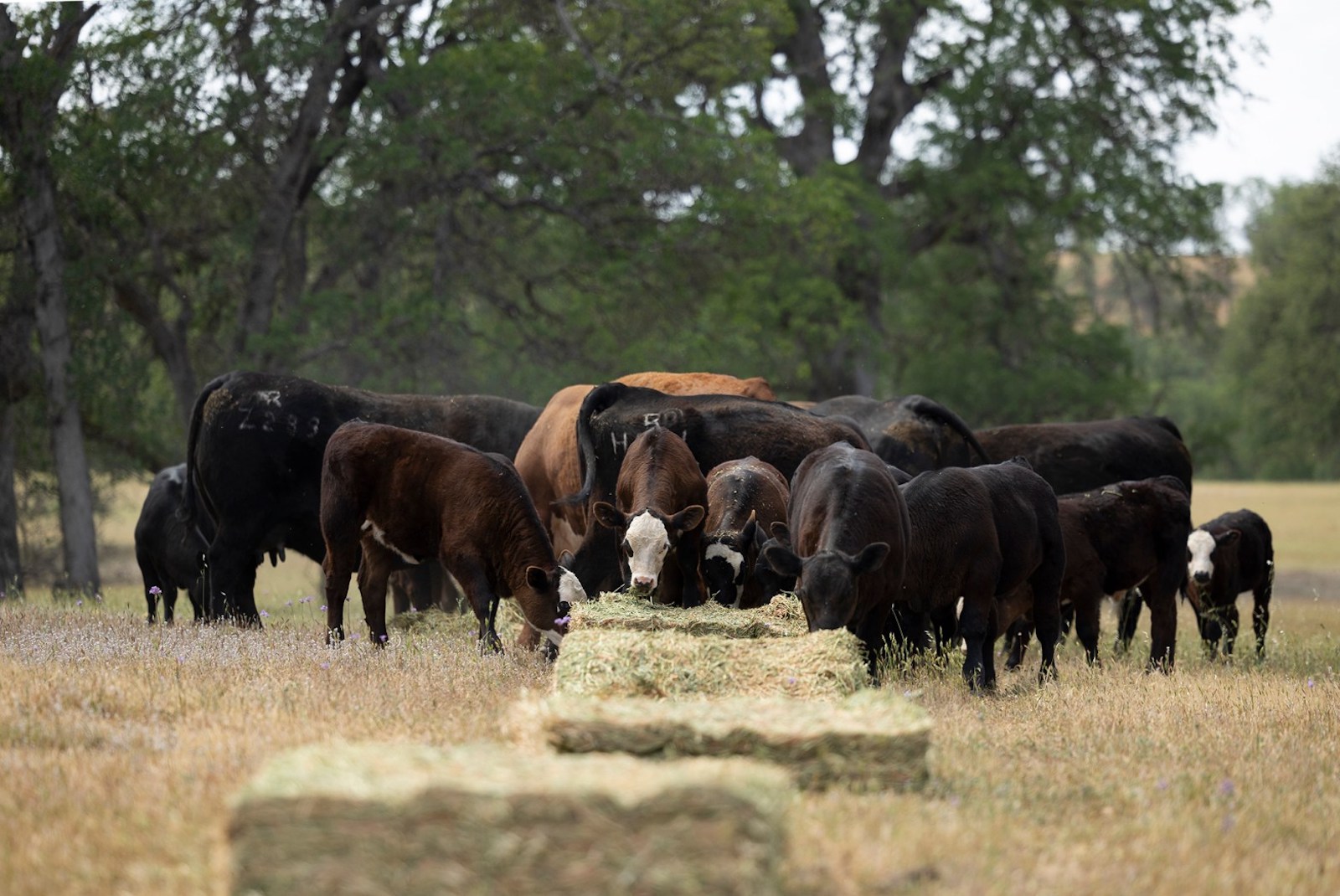
Standing on the grassy plateau where water is piped onto his property, Josh Davy wished his feet were wet and his irrigation ditch full.
Three years ago, when he sank everything he had into 66 acres of irrigated pasture in Shasta County, Davy thought he’d drought-proofed his cattle operation.
He’d been banking on the Sacramento Valley’s water supply, which was guaranteed even during the deepest of droughts almost 60 years ago, when irrigation districts up and down the valley cut a deal with the federal government. Buying this land was his insurance against droughts expected to intensify with climate change.
But this spring, for the first time ever, no water is flowing through his pipes and canals or those of his neighbors: The district won’t be delivering any water to Davy or any of its roughly 800other customers.
Without rain for rangeland grass where his cows forage in the winter, or water to irrigate his pasture, he will probably have to sell at least half the cows he’s raised for breeding and sell all of his calves a season early. Davy expects to lose money this year — more than $120,000, he guesses, and if it happens again next year, he won’t be able to pay his bills.
“I would never have bought (this land) if I had known it wasn’t going to get water. Not when you pay the price you pay for it,” he said. “If this is a one-time fluke, I’ll suck it up and be fine. But I don’t have another year in me.”
Since 1964, the water supply of the Western Sacramento Valley has been virtually guaranteed, even during critically dry years, the result of an arcane water rights system and legal agreements underlying operations of the Central Valley Project, the federal government’s massive water management system.
But as California weathers a third year of drought, conditions have grown so dry and reservoirs so low that the valley’s landowners and irrigation districts are being forced to give up more water than ever before. Now, this region, which has relied on the largest portion of federally-managed water flowing from Lake Shasta, is wrestling with what to do as its deal with the federal government no longer protects them.
An irrigation canal on Davy’s pasture in Shasta County is bone-dry on April 27, 2022. Miguel Gutierrez Jr. / CalMatters
All relying on the lake’s supplies will make sacrifices: Many are struggling to keep their cattle and crops. Refuges for wildlife also will have to cope with less water from Lake Shasta, endangering migratory birds. And the eggs of endangered salmon that depend on cold water released from Shasta Dam are expected to die by the millions.
For decades, water wars have pitted growers and ranchers against nature, north against south. But in this new California, where everyone is suffering, no one is guaranteed anything.
“In the end, when one person wins, everybody loses,” Davy said. “And we don’t actually solve the problem.”
This parched valley was once a land of floods, regularly inundated when the Sacramento River overflowed to turn grasslands and riverbank forests into a vast, seasonal lake.
The river was corralled by levees, the region replumbed with drainage ditches and irrigation canals. Grasslands and swamps lush with tules turned to ranches and wheat fields, then to orchards, irrigated pasture and rice.
The federal government took over in the 1930s, when it began building the Central Valley Project.’s Shasta Dam, which displaced the Winnemem Wintu people. A 20-year negotiation between water rights holders and the United States’ Bureau of Reclamation culminated in a deal in 1964.
Today, under the agreements, which were renewed in 2005, nearly 150 landowners and irrigation districts that supply almost half a million acres of agriculture in the western Sacramento Valley are entitled to receive about three times more water than Los Angeles and San Francisco use in a year.
It’s a controversial amount in the parched state. Before this year, the Sacramento River Settlement Contractors, as they’re called, received the largest portion of the federally-managed supply of water that flows from Shasta Lake. It’s more than cities receive, more than wildlife refuges, more even than other powerful agricultural suppliers like the Westlands Water District farther south.
Their contract bars the irrigation districts’ supply from being cut by more than a quarter in critically dry years. During the last drought in 2014, federal efforts to cut it to 40 percent of the contracted amount were met with resistance, and deliveries ultimately increased to the full 75 percent allocation for the dry year.
But this year, facing exceptionally dry conditions, the irrigation districts negotiated with state and federal agencies, and agreed in March to reduce their water deliveries to 18 percent. Other agricultural suppliers with less senior rights are set to get nothing.
Low water levels at Shasta Lake on April 25, 2022.
Miguel Gutierrez Jr. / CalMatters
Growers understand that they have to sacrifice some water this year, said Thaddeus Bettner, general manager for Glenn-Colusa Irrigation District, the largest of the Sacramento River Settlement Contractors and one of the largest irrigation districts in the state. But he wondered why irrigation districts in the Western Sacramento Valley draw so much of the blame.
“I understand we’re bigger than everybody so we catch the focus,” Bettner said. “We’re just trying to survive this year. Frankly, it’s just complete devastation up here. And it’s unfortunate that the view seems to be that we should get hurt even more to save fish.”
Cutting deliveries to growers means that more water can flow through the rivers, which slightly raises the chances for more endangered winter-run Chinook salmon to survive this year.
“They had the water rights to take 75 percent of their allocation instead of 18 percent, and we were anticipating another total bust,” said Howard Brown, senior policy advisor with NOAA Fisheries’ West Coast Region. “One hundred percent temperature dependent mortality (of salmon eggs) would not have been something out of reason to imagine.”
Yet more than half of the eggs of endangered winter-run Chinook salmon are expected to still die this year, according to the National Marine Fisheries Service.
State and federal biologists are racing to move some of the adult salmon to a cooler tributary of the Sacramento River and a hatchery.
“We’re spreading the risk around, and putting our eggs in different baskets,” Brown said. “The animal that’s on the flag of California is extinct. How many can we afford to lose before we lose our identity as people and as citizens of California?”
In any other year, Davy would run his cattle on rain-fed rangeland he leases in Tehama County until late spring before moving the herd to his home pasture, kept green and lush with spring and summer irrigation.
Davy, who grew up roping and running cattle, supports his career as a full-time rancher with his other full-time job as a farm advisor with the University of California Cooperative Extension, specializing in livestock, rangelands, and natural resources.
Three years ago, he sold his home in Cottonwood, on the Shasta-Tehama county line, for a fixer-upper nearby with holes in the floor, a shoddy electrical system and windows that wouldn’t close. This fixer-upper had two inarguable selling points: a view of Mount Shasta and water from the Anderson-Cottonwood Irrigation District, a settlement contractor.
This year, without rain, the grass where his cows forage through the winter crunches underfoot.
“This grass should be up to my waist right now,” Davy said, readying a chute he would soon use to transport his cattle. He unloaded hay from his pickup to feed the cows and calves until he could move them — unheard of, he said, in April.
Cattle feed on hay in Tehama County.
Miguel Gutierrez Jr. / CalMatters
Forty miles away, his pasture, green from the April rains, is faring a little better — but the green can’t last without irrigation. Thinking about it too hard makes Davy feel sick.
“I try to stick to what I can get done today, and then assume next year I’ll be okay. I think that’s the mantra for agriculture,” he said: “Next year will be better.”
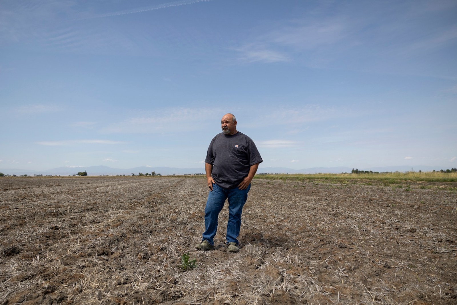
About 75 miles south of Davy’s ranch, rangeland and irrigated pastures open up to orchards and thousands of acres of empty rice fields.
“Nothing like I thought I’d ever see,” said Mathew Garcia, gazing at one of his dry rice fields in Glenn, about an hour and a half north of Sacramento.
In any other year, he would have been preparing to seed and flood the crumbled clay. This year, he had to abandon even the one field he’d planned to irrigate from a well. The ground was too thirsty to hold the water.
Garcia’s water comes from two different irrigation districts with settlement contracts. This year, the roughly 420 acres he farms will see water deliveries either eliminated or too diminished to plant rice. He’ll funnel the water instead to his tenant’s irrigated pasture where cattle graze.
“Without the water, we have dirt. It’s basically worthless,” Garcia said. “It’s very depressing.”
Garcia places some of the blame on the weather. But he also blames federal regulators, who allow water to flow from the reservoirs year-round for fish, wildlife, and water quality.
“Everybody says well, you shouldn’t farm in the desert. Does this look like a desert to you? No. It looks like fertile, beautiful farmland with the most amazing irrigation system that’s ever been put in. And they’re just taking the water from it. They’re creating a desert.”
In the depths of California’s last historic drought from 2012 through 2016, Garcia could still plant his fields. Even with last year’s reduced water deliveries, he planted — filling the gaps in water supply by pumping from his groundwater wells.
Garcia will survive this year: He credits his wife’s foresight to purchase crop insurance years ago. Without it, he said, he’d be done — he’d have to sell land, maybe find another job.
Mathew Garcia, standing in one of his fallowed rice fields in Glenn, says he can’t plant anything this year because of reduced water deliveries.
Miguel Gutierrez Jr. / CalMatters
“If this drought sustains, I don’t know how long insurance is going to last. And then at what point do you throw in the towel?” said Garcia. “There’s a teetering point somewhere. Everybody’s is different. I don’t know where mine is yet.”
Local water suppliers anticipate about 370,000 acres of cropland will go fallow in the western Sacramento Valley, the result of diminished deliveries to the settlement contractors. Most lie in Colusa and Glenn counties, where agriculture is the epicenter of the economy. Money and jobs radiate from the fields to the crop dusters and chemical suppliers, rice driers, and warehouses.
And, like the water, jobs for farm workers have dried up.
For nine years, SergioCortez has been traveling from Jalisco, Mexico to work in Sacramento Valley fields. This is the driest he’s ever seen it, and he knows that next year could be worse.
“Aquí el agua es todo, pues,” he said. “Al no haber agua, pues no hay trabajo.” Water is everything, he said. If there’s no water, there’s no work.
The parking lot at the migrant farmworker housing in Colusa County where Cortez and his family live for part of the year was full of cars and pickups that would normally be parked at the fields. Cortez hadn’t worked in two days.
For Adolfo Morales Martinez, 74, it had been a month since he worked. And, at the end of April, his unemployment benefits were about to end.
“Desesperados. Estamos desesperados,” he said. “Pues en el campo gana uno poquito, no? Y sin nada? No mas.” We’re desperate, he said. In the fields, he can earn a little. But now, nothing.
Normally Morales Martinez drives a tractor, readying rice fields for planting. Now it’s like a desert, his wife, Alma Galavez, said.
“Eso está desértico, vea. Todo. Nada, Nada. Está feo y triste,” she said. There’s nothing. It’s ugly and sad.
Environmental advocates and California tribes have been fighting the growers’ and irrigation districts’ claim to California’s finite water supply for years, citing inadequate water to maintain water quality and temperatures for endangered fish and the Delta.
“People who have built their farms in the desert, or in areas where their water has to be exported to them, need to think about changing. Because that’s what’s killing the state,” said Caleen Sisk, chief and spiritual leader of the Winnemem Wintu, whose lands were flooded with the damming of Lake Shasta.
To Sisk, the salmon that once spawned in the tributaries above the Central Valley signal the region’s health. “If there are no salmon, there will be no people soon.”
Federal scientists estimate that last year about three-quarters of endangered winter-run Chinook salmon eggs died because the water downstream of a depleted Lake Shasta was too warm. Only about three percent of the salmon ultimately survived to migrate downriver.
“It’s been clear for decades that there was a need to reduce diversions,” said Doug Obegi, senior attorney with the Natural Resources Defense Council. “The consequences are just becoming more and more extreme.”
In 2020, California sued the Trump administration over what it said were flawed federal assessments for how the Central Valley Project’s operations harm endangered species.
The judge sent the federal plans back for more work and approved what he called a “reasonable interim approach“ that called for prioritizing fish and public safety over irrigation districts. He called the contracts an “800 pound gorilla” that “make it exceedingly and increasingly difficult” for the federal government to be “sufficiently protective of winter-run (salmon).”
U.S. Bureau of Reclamation spokesperson Gary Pitzer said the agency worked with the districts to reach an agreement on how much water to deliver because “it’s the right thing to do, particularly during drought — one of the worst on record.”
Environmental advocacy groups applauded the reduced allocations to the Sacramento Valley irrigation districts. But they also raised concerns that other irrigation districts with similar contracts elsewhere in the state would still see their full dry year allocations, and cautioned that the temperatures will still kill salmon by the scores this year.
Curtis McCasland, manager of the Sacramento National Wildlife Refuge Complex, expects less than half a typical year’s water supply to be delivered to the refuges this year — cobbled together from purchased water supplies, federal deliveries and, he hopes, storm flows this winter.
North of Sacramento, the five refuges in the complex are painstakingly tended wilderness in a sea of agriculture. More than a century ago, wetlands fanned out for miles to either side of the flood-prone Sacramento River. Now, more than 90 percent of the state’s wetlands are gone, drained for fields, homes, and businesses. Those remaining in these refuges now depend on water flowing from Shasta Dam and shunted through irrigation canals.
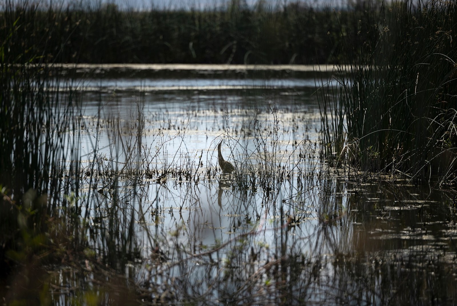
At the end of April, the Colusa National Wildlife Refuge offered an oasis among the barren rice fields, which normally provide about two-thirds of the migrating bird’s calories. Dark green bulrushes rose from shallow ponds where shorebirds jackhammered their bills in and out of the muck.
McCasland knows all this lush green can’t last. As he steered an SUV past black-necked stilts picking their way through the water and ducklings paddling ferociously, he braced for another dry year.
“Instead of being those postage stamps in a sea of rice, we’re going to be postage stamps in a sea of fallow fields,” McCasland said.
An American bittern feeds at the Colusa National Wildlife Refuge on April 28, 2022.
Miguel Gutierrez Jr. / CalMatters
In a typical year, the refuge wetlands that depend on federal water get much less water than the settlement contractors are entitled to — about four percent of the total, McCasland estimates. And he worries that this year, whatever water they do receive won’t be enough to keep all these birds fed and healthy.
More than a million birds descend on the refuges every winter to rest and find food. More stop in the surrounding rice fields, which are largely dry this year.
“In years where Shasta is at a normal or average level, it should be no problem to get us the water,” he said. “In years like this, certainly it’s going to be terribly difficult.”
The drought may already have taken a toll. Last November, only 745,000 birds landed in the refuge, a decrease of more than 700,000 from November of 2019, although some may have remained farther north because of unseasonably balmy weather there.
The refuges are like a farm, where McCasland and his colleagues carefully cultivate tule, shrubs, and grasses with pulses of summertime irrigations. With less water this summer, these wintertime food sources for birds will dry and shrivel. And with less water during the peak of fall and winter migrations, hungry birds will be packed together in the few remaining marshes — raising the risk of outbreaks from diseases like avian botulism or cholera.
“There’s not a lot of places for these birds to go,” he said. “The Sacramento Valley has always been the bankable piece….They do have wings, they may be able to move through.” But, he added, “the question is, what happens next?”
CalMatters Photo Editor Miguel Gutierrez contributed to this story.
This article was originally published by CalMatters, and is reprinted with permission. CalMatters.org is a nonprofit, nonpartisan media venture explaining California policies and politics.
This summer is not going to be easy for Matt Watkins. The 39-year-old farmer runs a citrus operation in Tulare County, on the southeast side of California’s Central Valley, and he irrigates his trees using water from a federal canal system. Earlier this year, the federal government informed farmers in his area that it would be delivering only 15 percent of a typical year’s water allotment, thanks to a severe regional drought that has sapped the reservoirs and rivers that are supposed to replenish the canals.
Watkins’s trees need regular watering over the course of the year in order to produce California’s famous oranges, but this summer the water from the federal canal will only last him a month. He and other nearby farmers are pumping unreliable groundwater to make up the difference, hoping their already struggling wells don’t go dry, or are purchasing water for exorbitant rates on an informal local market. Others will rip up their trees and leave their fields fallow.
“We’re year to year right now,” Watkins told Grist. “If it doesn’t rain next year, there could be a pretty big catastrophe for farming. It’s getting down to the point where there’s not much flexibility. There’s probably some small family farmers that may not survive completely.”
About 100 miles away, on the northwest side of the Central Valley, the situation could not be more different. Even during an unprecedented drought, the almond and pistachio farmers around the city of Los Banos will get around 75 percent of a normal year’s water, far more than almost any other group of growers in California. These farmers grow many of the same crops as the farmers on the southeast side, and the water they use comes from the same canal system. Yet while Watkins has almost no water, these farmers have plenty.
The startling contrast is the result of an obscure and contentious legal agreement known as the exchange contract, which dates back to the early twentieth century. This contract never mattered much during wet years, but during droughts it allows a small group of Central Valley farmers to claim enormous amounts of water while their neighbors make deep cuts. As the overall water shortage only deepens, the arcane legal precedent has pitted two groups of farmers against each other, opening up a rift in an industry that more often finds itself united in opposition to outside parties like environmentalists.
The aridification of the American West is straining the region’s antiquated water management system, draining reservoirs that have been full for decades and forcing the government to make new and painful decisions that privilege some groups at the expense of many others. Bigger water cuts could prove devastating for the Central Valley’s economy: A study of last year’s drought produced by the University of California, Merced, found that the water shortage caused $1.7 billion in economic losses and also resulted in the loss of more than 8,000 jobs, many of them among vulnerable migrant laborer populations. The effects aren’t limited to California. The Central Valley provides an enormous share of the nation’s fruits, vegetables, and nuts, and many of the crops are grown almost nowhere else in the country. If production continues to fall, there will be price impacts at grocery stores nationwide.
The exchange contract isn’t the source of these problems, but it does ensure that while most farmers struggle to make do with dramatically less water, a few will remain artificially insulated from the effects of climate change, which has enhanced the West’s ongoing megadrought — all thanks to water rights acquired generations earlier.
“We have a water rights system that is based on this principle of ‘first in time, first in right,’ where landowners were able to go out and post a sign on a tree and start diverting water. And just by the act of taking the water, it became theirs,” said Doug Obegi, director of California river restoration projects at the Natural Resources Defense Council.* “But that was only made available by the fact that the settlers had wiped the Native people off of the land. We have now a system that, a hundred-plus years later, is still maintaining that privilege, and leading to this inequity where you have some water districts getting very little water and others getting a lot.”
Officially, water rights in the U.S. operate on a principle of seniority. If you used a body of water first, you usually have a stronger legal claim to it than someone who started using it after you. This very simple principle can lead to some very complicated outcomes.
In the late nineteenth century, a California settler named Henry Miller built a cattle empire on the western side of the Central Valley, amassing over a million acres of land alongside the San Joaquin River. Miller and his partners claimed this land and used water from the San Joaquin to irrigate it, thus acquiring formal rights to the river water.
A few decades later, in the 1930s, the U.S. Bureau of Reclamation began building a series of dams and reservoirs in the mountains around the Central Valley. As in other parts of the West, the purpose of the dam system was to enable large-scale farming by creating massive water storage facilities. One of Reclamation’s goals was to redirect the San Joaquin River from the northern side of the valley to the drier southern side, diverting the flow of the river away from Miller’s cattle empire so it could irrigate more than a million acres of new farmland.
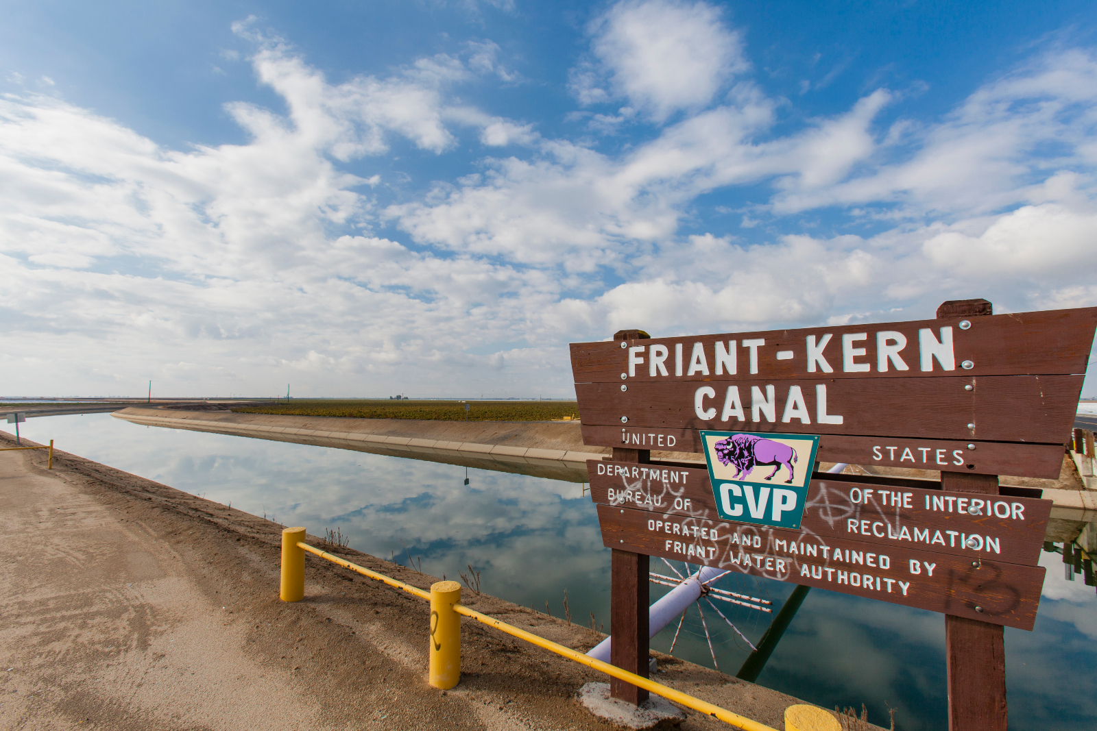
The Friant-Kern Canal is an irrigation canal and part of the Central Valley Project aqueduct.
Citizens of the Planet / Education Images / Universal Images Group via Getty Images
In order to redirect the river, Reclamation had to compensate the farmers who used Miller’s land, since they had formal rights to the water from San Joaquin River. The two parties worked out a unique deal: If the farmers surrendered their rights to the San Joaquin River, the government would provide them with an equal amount of water from anothernearby river, the Sacramento.
If the Sacramento ever failed to provide the farmers with enough water, however, they could claim water from the San Joaquin, which was now flowing into the southern part of the valley. If the farmers on Miller’s land made such a claim, Reclamation would have to take the water away from the farmers in the southern part of the valley, move it through the canal system, and deliver it to the farmers on Miller’s land.
In other words, the farmers on Miller’s land had the rights to water from two different rivers, and they could cut ahead of other users in the event of a water shortage. These irrigators became known as the “exchange contractors,” and today they produce tens of thousands of acres’ worth of tomatoes, lettuce, pistachios, and almonds, making up a massive share of the Central Valley’s agricultural output. Their typical year’s water allocation is 875,000 acre-feet, equivalent to about half of Los Angeles County’s water supply.
For almost a century, the exchange agreement was just a hypothetical. That ended in 2014, during the start of California’s last major drought, when water levels dropped so low that Reclamation couldn’t provide any water to the exchange contractors. Pursuant to their original agreement with the federal government, the exchange contractors claimed their rights to water from San Joaquin, effectively seizing the water from farmers in the eastern part of the valley known as the Friant division, which is where Watkins has his citrus farm. The exchange contractors got a giant allocation of water, and the Friant farmers took a sizable cut, forcing them to pump groundwater or leave their crops unplanted. The same thing happened the next year.
In response to Reclamation’s decision, a group of water users led by the city of Fresno and several Friant irrigation districts filed a lawsuit against the federal government and the exchange contractors. The Friant districts alleged that, in fulfilling its contractual obligation to the exchange contractors, the federal government breached its contractual obligation to the Friant districts, failing to provide them with an adequate amount of water. After more than seven years, that lawsuit is still ongoing, though a decision is expected soon.
Meanwhile, California has entered the second year of another massive drought, and Reclamation has once again found itself between a rock and a hard place. While there is more water in the reservoir that flows to the Friant districts than there was last year, Reclamation is holding back that water so it can save it for the exchange contractors — for the third time in a decade.
This has created an almost surreal split-screen effect in the Central Valley. On the west side of the valley, in the irrigation districts that benefit from the exchange contract, farmers are proceeding more or less as they always have. On the east side of the valley, meanwhile, the situation is dire.
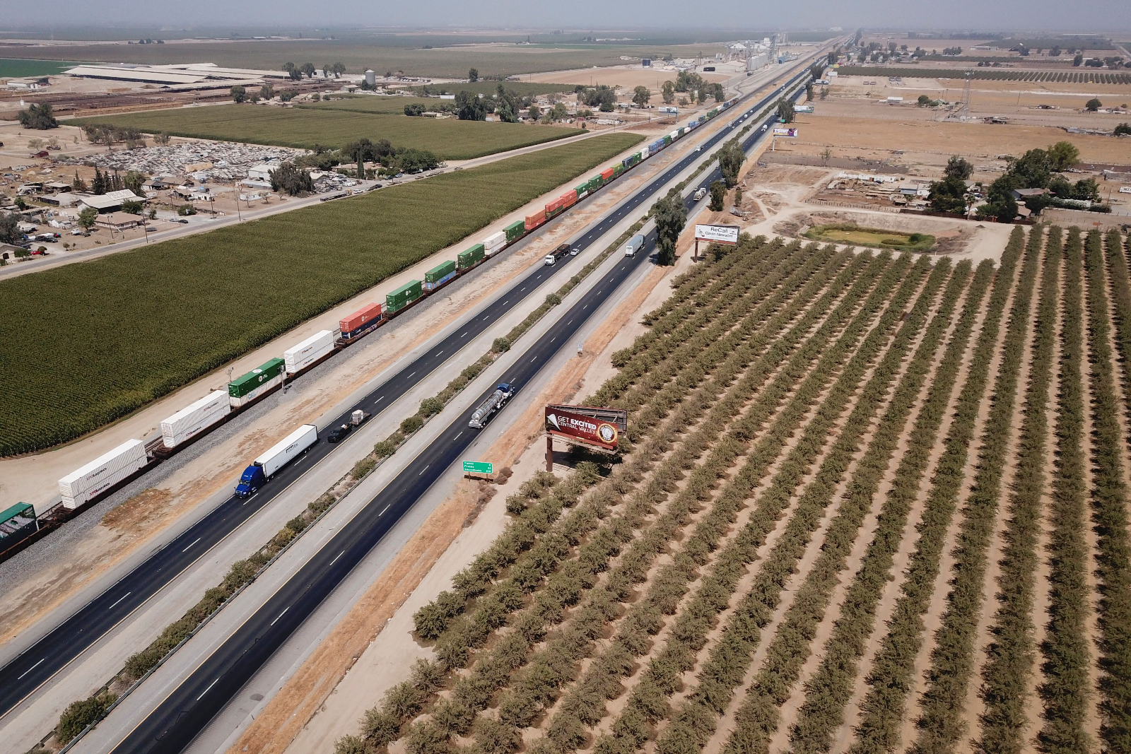
Vehicles drive past farmland and a freight train though Tulare County in the Central Valley near Pixley, California, in 2021.
PATRICK T. FALLON / AFP via Getty Images
“The tension is palpable,” said Tricia Stever Blattler, the executive director of the Tulare County Farm Bureau, whose farmers rely on water from the Reclamation system. “A lot of farmers are fearing they will have to fallow ground and push trees and vines out. There’s speculation about selling land.”
Aaron Fukuda, the general manager of the Tulare Irrigation District, echoed that sentiment.
“The situation has become significantly worse as surface water deliveries are again curtailed this year, forcing growers to turn to groundwater,” he told Grist. In a typical dry year, many farmers can pump subterranean water from wells in order to make up for lost reservoir water, but that isn’t an option for many farmers in the area.
“Our groundwater levels have yet to recover from the last drought, so many [areas] are implementing groundwater cutbacks, which ultimately reduces the ability of growers to meet their crop demands,” he added. A state law passed during the last drought led to further restrictions on pumping, which leaves farmers in the valley with fewer options than ever.
The Natural Resources Defense Council’s Obegi says that the Bureau of Reclamation could soon push to renegotiate the exchange contract if it wanted to, potentially capping the water deliveries that go to the contractors and curbing degradation of the San Joaquin River in the process. The revision would be painful for the exchange contractors, but it would lead to a more equitable distribution of water in the valley during drought years. It would also help restore fish populations in the San Joaquin River, pursuant to a 2006 settlement in a lawsuit brought by environmental groups including the Natural Resources Defense Council.
Ernest Conant, the regional director for Reclamation’s mid-Pacific division, said the exchange contract is a reflection of Western water law, and that the authority is bound by law to honor the contract, even if it means diverting water from other parties.
“People may think this is just not fair,” he told Grist. “Why are the exchange contractors getting 75 percent and everybody else getting zero? The basic answer is, ‘first in time, first in right,’ and that’s the basic premise of water law throughout the West.”
Conant declined to comment on the specific details of how Reclamation interprets the exchange contract, citing the ongoing litigation. He did, however, say that the bureau might someday renegotiate the agreement.
Chris White, the executive director of the exchange contractors’ water authority, says the contractors are trying to minimize their impact on Friant farmers like Watkins, in part by using more groundwater and fallowing some land to ensure they don’t take more water from Friant than they need to. He blamed the diminished reliability of Reclamation’s water supply in part on regulation.
“When we first signed this contract, years and years ago, there was always a thought that Reclamation would be able to supply our water,” he said.
Fundamentally, the exchange contractors have no incentive to give up their water, and Reclamation has not made any attempts to get them to do so. Unless the Bureau pushes to renegotiate the contract, the two groups of farmers will likely remain at loggerheads.
That the two groups have been unable to come to a resolution is unusual, given that past water conflicts have generally pitted a united agricultural industry against non-agricultural water users. In other parts of California, the drought has caused tensions to erupt between farmers and Indigenous tribes, as Reclamation has held back water from farmers to preserve salmon populations. Along the Colorado River, meanwhile, recent cuts to Arizona’s water allocation have hit farmers first and worst while leaving municipal water intact. In the Central Valley, though, the shortage has redirected water from one group of farmers to another.
“It’s a tough situation,” said Alexandra Biering, the government affairs manager for the Friant Water Authority. “So many of the exchange contractors are our friends and good members of the agricultural community, which collectively always feels under attack. But this is really untenable.”
*Editor’s note: The Natural Resources Defense Council is an advertiser with Grist. Advertisers have no role in Grist’s editorial decisions.
It’s looking to be a hot summer for just about everyone in the United States. And there’s not much hope for rain to ease the heat. That’s according to the latest forecast from the National Oceanic and Atmospheric Administration’s climate scientists, released Thursday.
From June to August, unusually hot temperatures are expected across all 50 states, particularly the Southwest and Northeast. Much of the country is also expected to have a dry summer.
“Typically La Niña favors warmer than normal conditions over much of the West,” said NOAA meteorologist Johnna Infanti, referring to the climate pattern currently influencing weather in the U.S. It involves cooler sea surface temperatures and strong east-to-west winds in the Pacific Ocean, and it affects weather around the globe.
NOAA’s forecast offers little relief to the West, an area gripped by a 22-year-long megadrought, estimated to be the worst in 1,200 years. Scientists noted that California just had its driest January to April on record, with 3.25 inches of rain. That same period was the third-driest yet for Nevada and Utah. While forecasters expect these conditions to persist, the drought also appears poised to crawl east, with most of Iowa and eastern Texas likely to develop drought conditions this summer.
Extended drought has states worried, since it ratchets up their wildfire risk. Fires have already scorched New Mexico this month, weeks before the fire season peaks in June. Scott Overpeck, a meteorologist for the National Weather Service in Albuquerque, told the Guardian, “We have been seeing the writing on the wall, in the sense that we know with the drought conditions that it is going to be a rough season.”
Prospects for a hot, dry summer also have the people who operate electric grids concerned. This week, the North American Electric Reliability Corp., known as NERC, which monitors the grid across the U.S. and Canada, issued a sober assessment for the season, underscoring the challenges of keeping the power running against the backdrop of extreme weather driven by climate change. As temperatures spike, demand for electricity soars as people turn on their air conditioning. But with drought crippling hydropower generation, there’s less available power to meet demand.
That means an unreliable grid. When there isn’t enough power, operators set off outages, rolling blackouts, to avoid long-term damage to the grid. About two-thirds of the U.S. is vulnerable to a shaky supply this summer, according to the NERC assessment. During extreme events, like the Pacific Northwest’s heat wave last year, when temperatures set new records for three days straight, that can be lethal. Washington state alone estimates that 100 people died from the heat wave alone last summer, making it the deadliest weather-related event in state history.
The highest risks are in the upper Midwest and southern states directly east of the Mississippi River. There, NERC’s report said, retiring power plants, climbing demand, and low winds strain the power supply. Plus, an important transmission line running from Illinois to Arkansas that was damaged by a tornado last December is still out of service. Elsewhere, drought in Missouri River Basin states hampers the gas, coal, and nuclear plants that use river water to stay cool.
The East Coast will likely get an early taste of summer heat this weekend: A heat wave bringing the hottest temperatures since last August is expected to bake states from North Carolina to Maine. If that’s not enough to worry about, the grid watchdog identified two more hurdles this summer: supply chain woes that slow major transmission projects and the possibility of Russian cyberattacks.
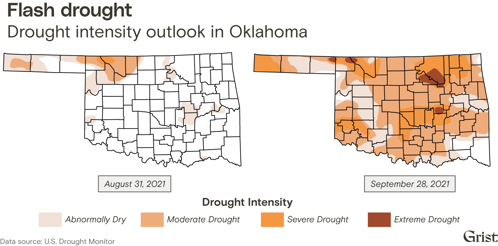
September in Oklahoma is typically a rainy season, when farmers take advantage of the state’s third-wettest month to plant winter wheat. But last year, many were caught off guard by abnormally dry weather that descended without warning. In the span of just three weeks, nearly three-quarters of the state began experiencing drought conditions, ranging from moderate to extreme.
Fast-moving droughts like this one are developing more and more quickly as climate change pushes temperatures to new extremes, recent research indicates — adding a new threat to the dangers of pests, flooding, and more long-term drought that farmers in the U.S. already face. Known as “flash droughts,” these dry periods can materialize in as quickly as five days, often devastating agricultural areas that aren’t prepared for them.
During last year’s drought in Oklahoma, Jonathan Conder, a meteorologist for a local news station in Oklahoma City, marveled at the speed and severity of the event. Tulsa, the state’s second-largest city, went 80 days without more than a quarter-inch of rain, while temperatures in southwestern Oklahoma climbed into the triple digits.
“This is huge for Oklahoma,” Conder said during his broadcast on October 1. “Our agricultural community, the farmers who plant wheat, they may not even be able to plant if they don’t get two inches of rain.”
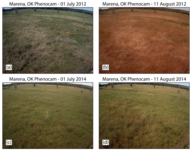
Flash droughts can dry out an area in the span of weeks. The top images show the impact of a flash drought in Oklahoma in 2012, compared to the same area two years later in the bottom row. Jeffrey Basara
The threshold for drought conditions differs by location, with the U.S. Drought Monitor using data on soil moisture, streamflow, and precipitation to categorize droughts by their severity. While typical droughts develop over months as precipitation gradually declines, flash droughts are characterized by a steep drop in rainfall, particularly during a season that normally receives plenty, along with high temperatures and fast winds that quickly dry out the soil. They can wither crops or prevent seeds from sprouting, delaying or diminishing the harvest.
Now, flash droughts are coming on faster and faster — making them more difficult to predict and more damaging, according to a recent study published in Nature Communications. The research, from scientists at the University of Texas and Hong Kong Polytechnic University, found that in the last 20 years, the percentage of flash droughts developing in under a week increased by more than 20 percent in the Central United States.
“There should be more attention paid to this phenomenon,” said Zong-Liang Yang, a geosciences professor at the University of Texas and one of the study’s co-authors, as well as “how to actually implement [these findings] into agricultural management.”
Scientists have long warned that warming temperatures and shifting rainfall patterns due to climate change pose a threat to the cash crops of the Midwest and Great Plains, primarily corn, wheat, and soybeans. But flash droughts are a relatively new area of research, Yang said, with the term gaining usage only in the last couple of decades.
The increase in their severity and frequency, though, is already being felt across the U.S. In 2012, a flash drought struck the Central U.S. in the middle of the growing season, causing an estimated $31.2 billion in crop losses. Another flash drought hit Montana, North Dakota, and South Dakota in the spring of 2017, leading to more than $2.6 billion in agricultural losses, along with “widespread wildfires, poor air quality, damaged ecosystems, and degraded mental health,” according to a study published in the Bulletin of the American Meteorological Society.
Flash droughts are also a global problem, with Brazil, India, and multiple countries in Africa facing the worst impacts. In 2010, a flash drought followed by a heatwave in Russia temporarily halted wheat exports, a major disruption for communities across the Middle East that depend on the country’s grain.
The damage flash droughts can cause depends on the crop and the time of year, said Dennis Todey, director of the Midwest Climate Hub for the U.S. Department of Agriculture. Corn is the most vulnerable during its pollination season in mid-summer, while soybeans are affected in August and wheat during planting season in the spring.
Drought is a natural part of the climate in this region, Todey said, particularly in the western part of the Corn Belt — a region that encompasses the Midwest and the Great Plains. Many farmers have learned to adapt and integrate dry conditions into their planting cycles. But what makes flash droughts so dangerous is their rapid onset, Todey said, leaving little time for agricultural producers to prepare.
“Drought most times is thought of as a slow-starting and then a slow-stopping event,” Todey said. “In a flash drought setting … instead of just starting to dry out gradually, you have surfaces that dry out very quickly, you have some newly planted crops that are starting to be stressed more quickly.”
Last September’s flash drought hit Oklahoma in a matter of weeks. Chad Small / Grist
Many farmers don’t know if they’re starting to experience a drought, though, until expected rains fail to appear. Rainfall in mid-October helped ease the flash drought that began in Oklahoma in September, but after that a much longer drought set in, said Keeff Felty, a fourth-generation wheat and cotton farmer in the southwestern part of the state. As a result, some of his crop never germinated, while his overall yield dropped when it came time for the harvest.
“There’s a lot of information out there, and you have to avail yourself of what works best for you, but you also have to be prepared for it to go totally south,” Felty said. “Nobody saw [the drought] coming, and it’s just a fact of the weather that we don’t have any control over it. It’s just life.”
Typical droughts can last months or even years — the western U.S. is currently experiencing its third decade of “megadrought” — while flash droughts can end more quickly, within weeks or months, Yang said. And they can hit in relatively wet areas, including the eastern part of the country, where drought conditions are much more rare than in the West.
The main reason they’re occurring faster, Yang said, is climate change. As the air warms, it can lead to more evaporation and dry out the soil. This can occur even in areas that can expect to receive more rainfall overall because of climate change, because scientists project that rainfall will be unevenly distributed — falling in more extreme events and making other parts of the year drier.
“Every [recent] decade we have seen is the warmest decade in history,” Yang said. And with the world on track to blow past a global temperature that’s 1.5 degrees Celsius (2.7 degrees Fahrenheit) higher than the pre-industrial average, he expects to see both flash droughts and longer droughts occurring more frequently.
Researchers are working on improving their models to better predict flash droughts, Yang said, with the help of new technologies such as more granular satellite monitoring and machine learning. The main marker they look for is high rates of evapotranspiration, when plants suck up water from the soil and then release it into the air through their leaves — a process that accelerates with high temperatures and winds and can be monitored with special cameras that detect fluorescence, or the heat emitted by plants.
If farmers can know when to anticipate a flash drought, Todey said, they can skip or delay planting, or reduce their fertilizer usage when they know a crop won’t grow. They can also adjust their planting schedule and take better care of their soil by minimizing tillage, which dries it out even more. But with less and less time to prepare for flash droughts, Todey said, some may have to make difficult choices about whether to plant at all.
“Agricultural producers naturally adapt to changing conditions,” Todey said. “But eventually there comes a point where [losses] become more frequent. People start going, ‘Okay, this isn’t working.’”
This story was originally published by Hakai Magazine and is reproduced here as part of the Climate Deskcollaboration.
Two kilometers inland from Hawke’s Bay on the North Island of New Zealand, a dark-red gate just off the highway marks the entrance to the Tangoio Marae. This marae is where a local Māori hapū, or community, holds regular gatherings and ceremonies. The location seems perfect: surrounded by lush green hills, close to the city of Napier, and just a stone’s throw from the ocean. But there is one problem: the marae is at very high risk of flooding. The hapū of Tangoio Marae have a serious decision to make about this place that is so central to their community, and one of their decision-making tools is unorthodox: a board game.
Called Marae-opoly, the Māori community designed the game in partnership with researchers from New Zealand’s National Institute of Water and Atmospheric Research, or NIWA, with the explicit goal of helping the hapū decide how to manage the flood risk to their marae. While the researchers from NIWA contributed scientific data about known flood risks and projected climate change effects, the hapū brought their own experiences and values to the table during game development brainstorming sessions.
“Brainstorming is really important,” says Paula Blackett, a social scientist at NIWA who co-designed Marae-opoly. “It allows people to express their thoughts on what could be done [to address the flood risk], and why. It’s quite an inclusive approach because you consider all of the different things that could be possible.”
A turn in Marae-opoly plays out in several steps. First, teams debate how to address the flood risk and choose to either make the marae more flood resistant by waterproofing buildings, raising the flood banks, or improving drainage works; move its location; or wait and save money. In each round, a random “rainmaker” event reflecting the real odds of extreme weather determines the rainfall for that decade. Sometimes the team is hit by a devastating flood, other times it is dry, but it is impossible to predict what will happen when. Turns go on like this until players have experienced 100 years of climate change, with the decisions they made early on compounding over time.
Once the game was ready to play, several dozen of the hapū gathered at their marae to spend a Saturday playing. It was a lively event, with teams debating their choices each turn.
“Although it was a safe environment, it actually made people realize that whatever decision they made there will be consequences,” says Tania Hopmans, chair of the Maungaharuru-Tangitū Trust, which represents the hapū of Tangoio Marae. For example, investing money early in the game to save for larger expenses could leave them at risk of higher costs due to flood damage, but spending a small amount could mean insufficient protection against bigger floods.
Games like Marae-opoly are what researchers refer to as serious games — games designed for a specific educational purpose. NIWA has been using serious games for a few years as a way for people to better understand the risks of climate change.
“Most people struggle with being able to integrate all of the different streams of information that they need in order to make robust climate change adaptation decisions in an unknown future,” says Blackett. Games make that kind of information more manageable and let people experience it at a small scale.
In the past few years, board games have been used around the world to teach a wide range of topics, from medical skills to cultural history and more. Like Marae-opoly, games can be used to model real-world environmental scenarios. For example, Azteca Chess helped Mexican coffee farmers make decisions about pest control.
According to Rebecca Bayeck, an expert on the educational value of games at Utah State University who was not involved in the Marae-opoly project, board games have inherent qualities that make them suitable learning environments. “Collaboration, mathematical thinking, computational thinking — all these skills that you will need in the 21st century — are actually found in board gaming.”
Even commercially designed games can be used educationally. For example, Pandemic, a board game in which players work together to stop the global outbreak of several infectious diseases, has been used to teach group decision-making. Recently, the game received new interest during the COVID-19 pandemic as a casual way to understand the complexity of what was happening in the world.
But why board games? Unlike video games, Bayeck sees board games as fostering a welcoming space because they facilitate in-person connections. Playing the game “invites personal interaction where you can see the face of the other [players], see their expression, ask a question,” she says.
The casual setting of playing Marae-opoly allowed the hapū to openly have difficult discussions about their options — to either stay and defend the marae from oncoming floods, or move the cultural and spiritual hub of their community.
By playing the game, Hopmans says, “people can have great arguments at the table about what to do or what not to do, and the consequences came five minutes later.”
Besides facilitating debates, the game also clarified complex concepts. “One of the things that has really stood out for me is how people think about and process risks,” says Blackett.
For instance, the type of flood that is of particular danger in New Zealand is often referred to as a 100-year flood, which makes it sound unlikely to happen any time soon. The reality is that every year has an equal chance of seeing a 100-year flood, and it’s possible to get two 100-year floods back to back. Climate change is also making these extreme floods more likely.
Marae-opoly helped the Māori community of Tangoio Marae better assess the risk to their meeting place and how their actions affected possible outcomes. It was a low-stakes trial for an important decision — and after weighing all the options, the community made their decision for real. “We’re moving the marae,” says Hopmans.
Through a stroke of luck, a local farm recently sold them a patch of land just 300 meters away from the marae’s current site, on slightly higher ground. “Over time, we still may need to move further,” cautions Hopmans, as the floods may eventually catch up with the new site. But, she adds, “at this point, we are definitely moving up the road.”
Moving a site of such cultural and spiritual significance was a tough decision, with real people and real money at stake. But playing a board game made it a bit easier to process.
Recently, a group of national security and environmental experts, including former Environmental Protection Agency Administrator Christine Todd Whitman, former Occupational Safety and Health Administration head David Michaels, and retired United States Army Generals Russel Honoré and Randy Manner, wrote to EPA Administrator Michael Regan.
They urged the agency to issue stronger and stricter regulations to protect Americans from chemical accidents that may be caused by natural disasters, among other factors. These natural disasters are more and more frequently the result of climate change, which is escalating decade by decade. As a global phenomenon with frightening environmental implications happening right before our very eyes, climate change is primarily the consequence of destructive, reckless human activity such as burning fossil fuels and cutting down forests.
On February 2, Kathleen Salyer, director of EPA’s Office of Emergency Management, responded to the experts’ letter, saying the “EPA will consider the points made” and that “the EPA is considering improvements to the rule to better address the impacts of climate change on facility safety and protect communities from chemical accidents, especially vulnerable and overburdened communities living near [risk management plan (RMP)] facilities.”
The RMP rule requires facilities that store hazardous substances to have emergency responses in place in the event of a chemical accident. On May 26, the EPA announced that two virtual public listening sessions will be held on the agency’s RMP rule. These sessions will offer interested people the opportunity to present information and provide comments with regard to the revisions made to the RMP rule since 2017.
“These listening sessions are a first step in considering improvements to the RMP rule, so EPA can better address the impacts of climate change on facility safety and protect communities from chemical accidents, especially vulnerable and overburdened communities living near RMP facilities,” said Carlton Waterhouse, who is the EPA deputy assistant administrator for the Office of Land and Emergency Management. Preventing natural disasters from striking chemical facilities should be a priority for the EPA, as oftentimes, these incidents lead to hazardous substance leaks that reach the vulnerable nearby communities. As a consequence of climate change, carbon dioxide from human activity is increasing 250 times faster than it did from natural sources after the last ice age. Furthermore, the most catastrophic hurricanes are three times more frequent than 100 years ago, and the proportion of major hurricanes has doubled since 1980.
How Many Chemical Facilities Are at Risk of Being Struck by a Natural Disaster?
Right now, there are 872 chemical facilities storing highly hazardous substances within 50 miles of the U.S. Gulf Coast, where hurricanes occur quite frequently. Over 4.3 million people, as well as 1,717 schools and 98 medical facilities, are located within 1.5 miles of these chemical facilities. However, across the country, there are 10,420 RMP facilities, from which more than 3,200 are at risk of releasing hazardous substances into the environment in the event of a chemical accident triggered by extreme weather phenomena. These climate change-fueled events pose a tremendous danger to these facilities, as hurricanes and flooding can easily lead to the release of toxic substances among communities living nearby.
While this should be seen as a very serious, acute issue, policy makers remain passive and have failed to take action to strengthen the lax rules that currently govern these facilities. What is perhaps the saddest thing is that they have failed to learn from past tragedies, such as Hurricane Harvey, which struck Galveston and Houston, two cities in Texas, in 2017.
The aftermath of the toxic flooding was heart-wrenching — 88 victims and thousands of families were left without a home. More than 650 chemical facilities in Texas were at risk of releasing hazardous substances due to the flooding, and approximately 100 chemical and oil leaks were reported following the hurricane. Some of the most dangerous chemicals facilities can accidentally release, either from aboveground or underground tanks, during a natural disaster include poisons, flammable liquids, dioxins, corrosives, heavy metals and oxidizers. More specific examples include benzene, cadmium oxide, chloroform, ethylene oxide, lewisite, mercuric acetate, nitric acid, paraquat and tabun.
At the moment, private law governs chemical facilities across the U.S. Private law concerns a particular individual or small group, including certain industries, whereas public law refers to rules for general application, such as those enforced for the nation as a whole. Nevertheless, existing private law mechanisms such as tort liability do nothing to prevent catastrophes such as Hurricane Harvey.
A viable alternative to private law is public law, which would enforce regulations and performance standards for chemical storage and additional reforms to close the gaps in the management of facilities that store hazardous chemicals nationwide.
Private Law Fails to Protect Vulnerable Communities
Insurance, tort law and contractual arrangements cannot properly address the sinister threat of hazardous substance leaks because it is very difficult to identify the firms that are the sources of these spills and hold the companies accountable for negligence. Moreover, the existing regime dates back to the 1970s. It was developed for a different time, and it reflects different priorities, which is why it is no longer effective.
Policy makers should not assume that present weather conditions or the physical infrastructure of chemical facilities will remain the same, so they must build adaptability and resilience into emergency planning scenarios. Similarly, they should not assume that chemical facilities that have not experienced a hazardous substance leak in the past will not have to deal with one in the future. Because chemical facilities may not face liability for the harm they cause, private law is very unlikely to effectively manage the problem of toxic exposure stemming from extreme weather events caused by climate change.
For many decades, the U.S. has relied on private law governing industrial chemical storage. Still, there are no mandatory standards for storage tank performance, inspections, record-keeping or setback requirements. There are no Federal Emergency Management Agency regulations governing chemical storage either. This lack of regulations causes private firms to store millions of gallons of hazardous substances in areas prone to natural disasters without regulatory oversight of their storage practices or extreme weather preparedness.
Public Law Would Help Solve the Issue of Chemical Disasters
The government and private sector are neglecting the danger of natural disasters caused by climate-fueled extreme weather events striking chemical facilities. The Trump administration prevented the Chemical Safety Board from taking measures and weakened the few federal regulations concerning chemical disaster prevention. As a result, the chemical industry is failing to secure hazardous materials against superfloods, which will occur more and more often as the planet warms.
Policy makers should cease seeing natural disasters as unrelated events and learn valuable lessons from extreme weather phenomena management to respond better to such crises in the future. Since private law failed, the U.S. needs public law efforts to prevent disasters, such as regulations and performance standards for chemical storage and other reforms to close the gaps in outdated toxic-chemical management statutes. Authorities should reduce the vulnerability of communities living near chemical plants, and the federal government should strengthen the existing chemical regulatory regime to become more responsive to climate change events.
Congress and the EPA should close these gaps by requiring improved standards for chemical storage, restrictions on siting, inspections of vulnerable facilities, and reforms to the Emergency Planning and Community Right-to-Know Act. As a first step, policy makers and emergency managers should make a comprehensive inventory of vulnerable chemical plants. They should also have a full understanding of the hazardous substances stored in each and the facility’s degree of exposure to natural disasters.
To have a foolproof tool for natural disaster prevention, Congress should take two steps. First, it should increase federal funding for local emergency planning committees so that these committees can fulfill their emergency planning tasks. These committees bring together elected officials, police and fire departments to prepare and implement emergency response plans. Secondly, Congress should amend the Emergency Planning and Community Right-to-Know Act to impose construction, siting and performance standards for the storage of hazardous chemicals above a certain volume threshold.
Although climate change is inevitable and worsening with each passing decade, there are numerous feasible and effective measures policy makers can enforce to prevent exposing residents living near chemical facilities to toxic substances that could escape these plants. By collaborating with experts and various authorities, they can develop strong emergency responses that would keep these vulnerable communities safe at all times.
Even as President Biden’s signature climate change bill languishes in the Senate, Congress is poised to spend billions of dollars on ambitious new projects that would help the U.S. adapt to climate change. A bill that would authorize the Army Corps of Engineers to build infrastructure to protect against climate impacts is quietly sailing through Congress, demonstrating bipartisan support for measures to protect against flooding and sea-level rise. Lawmakers may not be willing to pass laws that will dramatically cut carbon emissions, but they appear eager to fund projects that will mitigate the harms those emissions cause.
Established in the nineteenth century, the Corps is a public-works authority charged with protecting the nation’s rivers and beaches from flooding and erosion. It has a mixedrecord on bothfronts: Its levees have sometimes failed disastrously during storms like Hurricane Katrina, and its erosion control projects have often failed to slow down beach disappearance. To set the agency’s agenda, Congress reauthorizes a law called the Water Resources Development Act in every legislative session. Usually that just involves giving it money for various river control projects and authorizing it to conduct studies on the viability of future projects.
This year’s bill, however, seeks to give the Army Corps of Engineers a heftier role in responding to the effects of climate change, even though it doesn’t name them as such. The legislation will authorize funding for several massive projects in parts of the country hardest hit by climate change, and it also expands the range of issues the agency can tackle to include shoreline resilience and drought. The bill cleared a Senate committee last week on a unanimous vote, and the House of Representatives will soon mark up its own version.
The marquee projects in the new bill seek to protect communities along the Gulf of Mexico from storm surge and flooding. Hurricanes and tropical cyclones have become stronger and more destructive as the oceans have warmed, and rapid sea level rise has made flooding more common all along the coast. Congress’s decision to address these threats amounts to a tacit admission that climate change has ratcheted up the danger.
The centerpiece of the bill is a $19 billion allocation for the “Coastal Texas Protection and Restoration” project, better known as the “Ike Dike.” This long-awaited initiative aims to protect Houston from devastating storm surges by constructing a massive sea wall system along the Bay of Galveston. The centerpiece of the system would be a set of 15 interlocking gates, the largest ones 22 feet high, that could slam shut during hurricane events. This would stop storm surges from pushing through the ship channel and into Houston, as happened during Hurricane Ike in 2008. The project would be one of the largest ever undertaken by the Corps, and it accounts for well over half the bill’s overall spending.
The bill also includes funding for another massive levee structure in Louisiana. The $1 billion Upper Barataria Basin project would stretch across 30 miles and seven parishes, bringing a new level of storm surge protection to the section of Louisiana known as “Cancer Alley.” Last year’s Hurricane Ida brought devastating flooding to many of these same areas, overtopping minor levees in towns like LaPlace, but the expanded levees should keep them safe from all but the largest storms. These levees have become all the more necessary as coastal erosion has erased much of Louisiana’s marshland, which previously acted as a natural barrier against flooding.
Around $1 billion will head to the Florida Keys, where the Corps can use it to elevate almost 5,000 homes along the archipelago of islands, where sea levels have risen around four inches since the turn of the century. The agency considered devoting the money to home buyouts, but it ultimately decided the buyouts wouldn’t be cost-effective in the Keys. Elsewhere in the country, though, the Corps has sought to buy out hundreds of homes, even telling some localities that it wanted them to use eminent domain to force people out of vulnerable areas.
In addition, the bill authorizes the Army Corps of Engineers to play a larger role in tackling climate-change-related phenomena like drought and coastal erosion. The agency already spends a lot of money on jetties and seawalls to stall erosion in places like New York City’s Rockaway Beach, but legislators are now mandating that Corps projects “shall be formulated to increase the resilience of such shore[lines] and [river]banks from the damaging impacts of extreme weather events and other factors.”
Rather than just dumping new sand on a beach that’s eroded, the Corps will have to consider how it could make that beach more resilient to future erosion, for instance by installing so-called living shorelines. The bill also allows the Corps to undertake drought response efforts in the West, a provision secured by Senator Mark Kelly of Arizona, whose state is experiencing an unprecedented drought that has been enhanced by climate change.
These new responsibilities fall outside the historical mandate of the Army Corps of Engineers, indicating that lawmakers want to turn the agency into a kind of Swiss army knife for climate adaptation. The notion of a civilian climate corps might be dead, but the non-civilian Corps is taking on a larger burden than ever when it comes to federal climate policy. Something similar is happening at the Federal Emergency Management Agency, where lawmakers allocated billions of dollars for climate resilience and buyouts.
Still, even the biggest projects in the new Water Resources Development Act are little more than Band-Aids in the context of the nation’s vulnerability to floods and fires, and the bill does nothing to reduce the carbon emissions that increase this vulnerability. Nevertheless, the bill shows that climate adaptation remains palatable even to Republican politicians who answer to conservative voters. These politicians may not want to subsidize clean energy or reduce fossil fuel usage, but they have every incentive to dole out money for large capital projects in their states, and to show their constituents they’re helping make them safer.
An early-season blaze has turned into New Mexico’s second-largest on record, torching more than 165,000 acres. And the Calf Canyon fire, the biggest burning in the United States, is one of six wildfires in New Mexico right now, a worrying start to what’s expected to be an unusually intense wildfire season in the West.
President Joe Biden declared a “major disaster” for the state on Wednesday, offering federal resources to help with recovery efforts. East of Santa Fe, the Calf Canyon fire has burned hundreds of buildings and prompted the evacuation of 6,000 homes. Evacuees left behind goats, rabbits, and dogs, while those who took pets with them struggled to find places to stay.
It’s been an abnormally fiery spring in the United States, with fires burning across Florida, Texas, and Colorado in March. As of early May, wildfires had already torched 1.1 million acres in the U.S., double that of the same time last year.
The fires in New Mexico are being fueled by wicked winds as well as searing drought and warmer than average temperatures exacerbated by climate change. A megadrought is currently plaguing the Southwest, a region that is experiencing its driest period in 1,200 years. So it should not come as a surprise that this year’s wildfire season is promising to be another ferocious one.
A forecast released from AccuWeather on Wednesday predicts above-normal wildfire activity for the western United States, exacerbated by hot temperatures and a dry winter. Some relief may come from La Niña patterns this summer, which will bring monsoon rains — but also lightning strikes, potentially igniting more infernos.
Climate change has amped up fires in recent years, with arid conditions and hot temperatures scorching vegetation and fueling ones that burn hotter and longer. The number of blazes that burn around the world could rise 50 percent by the end of the century, according to a report from the United Nations Environment Programme in February.
The Calf Canyon fire in New Mexico is the largest blaze the country has seen so far this year. Last week, it merged with the Hermits Peak fire, and as it grows, it could threaten 15,000 homes. The region at risk in northern New Mexico is home to descendants of Spanish settlers and Indigenous people who have lived in the mountains for centuries.
The state’s largest fire occurred in 2012, when the Whitewater-Baldy fire torched close to 300,000 acres. In New Mexico as a whole, roughly that same amount of land has gone up in flames this year — more than the last two years combined.
“We’ve already burned more acreage than we do on average for an entire season, and it’s now just the first week of May,” Brian Guyer, a meteorologist at the Weather Service office in Albuquerque, told the Washington Post. “Usually our biggest fires are in May and early June.”
This storywas originally published by the Guardian and is reproduced here as part of theClimate Deskcollaboration.
Global heating is causing such a drastic change to the world’s oceans that it risks a mass extinction event of marine species that rivals anything that’s happened in the Earth’s history over tens of millions of years, new research has warned.
Accelerating climate change is causing a “profound” impact on ocean ecosystems that is “driving extinction risk higher and marine biological richness lower than has been seen in Earth’s history for the past tens of millions of years,” according to the study.
The world’s seawater is steadily climbing in temperature due to the extra heat produced from the burning of fossil fuels, while oxygen levels in the ocean are plunging and the water is acidifying from the soaking up of carbon dioxide from the atmosphere.
This means the oceans are overheated, increasingly gasping for breath – the volume of ocean waters completely depleted of oxygen has quadrupled since the 1960s – and becoming more hostile to life. Aquatic creatures such as clams, mussels, and shrimp are unable to properly form shells due to the acidification of seawater.
All of this means the planet could slip into a “mass extinction rivaling those in Earth’s past,” states the new research, published in Science. The pressures of rising heat and loss of oxygen are, researchers said, uncomfortably reminiscent of the mass extinction event that occurred at the end of the Permian period about 250 million years ago. This cataclysm, known as the “great dying,” led to the demise of up to 96 percent of the planet’s marine animals.
“Even if the magnitude of species loss is not the same level as this, the mechanism of the species loss would be the same,” said Justin Penn, a climate scientist at Princeton University who co-authored the new research.
“The future of life in the oceans rests strongly on what we decide to do with greenhouse gasses today. There are two vastly different oceans we could be seeing, one devoid of a lot of life we see today, depending on what we see with CO2 emissions moving forward.”
Truly catastrophic extinction levels may be reached should the world emit planet-heating gasses in an unrestrained way, leading to more than 4 degrees Celsius of average warming above pre-industrial times by the end of this century, the research found. This would trigger extinctions that would reshape ocean life for several more centuries as temperatures continue to climb.
But even in the better case scenarios, the world is still set to lose a significant chunk of its marine life. At 2 degrees C of heating above the pre-industrial norm, which is forecast as likely even under current climate pledges by the world’s governments, around 4 percent of the roughly 2 million species in the oceans will be wiped out.
Fish and marine mammals that live in polar regions are most vulnerable, according to the study, as they will be unable to migrate to suitably cooler climes, unlike tropical species. “They will just have nowhere to go,” said Penn.
The threat of climate change is amplifying the other major dangers faced by aquatic life, such as overfishing and pollution. Between 10 percent and 15 percent of marine species are already at risk of extinction because of these various threats, the study found, drawing upon International Union for Conservation of Nature data.
John Bruno, a marine ecologist at the University of North Carolina who was not involved in the study, said the new research appeared “sound” but it differed from previous studies on the topic that suggest species will mainly disperse to new areas rather than be completely snuffed out.
“It’s very different from what most prior work has developed. But that doesn’t mean they are wrong,” Bruno said. “I think this new work is challenging some of our current assumptions about the geographic patterns of looming extinction in the ocean.”
Bruno said that while mass extinctions are likely from extreme heating in the future, the current impacts from climate change and other threats should be concerning enough for policymakers and the public.
“Personally, I’m a lot more worried about the ecosystem degradation we’re already seeing after less than 1 degrees Celsius of warming,” he said.
“We don’t need to look to a world so warmed over humanity has been wiped out – we’re already losing untold biodiversity and ecosystem functioning with even the relatively modest warming of the last 50 years.”
A record-shattering heat wave is devastating parts of India and Pakistan, putting more than a billion people at risk and unleashing a surge of related problems. For decades, experts have warned that climate change would make heat waves like this more frequent and more intense — a prediction now playing out in real time.
Last month, northwest and central India experienced the hottest April since record-keeping began 122 years ago. On May 1, the temperature in Nawabshah, Pakistan, climbed to 121.1 degrees Fahrenheit, likely the hottest temperature recorded so far this year in the northern hemisphere. Other cities and towns across the region also suffered through record-breaking temperatures.
“This heatwave is definitely unprecedented,” Chandni Singh, a lead author for the Intergovernmental Panel on Climate Change, or IPCC, and a senior researcher at the Indian Institute for Human Settlements, told CNN. “We have seen a change in its intensity, its arrival time, and duration. This is what climate experts predicted and it will have cascading impacts on health.”
In the western Indian state of Gujarat, “we are getting many patients who have suffered heat stroke or other heat-related problems,” Mona Desai, former president of Ahmedabad Medical Association, told Reuters. She said that more than half of the patients were children — an age group particularly vulnerable to extreme heat — who were experiencing vomiting, diarrhea, abdominal issues, weakness, and other symptoms.
Early reports indicate 25 people have died of heatstroke in Maharashtra, a state in western India, since late March. The true toll across the region will likely be much higher; a recent study found that over the past 50 years heatwaves have killed over 17,000 people across the country. “This heatwave is testing the limits of human survivability,” Singh told CNN.
In some parts of India the demand for electricity has spiked, leading to widespread power outages. CNN reported that three out of five of Delhi’s power plants were critically low on coal last week, and that the country has canceled hundreds of passenger trains in a scramble to clear the tracks and expedite coal shipments.
The extreme heat has decimated agricultural areas, reducing yield from wheat crops by up to 50 percent in some areas and killing off nearly all fruit harvests in others. “We don’t know what to do,” Haji Ghulam Sarwar Shahwani, a farmer who grows apples, told The Guardian. “Farmers have lost billions because of this weather. We are suffering and we can’t afford it.”
In Pakistan, Sherry Rehman, the country’s minister for climate change, warned that glaciers in the northern region were melting quickly, and that flash floods caused by glacial lake outbursts could wreak havoc on mountain communities.
Disasters exacerbated by climate change are making life for over a billion people in India and Pakistan extremely challenging, though they have done little to cause the global problem. India and Pakistan are responsible for only a sliver of cumulative greenhouse gas emissions — about 3.4 percent and .7 percent, respectively. In recent years, India has emerged as a super-emitter due to its heavy reliance on coal, but its per capita emissions are less than 2 metric tons per year. (The U.S.’s per capita emissions are over 15 metric tons per year.)
The most recent IPCC report warned that the world must make “rapid and deep” cuts to emissions — achievable only if we immediately phase out fossil fuels — in order to stave off even worse consequences of climate change. Rehman told The Guardian that she hopes this deadly heat wave will serve as a wake-up call. “Climate and weather events are here to stay and will in fact only accelerate in their scale and intensity if global leaders don’t act now,” she said.
Another climate disaster in the Southern Africa region has taken place over the last two weeks in the KwaZulu-Natal Province (KZN), where the important port city of Durban is located.
Official reports from the South African government says that several hundred people have been killed due to the flooding while tens of thousands of others have been dislocated and in drastic need of humanitarian assistance.
The government of President Cyril Ramaphosa and the parliament has declared a state of disaster in response to the flooding. The South African National Defense Forces (SANDF) has announced that it is deploying up to 10,000 troops to assist in the relief and rescue operations.
These floods come in the aftermath of a series of other weather events which have been attributed to climate change.
Earlier this month, as water levels in the Lake Powell reservoir fell to record lows amid the ongoing Western drought, the federal government asked seven states that rely on the Colorado River to work out an emergency conservation deal. The states had been scheduled to receive river water that was stored in the lake, but releasing the water would have drained the reservoir further, threatening its ability to generate hydroelectric power for millions of people and raising utility bills for towns and tribes across the West. The feds also revealed that declining reservoir levels would endanger the tubes that carry water past the dam’s hydropower turbine, potentially depriving multiple communities of drinking water and compromising “public health and safety.”
Late last week, the states agreed to forfeit their water from Lake Powell in order to ensure that the reservoir can still produce power. The deal puts a finger in the metaphorical dike, postponing an inevitable reckoning with the years-long drought that has parched the Colorado River — and a wrenching tradeoff between power access and water access for millions. It does so, in part, through an unusual act of hydrological accounting.
The deal has two parts. The first and more straightforward part is that the federal government will move 500,000 acre-feet of water (about 162 billion gallons) from the Flaming Gorge Reservoir into Lake Powell, bumping up water levels in the latter body. Flaming Gorge, which stretches across Wyoming and Utah, is mostly used for water recreation, so the immediate effects of the transfer will be minimal. The feds could do more of these water transfers later in the year if things get worse, drawing on water from other nearby reservoirs.
The second part is more complicated — and less helpful. In ordinary circumstances, the Bureau of Reclamation releases water from Lake Powell into an even larger reservoir called Lake Mead, from which it then flows to households and farms across the Southwest. As part of the deal, the states that rely on Mead water are agreeing to leave about 480,000 acre-feet of that water in Lake Powell, thus lowering the water levels in Mead. (Reclamation already announced earlier this year that it would delay the release of 350,000 acre-feet of water in Powell in anticipation of spring snow runoff.)
The problem is that Lake Mead’s falling water level has huge implications for water access in the Southwest. Pursuant to a drought contingency plan worked out back in 2019, declines in Mead trigger mandatory water reductions for states like Nevada and Arizona. The first of these reductions arrived last year, when the river entered a so-called “Tier 1” shortage, resulting in a 30 percent cut to Arizona’s water allocation. This has forced farmers in the Phoenix area to fallow their cotton and alfalfa fields. Officials expect the river to enter a Tier 2a or 2b shortage in the coming years, which would mean even larger cuts. Keeping water in Lake Powell makes it more likely the reservoir will reach that threshold.
The deal contains an eyebrow-raising workaround for this. In exchange for leaving the water in Lake Powell rather than having it flow to Lake Mead, the states get something in return: Officials at the Bureau of Reclamation will act as if that the water did go to Mead, thus treating Mead’s water level as though it’s higher than it really is. The hope here is to avoid triggering the cuts that would accompany a Tier 2b shortage declaration, even though the actual water level in the reservoir will likely fall low enough to warrant such cuts.
Grist / Amelia Bates
In other words, the states have agreed to ensure Lake Powell has more water than it should, and in return they get to pretend as though Lake Mead has more water than it does. The deal protects the towns and tribal communities that rely on Powell for water, but only for a short time: The ongoing drought has shown no signs of letting up, and it’s only a matter of time before water levels in Powell fall back into the danger zone, jeopardizing hydropower access and drinking water quality.
The Bureau of Reclamation did not respond to Grist’s requests for comment. An announcement confirming the agreement is expected later this week.
For the millions of people who rely on Lake Mead, meanwhile, the deal just postpones a shortage declaration that was bound to arrive in a few years anyway. It may give states like Arizona more time to figure out how to cope with declining water allotments, but it won’t stop cotton fields from going fallow or absolve suburbs like Scottsdale of the need to drastically reduce their water usage.
For as long as there’s a drought on the Colorado, federal officials will have to choose between hydroelectric power in communities that depend on Lake Powell and water access in those that rely on Lake Mead. The sudden advent of this new short-term deal shows not only that these decisions are not going away, but that they will arrive faster than any of the parties on the river ever thought they would.
This storywas originally published by Mother Jones and is reproduced here as part of theClimate Deskcollaboration.
At 5:30 p.m., December 10 of last year, they heard the unmistakable wail of tornado sirens. Some of the workers crafting cinnamon, pumpkin spice, and vanilla candles asked to go home: Western Kentucky’s Mayfield Consumer Products plant, with its vulnerable wide-span roof, was the kind of building to avoid in a storm.
Staff were first told to shelter in a hallway. But they were soon ordered back to the factory floor to finish their ten-hour shifts. Leave, managers warned, and you’re fired. The threat worked.
Just after 9 p.m., the sirens wailed again. The tornado obliterated the Mayfield plant. Eight workers died.
Mayfield’s management, according to a survivors’ class-action suit, was aware of the danger — forecasters had been predicting major tornadoes all week — and had rejected a request by floor supervisors to stop work for the day. But the firm’s other plant, just six miles away, did shut down for the storm. The difference? The first factory was working overtime to ship candles for the lucrative Christmas rush.
The company now faces a state investigation, but it doesn’t have much reason to worry: thanks to weak state and federal worker protections, companies responsible for on-the-job deaths pay an average fine of $12,000. That’s if the laws are enforced — a 2019 federal audit found that Kentucky “failed to properly investigate nearly every single worksite death” in a two-year period, and its safety record’s far from the worst.
In theory, federal laws demand a “safe and healthful” workplace, with a rulebook to cover the details: Too windy? Your boss can’t make you work on tall scaffolding. Handling live wires? You’re entitled to good safety gear. But no rule or law kept Mayfield from packing the factory floor throughout what Governor Andy Beshear called the “strongest set of tornadoes” in Kentucky’s history.
Those workers weren’t alone in risking their lives for their jobs — far from it. Runaway climate change is making extreme weather more common and deadly, bringing new dangers to work we’ve thought of as safe. Twisters are striking in new territory and throughout more of the year, especially in the Midwest and Southeast. That’s also true for flood-level rains, which adds hazards to ordinary commutes, let alone trucking or car-based gig work. Full-time drivers have to weigh those risks against hungry kids or the threat of eviction — a section missing from the DoorDash manual. Further west, wildfires are driving extreme air pollution, a killer for the millions of Americans who work outdoors. And for workers everywhere from Big Ag to Amazon, longer, hotter summers are already costing lives.
That’s where the Occupational Safety and Health Administration, or OSHA, the country’s chronically underfunded workplace watchdog, is supposed to come in. OSHA writes, enforces, and (ideally) revises that nationwide job-safety rulebook. But since its inception in 1971, it’s been subjected to right-wing legislative, fiscal, and PR assaults, with workers’ lives in the balance. It has fewer than 1,000 inspectors to monitor some 10 million worksites. Its new rules need Congress’ approval, making them easy to gut or kill and keeping it far behind the times. And, crucially, the agency was chartered almost 20 years before the first Congressional hearing on climate change. Deeply unequipped for an age of climate disaster, OSHA is leaving workers to ride out the storm on their own.
Tornadoes, immediate and terrifying, tend to make the news. But for the typical worker, climate chaos’ most likely — and insidious — threat is harder to see: heat. The past seven years have each been the hottest on record, and recent summer heat waves have broken records as well. It’s especially dire in regions less used to extreme heat, like the Pacific Northwest, where last year’s unprecedented hot spells claimed hundreds of lives. In its current state, OSHA is particularly badly prepared for a long-term uptick in heat. In fact, the agency doesn’t have heat regulations. Companies aren’t required to provide extra breaks or accommodations for extreme heat (although there is a water standard). As death tolls soar — three decades ago, heat was half as likely to be the reason for an on-the-job death — the agency has actually cut down on excessive heat investigations.
In fairness, after summer 2021’s heat waves caused a record number of deaths, President Biden’s OSHA started on a federal heat standard — though it could take years to craft and would unquestionably die in a Republican Congress. Under another Biden initiative, the agency must now prioritize workplace inspections when daily temperatures exceed 80 degrees Fahrenheit.
In this aerial view, crews clear the rubble at the Mayfield Consumer Products candle factory after it was destroyed by a tornado three days prior on December 13, 2021. Scott Olson / Getty Images
In a statement, OSHA assistant secretary Doug Parker said the agency is “taking several measures to protect workers better in hot environments and reduce the dangers of exposure to ambient heat,” calling heat safety a “top priority.” Parker pointed to an enforcement initiative on heat-related hazards and a variety of advisory campaigns, such as one appealing to employers to “engage their workers, listen to their ideas.” The heat rule in the works, Parker says, would provide a “longer-term solution,” providing “additional tools to enforce requirements,” albeit within the strict limits current law imposes on new work-safety rules.
Other problems still plague the agency. In 2020, with Covid pushing OSHA complaints to record highs, the agency counted 862 investigators — fewer than it had in 1975, when it dealt with a third of its current workload. In 2019, late in the Trump administration, the number hit an all-time low: 752 inspectors for 130 million workers.
That makes inspections rare and compliance tough to enforce, especially when OSHA faces high-powered corporate appeals and objections. Penalties are often bargained down by employers who promise to remedy the situation or take a work-safety class. That’s been true since before OSHA existed: near the end of the Congressional fight over the bill that established the agency, the Senate passed a version that could have saved the Mayfield workers and countless others. OSHA, via the Labor Department, would have been able to shut down facilities where workers were in imminent danger. A factory forcing overtime amid massive tornadoes would have been an obvious target. But an eleventh-hour push by House conservatives stripped that power from the final bill, denying millions of workers a lifeline. There’s no better example of what OSHA could have been — and could become.
Even if the agency had an army of inspectors, serious violations, like failing to report a string of injuries, cost companies less than $15,000. Only “willful or repeated” violations hit six figures, capping at just over $145,000. Congress also bars OSHA from raising its penalties by more than 50 percent per year, making it practically impossible to ever set fines that would worry corporations like Amazon. Those are amounts, says National Employment Law Project analyst Anastasia Christman, that “bigger businesses can simply put into the calculations as a cost of business.”
In Mayfield’s case, the Kentucky Center for Investigative Reporting found that the company had been charged with seven serious safety violations in 2019 alone. The company contested them all. And while OSHA has tornado recommendations, they’re just that — recommendations, like its heat guidelines.
As Covid-19 rippled across the country, OSHA again gave employers non-binding safety suggestions, though it could have issued six- month emergency rules. A federal audit found that OSHA conducted half as many investigations in 2020 as in 2019, despite spiking complaints of inadequate PPE, zero social distancing, and major virus outbreaks at job sites. When OSHA did order inspections, the audit found, they weren’t conducted onsite — raising concerns that major hazards, Covid-related or not, were going undetected. All that as Covid killed hundreds of thousands of Americans, from meatpacking workers and their families to fruit pickers to postal workers. We don’t know how many people an agency with better protections, support, and staffing could have saved. But we do know that climate change won’t be any gentler.
And as with Covid, it’s low-wage workers, often workers of color, who bear the brunt. On the typical Amazon warehouse floor, three out of four workers are nonwhite. In 2019, when wildfires threatened Brentwood, Los Angeles — where the average house runs more than $2 million — numerous homeowners evacuated without a word to housekeepers and gardeners, many of whom still showed up to work. (85 percent of Brentwood homeowners are white; most of their household workers hail from Mexico and Guatemala.) In the last decade, a third of workers killed by heat were Latino, twice their proportion of the workforce. And at wages of $8 to $11 an hour, few Mayfield workers could have stayed home as long as the plant stayed open.
Last year, for a moment, OSHA’s future looked brighter. Adding workplace inspectors was a Biden campaign promise, and its 2022 budget rose by just over 10 percent — not enough for a real overhaul, but a start. (Congress, to its credit, also stymied Donald Trump’s attempts to slash that budget.) And the House version of Democrats’ Build Back Better Act promised the agency a 20 percent funding boost over five years, with which it could update standards, recruit inspectors, and manage whistleblower investigations. It would also have significantly raised penalties for major safety breaches: $70,000 for a serious violation, and more than 10 times that for serious and repeated ones. But the bill is now dead, and OSHA remains defanged.
Workers like Mayfield’s are invisible from Capitol Hill, where climate change and labor law feel less like issues of life and death. One survivor of the storm, 21-year-old McKayla Emery, had come in early for her night shift that Friday; she was pushing to hit Mayfield’s Christmastime minimum of 50 hours per week. When the tornado decimated the building, Emery spent six and a half hours pinned beneath rubble, comforting a dying friend the whole time. Scars and deep nerve damage now run along her whole body.
Like many at the plant, Emery was a temp. She’d started less than three weeks before the disaster, putting her worker’s compensation at $270 a week — hardly enough to pay the bills. For some survivors, she says, it’s even less. Each new treatment puts her through an arduous process with her insurer. Many involve a 5-hour round trip to specialists in Nashville.
“I’m really just struggling financially, on top of the mental and physical,” she told me. She says she’s grateful for community members’ support — rides to the doctor, help paying her bills — despite their own devastating losses. I asked whether her former employer could have done anything to help. “Girl,” she said, “they could have just told us not to come in to work.”
Two years ago, Chris Dailey decided he wanted to live higher up off the ground. Dailey, 53, had lived in the Shore Acres neighborhood of St. Petersburg, Florida, for almost 30 years. His house had almost flooded four times during that span. Plus, Dailey’s flood insurance costs were steep: He was paying $2,000 a year to purchase insurance from the Federal Emergency Management Agency, or FEMA.
Dailey bought a lot down the street, farther from the water, and — on the advice of his insurance agent — built a new house that was elevated 16 feet above the neighborhood flood level, with only a garage on the first floor. The house was high enough to stay dry even during large floods, and its flood insurance premiums reflected this fact: Dailey would now pay just $500 a year.
Last summer, though, he got a rude awakening. His insurance agent called him up and told him that FEMA had just debuted a new system for calculating flood insurance rates. His premiums would soon increase to around $5,000 a year.
“It was a bait and switch,” Dailey told Grist. “I was playing by their rules by building a compliant house. And now they yanked the rug out from underneath me.”
Dailey was already halfway done building the new house, and it was too late to turn back. He dropped his policy and didn’t acquire a new one — he had paid off the house, so he wasn’t technically required to carry insurance. If a flood overwhelms his new property, he’ll be on his own.
This month marked the full rollout of Risk Rating 2.0, the federal government’s new system for calculating flood insurance rates. The system, administered by FEMA, aims to fix long-standing issues in the beleaguered National Flood Insurance Program, or NFIP, shoring up the public insurance program’s shaky finances and making prices fairer for its millions of customers. As the program takes effect, a few trends are becoming clear: Homes that are closest to the water, and those in hurricane-prone southern states like Florida, are poised for massive premium increases.
As a result, many homeowners who live closest to rivers and coastlines will find themselves with new, sky-high insurance costs even if they elevate their homes or take other preventative measures. Over the long term, these cost increases could spell disaster for low-income homeowners who can’t afford pricier insurance, and for future growth in the riskiest housing markets.
David Maurstad, the chief executive of the National Flood Insurance Program, defended the system, saying that policyholders like Dailey were paying far less than they should have, and getting elevation discounts that weren’t matched to their true risk.
“The old rating methodology was antiquated and didn’t reflect the true risk of a structure,” he told Grist.
Congress created the National Flood Insurance Program in the late 1960s to protect floodplain homeowners from risks that private insurers didn’t want to cover. The original goal of the program was twofold: first, save the federal government money by having homeowners in risky areas finance the cost of rebuilding their homes after floods; second, discourage people from moving to these areas by making it mandatory for most homeowners to carry flood insurance policies.
A number of constraints have plagued the program for years. Congress required the NFIP to offer insurance at “reasonable” rates, so there are limits on how much the program can charge, even where risks have grown exceedingly large. On the other hand, even these subsidized costs are more than many low-income homeowners can afford, which means there are millions of people who should have insurance but don’t. Furthermore, the program calculated premiums based on a rudimentary mapping system that didn’t account for the design of local streetscapes, or for a home’s specific position within a floodplain.
FEMA doesn’t have the authority to alter the basic financial structure of the NFIP — that’s up to Congress, which has long dithered on changing the program — but the agency does have the authority to revamp the actuarial system for calculating premiums. Risk Rating 2.0 does just this, setting prices using a complex algorithm that considers a home’s specific position within a floodplain, its position on the street, the cost of replacing it, and other local factors including tide dynamics. The idea is to shift the risk burden onto the NFIP policies that face the worst risk from flooding, giving cost relief to customers who are overpaying for their risk right now.
When FEMA rolled out the revision last year, agency officials said that most NFIP customers would see small rate reductions or very minor increases, so that the vast majority of policies would stay more or less the same. In Florida, for instance, some 20 percent of policyholders will see rate reductions, while around 70 percent will see policies increase by between $0 and $120 per year. A small minority of homeowners, though, will see premiums rise by thousands of dollars over the course of the next five years until their insurance policies reflect the true riskiness of their homes. (The system caps annual rate increases for existing policies at 18 percent per year, and FEMA says policies max out at around $12,000.)
Dailey is one of these homeowners, as are many of his neighbors in Shore Acres and other parts of St. Petersburg. Around one in five homes in the area are poised to see their policies increase by more than $240 each year, according to FEMA data. Dailey’s insurance agent, Jake Holehouse, said that around 80 to 90 percent of his clients’ flood policies are seeing increases, and many of those increases are in the thousands of dollars.
NFIP’s Maurstad said the new system offers consumers more clarity about their rates, since it establishes a definitive premium price for each property, rather than increasing rates year after year in perpetuity.
“Have [policyholders] call up their auto insurance company and ask them what their auto premium is going to be ten years from now,” he said. “They won’t get an answer. We’re trying to provide a signal of what the full risk rate of the property is.”
FEMA’s guidelines for the new system say that a house elevated 5 feet above the floodplain can receive premium discounts of up to 40 percent, but Holehouse said such discounts still aren’t enough to make policies manageable for many people. Homeowners might save some money by elevating, but they’re still paying far more than they ever thought they would.
Maurstad said that policyholders who are confused about why their rates are now so high may be “misunderstanding what their pricing has been over the course of the last number of years” — in other words, they’ve grown accustomed to a subsidy that didn’t match the riskiness of their property.
“Elevating the structure is still very significant, and elevating the structure will reduce premiums,” he said. “It’s a powerful factor, but it’s only one factor.”
Holehouse said many of his customers are planning to cancel their NFIP policies and purchase policies from the unregulated private market, or go uninsured like Dailey and hope they don’t flood. Private flood insurance companies have gobbled up more market share in recent years as NFIP premiums have risen, but there’s very little accountability over the way they set their premiums or manage their risk pool, and thus no telling how these insurers would hold up after a major storm event.
Maurstad said that the NFIP expects some consumers to consider the private market after reviewing their new rates, but said he’s “hopeful that people will think about the value associated with the flood insurance, and the ramifications if they don’t have the coverage they need.”
A similar trend is emerging in Louisiana, where thousands of homeowners have used FEMA grant programs to elevate their homes in recent years. Roderick Scott, a flood mitigation consultant who lives on the north shore of Lake Pontchartrain in the town of Mandeville, says that many of his neighbors are seeing their premiums rise from a few hundred dollars a year to a few thousand, even if their homes are elevated several feet above the floodplain. He has helped elevate more than 6,000 homes — many of which are now set to pay close to what they would have if they’d never made any improvements at all.
People canoe along the shore of Lake Pontchartrain after flooding in the wake of Hurricane Barry in Mandeville, Louisiana, in July 2019.
Scott Olson / Getty Images
In other parts of the country, trends are murkier. Julie Nucci, who lives in the upstate New York village of Owego, is in a situation much like Chris Dailey’s. After her historic Greek Revival home flooded in 2011 during Tropical Storm Lee, Nucci elevated it by 4 feet using money from a FEMA grant program and some of her own money as well. Her annual premium went from $1,800 down to $372, and her house was cited by the National Parks Service as an example of how to elevate a historic structure. Under the new system, her premiums will balloon to $2,900 a year.
“They changed the rules on me, and that’s not fair,” said Nucci. Now, she argues, there’s far less incentive for her neighbors to elevate their homes. “I want the rest of my village to elevate. I want my beautiful, historic village to survive, and FEMA is telling my village: We want you to leave.”
Maurstad said that the new rating engine allows FEMA to tweak insurance rates over time, which should enable the agency to smooth out any issues in the pricing system.
“If situations surface where we’ve got to further refine and improve the program, we’ve committed to do so,” he told Grist.
In coastal Virginia, on the other hand, many homeowners who paid a fortune for insurance under the old system are seeing massive premium discounts, according to Mike Vernon, a flood mitigation consultant who works in the city of Virginia Beach.
“I’m losing almost $40,000 this quarter in renewable premiums on structures that have no business seeing their premiums reduced,” he told Grist.Many of his clients were paying thousands of dollars a year to insure homes that were just a few feet from the ocean, but the new system has chopped their premiums down to just a few hundred dollars a year.
According to Vernon, the new algorithm seems to place a lot of weight on what region of the country a home is in, so that high-risk homes in Virginia Beach cost less to insure than moderate-risk homes in Florida.The old system encouraged homeowners to mitigate risks by offering them steep discounts for installing flood vents and elevating homes, he said, but the new one won’t bring as many clients to the table.
Maurstad said that a number of factors could account for the regional differences. Some regions, for instance, tend to have older and smaller homes that are now seeing premium reductions. The new system also offers more nuanced modeling of hurricane risk, which better differentiates between the risks that face a city like Virginia Beach and those that face a town like Mandeville.
For wealthy beachfront homeowners in Florida, these new costs will be inconvenient or annoying, but for low-income homeowners the new burden will be impossible to bear. And since elevating one’s home only goes so far, there will be no way for homeowners to get around the cost.
For the moment, said Holehouse, the prices won’t affect demand for homes in his part of St. Petersburg. Over the long term, though, home values might suffer in areas like Shore Acres, leaving some homeowners underwater on the value of their mortgages. He says that homeowners in the area haven’t fully grasped the scale of the problem yet, because they’ve only absorbed a portion of the rate increase so far, since increases are capped at 18 percent per year.
If the new system does start to soften demand in places like St. Petersburg, it will be fulfilling the original purpose of the NFIP, which was designed to discourage people from living in the riskiest places. FEMA’s new price system is sending a signal to people like Dailey and Nucci about their houses’ perennial risk of flooding — and the high value of their homes relative to others in the program. Elevating and floodproofing their homes may reduce that risk, the system is telling them, but it can’t remove it altogether.
“One of our responsibilities in the program is to communicate flood risk,” said Maurstad, “and we’re doing that far more accurately than we ever have before.”
In other words, FEMA hasn’t changed the rules — it’s just that the stakes are much higher.
In our world of warming waters, extreme Atlantic hurricane seasons are becoming more likely and much wetter. That’s according to a pair of studies published this week.
The fact that heat and moisture fuel hurricanes isn’t new, but the two studies offer fresh insights into how climate change is shaping today’s hurricanes.
“Climate change is often thought about as a long-term problem,” said Kevin Reed, an extreme weather expert at Stony Brook University and lead author of one of the studies, in a release accompanying the report in Nature Communications. “A problem for future society, for our children and grandchildren. But what we’re finding, particularly through changes in extreme weather … is that the impacts are already here.”
Reed’s study looked back to the record-breaking hurricane season in 2020. That year, the season was so active that it blasted through an entire alphabet worth of names, forcing meteorologists to pivot to Greek letters. In total, it gave rise to a record 30 named storms as well as the most storms to make landfall in the continental U.S. on record. In just two months, Hurricanes Sally, Laura, Delta, and Zeta tore through the Gulf Coast, hitting Louisiana especially hard. A year and a half later, communities are still struggling to rebuild.
Researchers recreated the 2020 hurricane season with models and found that warmer waters spurred wetter storms. Over a three-hour period, 11 percent more rain fell than what would have happened in a world without climate change. Over a three-day period, the rainfall totals were 8 percent higher.
Scientists know that climate change has intensified the strength of storms. But tying it to a specific storm or season is trickier, demanding complicated calculations. The scientists used models to create an alternate reality: one in which the 2020 hurricane season played out in a world without global warming. In that world, they estimated the average temperature would have been about 0.4 to 0.9 degrees Celsius (0.72 to 1.6 degrees Fahrenheit) lower with much less rain.
Usually, these attribution studies have honed in on the biggest players — Hurricane Harvey in 2017, for instance. This study’s approach is unique in that it considers an entire season, offering a robust look at the way climate change shapes hurricanes of all stripes.
In a separate study published this week, scientists in Germany and Switzerland found warming ocean temperatures have now doubled the chances of an extreme Atlantic hurricane season. Climate change driven by humanity’s reliance on fossil fuels has “contributed to a decisive increase” in the increasingly violent hurricanes seen since 1982, they said.
Given all that, it’s little surprise that this hurricane season is expected to be a busy one. Researchers at Colorado State University just published an early forecast for this year’s Atlantic hurricane season, anticipating “above-normal activity.” The researchers predict 19 named storms and nine hurricanes, whose names will start with Alex and end with Walter.
In Billy Guevara’s neighborhood on the northeast side of Houston, people get nervous when it rains. Old ditches strain under the deluge of a Gulf storm, and mud and water fill the streets. Guevara, a writer who is blind, once had a seeing-eye dog that would navigate around the ankle-deep puddles and lingering muck. “It became unsafe because I ended up having to walk almost in the middle of the street,” he said. “It stays there for days.”
Guevara is a member of the Northeast Action Collective, a community group pushing the city and Harris County for equitable investments in flood control. He says drainage in his neighborhood of Lakewood is outdated: “It cannot handle the type of rain that we see now.” When Hurricane Harvey hit in 2017, homes across many of northeast Houston’s Black and Hispanic neighborhoods flooded, swamped under 30 inches of rain in what was the country’s costliest disaster that year. Under the rush of water, one of the walls in Guevara’s home began to bulge out.
Years after Harvey, little aid has made it to the people of Houston. The federal government budgeted some $9.3 billion so that communities could not only rebuild, but also better prepare for the next storm. But city and regional governments have delivered little of those funds, and a state agency’s “competition” has held back aid that the Department of Housing and Urban Development designated for post-Harvey mitigation, money which would have helped upgrade drainage systems. As a result, low-income communities like Guevara’s have been left out of much-needed infrastructure improvements.
Without their fair share of aid, communities struggling to rebuild will be just as vulnerable when the next storm comes, advocates say. These obstacles also expose weaknesses in HUD’s recently created mitigation program, which aims to help reduce risks from future climate disasters.
Hurricane Harvey flooded nearly 100,000 homes in Houston, inflicting $16 billion in residential damage. Guevara had growing mold, damaged floors, and a leaking pipe. With a small FEMA grant and the help of local nonprofits, he was eventually able to repair his home.
But today, thousands in Houston still wait for funds to rebuild. Disaster recovery aid through HUD often comes with significant delays since the program is ad hoc, requiring Congress to approve spending for each disaster. In 2018, HUD allocated $5 billion to Texas through its Community Development Block Grant Disaster Recovery program, which is designed to help with long-term rebuilding.
HUD had sent the money to the Texas General Land Office, or GLO, the state agency run by George P. Bush, grandson of former President George H.W. Bush, which is responsible for public lands, mineral rights, and the Alamo historical site, as well as disaster recovery. In turn, the state agency gave Houston’s share to the city, but didn’t entirely relinquish control, continuing to oversee how funds were doled out. The city and state agency squabbled over how to run things, and when HUD began an audit of the program, the fight escalated, eventually making its way to the Texas Supreme Court. In October 2020, the feud ended with the state seizing control of the program.
Flood waters from Hurricane Harvey seen over northeast Houston on Aug. 30, 2017.
Jabin Botsford/The Washington Post via Getty Images
All the while, many residents remained in dangerous living conditions, stuck in homes with leaking roofs and mold-filled walls, said Becky Selle, a co-director at the grassroots group West Street Recovery. It’s unclear whether those waiting will ever get assistance. In January, when HUD published its audit, only 297 of nearly 8,800 applicants had received funds. (The state has until August 2025 to use the money.)
The struggle to access federal aid extended far beyond homeowner’s assistance. Harvey was among the first disasters for which HUD’s Community Development Block Grant Disaster Recovery program made money available for mitigation projects like widening bayous, upgrading water and sewer systems, or buying out flood-prone homes. This marked a major shift: While disaster recovery funds had to be tied to damage from a specific disaster, the $4.3 billion mitigation fund could be used to improve conditions, making communities safer.
Houston and Harris County accounted for more than half of Texas’ damage from Hurricane Harvey, but when the GLO released its spending plan in December 2019, city officials feared Houston wouldn’t get its fair share.
Because there weren’t enough funds for every proposed project, the state’s land office set up a competition in which jurisdictions would apply for a slice of the $1 billion in the initial round. HUD identified 20 mainly coastal counties, including Harris County, that were most distressed by Hurricane Harvey and would be eligible for funds. The land office then expanded the list, adding counties that fell under the umbrella of the original FEMA disaster declaration in 2017. That more than doubled the list with more rural, inland counties like Milam, 200 miles from the coast.
When results from the competition came out last May, Houston didn’t get a cent. The city’s requests for $470 million worth of projects, like flood control in the majority-Black neighborhoods Sunnyside and Kashmere Gardens, were rejected. So was the $200 million watershed improvement plan for the flood-prone Halls Bayou, which is surrounded by some of Houston’s poorest neighborhoods. “For the State GLO not to give one dime in the initial distribution to the city and a very small portion to Harris County shows a callous disregard to the people of Houston and Harris County,” Houston Mayor Sylvester Turner said in a statement at the time.
Instead, funds largely went to smaller, whiter, inland towns. They went to drainage upgrades in Rockdale, a two-hour drive northwest of Houston, and sewage improvements in Nixon, a small town outside San Antonio that emerged from Harvey unscathed and sheltered evacuees fleeing the storm. “The more that we’re giving this money to inland counties and jurisdictions, we are actually taking away from where we truly need the money and where the money was originally intended to assist communities,” said Julia Orduña, the southeast Texas regional director at Texas Housers, a low-income housing group.
After the snub, the city of Houston hoped for a second chance when the Houston-Galveston Area Council, a regional council spanning 13 counties, planned to deal out its own pool of the funds. But in February, the council granted just 2 percent of its $488 million to the city, which represents around 30 percent of the council’s population.
According to the council, Houston and Harris County didn’t need much more than that because the GLO planned to grant the county a direct payment of $750 million — a promise only made after the first competition received intense criticism. But that wasn’t a fair consideration, according to Mayor Turner, since that grant had yet to be approved.
Members of the Northeast Action Collective at their first in-person meeting in April 2022, after two years of virtual meetings. Courtesy of Northeast Action Collective
Last June, the Northeast Action Collective and Texas Housers filed a civil rights complaint with HUD, alleging that the GLO discriminated against Black and Hispanic residents. In a recent letter sharing the findings of its investigation, the federal agency sided with the organizations, saying the competition “substantially and predictably disadvantaged minority residents, with particularly disparate outcomes for Black residents.”
A major issue, according to HUD, was that the state agency split the competition in two. Half the funds were reserved for counties that the federal government had identified as hardest hit by Harvey — where Black and Hispanic residents were most likely to live — while the other half went to more rural, inland counties included on the state’s expanded list, which tended to be whiter.
At minimum, HUD required that half of the funds would go to communities on its list of hardest-hit counties. While the state agency met that requirement, dividing the competition in two also meant awards to those counties would be capped at 50 percent. But those counties represented 90 percent of the population in the entire competition, amounting to much less money available for Black and Hispanic residents.
After the winners were announced in May 2021, GLO spokeswoman Brittany Eck backed the results in a statement to the Houston Chronicle. “It is important that Texas inland counties are resilient as they provide vital assistance to our coastal communities during events such as asset staging, evacuations, sheltering, and emergency response/recovery,” she said.
The competition favored smaller communities. A flood control project in Houston’s mostly Black and Hispanic neighborhood of Kashmere Gardens, HUD’s letter explained, would have helped 8,845 residents. But Houston’s total population is 2.3 million, so the project scored less than 1 out of 10 points because it would help only a small percentage of residents. On the other hand, the city of Iola applied for a wastewater project that all 379 of its residents would gain from. It scored 10 out of 10, and the project was funded.
In an email to Grist, Eck accused the federal agency of “blatant political theater.” She said GLO has complied with HUD’s requirements, and now it’s being faulted for not “going above and beyond” to benefit even more minority residents than it already has. Eck said the land office is appealing HUD’s findings.
“GLO did not engage in discrimination, and HUD’s allegations amount to nothing more than unlawful attempts to ‘second-guess’ GLO’s open and transparent competition process, which was approved by HUD,” Eck said.
When the state agency’s spending plan was still a draft, Madison Sloan, director of the disaster recovery and fair housing project at Texas Appleseed, a public interest justice center, sent a letter detailing concerns that its scoring system would divert money from the hardest-hit areas. “I don’t want to deny that communities all over the state need mitigation,” she said. “But when you look at where the damage was, where people are most vulnerable, it is the coast. What this represents is a missed opportunity to do some really large-scale, meaningful mitigation on the coast that’s going to protect a lot of people.”
These problems aren’t limited to Houston. Along the coast, other cities hit hard by Hurricane Harvey, like Beaumont, Corpus Christi, and Port Arthur, lost out in the competition. In Port Arthur, where the poverty rate is twice the national average, floods propelled by nearly 50 inches of rain devastated the housing stock. Decades of underinvestment have eroded residents’ ability to recover from disasters, said Michelle Smith, marketing director at the Community In-Power and Development Association, Inc., an environmental justice group in the city. Some decided to leave Port Arthur entirely because “they had nothing to come back to,” she said. So it stung when the city’s proposal for a $97 million drainage project was rejected.
Without these funds, communities that were poorly equipped for Harvey are just as vulnerable to the next storm. “This is an ongoing thing,” Smith said. “With each hurricane, we continue to suffer because we’re not able to recover. The little bit that we can salvage is then taken away again and again and again.”
Sloan thinks the whole situation exposes fissures in HUD’s mitigation program. It’s largely up to states to decide how to divvy up funds, but studies are needed in advance to ensure fair distribution, she said. That doesn’t just benefit the vulnerable; it could make the coast, as a whole, more resilient.
“Funding to areas where vulnerable people of color live is going to benefit plenty of white people, plenty of higher-income people who also live in those areas,” she said. “In this case, in general, equity means everyone wins.”
After backlash followed the first competition, the state’s land office announced that it would give the remaining funds to regional bodies like the Houston-Galveston Area Council to distribute — the same entity that offered Houston a minuscule amount of federal aid. “The GLO’s solution to not doing a second competition was pushing the responsibility to local jurisdictions,” said Orduña, who felt the new plan does not rectify HUD’s allegations of discrimination.
There will be other storms to come, and Congress will eventually allocate more money to rebuild from them. When that happens, Billy Guevara, of the Northeast Action Collective, worries all the talk and reports will have been just that. “That’s our biggest fear,” he said. “Being overlooked again.”
Seven years ago, during the height of the last drought, California Governor Jerry Brown stood on the barren slopes of the Sierra Nevada, watching as engineers measured the worst snowpack in state history.
This year’s snow measurements aren’t quite so bleak, but they remain devastatingly low: The snowpack — which provides a third of California’s water supply — is 38 percent of average statewide. And at the same bone-dry spot where Brown stood in 2015, at Phillips Station south of Lake Tahoe, state engineers have found a shrinking patch of snow that contained only 4 percent of the location’s average water content.
After the Sierra Nevada’s driest January, February, and March for more than a century, the scene painted a picture of a deepening drought.
This year “is actually very evocative of 2015,” Karla Nemeth, director of the California Department of Water Resources, said against a backdrop of brown grass at Phillips Station.
“You need no more evidence than standing here on this very dry landscape to understand some of the challenges we’re facing here in California,” Nemeth said.
Worse than last year, worse even than last month, this year’s snowpack is the worst it’s been in seven years and the sixth lowest April measurement in state history. It’s not as bad as the last drought, however: The snowpack contains about eight times more water than in 2015.
The amount of snow in April is considered critical because it indicates how much water will be available through the summer. Thesnow, historically at its deepest in April, melts and flows into rivers, streams, and reservoirs that serve much of the state.
Sean de Guzman, manager of the state’s snow surveys and water supply forecasting section, held his hand at roughly shoulder height on a survey instrument. “On an average year, our feet should be right here where my hand is,” he said.
As California’s water officials discovered last year, climate change is upending their forecasts for how much melting snow the thirsty state can truly expect to refill its dwindling stores.
It’s a dismal end to a water year that began with great promise, with early storms in October and December. By January 1, the plush snowpack was 160 percent of average for that date statewide, and already a little over half the seasonal total.
“Our great snowpack — the water tower of the West and the world — was looking good. We had real high hopes,” Benjamin Hatchett, an assistant research professor with the Western Regional Climate Center and Desert Research Institute, said in a recent drought presentation.
Typically, the snowpack would continue to build until April. But a record-dry January, February, and March followed by unseasonably warm and dry conditions in March sapped the frozen stores, which by the end of the month were already melting at levels that would be expected in April or May.
Now, “we would consider this to be deep into snow drought,” Hatchett said.
Reservoir storage statewide is about 70 percent of average — around half of total capacity, de Guzman said.
From Andrew Schwartz’s vantage point north of Lake Tahoe at the University of California, Berkeley’s Central Sierra Snow Lab, it still looks wintry, with about three feet of snow, “plus or minus six inches,” he said.
It’s a far cry from the grassy field further south in the Sierra Nevada, where Brown stood for the survey seven years ago and where state officials found just traces of snow today.
“It’s been a false sense of security when you come up here” to the snow lab, Schwartz said “Statewide as a whole, it’s not looking great.”
There could be a number of consequences to the early snowmelt, Schwartz said. It could result in more water loss as early snowmelt evaporates in reservoirs, disrupting the balance of mountain ecosystems and speeding the start of fire season.
In 2015, Gov. Jerry Brown joined the Department of Water Resources for a manual snow survey. It was the only early-April measurement that found no snow there, an indication of the drought’s severity.
Kelly M. Grow / California Department of Water Resources via CalMatters
“Without the snow, once things dry out, it’s just going to be catastrophic again,” Schwartz said.
Early snowmelt can also complicate reservoir operations if managers need to release water to preserve flood control space, said Nathan Patrick, a hydrologist with the federal California Nevada River Forecast Center.
California’s water supply will be determined by how much snowmelt continues to flow into major reservoirs versus how much will seep into the soil or disappear into the air. Climate change is already transforming this pattern as the weather swings between extremes, and warmer temperatures suck moisture from the soil and melt snow earlier in the year.
“The next few weeks are really that critical period to actually watch how much of that runoff will actually make it down into those lakes,” de Guzman said.
This year, de Guzman and Patrick expect more of the snow to reach reservoirs.
The soils, for one thing, are wetter — the result of powerful October storms that soaked the state. That means more of the snowmelt may flow into rivers and streams. Generally, Patrick said, “We expect it to be better this year.”
Still, increased runoff can’t make up for a paltry snowpack — particularly in the Northern Sierra. The snowpack there is the lowest in the state, just 28 percent the seasonal average, compared to 42 percent and 43 percent in the Central and Southern Sierra.
Patrick sees a trend emerging in the runoff and streamflow measurements over the past three years. “One after another have been below normal,” he said.
“You can deal with one or two bad years, but when you start to get these compounding, three bad years … it’s hard to recover.”
This article was originally published by CalMatters, and is reprinted with permission. CalMatters.org is a nonprofit, nonpartisan media venture explaining California policies and politics.
Eighteen months after Hurricane Laura, the streets of downtown Lake Charles remain eerily quiet. When Tasha Guidry drives to work at her office on Ryan Street, she passes houses with blue tarps still stretched over their roofs, decaying buildings that will soon be torn down, and restaurants that open for a few hours a day, if at all.
“We’re still where we were two years ago,” said Guidry, who helps connect area residents with legal services and housing. “Nothing has changed. We’re at a state of emergency.”
The Louisiana city of 85,000 has been hit by four major disasters in the last two years: The double-whammy of Hurricanes Laura and Delta in the summer of 2020 was followed by a deadly ice storm that winter, plus another devastating flood last spring. Climate change has not only made extreme weather events like these more severe and less predictable, but it has also eroded the marshland barrier that once protected coastal Louisiana from storms as they made landfall.
More than a year later, the region has now received an unexpected deluge of federal relief. Late last month, the Department of Housing and Urban Development, or HUD, announced that it will send $1.7 billion in extra hurricane relief money to Louisiana; around $450 million will go to Lake Charles to fund long-term housing repairs. That’s enough to put a significant dent in the $3 billion of unmet needs that Governor John Bel Edwards has said remain from the 2020 storms. The money represents an unexpected boost for the ailing region, whose population has declined by at least 5 percent since Laura — one of the fastest rates in the nation.
However, the late arrival of this money also highlights the limitations of the federal disaster relief system. Because funding depends on the whims of a gridlocked Congress, it often arrives after many people have already been forced to leave their homes for good.
In the immediate aftermath of a major disaster like a hurricane, the Federal Emergency Management Agency, or FEMA, arrives on the scene to distribute aid money to victims. FEMA distributes this money out of a multi-billion-dollar pot that it can use for whatever disasters happen in a given year, and most of it helps pay out people who’ve lost their homes or their belongings. The agency spent about $1 billion on the immediate recovery from Laura, which caused around $19 billion in total damages.
Residents of Lake Charles, Louisiana, walk through flood waters from Hurricane Delta toward their home, which they were still repairing after damage from Hurricane Laura on October 10, 2020. Mario Tama / Getty Images
Because most of this money is targeted to individuals and families, though, it’s seldom enough to help a community achieve a full recovery, regaining its pre-disaster population and restoring businesses and organizations that shuttered after the storm. In the case of Lake Charles, the agency’s individual assistance payouts weren’t enough to fill a gaping hole in the city’s housing stock: The storm damaged about half the structures in the surrounding parish, and more homes fell to the subsequent disasters the following year. Even insured homeowners struggled to fund the full cost of repairs from back-to-back disasters, and many renters suddenly found themselves priced out of a city where thousands of housing units disappeared, turning what had been a soft rental market into a costly free-for-all. Many in both camps elected to leave Lake Charles altogether for larger cities like Houston and Dallas, Texas, where their temporary assistance from FEMA could be spent on more affordable housing.
“They can’t wait for relief, they can’t wait for housing,” Guidry told Grist. “They need a sense of normalcy.”
The housing crisis in Lake Charles, which is roughly 50 percent Black, has kicked off a vicious cycle of disinvestment and depopulation, leaving the city unable to gather the momentum it needs to recover. More than 300 commercial buildings have been condemned since Laura, and many streets on the city’s historically Black north side are still roughshod and covered with potholes.
This is where Congress comes in, at least in theory. Lawmakers often approve supplemental aid for major disasters, in part because FEMA lacks the resources to help communities rebuild over the long term. This money is pocket change compared to the overall size of the federal budget, but its distribution depends on the whims of various lawmakers. Since Congress passes so few standalone bills, legislators must jockey for their local priorities to be included in massive spending packages, which means that lobbying and media attention can make all the difference. In late 2020, amid a devastating pandemic and a contentious presidential election, the voices of Lake Charles’ victims got drowned out amid the din.
It ended up taking lawmakers over a year to pass additional aid. In September, Congress passed a bill that allocated $5 billion to HUD’s Community Development Block Grant Disaster Recovery program, which is meant to help with long-term rebuilding efforts. This bill was supposed to fund recovery from disasters that took place around the country in both 2020 and 2021.
Unlike FEMA funding, however, HUD’s disaster recovery program does not have permanent statutory authorization, meaning the agency has to start a lengthy bureaucratic process from scratch every time Congress authorizes it to spend money on disasters, rather than cutting checks right away. Because of this, it took another four months for HUD to announce how much money it would ultimately distribute and to issue guidance for how states could use that money.
Residents walk through downtown Lake Charles, Louisiana, area after Hurricane Laura passed through on August 27, 2020. Joe Raedle / Getty Images
The $600 million that Louisiana ended up with was far less than local officials wanted. For the rest of the autumn and winter, both of Louisiana’s Republican senators fought to secure more relief money, but their efforts couldn’t overcome congressional gridlock: At one point Kentucky Senator Rand Paul, a fellow Republican, blocked the passage of a standalone aid bill. The Louisiana delegation then hoped the money might appear in the massive omnibus spending bill negotiators hammered out last month, but it didn’t.
To lawmakers’ surprise, however, HUD was still sitting on substantial funds from the aid bill Congress passed in September, due to a communication breakdown between the housing department and FEMA. When that bureaucratic snafu was resolved, a $450 million windfall suddenly appeared for Lake Charles. The city’s mayor, Nic Hunter, said in a press release that the money meant that the city had finally “achieved an equitable response” to the chain of disasters.
Nevertheless, the new money arrives after 18 months of uncertainty and delay — and will likely reach the pockets of Lake Charles residents almost two years after Laura. That’s in part because Congress has never outlined a coherent policy for long-term disaster recovery. Without such a policy, residents of disaster-prone areas are more likely to pick up and move on, leaving hard-hit areas in cycles of economic and demographic decline.
“It’s too late to get those residents back,” said Guidry. “They haven’t been here in two years; they’re not coming back. So all we can do is work to get new people in and make it attractive for them to stay.”
Meanwhile, the housing crisis in Lake Charles is only getting worse. This month, FEMA will stop distributing temporary housing stipends to victims who lost their homes due to Hurricane Laura. This is standard procedure for the agency, which only doles out such payments for 18 months, but it rests on the assumption that a community will have made at least a partial recovery by the time the payments stop coming. In Lake Charles, that hasn’t happened.
Last month, meanwhile, the city moved to demolish a public housing development that had been damaged during the storm, forcing residents to vacate their homes. The city may yet repair or replace the homes, but in the meantime the displaced occupants are on their own. Guidry has been trying to help them find affordable housing, but only a few major apartment complexes have come back online since the storm, and the rental market in the area is still tighter than it’s ever been.
That might not be the case in a year: Once the new federal funding arrives, more shovels should start hitting the dirt, and the region’s housing stock should start to rebound. For the moment, though, the residents have nowhere to go — and every day of delay only makes the problem worse.
“This should really be so turnkey at this point,” said Alexis Merdjanoff, a professor of public health at New York University who has studied the long-term impact of disasters. “People are suffering, and these are not unique events. It should be really seamless for the government at any level — whether it’s federal, state or local — to release funds to help people.”
Reforms to the federal program designed to bring equity to flood insurance rates entered their second phase on Friday, bringing new rates for millions of homeowners currently holding policies.
The Federal Emergency Management Agency, or FEMA, which oversees the program, says the new rubric will more fairly assess flood risks when it calculates insurance premiums. That approach, Risk Rating 2.0, takes into account a home’s individual flood history and rebuilding costs.
David Maurstad, senior executive of the National Flood Insurance Program, called the upgrade “long overdue” in a statement announcing the changes last year. “Now is the right time to modernize how risk is identified, priced, and communicated,” he said. “By doing so we empower policyholders to make informed decisions to protect their homes and businesses from life-changing flooding events that will strike in the months and years ahead due to climate change.”
The new system marks a major shift in the program’s approach to risk analysis, first established in 1968. Until now, assessments were largely based on a given home’s square footage and elevation relative to the “100-year flood plain,” a swathe of land expected to flood in a major storm.
Under that system, homeowners at similar elevations — even if one was far inland and the other, on the coast — might have paid similar rates. “The way we were pricing insurance wasn’t fair,” said Rob Moore, a senior policy analyst at the Natural Resources Defense Council. “People in relatively low-risk areas paid more than they should and people in relatively high-risk areas paid less than they should.” Home by home, the new rubric takes a much closer look to determine each property’s unique flood risk.
The transition to the new model was broken into two phases. On October 1, the new structure went into effect for homeowners opening new policies. Friday marked the point at which the new system takes effect for current policyholders. For those whose rates will go up, the rates will increase over time until they reach the new premiums, with increases capped at 18 percent each year. Around 20 percent of homeowners are expected to pay less for coverage, Moore noted.
In effect, the homes that will see the steepest price hikes are the highest-value properties right on the coast. But considering their risk levels, owners of such homes have long paid relatively low premiums, which were subsidized by their inland neighbors, often lower-income communities.
Lawmakers in states like Florida and Louisiana — where residents face rising seas and therefore expect swelling premiums — have raised concerns that homeowners would sooner cancel coverage entirely rather than pay higher rates. “FEMA is making flood insurance unaffordable for Louisianians,” Senator John Kennedy of Louisiana said in a statement.
Still, advocates say the much-needed upgrade is essential for understanding the risks posed by extreme weather. The new method “will provide property owners information on their full risk rates,” wrote advocates and experts last September, in a letter expressing their support of FEMA’s efforts.
The updates may also communicate the growing unsuitability of homes in desirable, but flood-prone areas, such as affluent stretches of the Florida or New Jersey coast. “Hopefully it sends a bit of a price signal that maybe people would be better off living somewhere else,” Moore said. “But if you’re building a big home on the beach, the price of flood insurance is probably not going to be a determining factor.”
Editor’s note: The Natural Resources Defense Council is an advertiser with Grist. Advertisers have no role in Grist’s editorial decisions.
Scientists with the United Nations weather agency on Friday expressed fresh concern over the climate crisis following recent extreme events in Antarctica — an area they say should not be taken “for granted.”
The remarks from climate experts with the World Meteorological Organization (WMO) — delivered just ahead of a key report from the Intergovernmental Panel on Climate Change — follow last month’s collapse of East Antarctica’s Conger Ice Shelf, record warm temperatures, and rare rainfall.
“Antarctica has often been referred to as a ‘sleeping giant,’” said Mike Sparrow, head of the WMO co-sponsored World Climate Research Program, in a statement noting it’s “the coldest, windiest, and driest continent and often thought of as being relatively stable.”
“However,” he continued, “recent temperature extremes and ice shelf collapses have reminded us that we shouldn’t take Antarctica for granted.”
“The Antarctic ice sheets hold almost 60 meters of potential sea-level rise. Understanding and properly monitoring the continent is therefore crucial for society’s future well-being,” said Sparrow.
Catherine Walker, an Earth and planetary scientist at the Woods Hole Oceanographic Institute and NASA, made a similar point about East Antarctica.
“All of the previous collapses have taken place in West Antarctica, not East Antarctica, which until recently has been thought of as relatively stable,” Walker said to NASA’s Earth Observatory.
“This is something like a dress rehearsal for what we could expect from other, more massive ice shelves if they continue to melt and destabilize,” she said. “Then we’ll really be past the turnaround point in terms of slowing sea-level rise.”
The unprecedented high temperatures that hit the region last month were the result of an atmospheric river that originated near southeast Australia and “spread warmth-trapping clouds and moisture well inland across East Antarctica,” as meteorologist Bob Henson wrote at Yale Climate Connections.
It was, in fact, “freakish warming at Earth’s South Pole,” as he put it.
Henson explained:
At Vostok, a Russian weather station launched in 1958, the high of –17.7°C (0.1°F) on March 18 smashed the record for any March by 26.8°F and came in roughly 63°F above the average daily high. The 26.8°F represents the largest margin in world history for breaking a monthly record at any site with at least 40 years of data, according to Maximiliano Herrera, an expert on international weather records. It’s also the only time Vostok has gotten above zero Fahrenheit outside of December or January, never mind mid-March. Vostok’s all-time high is –14°C (6.8°F).
About 350 miles away, on terrain and elevation roughly similar to Vostok, the French-Italian research site Concordia Station (staffed year-round, as is the case for Vostok) set its all-time record high of –11.5°C (11.3°F) on March 17. Data has been collected year round at this site only since 2005, a period too brief for an all-time record to carry too much weight. However, the reading was a mind-blowing 67°F above the daily average high of around –49°C (–56°F).
Etienne Vignon and Christoph Genthon, experts with the WMO Global Cryosphere Watch, put the temperatures at Concordia, located in an area known as Dome C, in the context of the March rainfall and pointed to wide reverberations of such changes.
“The warm temperature at Dome C, still much below freezing, is probably more a wake-up call, not having significant local impact in the inner ice sheet. On the other hand, the fact that the temperature was way above 0°C and that it rained at the coast upstream the previous day is more of a concern,” said Vignon and Genthon, both with France’s Laboratoire de Météorologie Dynamique, IPSL/Sorbone Université/École Polytechnique/CNRS.
They added that “rainfall is rare in Antarctica but when it occurs, it has consequences on ecosystems — particularly on penguin colonies — and on the ice sheet mass balance.”
While there are no penguin chicks at this time of the year, Vignon and Genthon cautioned that “the fact that this happens now in March is a reminder of what is at stake in the peripheral regions: wildlife, stability of the ice sheet.”
“Here the warm temperature at Dome C is a source of excitement for climatologists, that it rains at the coast in March is a source of concern for everyone,” they said.
The comments on the Antarctic developments came ahead of the expected Monday release of the IPCC’s Working Group 3 report on climate mitigation.
That report will land at “a crucial time,” according to Greenpeace, “as countries, businesses, and investors must recalibrate plans for a faster transition away from fossil fuels, towards climate justice, and truly sustainable, more resilient food systems.”
It’s nearly three months into 2021, and the country has already seen wildfires burning across Florida, Texas, and Colorado. Hundreds of thousands of acres have been scorched, in an unusual start to spring.
In the last week of March, gusty winds and a record-setting heat wave in the West stoked fires near Boulder, Colorado. Emergency officials ordered 19,400 people to evacuate from the NCAR fire, named for its proximity to the National Center for Atmospheric Research, known for its climate science. According to one official, the unseasonal flames signal the end of Colorado’s fire seasons as the state used to know it. “There’s no longer a fire season, is really the concern,” said Brian Oliver, an incident commander on the NCAR fire, in a media briefing on Monday. “Fire season’s year round now. Anytime there’s not snow, it’s fire.”
Unseasonal, destructive wildfires like this month’s have long raised concerns that climate change is fueling more extreme blazes in the U.S. A recent study in Science Advances reported new evidence for this “palpable change”: Using records dating back to 1984, researchers found that, on average, fires are four times larger and three times more frequent since 2000. In the East and West, fires doubled in frequency compared to the previous two decades, and in the Great Plains, they quadrupled. They’ve also exploded in size: Great Plains blazes, for instance, are six times bigger than before. And not only have fires become more common, but they’ve also crept into places that hadn’t burned before, like parts of New England. Before 2000, there were virtually no extreme fires in Arizona, New Mexico, and Texas, according to the study.
“Projected changes in climate, fuel, and ignitions suggest that we’ll see more and larger fires in the future,” said Virginia Iglesias, the study’s lead author and a scientist at the Cooperative Institute for Research in Environmental Sciences in Colorado, in a release. “Our analyses show that those changes are already happening.”
Earlier this month, uncommonly dry weather in the Florida Panhandle spurred a trio of wildfires, which fed on miles of trees that Hurricane Michael left in its wake in 2018. That was followed by a major fire in Eastland County, Texas, that charred more than 54,000 acres and killed a sheriff deputy. Although Texas, unlike the West, usually experiences a spring fire season, the flames burned with unexpected speed and intensity, a result of persistent winds, dry conditions, and high temperatures.
There’s no doubt many in the U.S. have noticed these changes as they’ve faced evacuation orders year after year and hazy, smoke-filled skies. This month’s Colorado fires are in the same area where flames destroyed more than 1,000 homes in December — just three months before. “I feel exhausted by all of this, and I just feel like enough as far as these fires and disasters,” Boulder County resident Alicia Miller told the Associated Press. “It’s just kind of a repeat.”
Patricia Roundtree expected that the hurricane that was about to slam the Florida Panhandle in October 2018 would be a close call, like so many other storms over the years that had skimmed over her neighborhood in Panama City but never hit directly.
But Hurricane Michael was different, rapidly intensifying over the Gulf of Mexico and walloping Panama City with violent 155 mph winds that catapulted homes, shattered car windows, and tossed trees up into the sky. The first Category 5 hurricane to make landfall on the U.S. mainland since 1992, Michael left Roundtree’s home in ruins.
“It was the most frightening thing I’ve ever seen,” said Roundtree, 56. “When you’re really in the middle of something like that you get the full grasp of what nature can actually do.”
Since the hurricane, the Federal Emergency Management Agency, or FEMA, and other federal agencies have injected over $3.1 billion in funds to help residents recover, in the form of loans, grants, and flood insurance payments. Hundreds of millions more have been made available by the Florida Department of Economic Opportunity to rebuild homes, roads, and hospitals, and support local businesses.
But many residents in historically Black or low-income neighborhoods remain stranded in tarp-covered and mold-infested homes that are only half rebuilt, with little or no financial assistance to complete the repairs and get their lives back on track, according to several community organizations based in Bay County.
Despite promises by the Biden administration to emphasize environmental justice and focus funding on communities of color that have been disproportionately affected by climate-induced extreme weather, the advocates fault FEMA and its byzantine procedures that reject needy applicants but then invite them to repeatedly reapply for assistance.
“I’ve had clients that have come through and got approval on their eighth time,” said Donna Pilson, executive director of Rebuild Bay County. “Who does that?”
Many of the rejections stem from FEMA’s strict requirements for proving homeownership, even though many people in these communities inherit their homes from family relatives and lack the required documentation, Pilson said.
The broader issue, meanwhile, is one that afflicts much of the nation: a lack of affordable, quality housing. Many of the homes destroyed by Hurricane Michael were built in the 1960s and now require major renovations to bring them up to modern building codes.
Hurricane Michael battered the coast between Panama City and Cape San Blas for four hours, with Mexico Beach and Tyndall Air Force Base east of Panama City sustaining catastrophic damage.
When the winds and the storms subsided, the sheer scale of the catastrophe was on display. Glass shards littered the roads. Trees, entangled in electrical wires, obstructed entrances to homes. Cars landed on roofs. Hurricane Michael killed at least 45 people, damaged 60,000 homes, and caused about $25 billion in total damages, including $18.4 billion in Florida.
“It was the four longest hours of my life,” said Janice Lucas, executive director of the LEAD Coalition of Bay County, a community organization that is working to help strengthen ties in historically underserved neighborhoods. Her home was destroyed during the hurricane but she was able to find shelter at her sister’s home.
Many residents, like Roundtree, have spent the past three years living without a roof or walls. Some began renovations but had to stop because of soaring costs— forcing them to breathe in particulate matter, dust, debris, and other compounds that may cause respiratory illnesses. Others still live alongside water puddles, blotches of black mold, and infestations from insects and rodents. Unprecedented heavy rains and Covid-19 restrictions have had compounding effects on people’s livelihoods the past two years.
“I had to tarp my roof about seven times because the wind would come and tear up the tarp,” said Roundtree. “And this brings in water and more mold inside my house, and, basically, I can only live in about two-thirds of my house.”
Four days after Hurricane Michael’s devastating strike, search teams in Florida pressed their hunt for victims into hard-to-reach areas in Mexico Beach. Hector Retamal / AFP via Getty Images
Money floods in, but to whom?
In the months immediately following Hurricane Michael, efforts to rebuild the devastated region came primarily from local community organizations rather than external donors. With little media attention and a general lack of awareness of the extensiveness of the damage, donations that normally pour in after disasters from large organizations trickled in instead.
The Red Cross, for instance, raised only $36 million in donations six months after Hurricane Michael, about half the amount collected from the destruction of Hurricane Florence in North Carolina in that same year, despite similar estimated damages. Michael also garnered significantly less money and attention than Hurricane Harvey and Hurricane Irma.
Eventually, through a series of grants, the $3.1 billion in FEMA funds became available. Then, in December, Florida Gov. Ron DeSantis announced an additional $12 million in funding to help rural communities in the northwest region of the state recover from the hurricane, including Bay County. DeSantis announced over $91 million in additional funding last month for projects aimed at strengthening infrastructure and community resiliency.
In Panama City, officials have been working to redesign the infrastructure and architecture of hard-hit and vulnerable neighborhoods like St. Andrews, Millville, and Glenwood, where Roundtree lives, since April 2020. After including residents in meetings and getting their feedback, the plans include improving major roads, playgrounds, and public parks in Glenwood; building a waterfront park in Millville; and redesigning roads and improving existing parks in St. Andrews. Last spring, city officials approved plans to start implementing some of these recovery strategies in Millville and St. Andrews.
As recovery funds have become available from the federal and state governments, many areas struck by the hurricane are bouncing back: Blue tarps covering people’s crumbling homes have disappeared and been replaced with new roofs. Businesses in many areas have reopened, once again luring tourists. And many home exteriors have been renovated. “It appears, from the outside, that [Panama City] is way down the road with recovery,” said Lucas.
But much of this recovery has taken place for private businesses and in more affluent, tourist-driven areas near the beach, said Roundtree. From an economic point of view, she said, this makes sense: Investments of this kind help jumpstart the economy. But for residents living in less privileged communities, like Millville, Glenwood, and St. Andrews, conditions have remained much the same. Countless people here still live in semi-constructed homes, under makeshift roofs, and with insufficient funds or financial assistance to renovate their homes.
Significant proportions of these people are Black, low-income, or elderly residents who live in neighborhoods that have generally been neglected by the state, said Jan Booher, executive director of Unitarian Universalist Justice Florida. Crumbling infrastructure, broadband problems, and a general lack of state and federal assistance is not unusual in these communities, she said.
Legal obstacles also compound this neglect. Residents often cannot assemble the necessary documents and don’t know how to navigate the intricate process required to get financial assistance from the government, said Pilson. She added that some of her clients have been systematically rejected by FEMA for financial assistance and then told to continue applying, without ever receiving an explanation of whether reapplying would make a difference.
“Advancing equity within our programs is our primary goal,” said a FEMA spokeswoman in response to these criticisms, citing a new program designed to improve individual assistance, especially for underserved communities. In 2021, FEMA also changed its program policy guidelines to help serve disadvantaged communities to “help this process and make it less cumbersome, ensuring all survivors have equal access to disaster aid and resources.”
Seven months after the category five hurricane made landfall in Panama City, damaged and abandoned homes were still abundant and piles of debris coul be seen throughout the city. Scott Olson / Getty Images
‘I have no intention of leaving’
At the heart of this inability to speed recovery for low-income people lies one key issue: affordable housing. Without upgrading old houses to make them more resilient or building new ones that communities can afford, people will likely continue to struggle, said Pilson. With climate change, Hurricane Michael is likely to be just one of many hard-hitting storms that will strike the area in decades to come.
Solving this problem also comes down to engineering: Residents living in St. Andrews, Millville, and Glenwood typically live in older, more fragile homes that date back to the 1960s, built before stringent wind resistance standards were put in place after Hurricanes Andrew in 1992 and Ivan in 2004. Since restoration of these homes legally requires them to be brought back to current standards, the renovations require large investments.
Many residents, unable to afford or get assistance to pay for extensive repairs—repairs have average $80,000 in Panama City— have had no choice but to endure dismal conditions, said Pilson. That has been hard for them, she said, financially, and in terms of their own mental and physical wellbeing.
A 2020 survey conducted by the UUJF coalition of 100 households hit by hurricane Michael showed that over half of the respondents were concerned about air quality for themselves or for other family members in their households. About a third said they were still in the process of recovering from the hurricane.
Roundtree, who lives with her husband in a house with a living room that is unusable because of leaks, torn-down walls, and mold, has had to contend with year-round allergies and respiratory problems.
“Seasonal allergies are one thing, but when it’s year-round and you get sinus infections—it’s a problem with both of us now,” she said. Slipping, tripping, and living in precarious conditions have also affected many people who still reside in these homes, according to a survey conducted by the Bay County Health Department.
Being stuck in these homes throughout much of the pandemic has also exacerbated health-related problems for the communities, said Pilson. Stringent quarantine measures have forced people to breathe in dust, chemicals, and allergens.
For many, the struggle has been too much to bear: Scores of people have resorted to leaving their homes, migrating to areas that may be less susceptible to climate-related catastrophes. Others, like Roundtree and her husband, say that simply isn’t an option.
“I was born and raised and educated here in Panama City,” said Roundtree. “And I have no intention of leaving.”