Category: Extreme weather

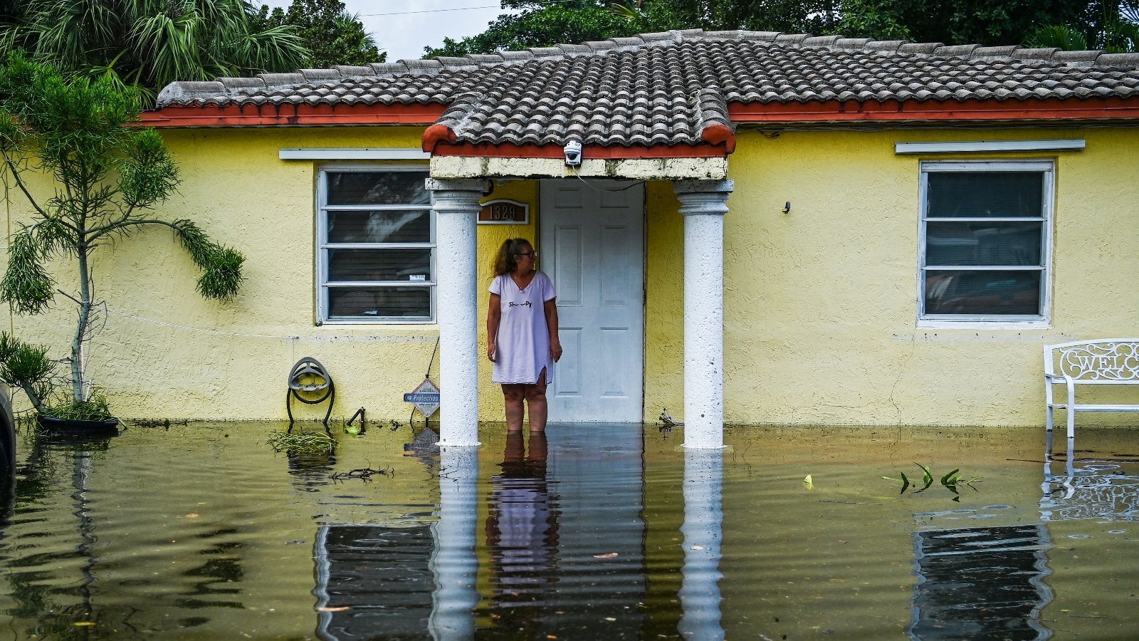
  • Domonique Tomlinson didn’t know much about the Shore Acres neighborhood of St. Petersburg, Florida, when she bought a house here four years ago, but she learned fast. Just a few weeks after she moved into her single-story teal home, a high tide overwhelmed her street’s drainage system and pushed water into her house. The same thing happened again during Hurricane Idalia in 2023; she lost furniture and belongings worth thousands of dollars. Then there was just the everyday flooding to contend with. It happened more times than she could count, when she had to wade through calf-high water on her street to get to her teaching job, wiping herself with Lysol when she got to work.

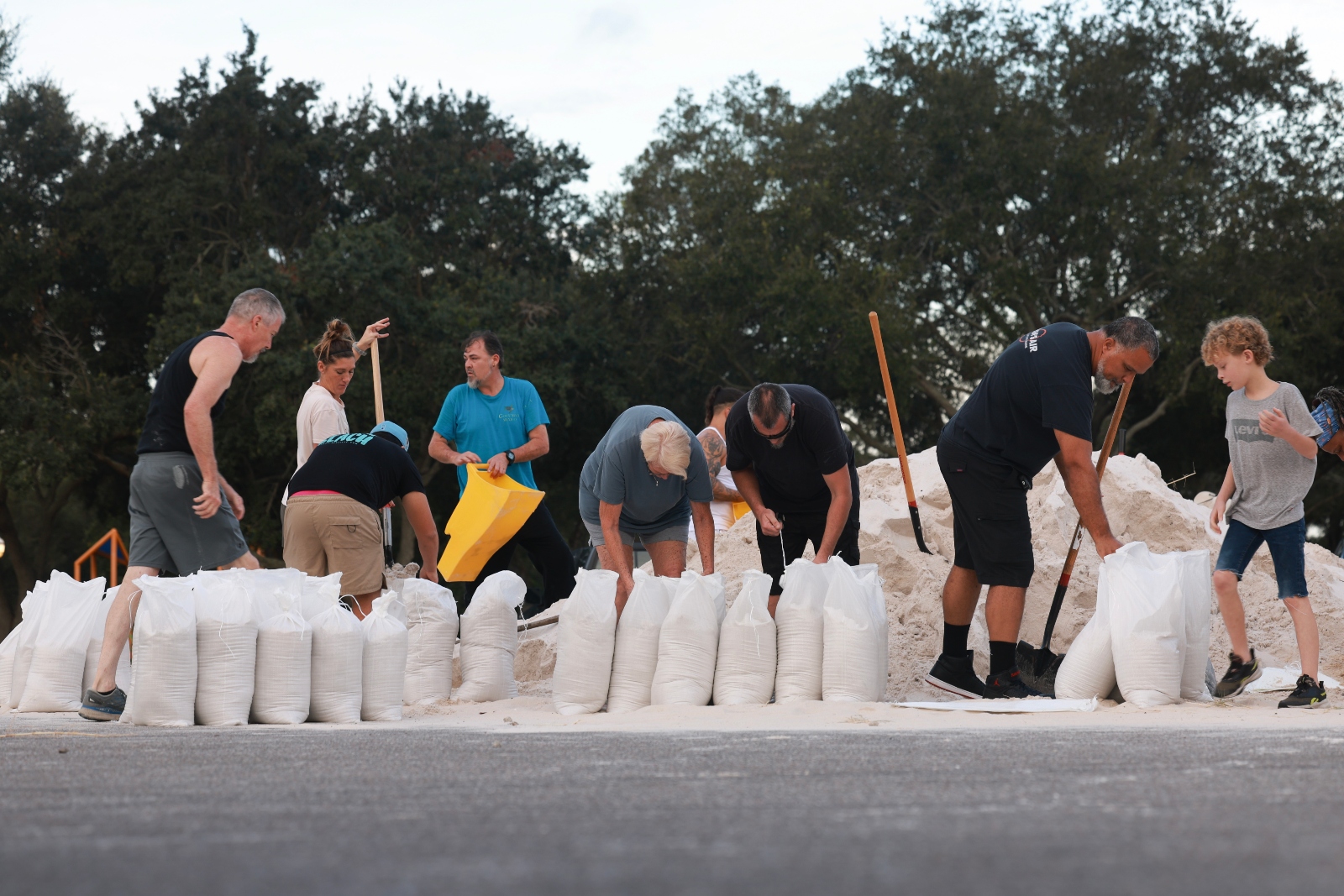
    Tomlinson and her husband were racing to install plywood flood panels and sandbags on Wednesday as Shore Acres prepared for a historic storm surge from Category 4 Hurricane Helene. As she loaded a Peloton into her car, she said she was fed up with flooding over and over again.

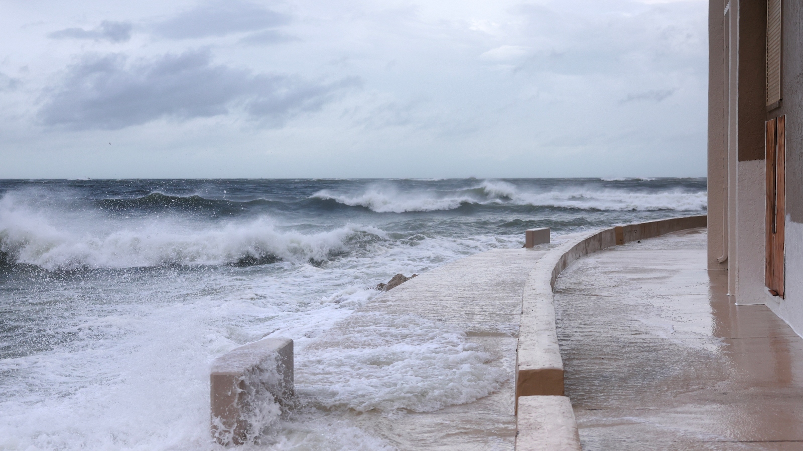
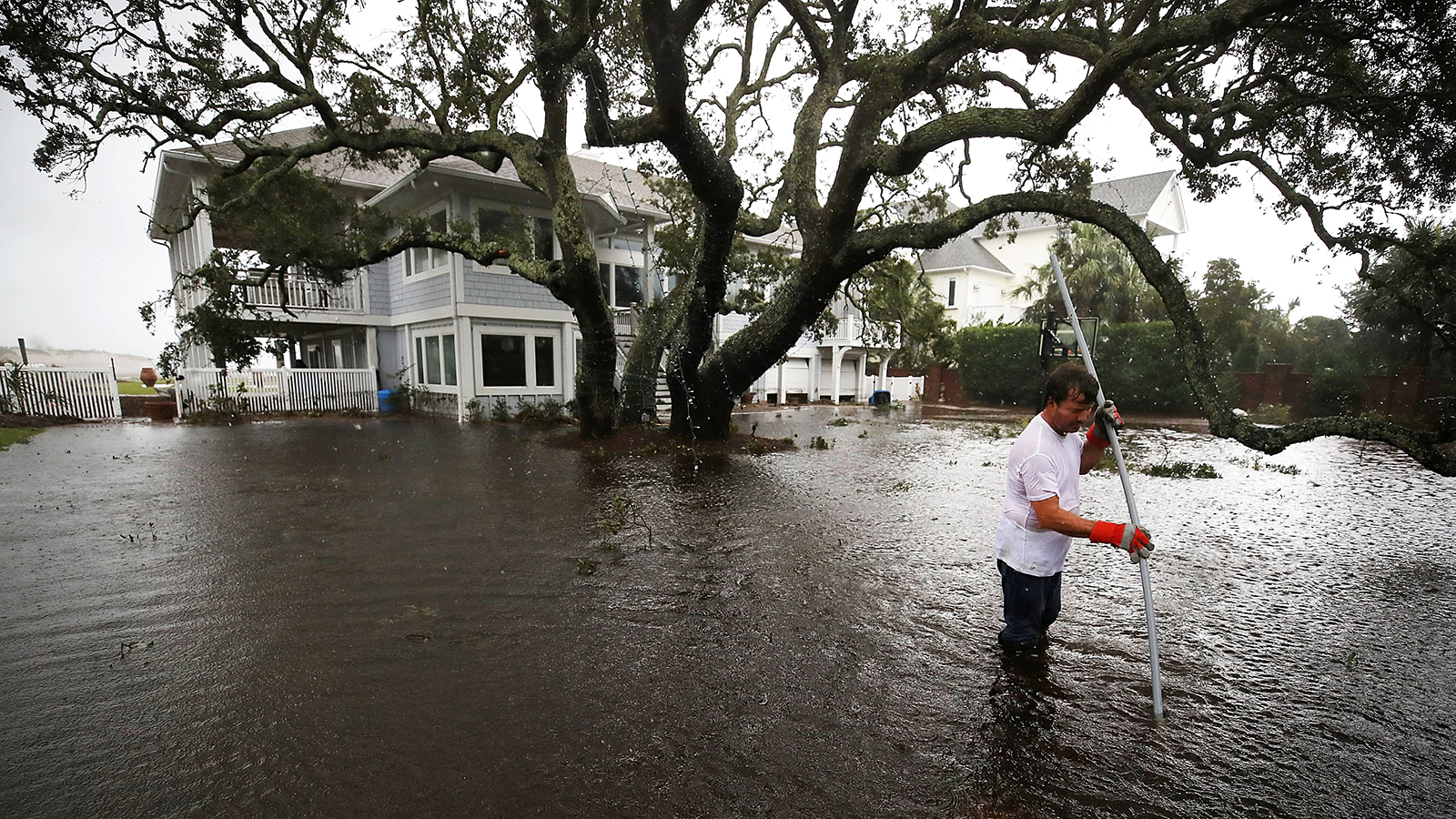
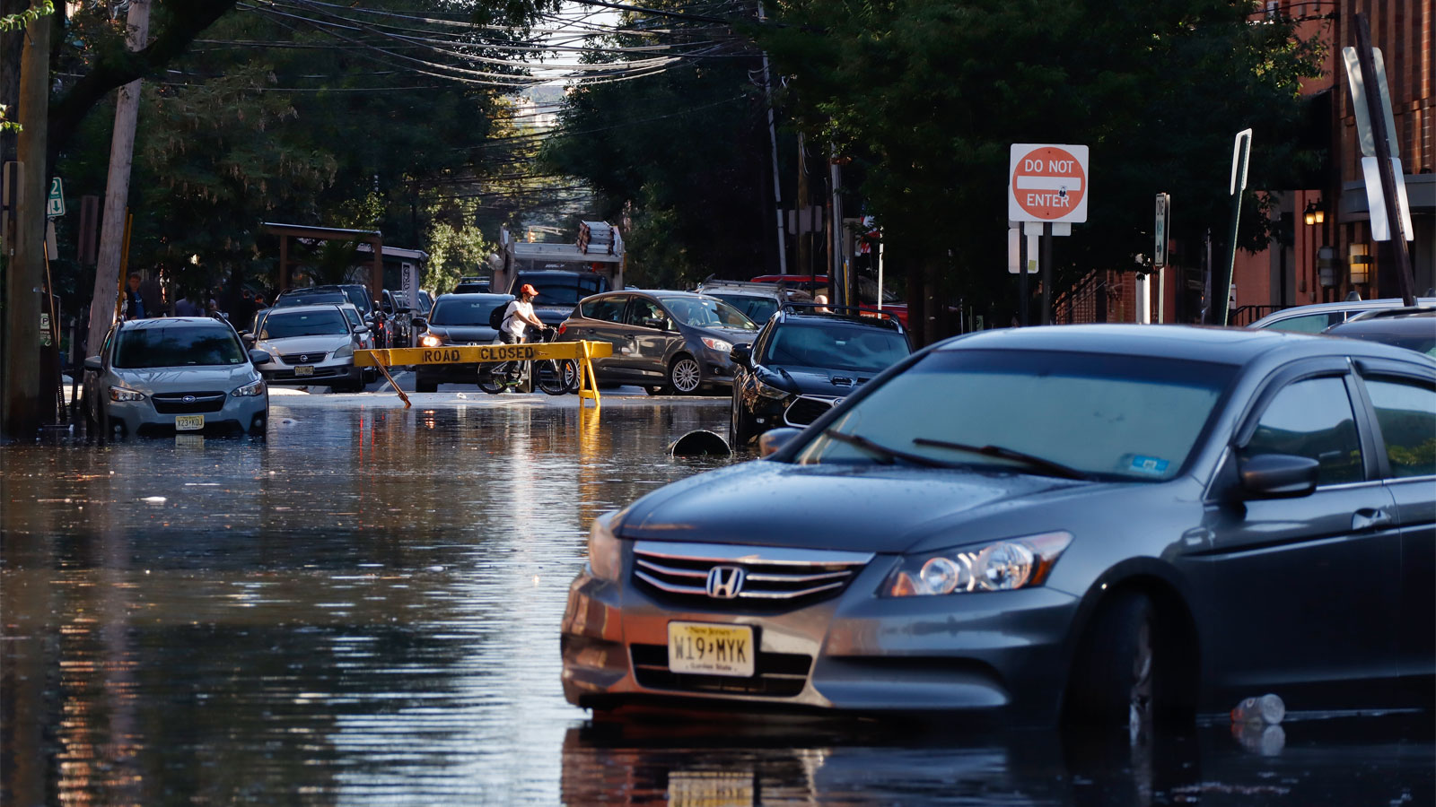
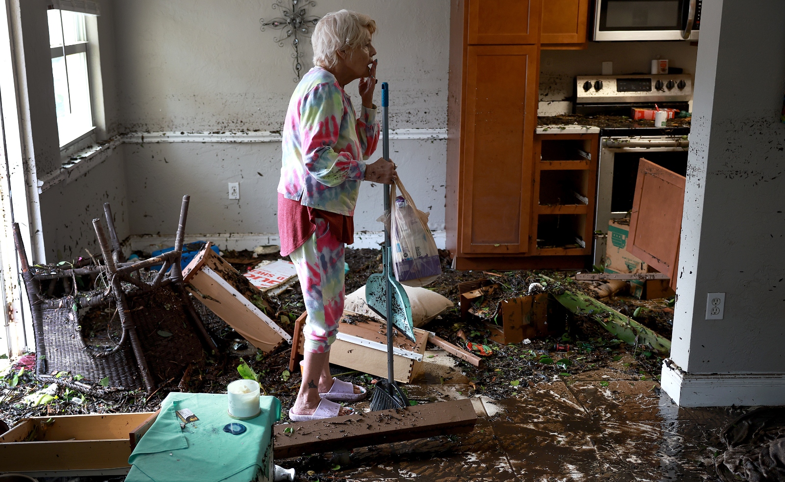
    The following night, Helene delivered the largest storm surge on record to Shore Acres, pushing water not only into Tomlinson’s house, but into the houses of neighbors who had never flooded. Waiting out the storm on higher ground in downtown St. Petersburg, she kept up with reports from her neighbors who had stayed behind: The entire streetscape vanished as saltwater seeped in through sandbags and flood panels, filling up kitchens and living rooms.

    “It’s just a really sad situation,” she told Grist. “We won’t rebuild, it’s not worth it.” 

    flood water line in shore acres florida hurricane helene
    A waterline marks where floodwaters from Hurricane Helene reached in the Shore Acres neighborhood of St. Petersburg, Florida, as seen on September 27. AP Photo/Mike Carlson

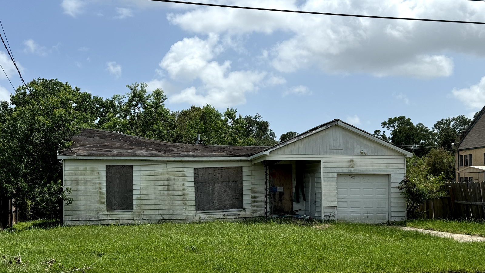
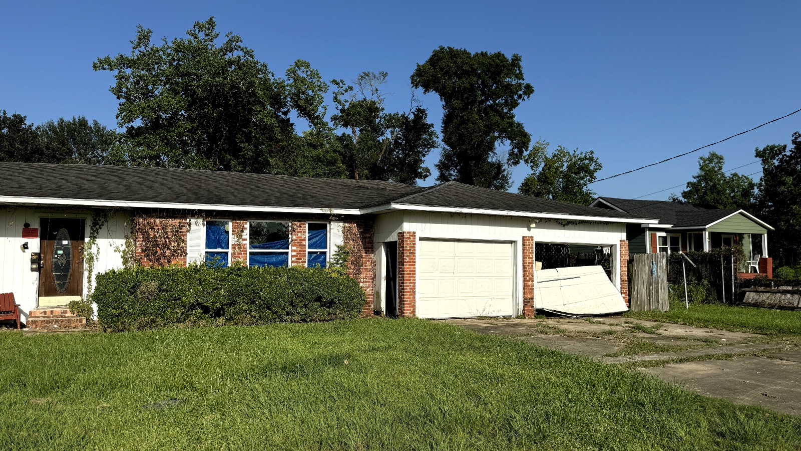
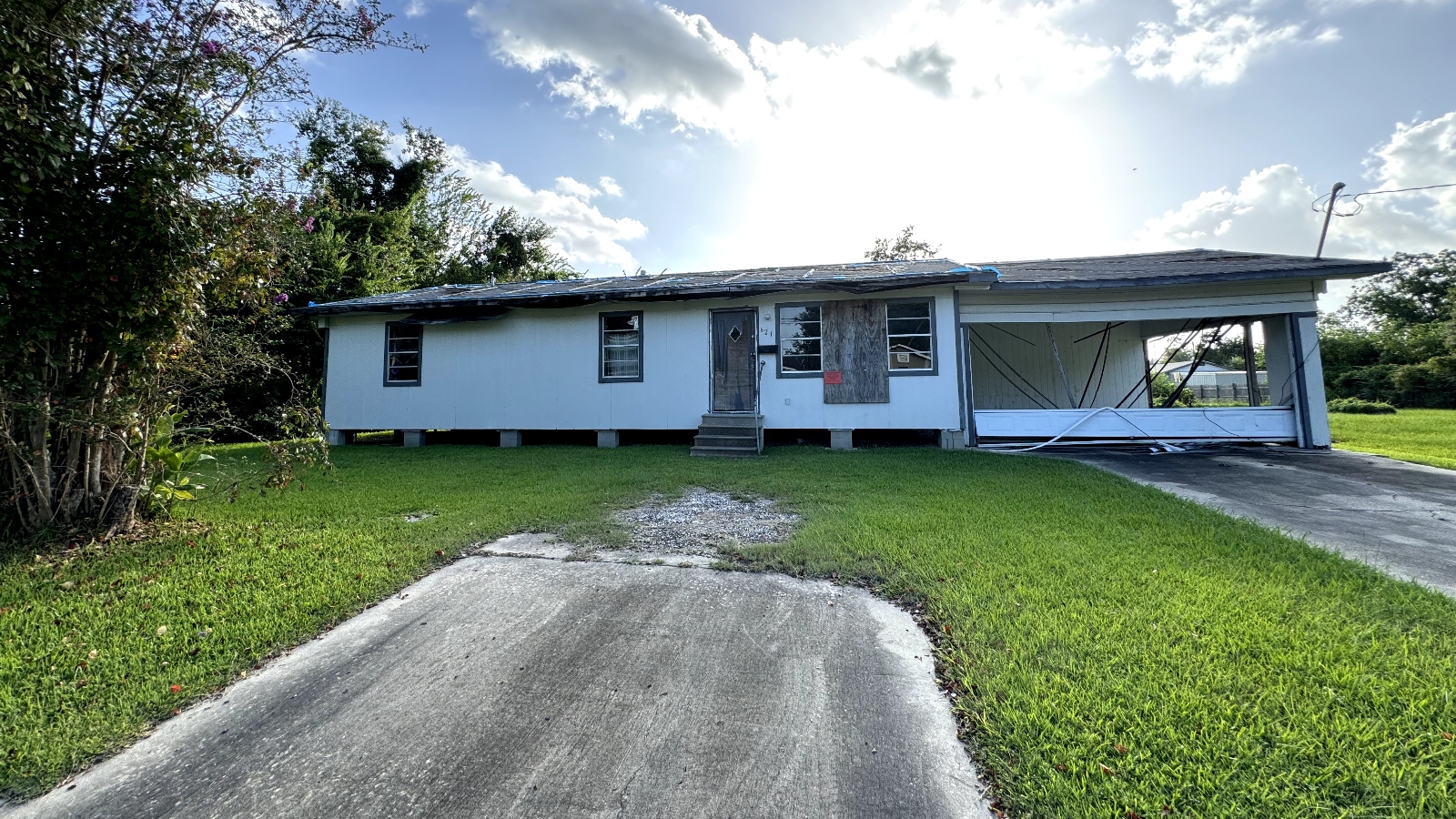
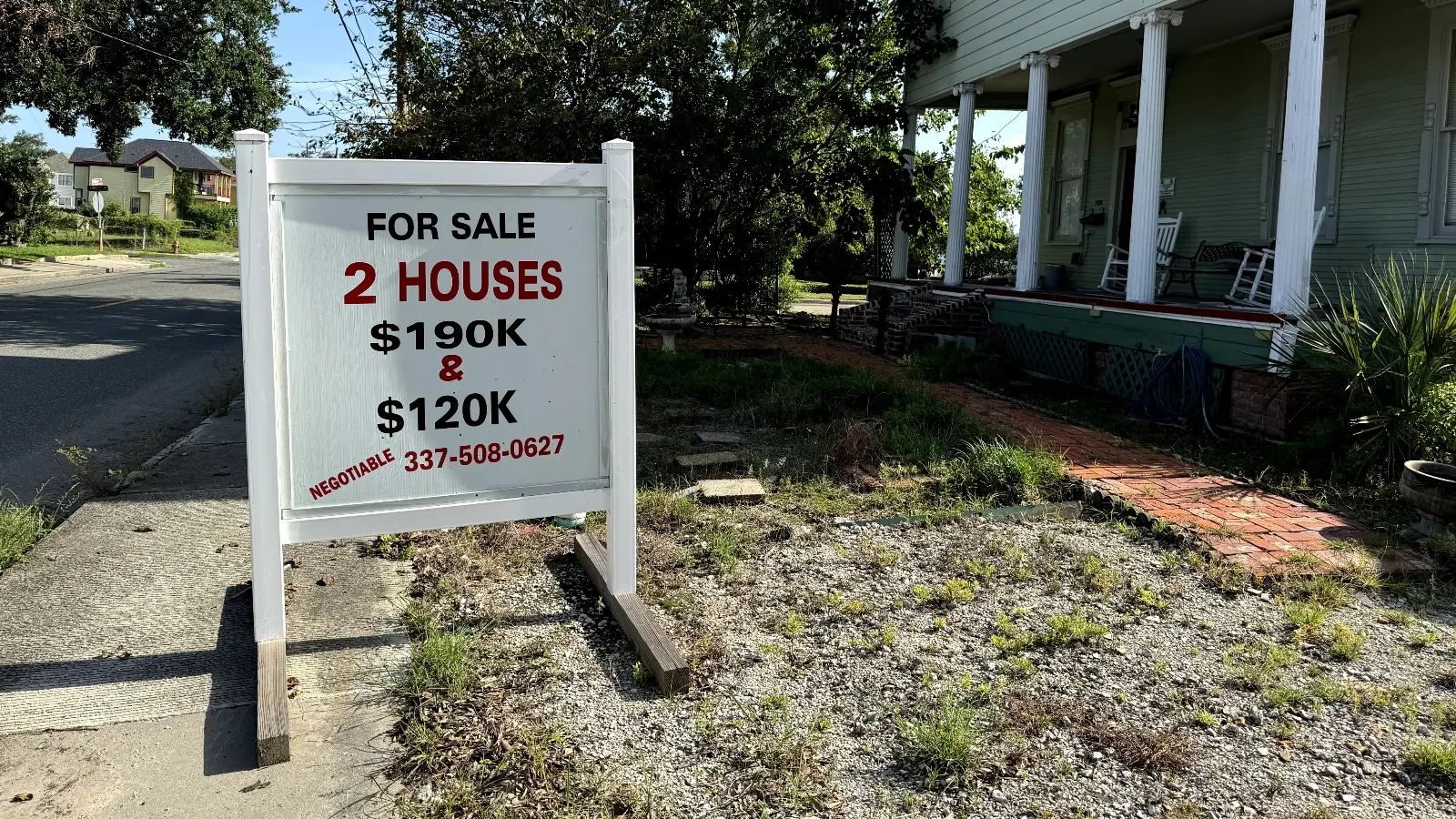
    Even before Helene, Shore Acres looked like a casualty of sea level rise and faulty development. The waterfront neighborhood had begun to flood multiple times a month, even when it wasn’t raining, and residents were paying some of the highest flood insurance rates in the country, with the median annual premium in the neighborhood set to reach around $5,000. The city was racing to mitigate the flooding, but almost every street in the neighborhood had at least one “For Sale” or “For Rent” sign on it. 

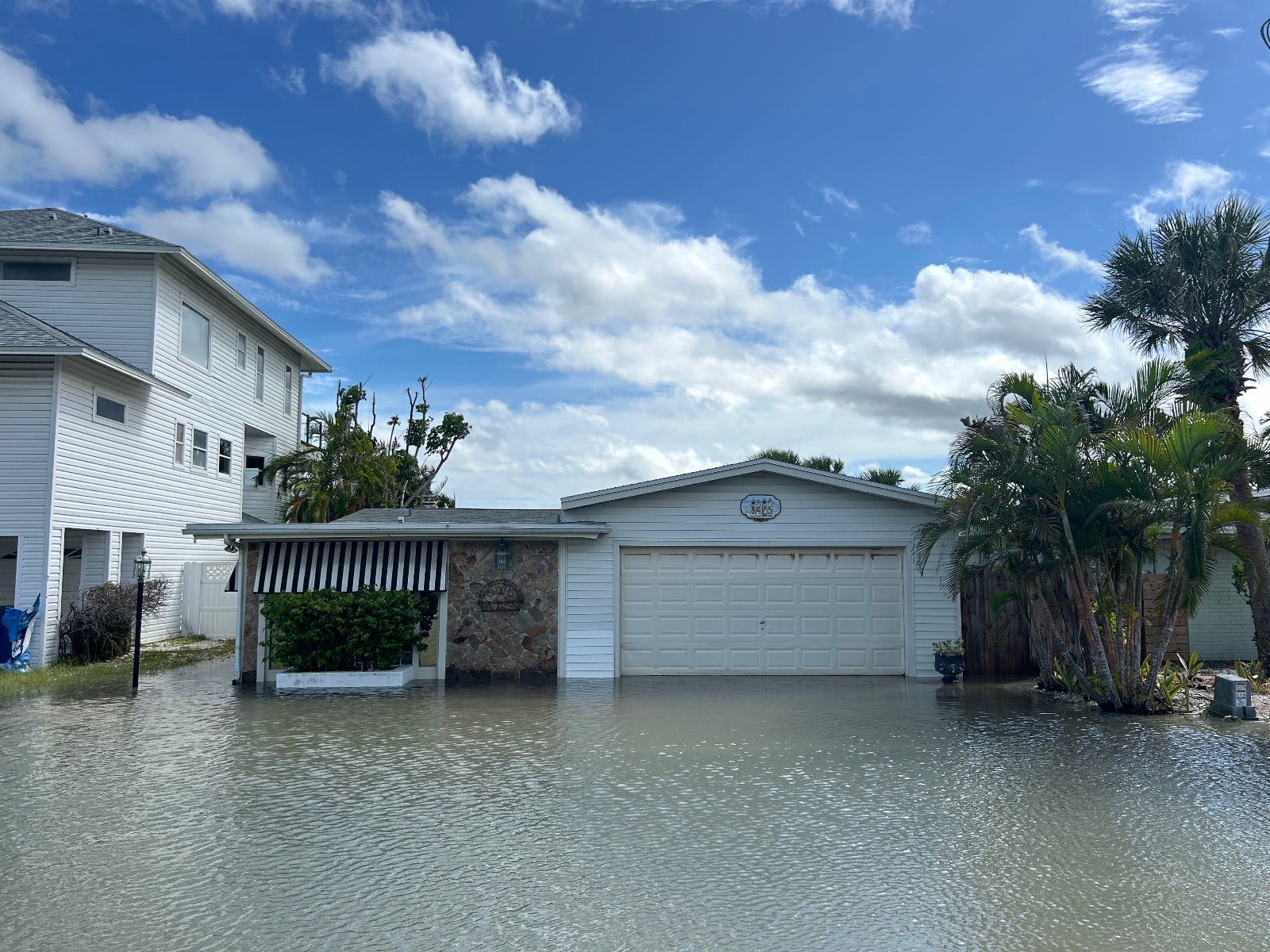
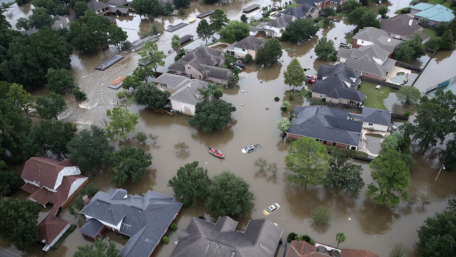
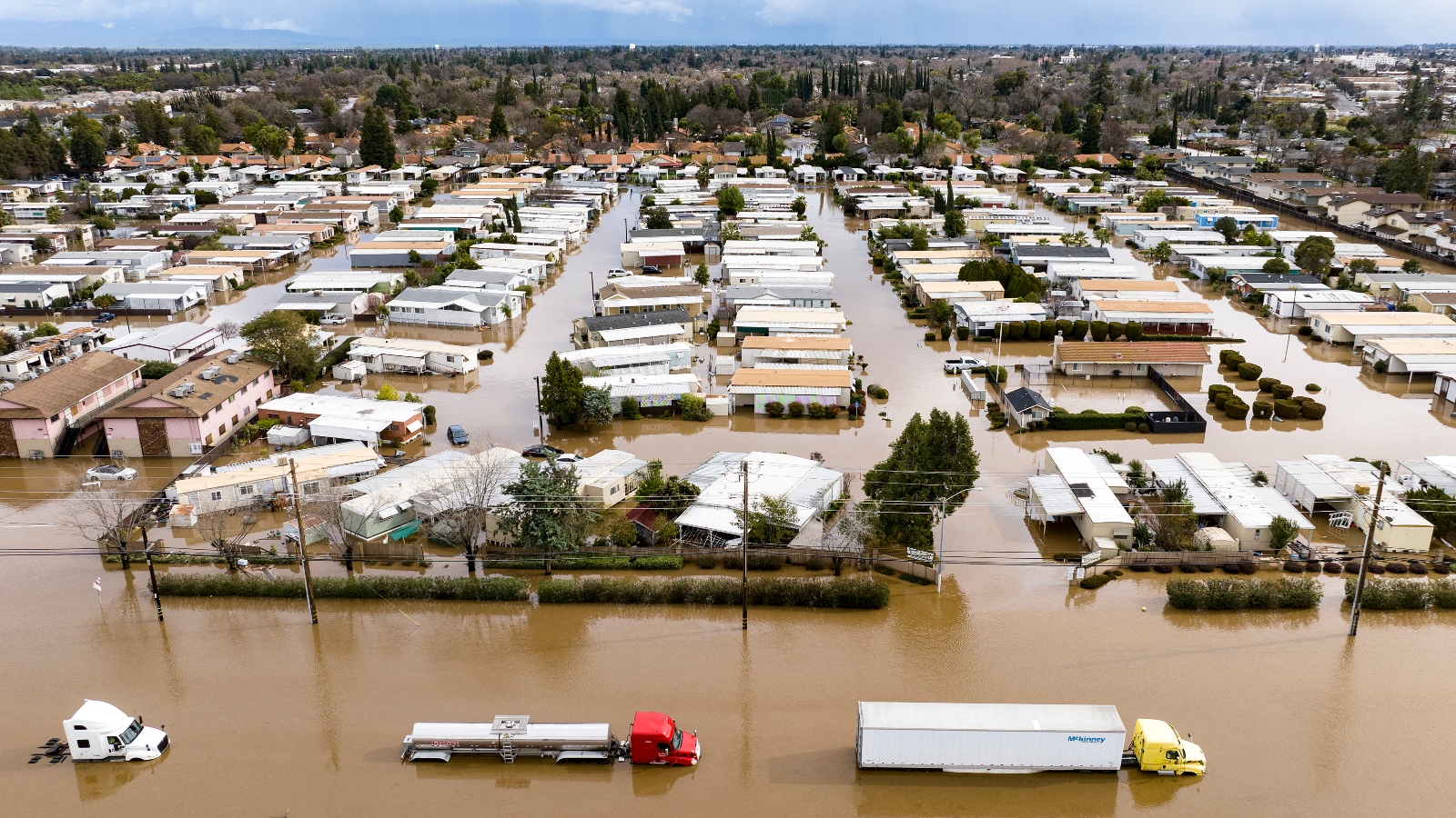
    But Helene may turn out to be the neighborhood’s coup de grace: The hurricane pushed well over 6 feet of storm surge into Shore Acres on Thursday, the highest on record for the community. Based on early reports, the wall of water flooded hundreds of homes with 4 feet of water or more, dealing another hit to its already shaky real estate market. And as sea levels and flood insurance rates continue to rise throughout the eastern United States, from Florida to New England, Shore Acres may turn out to be not an outlier but a bellwether for future fragility in the real estate market and coastal economies more broadly. 

    Shore Acres is one of numerous areas in the coastal United States that were built for a different climate than that of today: The area expanded in the 1950s on what one developer called “a pretty sorry piece of land” made up of pine forest and marsh, and much of it sits just a few feet above sea level. The area has always seen occasional flooding during the highest tides, but now parts of it go underwater several times a year as autumn tides slosh over bulwarks and gurgle up through storm drains. 

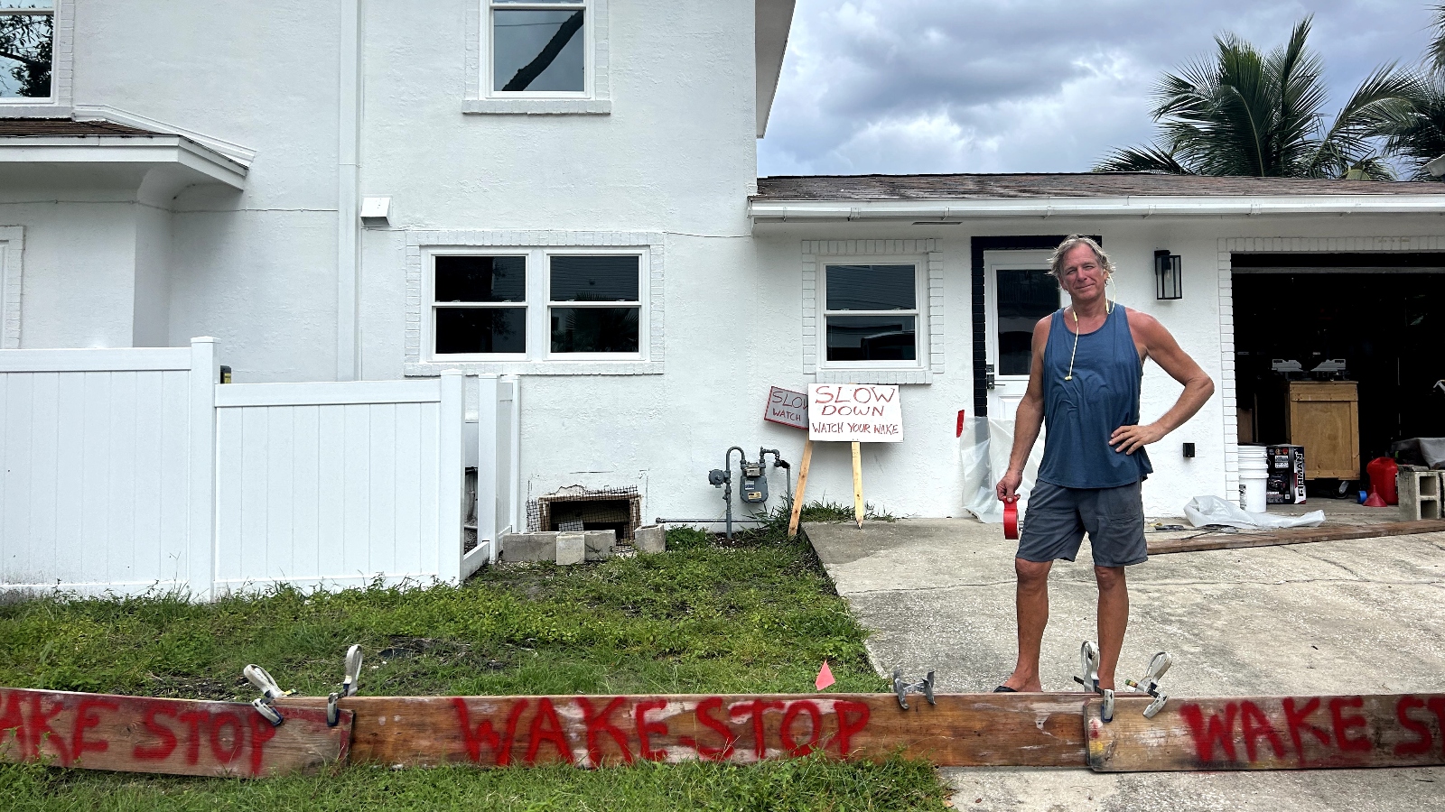
    Even on sunny days, standing water is now a frequent occurrence in the neighborhood. When cars drive too fast through flooded streets, they create wakes that can splash up into driveways and damage other vehicles, or even rush into homes.

    Tracy Stockwell, who moved to the neighborhood last year from Atlanta, has erected a series of signs and barriers in front of his house that read “Wake Stop” and “Slow Down, Watch Your Wake.” He said drivers have splashed through standing water multiple times and flooded his house — something he had no idea was possible when he bought it.

    “The realtors did not disclose that,” he said, while preparing to ride out the storm on his second floor. “We knew that the street flooded, but we had no idea the history of the house.” Earlier this year, Florida Governor Ron DeSantis, a Republican, signed a law that required home sellers to disclose past flood insurance claims, but the law doesn’t go into effect until next month.

    Homeowner stands near Wake Stop signs
    Shore Acres homeowner Tracy Stockwell stands in his yard next to “Wake Stop” signs, which aim to curb floodwaters from being pushed into his house by drivers. Jake Bittle/Grist

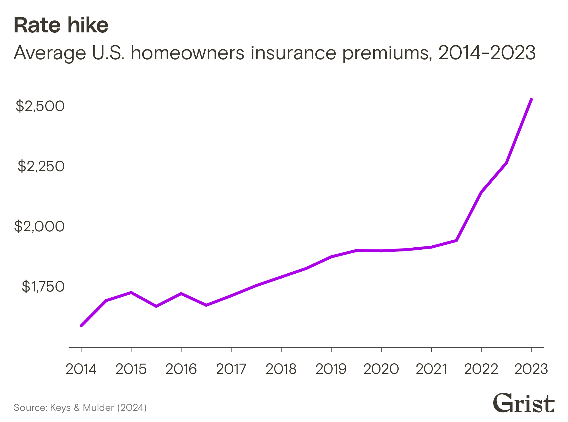
    As the flooding in the neighborhood gets worse, residents have seen their flood insurance rates skyrocket under a new federal policy. The Federal Emergency Management Agency, or FEMA, which administers the national flood insurance program that serves around 5 million U.S. households, began to roll out this policy in 2022. The median cost of flood insurance in the neighborhood is around $2,000 per year, more than double the national rate, and may double again to around $5,000 as FEMA raises rates to phase in the new program. Many residents already pay far more than that.

    Some neighbors have been able to save money on insurance costs by elevating their homes on stilts above flood level. Federal regulations require a homeowner to do this if their house suffers damage equivalent to more than half its value. But elevating a home requires a lengthy permitting process and can cost hundreds of thousands of dollars; moreover, FEMA’s new insurance pricing system offers a lower discount for doing this work than the old system did.

    For people who can’t afford to elevate or can’t keep up with rising insurance rates, the only option is to leave, and as of Wednesday there were at least two dozen “For Sale” signs in the neighborhood. 

    Even so, some local boosters are projecting confidence in the real estate market.

    “I think people understand now that flooding is going to occur,” said Kevin Batdorf, a real estate agent and the head of the Shore Acres Civic Association. “Flooding in Shore Acres is well known. It’s not something that is a secret. Some people have sold, and the houses are selling, because we live in a great neighborhood.” He went on to say that the neighborhood has seen small selloffs in the past after flood events, but that the market always calms down after a few months as new people move in. 

    But as Helene beared down, even those with deep connections to Shore Acres weren’t sure about their long-term future there. Tomlinson has said she won’t rebuild, and Stockwell said he planned to at least consider selling his home. They imagined their neighbors would be contemplating the same.

    “That guy left, and that person left, and that person’s selling,” said David Witt, a furniture store manager, as he pointed at the houses on his street. He and his wife moved a few years ago into his wife’s childhood home, which is raised a few feet off the ground, and they’ve come within an inch of flooding several times. They are both attached to the home, Witt said as he lined his door with sandbags, but they aren’t sure if they want to stay for good.

    A capsized boat near St. Petersburg, Florida, as Hurricane Helene churns offshore on September 26.
    A capsized boat near St. Petersburg, Florida, as Hurricane Helene churns offshore on September 26. Joe Raedle/Getty Images

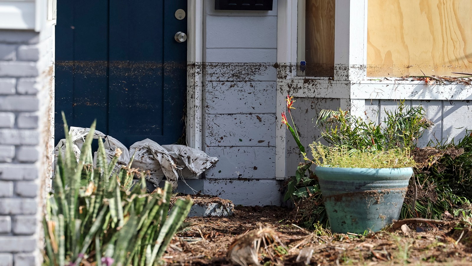
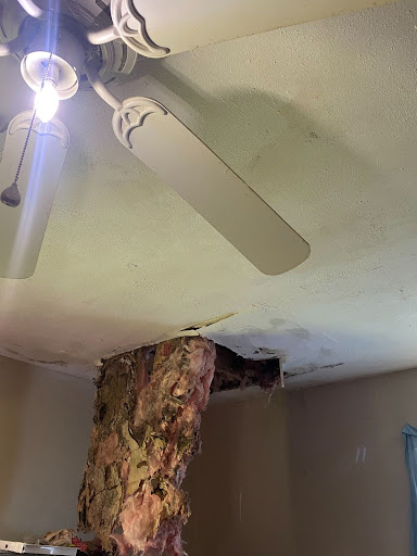
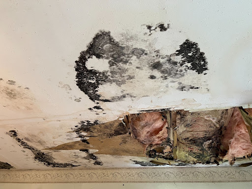
    There have been at least three other large floods in Shore Acres in the past 13 months, beginning with last year’s Hurricane Idalia and continuing this year with a no-name winter storm and Hurricane Debbie in August. The flood from Idalia damaged more than 1,200 homes in the neighborhood — close to half of all its structures. The neighborhood accounted for more than 80 percent of the damage St. Petersburg suffered during that storm. Helene traced a similar path to Idalia, scraping up the Gulf Coast and making landfall in the Florida Panhandle, but brought a storm surge several feet higher.

    The city of St. Petersburg has invested millions of dollars over the past year to mitigate its flooding issue, installing backflow preventers that stop storm drains from overflowing onto streets when tides are high. It will soon begin construction on a $16 million pump station on the area’s lowest-lying street, Connecticut Avenue, replicating a strategy used in Miami Beach and New Orleans with money from the state government.

    Batdorf, the civic association leader, said residents are working with the city to speed up these improvements and speed up grant programs that help residents elevate their homes.

    “There’s so much more the city could do,” he said, “and there are other communities that have solved the issue of flooding.” He said that despite the city’s progress on installing backflow preventers, the sunny-day flooding issue hasn’t gotten better. Furthermore, there’s nothing the city of St. Petersburg could have done on its own to stop a storm the size of Helene. To mitigate such a surge would likely require a multibillion-dollar barrier of the kind the Army Corps of Engineers has contemplated building in Miami and New York City. 

    “They’ve always had flooding here,” Witt said, “but it’s never been this bad.”

    This story was originally published by Grist with the headline This Florida neighborhood recovered from flood after flood. Will it survive Helene? on Sep 27, 2024.

    This post was originally published on Grist.

  • For the third time in 13 months, a hurricane is churning through the Gulf of Mexico on a collision course with Florida’s northwest coast, threatening a region still recovering from recent extreme weather with historic storm surge and dangerous winds stretching across hundreds of miles.

    But Hurricane Helene, which follows last year’s Hurricane Idalia and last month’s Hurricane Debby, is no ordinary storm, even by Florida’s standards. Like other high-profile climate-fueled storms of the last few years, it’s expected to undergo what meteorologists call “rapid intensification,” gaining strength at a phenomenal pace as it passes through the exceptionally warm waters of the Gulf. As a result, it’s poised to make landfall as a Category 3 or 4 storm just days after first forming in the Caribbean. It has also ballooned to become one of the widest storms on record, which will allow it to bring life-threatening winds and rain as far inland as Tennessee.

    Hope Webb, a real estate broker who lives in a beachfront area of the state’s sparsely populated Big Bend region, said on Thursday that she was hunkering down and hoping for the best as the storm was projected to make landfall that evening.

    “I am a lifelong resident of this area,” she told Grist. “I’ve weathered many a storm. I have faith God has his arms around us. But this storm is definitely testing our strength.”

    Three factors conspired to make Helene a particularly potent storm. Like any hurricane, its fuel is warm ocean water, which injects energy into the atmosphere as it evaporates. As Helene moved through the Caribbean Sea, it fed on exceptionally warm ocean temperatures made at least 300 times more likely by climate change, according to experts. As it continued its march north to the Gulf Coast, it gathered strength from water that’s both unusually warm and deep — a great big pool of high-octane fuel. 

    In addition, the region’s wind shear — a term referring to the tendency of winds to move in varied directions and speeds at different elevations — has been low. That atmospheric messiness would typically put a lower ceiling on a hurricane’s strength. Finally, high humidity has been another ingredient working in Helene’s favor.

    “It has had near perfect conditions,” said Karthik Balaguru, a climate scientist who studies hurricanes at the Pacific Northwest National Laboratory. 

    The combination of warm and deep ocean fuel, high humidity, and low wind shear have put Hurricane Helene on the cusp of rapid intensification, which technically refers to an increase in sustained wind speeds by at least 35 miles per hour within 24 hours. Scientists have found a dramatic increase in the number of rapid intensifications close to shore in recent decades.

    “The distinct signal of climate change is that it increases the proportion of intense hurricanes,” Balaguru said. “Storms tend to intensify faster, more quickly, and especially close to the coast.”

    That’s making hurricanes more dangerous than ever. For one, a coastal city might be preparing for an approaching Category 1 hurricane, only for it to suddenly morph into a Category 3. Well beyond the coast, the more powerful a hurricane is, the better it can resist dissipating as it moves over land and loses its source of fuel. And as the atmosphere warms, it can also hold more moisture, so hurricanes can dump more rainfall. 

    Residents fill sandbags at Helen Howarth Park in Pinellas Park, Florida, ahead of the arrival of Hurricane Helene.
    Residents fill sandbags at Helen Howarth Park in Pinellas Park, Florida, ahead of the arrival of Hurricane Helene.
    Photo by Joe Raedle / Getty Images

    For communities on the coastline, what makes a storm like Helene so dangerous isn’t just the winds and rainfall, but also the storm surge. A hurricane’s winds bulldoze water ashore — a perilous outcome for a region like the Gulf Coast, which is already experiencing sea-level rise. 

    The geography of Florida’s west coast makes things all the worse. While the ocean depths of some beach regions drop precipitously right off the coast, here the depths increase gradually as you move away from shore. If the water near shore were deeper, a storm surge could partly be absorbed by these depths, attenuating its impact on land. But with such shallow water off of Florida, the water has nowhere to go but straight into coastal communities. 

    Even though the eye of Helene is projected to make landfall Thursday night around Tallahassee, a hurricane’s strongest winds tend to blow in the northeast part of the storm. For Helene, those winds are poised to hit Florida’s less-developed Big Bend region, which also suffered the worst impacts from Idalia last year. That part of the state is extremely low-lying, so the storm surge could rush inland unimpeded by the kind of geographic features that would normally be mitigating factors. The projected surge could reach as high as 20 feet in towns like Steinhatchee, just south of where Hope Webb is riding out the storm at her beachfront home. In an announcement Wednesday night, the National Weather Service office in Tallahassee called these conditions “catastrophic” “potentially unsurvivable.”

    Farther south, the populous Tampa Bay region is also poised to see record surge figures after decades of near misses. “Just the shape of that coastline in that area, it definitely makes it unfortunately easier for that storm surge to pile up,” said Samantha Nebylitsa, who studies hurricanes at the University of Miami. “It sort of funnels into Tampa Bay, and so there’s really nowhere for the water to go but into that area.” In many cases, estimates suggest that Hurricane Helene is set to break surge records by more than 2 feet.

    As of early Thursday, the storm was still hours away from passing over St. Petersburg, but winds had already begun to pick up and the sky was darkening. Several gas stations in the city’s downtown ran out of fuel as residents filled up their tanks, and most people in low-lying areas had fortified their homes against flooding with sandbags, tarps, or door sealants. Flashing signs that read “HIGH WATER EXPECTED” warned drivers to stay away from the coastline. Counties all the way down the Gulf Coast, including those that include the cities of Tampa and St. Petersburg, had issued mandatory evacuations for residents in storm surge zones and those who live in mobile and manufactured homes. Streets in the beach city of Clearwater were already seeing local flooding.

    A flooded house in Treasure Island, Florida, ahead of Hurricane Helene. The hurricane brought tidal storm surge to St. Petersburg hours before making landfall in Florida.
    A flooded house in Treasure Island, Florida, the day Hurricane Helene was projected to make landfall. The hurricane brought tidal storm surge to St. Petersburg hours before landfall.
    Jake Bittle / Grist

    Hurricane Helene is a massive storm — its wind field is more than 400 miles across — so its rain will fall from the coastlines of Georgia and the Carolinas clear across to Missouri and Arkansas. As of early Thursday, every county in South Carolina, Georgia, and Tennessee was under some kind of flood or wind warning. Forecasters are warning of flash flooding, especially in the mountainous regions east of Knoxville and Chattanooga, Tennessee, as the storm stalls, and of dangerous wind that could cause widespread power outages through Georgia. 

    Like a car accelerating to a higher speed, Hurricane Helene can coast farther inland without running out of momentum, given just how much speed it has picked up as it has passed through the extra-hot Gulf waters.

    “It’ll essentially just slingshot itself into those states,” said Nebylitsa. “And with that speed, it’ll take a lot more for it to slow down.” 

    All these regions, whether coastal or inland, have substantial development that is uniquely vulnerable to flooding. The Florida coast contains thousands of homes on low-lying coastal land that is easy prey for storm surge, and states such as Georgia and North Carolina have built thousands of homes near rivers and streams that are likely to flood when Helene passes over. As intense hurricanes like Helene get more frequent, they’re exposing these vulnerabilities.

    “We’re entering this new normal of what we’re going to be experiencing under climate change,” said Michelle Meyer, director of the Hazard Reduction and Recovery Center at Texas A&M University. “But second to that, what’s been going on for a long time is that we continue to build in really risky places, in ways that are also pretty risky. So if we continue adding and adding more homes in areas that are going to flood regularly, or adding more homes on the coast without requiring greater mitigation, we’re going to continue seeing higher and higher dangers.”

    Ayurella Horn-Muller contributed reporting to this article.

    This story was originally published by Grist with the headline The ‘perfect’ conditions that could make Hurricane Helene ‘unsurvivable’ on Sep 26, 2024.

    This post was originally published on Grist.

  • This story is part of State of Emergency, a Grist series exploring how climate disasters are impacting voting and politics. It is published with support from the CO2 Foundation.

    During the presidential debate earlier this month, Vice President Kamala Harris was asked about her plan to fight climate change. Her response didn’t focus on the dangers of drought or rising sea levels, or unveil an ambitious plan to reign in fossil fuel emissions. Instead, her answer focused on home insurance. “It is very real,” Harris said. “You ask anyone who lives in a state who has experienced these extreme weather occurrences who now is either being denied home insurance or it’s being jacked up.”

    Just a few years ago, Harris’ insurance comments may have been considered wonky or boring to voters. But since 2020, the increasing number and severity of natural disasters like wildfires and hurricanes have cast home insurance markets into turmoil, leading to an explosive rise in premiums. 

    Unaffordable premiums now represent one of the most tangible ways that climate change is affecting everyday Americans. And this election season, insurance commissioners — the state officials in charge of overseeing these markets — are suddenly in the hot seat. 

    These officials have historically operated outside of the spotlight, steeped in financial statements and wonky regulations. In the 11 states that elect their commissioners — the rest appoint them — these races have rarely received much interest. In some elections, incumbents don’t even face a challenger. In others, state data shows that as many as 17 percent of voters simply skip over that section of their ballots. 

    “It’s just not something [voters] pay attention to until things go wrong,” said Dave Jones, who served as California’s insurance commissioner from 2011 to 2019. “Right now, things are going wrong.”

    In recent years, insurance companies have found themselves increasingly on the hook for homes hit by wildfires and severe storms. In Louisiana, a parade of back-to-back hurricanes and extreme storms in 2020 and 2021 caused insurers to pay out well over twice as much money as they brought in. Similarly, in Colorado, where the state has experienced over 40 billion-dollar disasters in the past decade, insurers lost money in eight of the past 11 years. 

    To pay for all this damage, premiums have been skyrocketing nationwide. According to a 2024 study of insurance rates, the average home premium rose 33 percent between 2020 and 2023. In disaster-prone areas like Florida, the Gulf Coast, and California, rates have increased even more, with some insurers pulling out of markets entirely. 

    Chart showing the average U.S. homeowners insurance premiums from 2014-2023


    “The insurance crisis that people and businesses are experiencing — not just in California, but across the United States — is the price that we’re paying for failure to more aggressively transition from a fossil fuel-based economy,” Jones said.

    These rising costs are prompting voters to take a closer look at elected commissioners that regulate the industry in their home states — and it is forcing candidates to more thoroughly consider insurance shifts and climate change in their platforms.

    States have been regulating their insurance markets for more than 150 years, with New Hampshire appointing the nation’s first commissioner in 1851. These regulators are tasked with setting reasonable limits on how much insurance companies can charge for home, car, health, and life insurance. They also oversee how insurers manage their money, so they have enough to pay their bills when disaster strikes. For the vast majority of their history, insurance commissioners haven’t thought much about climate change.

    “When I came in, climate change was kind of a footnote,” said Mike Kreidler, Washington’s outgoing insurance commissioner, who was first elected to the office in 2000. “That was something that bothered me a lot, because I saw the risks.”

    Kreidler’s early attempts at climate action were met with fierce resistance. As an early member of the National Association of Insurance Commissioners’ climate working group, he recalled some of his peers asking him to remove the word “climate change” from his proposals. “I took a lot of abuse back then on these issues,” Kreidler said. “It’s not something that a number of commissioners wanted to talk about.”

    Even in progressive states, climate change was often overshadowed by flashier issues. In California, Jones first ran for office in the wake of the newly passed Affordable Care Act. He and his 2010 opponent both campaigned almost entirely on health care issues. 

    But by Jones’ second term, it was clear things were changing. California was starting to see a worrying trend of expensive wildfires: Starting in 2015, California was hit with billion-dollar wildfires every year until 2023. One of the most tragic examples came in 2018, when the Camp Fire devastated the Northern California town of Paradise, leveling entire neighborhoods and displacing more than 50,000 residents. Jones spent his final year in office making sure fire victims received the claims they were owed, and writing recommendations to protect the system against future disasters. 

    Former California Insurance Commissioner Dave Jones holds up a copy of a report during a news conference about the costs of wildfires in 2018, in San Francisco.
    AP Photo/Eric Risberg

    Soon, other states joined California in starting to feel the effects of climate change on the insurance market. In 2021, home premiums — which had remained relatively stable until then — dramatically started to spike nationwide. Insurance commissioners could no longer afford to ignore the impacts of worsening extreme weather. Some candidates, like Delaware’s incumbent insurance commissioner Trinidad Navarro, have called climate change one of the most concerning issues going forward. It’s “become a number one issue for insurance regulators across the United States,” Jones said.

    It has become an important issue for voters as well. Over the last few years, major insurance companies have started backing out of high-risk parts of the country. California’s largest insurer, State Farm, stopped accepting new customers, and will not renew policies for roughly 30,000 homeowners and renters living in certain risky parts of the state. Meanwhile, in Florida, so many homeowners have been denied coverage that the government-created “last-resort” program is now the largest insurance provider in the state. This trend — of fewer and more expensive options — is leading some frustrated voters to turn their attention toward their elected leaders. 

    This year, North Carolina has become the battleground of one of the nation’s first insurance commissioner races centered largely around climate impacts. Coastal storms and hurricanes are taking a worsening toll on the state — like Hurricane Florence, which caused over $16 billion in property damage in 2018. In response, North Carolina insurers requested a 42 percent increase in home insurance rates. In certain coastal neighborhoods, they asked for a rate increase of 99 percent. 

    This proposal was met with fury: Insurance commissioner Mike Causey, a Republican, received more than 24,000 emails, and a public comment session held earlier this year was filled with roughly seven hours of angry testimony, from small town mayors to ordinary homeowners. Senior citizens feared that their social security income wouldn’t cover their new premiums, and local military families worried that their housing allowances would also fall short. Realtors worried the new rates would deal a devastating blow to the state’s housing market. Causey eventually rejected the initial proposal, calling them “excessive and unfairly discriminatory,” but has yet to settle on new insurance rates. Causey did not respond to multiple interview requests.

    For Natasha Marcus, a Democratic state senator challenging Causey in the election this year, this public outcry has brought a lot of attention to the commissioner race. According to an August poll from the group Carolina Forward, Marcus and Causey are currently neck-and-neck. “It’s the sexiest race on the ballot,” Marcus said, half jokingly. “As soon as people realize how directly it impacts their wallets, they take an interest.”

    Marcus is hoping for more transparency in the rate-setting process, to give customers a better sense of whether premium hikes are truly justified. Her vision is for a courtroom-like procedure, where insurers can make their case to the public, and her office can cross-examine their arguments.

    Democratic candidate for North Carolina’s Commissioner of Insurance, Natasha Marcus, speaks at a primary election night party in Raleigh on March 5.
    AP Photo/Karl B DeBlaker

    While Marcus acknowledges the threat of climate change, she feels that North Carolina insurers are using extreme weather as a pretext to ask for unreasonably high rates, pointing to a New York Times investigation that shows the state’s insurers have made profits 10 of the past 11 years. She worries that large insurance companies are seeking easy profits from North Carolina to make up for the money they’re losing in other states.

    A 2022 Federal Reserve analysis found that insurers are indeed quicker to ask for rate hikes in states with looser insurance regulations, and more hesitant in highly regulated states like California — even if those states experience frequent disasters. 

    However, Ben Keys, an economist and professor of real estate and finance at the University of Pennsylvania’s Wharton School, says that this trend does not explain the recent hike in insurance costs. He and a colleague recently analyzed premiums from 47 million homeowners across the country, revealing an unprecedented view into the causes of the insurance crisis.

    Over the past 40 years, Americans have been moving to more disaster-prone regions of the U.S. South and West. “A hurricane cutting the Gulf side of Florida now just encounters way more houses, way more businesses, way more roads, way more infrastructure than it did 40 years ago,” Keys said.

    At the same time, climate change has been increasing the frequency and severity of extreme storms and wildfires in those fast-growing regions. Finally, when disaster strikes, inflation and labor shortages have driven up the cost of rebuilding. 

    All of these factors have made disasters more expensive, and contributed to the rise in premiums. But the biggest factor behind the rise, according to Keys, is the way that climate change is reshaping a fundamental pillar of the insurance industry.

    Insurance is built around the assumption that disaster doesn’t strike everyone at the same time. For many types of insurance, that assumption is mostly true — a car insurer, for example, knows that it’s unlikely that every driver will get into a fender bender on the exact same day. But when it comes to home insurance, climate change is causing this assumption to crumble. A major wildfire could easily burn down an entire town, or a hurricane could easily rip the roofs off all the homes in a neighborhood. For this reason, insurance companies in disaster-prone regions end up purchasing their own insurance policies, known as “reinsurance.” 


    Reinsurance protects regular insurance companies from going bankrupt from a string of major disasters. Since reinsurance companies cover the epicenters of extreme weather, they’ve recently become extremely sensitive to climate risk. Since 2020, premiums for reinsurance have doubled, and will likely continue to rise. In states that experience frequent extreme weather disasters — like Louisiana, Texas, and Florida — insurance companies end up purchasing a lot of expensive reinsurance, and those costs get passed down to customers. 

    This is the biggest factor behind the recent surge in home insurance premiums, and Keys doesn’t expect it to stop anytime soon. In a recent interview with Bloomberg, Jacques de Vaucleroy, the chairman of the major reinsurance firm Swiss Re, said that reinsurance premiums will continue to rise until people stop building in dangerous areas. 

    This puts candidates like Marcus in a difficult position. Voters may hate high insurance rates, but they also love their state’s beautiful coastline. “It is not a solution to say, ‘Well, there will just be no houses on the coast anymore,’” Marcus said. “Nobody wants that.” 

    Mike Pollack searches for a drain in the yard of his flooded waterfront home in Wilmington, North Carolina, a day after Hurricane Florence in 2018.
    Mark Wilson/Getty Images

    Keys thinks that insurance commissioners will have to make some difficult and unpopular decisions going forward. He worries that elected commissioners might choose to please voters in the short term, instead of addressing the root causes.

    “It’s very fraught to have an elected official in charge of regulating this market,” Keys said. “If you set prices too low, then you make voters happy — but at the cost of not reflecting the true risk. That’s going to encourage people to build more in risky areas.”

    While Marcus believes the rate hikes proposed earlier this year in North Carolina were unjustified, she acknowledges that climate change will inevitably cause rates to increase in the future. “I never promise that I will never raise your rates if you elect me,” Marcus said. “It sounds really good on the campaign trail, but I tell the truth. And the truth is, sometimes rates do need to go up.”

    Instead, Marcus hopes that more transparency would keep insurers honest, and her campaign pledges to push for more adaptation and resilience. For example, North Carolina’s high-risk insurance program offers grants to policyholders to storm-proof their roofs. Marcus would like to see more resources devoted to that program. “If the hurricane comes through and your roof stays on, you’re going to have a lot less damage,” Marcus said. “That helps reduce insurance costs for everybody.” 

    This is something that insurance commissioner candidates in other states are pushing for as well. In Montana, a state that over the past decade has averaged 7.2 million acres burned annually, Republican candidate James Brown has called for insurance incentives for homeowners who implement fire resilience measures to their homes. In Washington, Democratic candidate Patty Kuderer has called for similar plans in her state.

    This combination of photos shows a house on a hillside near Cle Elum, Washington, surrounded by wildfire flames on August 14, 2012, top, and a day later, bottom. The house survived because of fire resilience measures, including the placement of the driveway and the lack of trees and brush up against the house.
    AP Photo/Elaine Thompson


    Jones, now the director of the Climate Risk Initiative at the University of California, Berkeley, has been advocating for similar reforms in California since leaving office. In recent years, the state and local governments have been spending millions on prescribed burning and thinning in order to make forests and communities more resilient to wildfires. Jones has been working with lawmakers to make sure California insurers take those investments into account when writing and pricing policies. 

    In this way, insurance could serve as both a carrot and a stick, discouraging people from building in risky areas, and also rewarding people for making their homes and communities more resilient. But Jones also hopes that voters will put the pieces together.

    “If the voters are connecting the dots, they should understand that what they’re experiencing — in terms of increased price and lack of availability of insurance — is driven by climate change, ” Jones said. “They should look to elect an insurance commissioner who’s going to be a leader in addressing the underlying driver of the problem, which is climate change.”

    This story was originally published by Grist with the headline Climate impacts put insurance commissioner races in the spotlight on Sep 24, 2024.

    This post was originally published on Grist.

  • Rural La Paz County, Arizona, positioned on the Colorado River across from California, is at the center of a growing fight over water in the American Southwest. At the heart of the battle is a question: Should water be treated as a human right, to be allocated by governments with the priority of sustaining life? Or is it a commodity to be bought, sold and invested in for the greatest profits?

    Source

    This post was originally published on Latest – Truthout.

  • Among those concerned about the climate, it’s become something of a self-evident truth that as people suffer more severe and more frequent extreme weather and grapple with global warming’s impact on their daily lives, they’ll come to understand the problem at a visceral level. As a result, they’ll be eager for action. In other words, many climate activists believe that even if advocates and academics can’t sway the hardened opinions of the dismissive, extreme weather can wake anyone up.

    The data disagrees.

    Over the last seven years, as the effects of climate change have begun to envelop the world in smoke and storm, natural disasters have in fact leapt front of mind for voters when they contemplate the most important reasons to take climate action. Those concerns, however, aren’t shared evenly across the political spectrum.

    Preventing extreme weather ranked among the top three reasons to address the crisis among 37 percent of voters surveyed this year, according to an analysis by the Yale Program on Climate Change Communication. That’s up from 28 percent seven years ago. For Anthony Leiserowitz, director of the Yale program, this shift reflects the fact that, while many Americans regard climate change with a certain psychological distance, the increasingly shared experience of smoke-filled skies, life-threatening heat, and earth-cracking droughts means “climate change is no longer distant in time and space,” Leiserowitz said. “It’s right here, right now.” 

    Mainstream media outlets are making that increasingly clear for their audiences, thanks in large part to the nascent field of attribution science that allows researchers to describe in real time the links between global warming and a given weather system.

    Grist

    The shift Leiserowitz and his colleagues detected was driven in large part by moderate and right-leaning Democrats. In 2017, less than one-third of those voters included preventing extreme weather among their top three reasons for desiring action, but by this year, half of moderate and conservative Democrats ranked it that highly. The opinions of moderate and left-leaning Republicans, however, stayed mostly unchanged, with just under 30 percent of those voters citing extreme weather as a top three reason to reduce global warming. Perhaps surprisingly, extreme weather even increased in relevance among conservative Republicans, with 21 percent listing it as a leading reason compared to just 16 percent in 2017.

    But even as extreme weather became increasingly salient among the most conservative voters, far more of them selected the survey option “global warming isn’t happening.” In 2024, a full 37 percent of conservative Republicans denied the reality of climate change, compared to 27 percent just seven years earlier.

    “People’s beliefs about climate change are driven predominantly by political factors,” said Peter Howe, an environmental social scientist at Utah State University who has worked with Leiserowitz in the past but was uninvolved in this analysis. The political and social circles a person occupies and the beliefs they hold not only mediate one’s overall opinions about climate change, Howe pointed out, but they influence how that person experiences extreme weather.

    When Howe collected and reviewed studies analyzing the connections between extreme weather and personal opinions about climate change, he found that although those already concerned about the crisis often had their anxieties heightened by a natural disaster, those who were dismissive before the event often remained so, ignoring any potential connection to global warming.

    When Constant Tra, an environmental economist at the University of Nevada Las Vegas, and his colleagues published a similar study in May, he found that disasters don’t shove people toward concern and alarm in the way he expected. At best, “it kind of nudges people,” he said, but rarely moves someone from an entrenched position of categorical denial, especially when those around them aren’t concerned.

    This dynamic reflects a groundbreaking experiment conducted in 1968 in which a college student was placed in a room with two actors. As smoke trickled into the room, if the actors pretended that all was fine, the test subjects rarely reacted with alarm or reported the smoke. In fact, they often assumed it wasn’t dangerous. In the climatic reprise of this “smoky room experiment” currently playing out in America, climate deniers are filling the role of the actors, trying to convince everyone around them that everything’s fine. Over time, those views spread and positions harden.

    But the smoky room experiment and Leiserowitz’s own research make something clear: Concern can be contagious, too.

    Screaming from the clock towers, however, is not enough on its own, Leiserowitz added. “It’s really important that people have an accurate understanding of the risks,” he said, without exaggeration or ignoring the fact that every little bit matters. That clear-eyed accounting of the risks must also be paired with an exploration of the solutions that exist, that we can implement with ease and efficiency, and that can make a meaningful impact today.

    This story was originally published by Grist with the headline Has extreme weather made voters care more about climate change? on Sep 20, 2024.


    This content originally appeared on Grist and was authored by Syris Valentine.

    This post was originally published on Radio Free.

  • Blowing 100 mile-per-hour winds, Hurricane Francine ripped into Southern Louisiana on September 11, knocking out power for hundreds of thousands of people. Its most dangerous and damaging effect, though, was the storm surge of seawater that it bulldozed ashore, inundating coastal parishes like Terrebonne and Lafourche. A preliminary estimate by AccuWeather puts the damage at $9 billion, which will likely be revised as scientists, insurance companies, and government officials gather more data. 

    In the days, weeks, and months after a hurricane like Francine makes landfall, a horde of public agencies and insurance companies try to figure out roughly how much they think the disaster will cost. That’s far more than just a number on the books: These estimates help state governments prioritize where to send aid and help kickstart insurance claims, allowing people and local economies to recover faster from disaster.

    You’ll often see dramatically different estimates of hurricane damage, because each is done with its own purpose: Preliminary assessments made by, for instance, the Federal Emergency Management Agency are used in the first 30 days after landfall to help determine if a major disaster declaration is warranted, and also helps officials figure out which public assistance programs might be needed in an area struck by a calamity. 

    Initial damage estimates can also raise public awareness, potentially boosting the amount of donated aid. “We saw this during Harvey in Texas back in 2017,” said Jon Porter, AccuWeather’s chief meteorologist. “Many people across the country did not realize the magnitude and severity of the damage and suffering during the storm. Once AccuWeather issued our preliminary estimate of the total damage and economic loss from Harvey at $190 billion, we saw a surge of additional help and relief flood into Texas from across the country.”

    Insurance companies can do a quick estimate of the damage, since they already have data on property values. “But really, to get an accurate picture, you need to do a careful case study,” said Adam Rose, who studies the economics of disasters at the University of Southern California. “These usually aren’t completed for another year or two, but it’s useful to have sort of a quick and dirty estimate right up front.”

    AccuWeather’s preliminary estimates collect a range of costs like property and infrastructure damage, lost jobs and wages, airport closures, and much else. “Our estimates also account for the cost of evacuations, temporary relocation and the long-term impacts on transportation, tourism and business logistics,” Porter said. 

    Tallying up how much a disaster costs also matters in the long-run because it signals to people the economic importance of disasters, and serves as an indicator on whether progress is being made on recovering from such events. On a national scale, one of the most frequently cited sources is the Billion-Dollar Weather and Climate Disasters dataset, a monthly report by the National Oceanic and Atmospheric Administration’s National Centers for Environmental Information. It records U.S. disasters that overtake the billion-dollar benchmark, gleaned from mining a mix of public federal and state statistics, as well as private sector data such as insurance claims, according to Adam Smith, an applied climatologist at the agency who leads the dataset. 

    Those billion-dollar price tags include losses racked up by a number of extreme weather events, such as hurricanes, severe storm events, tornados, floods, winter storms, wildfires, droughts and heat waves. Not all monetary damages are included in that count, though — just what NOAA deems “direct total losses.” 

    Their definition of direct total losses spans 16 different categories, including damage to homes, vehicles, businesses, government buildings — as well as what’s in them — business interruptions and the loss of living quarters when you’re out of your home as it’s repaired or rebuilt. The assessment also incorporates damage to roads, bridges, levy systems, electric grids, as well as crops. It is, as Smith describes it “a comprehensive yet still conservative estimate of what is truly lost.”

    There’s still a lot it doesn’t cover, like health-related costs that stem from a  disaster, or the environmental degradation that can happen when a hurricane hits, Smith said.

    Not only does the billion-dollar dataset estimate omit physical healthcare costs, but it also fails to count mental health crises left in the wake of natural disasters. And then there’s nature. Say a cluster of coral reefs or mangroves, two well-established natural buffers against storm surges, are damaged during a hurricane, effectively reducing the area’s resilience against future storms. Those associated costs also aren’t considered in the billion-dollar disaster damage assessment. 

    By not accounting for all these consequences, in addition to other expenses that tend to emerge post-disaster like supply chain interruptions, the dataset captures just a portion of a major disaster’s total price tag, and therefore only provides a snapshot of what losses look like as a warming planet makes disasters more frequent and severe

    And when something like the damage to mental and physical health isn’t accounted for, this can contribute to the exclusion of the very people who tend to lose the most in a disaster and what can be done to alleviate that historic burden

    “If all we focus on is the cost to the economy, disaster losses are bearable, right? Within our economy, the GDP tends to go up after disasters in the United States,” said Andrew Rumbach, a senior fellow at the Urban Institute. “That doesn’t mean they’re a good thing.” 

    After a storm hits, the loss of power and water, and the destruction of bridges and roads can make it difficult or impossible for businesses to start up again. These are their own forms of widespread economic losses. If a hurricane strikes New Orleans and Louisiana’s economic productivity dips in the following years, it takes a lot of number-crunching to determine how much the storm itself contributed, and how much productivity would have declined anyway. 

    The very nature of hurricanes means the economic damage can spread far beyond the coastlines they directly hit. Atlantic hurricanes form out at sea, using warm waters as fuel then might slam into ports along the Gulf and East coasts, like when Katrina caused $1.7 billion in damage to Louisiana’s ports. Even ports that don’t get hit can still cause economic ripple effects by  shutting down as a precaution as a storm approaches. Goods don’t get where they need to be on time, and the costs stack up.

    So in the longer term, the economic tallies of hurricane losses will often be much higher than initial estimates. But those first rough calculations are critical to avoid even bigger losses later. “Having insurance companies pay their premiums sooner,” Rose said, “having government assistance implemented sooner and more effectively, you can sort of kickstart the recovery and reduce those business interruption losses.”

    When talking about disaster damages, it’s mainly in the language of business and economics, punctuated with staggering dollar-signs. But there’s a risk that accompanies focusing too much on price tags, warns Rumbach, and that risk has to do with how disasters expose and exacerbate existing social divides. “There’s also just that bigger question that we should always ask: Is monetary value the right metric?” 

    The way Rumbach sees it, a hurricane can destroy a mansion and a dozen less expensive mobile homes. Although the damages to the mansion and the collective damages to the mobile homes as they are crunched by governments and insurance agencies might end up comparable, the scale of the impact just isn’t the same. 

    “Focusing too much on economic numbers, that really runs the risk of underestimating the impacts that disasters have for marginalized populations,” Rumbach said. “Everything involved costs less. They make less income. Their homes are worth less, their infrastructure is less of a cost. Does that mean that the disasters are less important because they cost less money?” 

    This story was originally published by Grist with the headline Hurricanes cost more than you think. Here’s why that matters. on Sep 19, 2024.

    This post was originally published on Grist.

  • Over the past century, the United States has built millions of homes along coastlines and rivers, developing on land that is all but destined to flood. At the same time that the warming of the planet has raised sea levels and increased rainfall, annual flood damages have surged in recent decades in large part because more homes are in flood-prone areas now than ever before. In coastal cities like Carolina Beach, North Carolina, most homes sit in a federally-designated flood zone, which tees them up for massive flood events like that which dropped more than a foot of rain on the city this week.

    Experts have portrayed this widespread risky construction as an intractable problem, alleging that “home sales in flood zones are booming,” that “more Americans are moving into flood…hot spots,” or pointing out “rapid urban growth in flood zones.” News coverage, including that of this publication, has largely followed this lead.

    But new research from some of the country’s leading climate adaptation experts, which was published last week in the academic journal Earth’s Future, suggests that academics and journalists may have drawn the wrong lessons from the last few decades of coastal development. A national survey of floodplain development between 2001 and 2019 has found that the U.S. actually built fewer structures in floodplains than might be expected if cities were building at random. This means that, if anything, the average city now actively avoids floodplains, contrary to conventional wisdom. Indeed, in the 21st century most towns and cities in the U.S. built very little or not at all in flood-prone areas. The vast majority of floodplain construction — the kind that grabs headlines and feeds the pessimistic narrative — has taken place in just two states: Louisiana and Florida.

    A separate paper just published by the same researchers in the journal Oxford Open Climate Change found that it doesn’t take a sea change for a town or city to effectively limit floodplain development. According to the paper, which is focused on New Jersey, more than three-quarters of Garden State towns reduced floodplain development after the turn of the last century, and around a quarter eliminated it altogether. They did this not by passing any big legislative reforms or climate policies but instead through what the paper calls “routine municipal practices” — things like zoning changes and permit denials.

    The researchers argue that the findings should reframe the conversation around floodplain development. While risky construction remains a significant driver of flood damages and disaster recovery costs, it is not the intractable problem that experts and journalists often make it out to be. 

    “We are building a lot in floodplains, but it’s not as bad as you think,” said Miyuki Hino, a professor of urban planning at the University of North Carolina, Chapel Hill, and an author on both papers. “Avoiding development in floodplains is doable, and we can do even more of it.”

    There are any number of reasons why a developer might want to build near the water. For one thing, many people like living near oceans and lakes, so homes and apartments built near those bodies of water can fetch higher sale prices and rents. Coastal states like Florida also depend on beach tourism to sustain their economies, so it makes sense to cluster housing and shopping near the ocean. Plus, many towns and cities in the United States were built along rivers for navigational purposes, so a disproportionately large share of urban land is likely to be in or near the floodplain.

    All those factors might lead one to expect that an outsize share of recent U.S. housing development would be in floodplains. But at least since the turn of the century, the opposite has been the case, according to the new study: Developers have built 844,000 units of housing on 2.1 million acres of floodplain — but if they had chosen available parcels at random, they would have built even more than that. This was true for more than 75 percent of all jurisdictions studied, indicating that most governments make at least some substantive attempt to avoid coastlines and riverbanks.

    It also indicates that the overall increase in flood risk is being driven by a few outliers, many of them clustered in Florida and Louisiana. A large share of available land in these states is located in either coastal or riverine floodplains, and both states’ economies largely depend on proximity to the water. A separate report published this week by the Natural Resources Defense Council confirms this contention from the study: Of the more than 250,000 properties in the U.S. that have filed multiple flood insurance claims, around half of them are in states along the Gulf of Mexico.

    “When we tell the story that the United States is building a ton in the floodplain, we miss out on the fact that that’s not true everywhere,” said A.R. Siders, a professor of public policy at the University of Delaware and an author on both papers. “Some places are actually not building in the floodplain. And then there are some places that are doing so terribly that they make the whole whole country look bad.”

    There are two ways of looking at the problem: A county on the Florida coast might build far more homes in the floodplain than a county in the Nevada desert, but the Nevada county may be building a larger share of new homes in the floodplain than the county in Florida. The storm damages, insurance claims, and rebuilding costs in the Florida county will be far higher, but the Nevada county has a lot of work to do as well, because it is placing new homeowners in harm’s way when there is ample other land available.

    Politicians, academics, and climate activists have proposed a wide variety of sweeping policy changes that could help cut down on floodplain development. Some have suggested that federal housing finance agencies should no longer securitize mortgages in flood zones, or that the federally-run National Flood Insurance Program should stop insuring them, or that states should ban such development outright. Given that efforts to simply raise flood insurance rates to market levels have generated huge blowback, these strategies would likely create massive political controversy.

    But when the researchers zoomed in on New Jersey, which developed most of its coastline in the twentieth century, they found that the solution may be simpler than that. In a survey of 500 towns, they found that more than 120 had eliminated floodplain development without any big policy change. The zoning commission just denied permits to developers, or the mayor told them to build on higher ground, and that was that.

    “There are a lot of new and innovative ideas for how to deal with this, but they’re maybe not necessary for the majority [of risky development cases],” said Siders.

    “It shows that when you regulate what’s going on in high-risk areas, you do see a perceptible impact on exposure and risk,” added Oliver Wing, the chief scientific officer at Fathom Global, a flood insurance mapping company owned by the reinsurer Swiss Re. “There are some very simple solutions that you can enact locally.”

    What about the small share of jurisdictions that account for most floodplain development? The authors argue that these places need targeted intervention. The state or federal government could provide subsidies to encourage less risky construction, helping offset the economic lure of waterfront construction, or a state could just impose penalties on cities that allow for new builds near the water. According to Siders and Hino, the precise solution in any situation needs to be tailored to the reasons a given locality is developing in the floodplain in the first place Some towns may develop in the floodplain because they lack the capacity to plan for a shift to higher ground, as is the case in many rural areas, and others may do it to capture tax revenue from the wealthy owners of vacation homes. While designing such policy solutions might be tricky, the authors argue that the local nature of the solutions should be cause for optimism.

    But Wing, who has led previous research that projected a nationwide increase in floodplain development, cautioned that there are limits to the progress that the new papers document. The researchers show that many governments are regulating floodplain development, but most of these regulations only apply to flood zones as delineated by the Federal Emergency Management Agency, which produces flood insurance maps for most of the country. However, these flood maps are old and often inaccurate, and a huge share of flood damage occurs outside of floodplain boundaries. This was the case during 2017’s Hurricane Harvey, when three-quarters of damaged homes in the Houston area were outside the lands that FEMA deems flood-prone.

    In other words, while towns and cities may be acting to reduce flood exposure, they will likely have to go even further to eliminate flood risk altogether. This would entail even costlier trade-offs between the economic benefits of development and the economic risks of construction in climate-vulnerable areas.

    “We have some excellent evidence here that when you have a flood map, it’s successful in restricting development,” Wing said. “Regulations have worked. But what about all the places that aren’t subject to those regulations?”

    Editor’s note: The Natural Resources Defense Council is an advertiser with Grist. Advertisers have no role in Grist’s editorial decisions.

    This story was originally published by Grist with the headline The US is finally curbing floodplain development, new research shows on Sep 19, 2024.

    This post was originally published on Grist.

  • Since she began studying mechanical engineering as an undergraduate at Stanford University, Ufuoma Ovienmhada had little desire to build “tech for tech’s sake.” The university’s sustainability lab offered one route to the applied side of engineering that appealed to her. One summer, she worked with the lab’s researchers on a project in Ivory Coast, in West Africa, where she considered how engineering could be employed for sustainable development.

    Undergirding Ovienmhada’s academic work was a burgeoning political consciousness shaped by the police murders of unarmed Black people. In her recollection, her college tenure, between 2014 and 2018, was “the Black Lives Matter era of police violence being broadcast on social media every other week.” She regularly attended protests and participated in Black campus organizations where she and her peers frequently discussed police brutality. While researching policing protocols at Stanford, Ovienmhada remembers being told by a campus officer that someone walking down the street in a hoodie would automatically be considered suspicious. “You’re telling me that racism is embedded in how you operate,” she remembers thinking.

    Ovienmhada went on to enroll in a master’s program at the MIT Media Lab, where she studied the use of satellite imagery analysis to manage invasive species in the Republic of Benin. She was in school during yet another period of time punctuated by police murders — this time of Breonna Taylor and George Floyd. The unprecedented nationwide protests against police brutality in the summer of 2020 encouraged Ovienmhada to pivot from international development work to the domestic issues of policing and mass incarceration. She wanted to figure out how she could apply her skills as an engineer and programmer to address the problems that concerned her most deeply. As young people across the country took the streets to demand an end to racist and violent policing, Ovienmhada learned about the nascent field of prison ecology, which focuses on the environmental hazards within and around carceral facilities (prisons, jails, and immigrant detention centers) and how they affect incarcerated people and surrounding communities. 

    At the time, academic writings in prison ecology were limited to a handful of journal articles in the social sciences. It seemed to her that few were considering how to apply quantitative methods to uncover the environmental issues affecting incarcerated populations. There was a gap in the data, and she felt called to help fill it. 

    A mock prison cell, intended to simulate the heat inside Texas prisons, sits outside the Texas State Capitol building in Austin, Texas in July, 2023. SERGIO FLORES/AFP via Getty Images

    Though the world of academia was only beginning to wake up to the study of prison ecology, organizers working against mass incarceration had already spent years drawing connections between environmental justice issues and the conditions in prisons. Members of the national grassroots organization Fight Toxic Prisons, or FTP, which uses advocacy and direct action to challenge the prison system, were well aware of not only the litany of environmental hazards that incarcerated people in the U.S. face, but also the value of quantitative research and, in particular, geospatial analysis in shaping the work of the decarceration movement. 

    “There is so much about this issue that is very geographical,” said Mei Azaad, an organizer with the Fight Toxic Prisons, adding that so many of the environmental hazards in prisons come from their proximity to oil and gas infrastructure or to Superfund sites. The lack of data to inform them where specific environmental hazards were concentrated was “something we kept running up against,” she said. By 2020, FTP had been doing disaster response work for a few years, and they knew how useful it would be to have a flood risk map overlaid on top of a map of U.S. carceral facilities, something they could refer to when determining how to prioritize their advocacy efforts. Meanwhile, in the course of her own research, Ovienmhada realized that she could apply her knowledge of remote sensing, which enables practitioners to map a range of environmental indicators such as flood risk, air quality, and heat exposure to wide geographic areas, to contribute better applications of geospatial analysis.

    From her apartment in Cambridge, Massachusetts, Ovienmhada had been keeping up with FTP’s work. On social media, they often posted data and mapping-oriented information about prisons. She was initially hesitant to reach out to the group and offer her help — aware of the hesitation that community organizers often have toward academics. But, coincidentally, a friend who worked on FTP’s disaster response team heard about Ovienmhada’s satellite imagery-based approach to studying prison ecology, and offered to make the connection. 

    Ovienmhada joined FTP’s rapid response team in 2022, the year the Category 4 Hurricane Ian barreled through central Florida, taking out power in wide areas of the state, killing 149 people, and causing over $100 billion in damage. As the storm approached the Florida coast, she made a map showing that several of the state’s carceral facilities were in mandatory evacuation zones, but were not being evacuated. After a phone banking campaign in which they informed Tampa’s Hillsborough County Jail of the map they’d made, the facility decided to evacuate its incarcerated residents.

    “We can’t say that they did this because of FTP but it was cool to see this kind of map used to mobilize,” Ovienmhada said.

    The Toxic Mapping Project allows users to explore a range of environmental hazards in prisons.

    Over the past several years, a growing body of academic work has established that prisons expose incarcerated people to a long list of severe environmental hazards. A 2022 report from the American Journal of Public Health found that nearly half of the country’s prisons rely on water from sources contaminated with “forever chemicals,” toxic compounds that do not break down easily in the body and have been linked to serious health effects like cancer and kidney disease. Earlier this year, a group of researchers examined heat exposure for all 4,078 operational carceral facilities in the continental U.S. between the years 1982-2020, and found that prison populations are highly vulnerable to extreme heat exposure, a problem that is only increasing with the climate crisis. Though these kinds of research projects offer valuable insights into environmental conditions afflicting prisoners, Ovienmhada said, they do not often respond to the needs of groups like FTP that want to use satellite data to take immediate action against specific prisons and, ultimately, to advance decarceration. 

    Ovienmhada found that she enjoyed using the skills she’d developed to aid FTP’s organizing work. But the technical abilities to design maps and build models weren’t the only hurdles that the practical applications of prison ecology had to overcome. The programs and server space to build the maps can cost thousands. They needed money, which is often more readily available to research a problem than to do something about it. 

    Ovienmhada’s connection with FTP coincided with the Biden Administration’s big push for environmental justice, a span of several years that saw the formation of White House advisory committees on the issue and the dispersal of millions of federal dollars to research projects illuminating the disproportionate impacts of environmental stressors on communities of color across the country. For the first time, federal agencies were under a federal directive to support environmental justice initiatives. In April 2023, President Biden passed Executive order 14096, which directs the federal government to strengthen its commitment to environmental justice by funding scientific research and data collection initiatives, in addition to engaging with local communities.

    Ovienmhada was just starting her PhD in aerospace engineering when she noticed that NASA had published a solicitation for proposals from academics to use the agency’s satellite imagery to study environmental injustices. The highest tier of funding — $250,000 — was to be awarded to projects that developed a geospatial tool for integrating satellite data and other socioeconomic information around an environmental justice issue. It was the opportunity Ovienmhada and FTP had been waiting for. They quickly put together an application, in which they proposed a different approach to data gathering. Rather than just visualizing environmental-hazard data on top of a map of U.S. carceral facilities, they wanted to incorporate the voices of people held in those same facilities. This qualitative approach, they reasoned, would fill in gaps in their knowledge, illuminating problems that couldn’t be picked up by an infrared camera hovering in space. Several months after they submitted the application, they were informed that they’d won. 

    They saw the tool they wanted to develop as an intervention into the proliferation of data-driven mapping tools that government agencies and academics have built over the past four years, which illuminate disparities in environmental harm across the country but do little to compel suitable solutions. The federal Council on Environmental Quality, for instance, released the Climate & Economic Justice Screening Tool, an interface that explores the concentration of climate risk in low income communities. The Environmental Protection Agency also published a mapping tool called EJScreen, which allows users to track the geographic distribution of a range of environmental hazards and see how they’re concentrated in communities of color. Though developed as part of federal initiatives to advance environmental justice, Ovienmhada said, these resources do not adequately engage the communities most impacted by environmental hazards, thus limiting their efficacy in affecting tangible, grassroots change.

    “Just making stuff visible is not environmental justice,” Ovienmhada said.

    One man who they interviewed for their project (all the interviewees were paid) was formerly incarcerated at the Texas based prison farm Clemens Unit. He said the facility had air conditioned rooms where inmates could sit and cool off on sweltering summer days. But the prison guards were “sadistic human beings,” he said. ”You could be on the verge of a heatstroke and [they’re] not going to open your cell and escort you to respite.” 

    What this shows, Oviemhada argues, is that a solution that may seem obvious when viewing the data through a normative lens (the establishment of “cooling” rooms) won’t necessarily keep incarcerated people safe if other, experiential aspects of life in prisons are not accounted for (the guards’ behavior). Accounting for the guards’ behavior, she said, requires a reckoning with the wider system of mass incarceration, which punishes people “through neglect, violence, retaliation, slavery, environmental harm, and forced or cheap labor.” 

    It took about two years for Oviemhada, Azaad, and the rest of the FTP team to collect the data and interviews and build the web-based platform, called the Toxic Prisons Mapping Project, which launches today. Listening to the voices of former prisoners and their loved ones describe the state of the air, water, and land in and around U.S. prisons, users can get a sense of the material realities behind the numbers. Several people, for instance, described laying in pools of water or soaking their clothes to stay cool in the summertime. Others recalled inhaling thick wildfire smoke and not being provided protective equipment or other resources to keep themselves safe. Multiple people interviewed for the project described off-colored smelly tap water that, being behind bars, they had no choice but to drink. 

    Ovienmhada and Azaad told Grist that they intend for the Project to be a source of education, broadening the public’s knowledge of environmental hazards in prisons. Additionally, they hope that the families of incarcerated people will use the tool to learn more about the facilities where their loved ones are being kept, and to advocate for measures that will improve their conditions. Members of other organizations that conduct disaster-response efforts at carceral facilities can also use the tool to inform and direct their organizing efforts. But even something like a successful evacuation strategy during a storm is just a short term victory, and not what organizers like Azaad are ultimately fighting for. She and others who worked on the tool don’t just want to see less toxic prisons; their ultimate goal is to see no prisons. 

    In the long term, Azaad continued, they are working toward “a world where both people and land are not seen as disposable.” The way she sees it, industries treat land like a disposable resource to degrade and pollute in the same way that the state incarcerates people it deems unworthy or unable to participate in society. “The same logic that allows a Superfund site to exist allows a prison to exist,” Azaad said. That’s why, she concluded, the environmental movement should see itself not as distinct from, but as a partner to, the fight against prisons. 

    “If we want a world without prisons, we also need to heal the land,” she said.

    This story was originally published by Grist with the headline Heat exposure, cloudy water, and bad air: The data gap of toxic prisons on Sep 18, 2024.

    This post was originally published on Grist.

  • The international climate group Greenpeace on Friday called on European leaders to “reciprocate” the courage shown by first responders in several countries over the weekend by forcing fossil fuel giants to pay for climate damages. Calling out leaders including Polish Prime Minister Donald Tusk, Czech Prime Minister Petr Fiala, and Romania Prime Minister Marcel Ciolacu…

    Source

    This post was originally published on Latest – Truthout.

  • While many Californians are praying for rain heavy enough to slow the spread of the 6,078 fires that have burned 977,932 acres in the state this summer, firefighters and climatologists recognize that the heavy winter rains are a big part of what led this fire season to scorch around three times as much total acreage as in 2023. 

    After Northern California’s brutal summer of fire, including the massive Park Fire that is now the fourth largest wildfire in state history, Southern California exploded with fires this month. The Line Fire in San Bernardino County northeast of Los Angeles grew to 35,000 acres in the week since it ignited, threatening tens of thousands of homes and forcing the evacuation of thousands of residents.

    While there were 5,053 fires that burned 253,755 acres by September 11 in 2023. By that date this year, about a thousand additional wildfires had collectively burned over 3.85 times more acres. Much of the increase can be attributed to what climatologists are calling “weather whiplash.” 

    Over the past four years, California’s weather has swung from drought between 2020 to 2022 to two excessively wet years in 2023 and early 2024. That moisture fueled a surge of growth of what are known as fine fuels — grasses, small shrubs, moss, and twigs that grow quickly and ignite easily. 

    Firefighters call them one-hour fuels because in just one hour, under dry, sunny conditions, they can dry to the point of catching fire. 

    Grassland ecosystems are more susceptible than trees to the weather whiplashes of recent years.

    “A forest doesn’t appear or disappear or grow or die back just on the basis of one wet year versus another,” said Daniel Swain, a climate scientist at University of California, Los Angeles. “But if you have a grassland ecosystem, it can respond quite a bit to changes from year to year.”

    While dry years leave a grassland looking like a dried out lawn, wet years can produce waist- or head-high grasses. When hot and dry conditions return, that heavy fuel load of grasses cures quickly, ignites easily, and burns hot and fast with flames that race across the landscape far faster than a forest fire to spread the blaze to trees or structures.

    The previous two years’ wet winters and atmospheric rivers supercharged grass growth, but then the record-breaking summer heat cured vast grasslands into fuel.

    “We added more fuel for the fire, and then we kiln-dried it, essentially, with that record-breaking heat,” said Swain. 

    Map of California showing active fires in the state as of September 2024

    The Park Fire, which has burned 429,603 acres of California this summer, is an excellent example of how grass can drive some of the West’s largest and most destructive wildfires. The fire ignited in remote grassland and shrubland and most of the acreage it has burned was in fine-fuel ecosystems. With a strong wind pushing them, the flames raced into denser vegetation and forests, where the heavier loads of biomass can feed far more energy into a fire. While many ground fires burn slow and low on forest floors, those with enough fuel can easily send flames up the branches of 100-foot-tall trees to ignite crown fires that race through forest canopies.

    “It’s the worst of both worlds. We get the overly abundant grasses and we also get quite dry forests,” said Swain. “You can achieve that if you have a wet winter but then a record hot summer and fall to follow, which is what we’re seeing right now.” 

    Fast grass fires can also ignite wooden fence rails, decks, landscaping, and siding, to spread the fire through communities. Many homeowners who live in areas surrounded by grass do not realize their properties could be threatened by a wildfire the same way houses in forests are, but experts advise that they need to prepare their properties just as much as people whose homes are in the woods. 

    The danger comes from the speed of the fire. Grasslands ignite quickly — often near communities — and, when pushed by strong winds, the resulting fire will spread rapidly with the potential to use structures as new fuel. 

    In 2021, between Christmas and New Year’s Day, a rare wintertime grass fire exploded into the most destructive fire in Colorado history — in just two days. The Marshall Fire burned 1,084 homes and seven commercial buildings. 

    Around 80 percent of home loss from wildfires occurs in grasslands, said Ralph Bloemers, director of Fire Safe Communities for Green Oregon. 

    “Fire just is. Fire is inevitable,” said Bloemers. “The problem is the vulnerability of the communities that we’ve built in the fire plain, not the fire, because we aren’t going to eliminate the fire from a Western fire-prone, fire-adapted landscape. It is a natural reality.”

    study Bloemers co-authored emphasizes improving resilience in at-risk communities. Modifying structures and landscaping around communities can make them less likely to burn in a wildfire, and can reduce the potential for ignitions in conditions in which a fire could be difficult to control. 

    “Fire just is. Fire is inevitable. The problem is the vulnerability of the communities that we’ve built in the fire plain, not the fire.”

    Woodland residents have long been advised to build with non-flammable roofs that are less likely to ignite, to remove bark mulch, shrubs, and wood piles away from their homes, and to reduce the density of flammable vegetation near their homes. While many residents whose homes are only surrounded by grassland and shrublands might believe their homes are at less risk, Bloemers says they need to be equally diligent in making their properties resilient to wildfires. Studies show that most home loss nationwide occurs in fast fires, and in grasslands and shrubland ecosystems. People need to be even more vigilant in avoiding starting a fire in easy-to-ignite dry grasses, for instance by avoiding using machinery that can create sparks in desiccated grasslands.

    Aside from community preparation, the public must “be aware that people and human activity are responsible for the vast majority of vegetation fires — I’m talking north of 90 percent of [Cal Fire’s] fires are started by people and our activities,” said Isaac Sanchez, deputy chief of communications for Cal Fire. 

    A 2023 study found that wildfire-related structure loss was not just a function of acres burned. Instead, 76 percent of all structure loss in the West comes from unplanned human-related ignitions. Contrary to the historically-destructive Marshall Fire, which burned 6,080 acres, the Park Fire has destroyed 375 fewer structures while burning over 70 times as many acres. Thousands of personnel had achieved 99 percent containment of the blaze as of September 11. 

    As destructive fires powered by all fuel types are becoming more frequent, “we just simply cannot afford to be the careless fire people that we are early in the season and strain our suppression response,” said Bloemers. 

    More work is needed to reduce the loss associated with wildfire intensity and future years of “weather whiplash,” he said.

    This story was originally published by Grist with the headline ‘Weather whiplash’ helped drive this year’s California wildfires on Sep 14, 2024.

    This post was originally published on Grist.

  • South America is experiencing its worst forest fire season in nearly two decades, with millions of acres burning across several countries. The blazes come amid the region’s worst drought on record, and are no surprise to climate scientists who have seen this coming for decades.

    Satellite data analyzed by Brazil’s space research agency Inpe identified a record-breaking 346,112 fire hotspots so far this year in the 13 countries of South America. All that smoke is so thoroughly choking large swaths of the continent that NASA satellites captured the plumes from 1 million miles away.

    In Brazil, the continent’s largest country, about 59 percent of the country is facing drought conditions — an area roughly half the size of the United States — and Amazon basin rivers are flowing at historic lows. Three of the six vast ecosystems that define the country — the Amazon, the Cerrado and the Pantanal wetlands — are parched and burning.

    “We are facing one of the worst droughts in history,” said Ane Alencar, director of science at the Amazon Environmental Research Institute. The fires, she said, are the most extreme since 2005 and will continue until the rains come, which is typically in October but are no longer a guarantee. “We don’t know if rain is going to come.”

    The proximate causes of the ongoing carnage are intentional fires that escape into the forest, and the naturally occurring El Nino weather pattern that is creating dry conditions. But experts say the compounding effects of climate change are making the crisis far worse, and the consequences are in line with what scientists have been warning could become the norm. 

    “This is exactly what all the climate models have been predicting for 20 years or more,” said Steve Schwartzman, senior director of forest policy at the Environmental Defense Fund. Erika De Berenguer Cesar, a tropical forest ecologist at Lancaster University in the United Kingdom, worries that, absent dramatic action, people could one day look back at 2024 as a typical year. “It’s going to get much, much worse.”

    Scientists say that a warming planet is already more of a factor than El Nino in the ongoing drought. And, according to the latest report from the Intergovernmental Panel on Climate Change, seasonal droughts in the region “are projected to lengthen by 12 to 30 percent, intensify by 17 to 42 percent, and increase in frequency by 21 to 42 percent” by the end of the century.

    Drier weather means drier forests and when ranchers or farmers set fires to clear land, a higher likelihood that they will lose control of them. While Alencar notes that Indigenous communities have used small-scale fires to manage land for centuries, the forest was humid enough to keep them largely contained. Climate change has altered that reality, she said, making it so that “any fire activity caused by humans can actually have a huge impact.”

    Deforestation is now a major driver of forest fires, particularly in the Amazon. Not only does clearing the land create more opportunities for fire to spread, but losing the Amazon, which stretches across 2.5 million square miles, means losing a critical carbon sink for planet-warming emissions. That further deepens the climatic changes that are exacerbating fire risks.

    “It seems to me that things are getting worse, year after year after year,” Brazilian President Luiz Inácio Lula da Silva said on a recent trip to the drought-ridden state of Amazonas, where all 62 municipalities have declared a state of emergency. More than 340,000 people have reportedly been affected.

    Lula’s government took office in 2023 on a pledge to crack down on illicit deforestation of the Amazon, which reached unprecedented heights under his predecessor Jair Bolsonaro. Although deforestation has plummeted dramatically, the rainforest continues dwindling as people continue to set fires that spread. 

    This largely human-induced providence is one way that the Amazonian conflagrations differ from those raging in other parts of the world, such as the American West. Another distinction is the biological scale of what’s at stake: The Amazon is home to 10 percent of the world’s biodiversity and one-fifth of its fresh water, and it was never meant to burn.

    “They’ve never burned, they’ve never coexisted with the fire,” Guillermo Villalobos, a political scientist focusing on climate science at Bolivian nonprofit Fundación Solon, told ABC News. “This is terribly tragic for the ecosystem and the world.”

    This story was originally published by Grist with the headline No one should be surprised that South America is burning on Sep 13, 2024.

    This post was originally published on Grist.

  • Hurricane Francine barreled into southern Louisiana on Wednesday as a Category 2 storm, packing 100 mph winds and sending a surge of water into coastal communities. Because so much of southern Louisiana sits at or below sea level, the surge could race inland unimpeded. The last hurricane to hit the state was Ida in 2021, which unleashed a catastrophic storm surge and caused $75 billion in damages and killed 55 people.

    “Storm surge is really a nasty, nasty thing,” said Brian McNoldy, a hurricane researcher at the University of Miami. “It’s hurricane winds essentially bulldozing the ocean onto land. It doesn’t have anywhere else to go.” 

    The Gulf Coast’s storm surge problem will only get worse from here, scientists warn, because of colliding phenomena. Climate change is supercharging hurricanes as well as raising sea levels, and the coastline along Louisiana and Texas is sinking in some places, a process known as subsidence. 

    With every little bit of elevation lost, sea-level rise and storm surges grow more severe, yet forecasts have long neglected subsidence because researchers lacked the data. That could mean some parts of the Gulf Coast are underestimating the potential damage. ​​Louisiana’s coastal parishes already have lost more than 2,000 square miles of land between 1932 to 2016 to sea-level rise and subsidence. The state’s wetlands act as a natural buffer against storm surges, but the ecosystems could be nearing collapse.

    Warmer waters in the Gulf of Mexico have helped turn Francine into a fearsome cyclone. A hurricane is like an atmospheric engine. Its fuel is warm ocean water, which evaporates and sends energy into the sky. If the wind conditions are right, the storm will spin up and march across the sea. And if the water in its path is extra warm, the fuel is extra potent, allowing a hurricane to intensify into a monster. “They can start to grow very rapidly under very warm sea surface temperatures,” said Daniel Gilford, who studies hurricanes at Climate Central, a nonprofit research organization. “Almost like when your foot hits the accelerator and that fuel pours into your engine to ignite.” 

    The Gulf Coast is naturally warm because it heated up over the summer. But according to an analysis by Climate Central, as Francine formed it was feeding on ocean temperatures made at least 200 times more likely by climate change. 

    “What we’re seeing in the Atlantic and the Gulf of Mexico right now,” Gilford said, “is certainly an environment that is much more susceptible to stronger storms that spin faster and also carry a lot more moisture with them, which can lead to increased rainfall.” In general, a warmer atmosphere holds more moisture, meaning there’s more water for a given storm to wring out of the sky. 

    While that water is falling from above, the storm surge is pushing water in from the side. The stronger the winds, the bigger the storm surge. That’s happening on top of the base layer of additional sea-level rise brought by climate change. “So if the sea levels, just on average, are higher than the built environment is prepared to handle, that can increase the amount of flooding that is associated with these storms,” Gilford said. 

    At the same time, communities are reckoning with subsidence, as parts of the Gulf Coast are steadily losing elevation. Subsidence happens when people extract too much groundwater, oil, or gas, causing the earth to crumple like an empty water bottle. It also happens naturally when sediments settle over time. (Beyond the consideration of sea-level rise, subsidence can destabilize roads, levees, and other critical infrastructure.)

    In a paper published last week in the Journal of Geophysical Research: Earth Surface, scientists used radar measurements from satellites to quantify subsidence across the Gulf Coast, from Corpus Christi to New Orleans, finding that parts are sinking by more than half an inch a year. That may not sound like much, but that’s happening year after year — just as sea levels are steadily rising. Accordingly, the researchers concluded that the subsidence will significantly increase the risk of hurricane-induced floods in the future. 

    The rate of subsidence is far from uniform, though: Some places along the Gulf Coast, like Galveston county in Texas and New Orleans in Louisiana, are rapidly sinking while others are staying put. That makes subsidence a difficult problem to reckon with, since state agencies need precise data to determine the risk that a given stretch of coastline faces. They can’t get a complete picture of how much land they’ll lose to sea-level rise — and how bad storm surges will get — if they aren’t accounting for the subsidence happening at the same time.

    “Once that land surface is lost,” said Ann Jingyi Chen, a geophysicist at the University of Texas at Austin and coauthor of the paper, “and the buildings, the trees, the structures will be lost, that actually loses some of the protective barriers, so the storm surge can move further inland.”

    Chen’s analysis found that cities that stopped over-extracting groundwater saw their subsidence pretty much stop. And with more radar data, scientists can incorporate subsidence rates into models of storm surges, helping find problem areas and take action to reduce the sinking. Any little bit of avoided subsidence will make storm surges like Francine’s that much less severe. “For planning purposes,” Chen said, “it’s good to know, so we don’t wait until it is too late.”

    This story was originally published by Grist with the headline The Gulf Coast is sinking, making hurricanes like Francine even more dangerous  on Sep 11, 2024.

    This post was originally published on Grist.

  • This story is part of State of Emergency, a Grist series exploring how climate disasters are impacting voting and politics. It is published with support from the CO2 Foundation.

    In the spring of 2005, Daniel Aldrich, a researcher, was finishing his doctorate in Japanese energy politics at Harvard University. That summer, he moved to Louisiana with his wife and two young children, renting a house in New Orleans to begin his first-ever job in academia at Tulane University. The campus was abuzz in late August as students moved into their dormitories and teachers prepared for the first day of classes. The last Monday of that month was supposed to be Aldrich’s first day of teaching. He never made it to campus. Twelve feet of water had turned his house, eight blocks from Lake Pontchartrain, into a swamp, destroying everything he owned, including his car, and sending his life in a totally new direction. 

    Hurricane Katrina made landfall in southeast Louisiana as a Category 4 storm the morning of August 29, 2005, leading to more than 1,500 deaths in three Southern states and causing $300 billion in damages. In New Orleans, poor city planning and lack of flood resilience made a bad situation worse. Some 80 percent of the city was underwater 48 hours after Katrina hit. It would take many months for the people who evacuated to come back. A portion of the population never returned, and the city still bears the scars of Katrina’s impact, and the recovery process — botched by bad politics, racism, and lack of foresight — that followed. 

    The Aldriches evacuated to Texas first, then moved back to Boston, where they stayed in an apartment rented for them by sympathetic friends and family. They watched on television as thousands of people, trapped in the Louisiana Superdome, begged for water and medical supplies. One close friend was evacuated from his rooftop by helicopter and dropped off at the airport, where there wasn’t enough food to go around.

    Aldrich and his family didn’t go back to New Orleans for months, until that January. “That’s when we saw the on-the-ground horrors,” Aldrich said. On the walk from his house uptown to Tulane, little springs of water would shoot up out of the ground every few steps. The weight of the floodwater had crushed the city’s underground infrastructure. Finding a doctor was next to impossible. Grocery stores weren’t stocked. Abandoned boats blocked the streets. They didn’t last more than half a year. Aldrich got a job offer in Massachusetts, and the family went north again. In Boston, Aldrich’s children were tested for lead, a city requirement. Levels of the toxic metal in their blood had tripled while they were in New Orleans, where floodwater and post-hurricane demolition had sent the lead in the paint coating many of the houses in the city swirling into the environment. 

    A closeup of the front of an abandoned house that is boarded up
    The front of Daniel Aldrich’s rented house, located eight blocks from Lake Pontchartrain in New Orleans, after it was destroyed by Hurricane Katrina in 2005.
    Courtesy of Daniel Aldrich

    Katrina marked a turning point in Aldrich’s life, and in his professional trajectory. He would spend the next two and a half decades researching the politics of disasters and disaster resilience, writing three books on the subject and becoming one of America’s foremost disaster resilience experts. And he would soon find that epochal disasters like Katrina are radicalizing — often representing an individual’s first interactions with the federal government. That experience, his research has found, can end up dictating political preferences and voter behavior. 

    Most importantly, Aldrich learned that survivors tend to become more civically engaged post-disaster: They run for office, start community groups, and show up at town meetings. Aldrich, used to sitting outside of the research he was conducting, realized that he had become a data point himself. “Hurricane Katrina destroyed my home, my car, and everything that I owned,” he said. “For me, it certainly changed my perspective.”

    Grist spoke with Aldrich, now a professor of political science at Northeastern University, about his post-disaster experience, how climate shocks like hurricanes affect voters, and how Americans’ expectations of how the federal government should respond to a disaster have changed over time. This conversation has been condensed and edited for clarity.

    Q. What happens, politically, to voters after a disaster? How does their behavior change?

    A. There’s a lot of interesting research on this question. I think there are two things we have to think about. One is, what happens in terms of voting itself? Do people turn out to vote more than they would have in a normal year, not a disaster year or month? 

    Some people argue that civic engagement as a whole increases for survivors of disasters. They’re more likely to vote, more likely to run for office, more likely to contact a congressperson, more likely to get involved in a meeting. There’s really interesting before-and-after studies of survivors themselves.

    But then, the second question is: When they do that, whom do they vote for, and what happens then?

    Typically, most of us don’t really encounter the government, except in moments like getting our driver’s license or passport renewed. But during a disaster, the vast majority of us begin to, because we’re applying for some kind of aid. Rather than being some abstract entity, now there actually is an agency in the government you’re interacting with. You think, ”Oh my God, I’ve been paying taxes since I was 22 or 23. Here’s my chance to get my money back.”

    This is the funny thing about being both a survivor of a disaster and a scholar involved in studying disasters. My FEMA application was rejected in the first six months after Katrina. So that did not go well for me, but for other people who it goes well for, you can get thousands of dollars. So either people are really pissed, like me, because they didn’t get what they wanted. They want to punish the government. Or they’re thrilled. They got something. The government actually came through.

    Q. Given that spectrum of sentiment around disaster relief — where some victims get what they want, and others hit brick walls — what are the repercussions for politicians?

    A. A lot of data has shown that in flooded areas, people tend to show up to vote in higher numbers for the incumbent party. Why is that? The party in power, if they’re smart, begins pumping a lot of extra stuff in. They pump extra personnel assistance and assistance to businesses, to schools, or just road infrastructure. The levers of power allow the incumbent party to begin showering all kinds of, as we call them, pork barrel politics, or electoral goods, back into those communities. 

    If you look at the number of disaster declarations in an election year, they’re statistically higher than in non-election years. Even a small disaster — a tanker truck overturns and blocks I-40, there’s a fire in someone’s backyard and six people are made homeless — the party in power can take even this small thing and turn into a bigger one again, to get more aid, get more systems going, specifically, more disaster declarations. It feeds back to this idea that the party in power is using those levers of power during that short period to try to attract voters.

    This is very deliberate. And you can say, “I’m really helping everybody,” and that it’s nonpartisan to defend yourself. You can say, “Well, look, I’ve got Democrats, some Republicans in my district. I want to make sure everyone is safe.”

    There are also people who have argued — using flooding again, because flooding is very common — that there’s as much likelihood of people punishing the party in power as there is supporting the party. When Katrina flooded my house, I was very angry. We had to fax our FEMA application in, and we were on the road to Houston stopping in, like, Kinkos, trying to fax it in. I cannot tell you how frustrating that process was, and then it got rejected. 

    Q. Can we talk about FEMA? For many people, belief in or mistrust of FEMA almost comprises its own political affiliation. The agency tends to bear the brunt of people’s anger, right?

    A. We envision FEMA as a white knight: FEMA guys in tents handing out food. That’s not what they do. And there’s very few FEMA employees to begin with. Their job is literally to say to a state or local representative, “Nice job, you built a hospital, now we’re writing a check to reimburse you.” That’s what they are, they’re a check-writing organization. But the expectations we had as a nation used to be very different. 

    More than 100 years ago in Boston, we had the Great Molasses Flood that killed nearly two dozen people. A huge molasses tank broke and all that molasses went through the downtown, picked up people, and they drowned, because you can’t breathe it, you can’t swim out of it. The bottom line is that when that happened, even though you’d think, “OK, this is a great time for the national government,” no one got involved besides local organizations. It was all like churches, synagogues, and mosques, and the local Boston city office got involved, and the expectation that disasters were a local problem continued really until World War II.  

    And then by the 1950s and ’60s, when we had this whole “nuclear bombs are coming” Cold War thing, we went from Americans expecting the federal government to do nothing to now expecting a lot from the government. And that gap between expectation and reality began to put pressure on FEMA. It’s not really FEMA’s job to rebuild, that’s not what they do. 

    Q. It seems like a bad situation — that FEMA wasn’t built for what people expect it to do, and also that climate change is making these extreme-weather events happen more often and with more intensity. 

    A. The number of shocks that we have, the number of disasters that we have, are happening more often, and the shocks that are happening are more impactful. We have this data going back 100 years. If you look at things like hurricanes, and other meteorological disasters, they’re increasing in magnitude, so their damage is increasing. And also the frequency is increasing, meaning the gap between them is getting shorter so that local governments have less capacity. They [might be] dealing with Disaster 1 and Disaster 2 at the same time. So that’s absolutely true. 

    We need a new 21st century structure for handling these new, more regular and stronger disasters. How will we handle the costs of climate change? We spend way too much money after the fact and not enough money before the fact. The idea that we should be building resistance to a shock is a very powerful one that we don’t do very well. Typically, we spend all the money, again, in election years and after the disaster.

    This story was originally published by Grist with the headline Hurricanes are personal for this disaster researcher on Sep 10, 2024.

    This post was originally published on Grist.

  • As the remnants of Hurricane Ida barreled north in September 2021, Chris Erdner heard a startling warning on TV: Residents in her area needed to seek shelter immediately. Erdner’s quiet suburban neighborhood in Montgomery County, Pennsylvania, was directly in the path of a tornado.

    Erdner and her husband rushed to the basement. “I don’t know if you’ve ever heard it,” she said, of the “incredible noise” generated when a tornado passes overhead. “It sounds like a freight train.” Although the tornado only lasted a short time, it felt much longer. Listening to the storm raging outside, Erdner wondered if the heavy steel doors leading from the yard to the basement would be ripped off. 

    “It shocked us,” said Erdner, who grew up in eastern Pennsylvania and has lived in the same house in Upper Dublin Township for more than 30 years. “One of the things we always liked about living in this area of Pennsylvania is that we didn’t usually have to worry about things like tornadoes and hurricanes.” 

    Since that frightening day in 2021, Erdner has noticed more tornado watches and warnings issued for her area, and she worries what this might mean for the future. “Because if this is some sort of effect from climate change,” she said, “this is not going to get better, this is going to get worse, right?” 

    According to National Weather Service data, 37 tornado warnings have been issued in Erdner’s area since 1986, and 27 of them occurred after 2010. Data on tornadoes in Pennsylvania dating back to the 1950s seems to show a slight increase, with the most active years all after 1980.

    Erdner’s concerns about climate change, trends and risk were echoed by residents in western Pennsylvania in June, when six tornadoes hit the state within an hour. Two tornadoes rated EF2, the same rating as the 2021 tornado, with estimated wind speeds between 111 and 135 miles per hour, were also recorded in May, and there have been 22 tornadoes in Pennsylvania so far this year. With 1,495 tornadoes occurring across the United States from January through July, this year’s preliminary count is second only to 2011 and well above average for the first seven months of a year. In places not typically associated with tornadoes, like West VirginiaAlabama and New York, longtime residents are asking similar questions to Erdner’s.

    Scientists who study tornadoes say the answers to those questions are evolving and complex. “We can definitely say that over the last 30 years in the Northeast, we have seen more tornadoes, and there have been more favorable environments for tornadoes. Both of those things are true,” said Victor Gensini, a scientist at Northern Illinois University who researches tornadoes and climate.

    Downed trees and branches are scattered in front of a home and a truck is crushed in from one of the trees
    The 2021 tornado damaged homes and property in Montgomery County. James Paulus

    “We cannot definitively say that we know what’s causing it,” he said. “We believe it’s incredibly, extremely consistent with our projections of a warming climate, but there’s still a lot more work to do.”

    Tornadoes are rare, especially in the Northeast, but they can happen anywhere if the circumstances are right. They have been documented in every U.S. state. Since 2004, tornadoes have caused roughly $90 million in property damage in Pennsylvania alone. 

    Paul Markowski, a meteorologist at Pennsylvania State University, first became interested in the science of weather as a kid in 1985, watching news coverage as a series of tornadoes hit Pennsylvania, killing 64 people and setting records for the deadliest tornado in state history. 

    “The laws of physics that govern atmospheric motions are agnostic about county, state and country,” he said. “If you get Oklahoma conditions in Pennsylvania, you’ll get an Oklahoma event.”

    New research suggests that tornadic activity may be shifting east and north, away from Tornado Alley, which traditionally runs through Kansas, Nebraska, Oklahoma and Texas. A 2018 study Gensini co-authored found there was an upward trend in tornado frequency across parts of the Northeast, the Southeast and the Midwest, and a decrease in tornadoes in some parts of Texas, Oklahoma and Colorado. Activity is becoming more concentrated, with more tornadoes occurring on fewer days, and there are also changes in the seasonality of tornadoes: less frequent in the spring and summer and more frequent in the fall and winter.

    Pinpointing what might be causing these changes, and how much of a change is actually happening for any given metric, is extremely complicated. Harold Brooks, a senior scientist at the National Severe Storms Laboratory, said the effects of climate change are like a chain with many links. Rising temperatures, for example, are an early and direct link on the chain. Increasing rainfall is another. But the formation of tornadoes isn’t impacted by climate change in straightforward ways. 

    A map of the eastern US showing the changing risks of tornadoes

    As the planet warms, “some of the variables we expect will become more favorable [for tornadoes]. Some will become less favorable,” Brooks said. “We don’t even know exactly how many links there are on the chain, let alone what the chain is.”

    Gensini hopes that in the future, it will be possible to connect tornadic activity to climate change with a rapid attribution system similar to modeling that scientists currently use to analyze heat waves, but more research is needed to reach that point.

    One of the obstacles to analyzing tornadoes’ long-term behavior is their relative rarity. Because they are unusual, datasets concerning their appearance are small. Consistent records for tornadoes in the U.S. only go back to the 1950s, making the record even smaller.

    “That’s a very short record compared to other climate records we have. There are no proxy data for tornadoes, and because of that, it’s hard to establish trends. There’s a lot of year-to-year variability in tornadoes, and that’s essentially noise that is masking any trend,” Markowski said. “I’m not saying there aren’t trends there. It’s just harder to see them.”

    Markowski does not think there is enough historical information about tornadoes to say with certainty that they are becoming more frequent in the U.S. as a whole or in Pennsylvania, but he said there is convincing evidence that tornadic activity is moving east and north. 

    Tornado data in the United States is also compromised by lack of consistency in everything from tornadoes’ intensity (which is based on after-the-fact damage assessments) to the National Weather Service alerts that residents get on their phones and TVs about storms. 

    A huge tree lies on its side
    The 2021 tornado uprooted mature trees in a Montgomery County neighborhood. James Paulus

    “Humans are issuing those watches and warnings and have their own biases. I can sometimes tell who’s working a particular shift by looking at what product is getting issued,” Markowski said.

    Increases in population and residential development and the availability of phones that can also shoot video, as well as growing interest in storm chasing, all play a role in the documentation of tornadoes, too. That’s had a corresponding—and confounding—effect on the record. 

    “Thirty years ago, if a tornado happened in a farm field in Kansas, unless it hit the farmer’s house, it’s probably not in the database,” Gensini said. “Today, if you have the weakest of all weak tornadoes in that same field in Kansas, I can promise you at least 10 storm chasers are on it, and that video is up on YouTube within 10 minutes.” The success of this summer’s blockbuster “Twisters” is evidence that the public’s fascination with tornadoes isn’t likely to die down anytime soon.

    Brooks said meteorologists who study tornadoes and extreme weather often have stories about storms they witnessed firsthand that do not match the information that ended up in the official record. “There’s an F2 tornado in the database in June of 1987 in East Central Illinois,” he said, “and I was three miles from the tornado, and I can guarantee you there was no F2 tornado there.” 

    In part because of these anecdotal experiences, meteorologists wonder how much trust can or should be placed in the historical record. “Even when we see the trends we can measure based on the data, there’s still uncertainty,” Brooks said.

    What these uncertainties about cause, effect and trend lines mean for the average person is a separate question. Scientists say increases in tornadic activity outside the confines of Tornado Alley are small and may not be meaningful when trying to assess risk on an individual level. On a larger scale, however, they have huge implications.

    “The increases we’re talking about are like one tornado in a county per decade,” Gensini said. “That sounds like really, really small increases, but when you start aggregating over the entire state, it’s actually a really, really big deal.” 

    Even a tiny increase in the number of tornadoes in the Northeast and mid-South could correspond to a much greater potential for damage and loss of life because those regions have higher population densities compared to the Great Plains. In the South, more poverty and the prevalence of mobile homes mean that more residents are vulnerable to the effects of extreme weather.

    It’s important to understand that what makes an extreme weather event a “disaster” is not the event itself but the number of people and buildings in its path, Gensini said. “No disasters are natural. I hate that term. Disasters are man-made constructs, because the disaster wouldn’t happen if humans weren’t there.” 

    “Studying the climate and studying the changes in the climate is incredibly important. We definitely need to know if tornadoes are going to get stronger or more frequent in certain geographies,” he said. “But the reality is, we know for certain that there are going to be more tornado disasters in the future, and it has nothing to do with climate and everything to do with the fact that the human-built environment is continuing to grow.”

    For organizations concerned with collective risk, like government agencies and insurance companies, these changes matter. “As an individual, 10 percent really shouldn’t change your risk perception very much, because tornadoes are still relatively rare events,” Brooks said. “But it may matter a lot to people like a statewide emergency manager, right?” 

    In 2023, Pennsylvania’s Emergency Management Agency ranked tornadoes as a “medium risk,” alongside threats like drought, wildfires and landslides. Compared to 2018, nine more counties ranked tornadoes and wind storms as a high risk. The agency determined that more than 4 million people live in areas vulnerable to tornadoes in Pennsylvania, and the value of exposed buildings tops $1 trillion. In a statement, PEMA’s director, Randy Padfield, said threats from tornadoes “are always evolving.”

    “PEMA wants the public to be aware of the risks that tornadoes pose, ensure they have a way to receive weather alerts and take appropriate actions to protect themselves and their family members should a tornado impact their area,” he said. 

    A tornado watch means that conditions are favorable for a tornado to form, while a warning means that one has been sighted or detected by radar. Markowski said if you’re issued a tornado watch, you should pay attention to your surroundings and be ready to act in case a warning is issued. Warnings are more serious and can contain directions to take cover immediately, preferably in a storm shelter or basement.

    Markowski advocated for “more surgical” and precise tornado warnings. “There is harm in overreacting,” he said. “The ‘crying wolf’ effect is real.” For people unused to tornado alerts, receiving a warning that turns out to be a false alarm could be deadly in the future. “If you’re in sunshine and your phone is buzzing telling you to go to the basement and you didn’t even perceive a threat, I guarantee you, if you’re human, you will respond differently the next time.”

    In Oklahoma, in the heart of Tornado Alley, Markowski said, the general public is far more weather-savvy than elsewhere in the country.“They have to be, because not being aware can get you killed there,” he said. 

    Oklahomans’ expertise is evidence that “it is possible to teach people and elevate their understanding” about tornadoes and storms, regardless of their background or level of education, he said. Knowing how to interpret and respond to weather alerts saves lives in Oklahoma and may become more important elsewhere as changes in tornadic activity expose different parts of the country.

    When Erdner went outside after the storm had passed her Pennsylvania neighborhood, everything had changed. The front yard was littered with hunks of roofing from a nearby construction site, nails exposed; drain pipes and gutters; chimney caps and shards of glass. Upended telephone poles and mature trees lay horizontally on the ground, wires and roots crisscrossing the road. A neighbor’s trampoline was carried by the wind into Erdner’s garden shed and then down the block. “We walked up and down the street, as did all of our neighbors, just checking on each other to make sure everyone was OK,” she said.

    Their house sustained $10,000 in property damage, including to fencing, a screened-in porch and siding, and they spent $5,000 to clear fallen trees from the yard. The house was without electricity for six days. Despite all of this destruction, Erdner considers herself lucky. 

    “It’s strange, what tornadoes do,” she said. “Some of our neighbors did not fare as well as we did.” 

    The tornado tore the second floor off two of her neighbors’ houses. Half a mile away, in Fort Washington, a woman was killed when a tree fell onto her house.

    Three years later, Erdner’s neighborhood is still not the same as it was before the tornado, and neither is she. She pays far more attention to weather forecasts for storms now and reaches out to friends who live close by to make sure they’ve seen and acted on alerts. 

    “It was really traumatizing. You don’t really realize it until there’s another warning or watch, and then you feel it,” she said. “Physiologically, it all comes back.”

    This story was originally published by Grist with the headline As Tornado Alley shifts east, bracing for impact in unexpected places on Sep 7, 2024.

    This post was originally published on Grist.

  • When President Joe Biden nominated Deanne Criswell to serve as the director of the Federal Emergency Management Agency in 2021, she received a unanimous confirmation, a rare gesture of bipartisan support from the bitterly divided U.S. Senate. A longtime firefighter who served overseas in the Colorado Air National Guard, Criswell also had decades of emergency management experience not just with FEMA, but in local emergency response leadership roles in Colorado and New York City.

    Criswell knew how the system worked at FEMA, but her mandate was to change the status quo at an agency that is often accused of acting too slowly after disasters — and of being far too slow to adapt to climate change. In her three years leading the agency, she has attempted to overhaul FEMA’s disaster aid programs, overseen billions of dollars in new spending on forward-looking adaptation projects, and navigated tough disputes over the rising cost of insurance and reconstruction in vulnerable areas. Her goal was not just to ensure that FEMA ran well during disasters but also to shift the agency’s culture, making it more responsive to survivors’ needs and more forward-looking about disaster preparedness.

    With peak hurricane season approaching, Grist sat down with Criswell to discuss how she’s handled some of FEMA’s biggest challenges and how she’s attempted to transform the agency from the inside. This conversation has been condensed and edited for clarity.

    Q. Among communities that get hit with a lot of disasters, FEMA has a reputation for slowness and bureaucracy. From your perspective, after both working here and being a FEMA customer, how much of that is merited?

    A. We’ve heard that a lot, and I think that there’s a lot of people that still have memories of Hurricane Katrina — they think of the FEMA of today as the FEMA from Katrina. We are a different team. We respond faster. We have more resources for recovery. We have more resources to help reduce impact, more resilience programs. We know that recovery is really complicated, and some communities are more complex than others. But recovery is doable, and so what we have to do is work with a community to understand what their recovery needs are. We have these integrated recovery teams that go in and don’t just implement FEMA programs, but they help bring the whole space — federal agencies, philanthropies, and nonprofits — together to help identify what that community’s recovery goals are and help them with that complicated road to recovery. While I think some of [the criticism] is warranted at times, I think that we are a very different agency than we were after Katrina, and we’re making huge gains. 

    Q. Earlier this year, FEMA unveiled a set of reforms to its individual assistance programs, cutting red tape and offering survivors more money for food and housing after disasters. These reforms address many of the longest-standing complaints and criticisms about how that program works. Why didn’t this happen earlier?

    A. We’ve been working on that since the day that I came into this office. I think this really came about through hearing from the people that are trying to get assistance and the struggles and the barriers that they’re facing. I’ve been a local emergency manager in a small community in Colorado. I’ve been a local emergency manager in New York City. So I know what it’s like to be a customer of FEMA. In my very first year, I visited a lot of our joint field offices to hear from people and hear some of the challenges that they were facing. 

    I think that lens helps us keep it at the top of our priority list, and helps us keep focused on putting people first, and always trying to understand their barriers, and knowing that we can’t just have a one-size-fits-all approach to the delivery of our programs. So I think a lot of it really has to do with the fact that we’ve had a lived experience of being on the other side.

    Q. FEMA’s resilience programs allocate billions of dollars to climate adaptation and disaster preparedness. But a large share of the money from programs like Building Resilient Infrastructure and Communities, or BRIC, goes to white and wealthy areas, and there are a few “superuser” states that get a lot of the money. I’m wondering what FEMA has done or could still do to address those disparities.

    A. When I came in, the first round of BRIC money was going out. Under a previous resilience program, there was a cap of $5 million federal spending, and BRIC gave us a $50 million cap, so people were really excited. But we saw from the first round that the structure that we had put in place was certainly not representative of all communities across America, and it really seemed to favor some of our coastal communities. So every year we have made adjustments to ensure everybody has a fair chance in the competitive side of the program. We have direct technical assistance, which is also making a big impact — bringing in experts, especially for our most under-resourced communities that don’t necessarily have the expertise or the personnel or the time to be able to think about the next mitigation [project] that they can do. We continue to expand that every year. 

    What I’ve asked my team to do now is to study the return on investment of resilience projects to see what’s working. We want to see projects succeed, and sometimes we see projects that don’t get across the finish line because of a poor start. We’ll continue to refine the way that we are scoring these projects to ensure that communities that have the greatest need can get some of the benefit — for instance we’re adding points to the score for new applicants, or if you’re in a [vulnerable area].

    Q. In response to protests from environmental groups and cities such as Phoenix, who have criticized FEMA for not responding to heat waves, FEMA has said that it can only declare a disaster when state and local financial resources are exceeded. But few communities apply for heat disaster declarations because it’s difficult to show how heat waves overwhelm local finances. Do you think FEMA can or should modify its threshold for declaring a heat disaster? And if it did, what could FEMA do to help residents during a heat wave? 

    A. I’m going to start with the preparedness side. We know heat comes every year, just like we know hurricanes come to the Gulf Coast and the East Coast every year. So the individual preparedness piece is really important, and we can’t negate that. We need people to know what their risk is, know what kinds of severe weather events are going to impact them, and what their personal needs are. If I know that I have a condition that makes me more vulnerable to heat, what am I going to do during extreme heat days if my power goes out? We also can help reduce the impact through our mitigation programs — we’ve got many communities that are using BRIC funding to plant tree canopies to reduce the impact from urban heat islands, or painting roofs white, or putting in place splash pads for kids. That reduces the overall impact.

    But let’s go into emergency response. I was working in New York City during Covid, and we were very concerned about the number of people that didn’t have air conditioning and the fact that we didn’t want to put them in congregate settings. So New York City utilized money [from the federal housing department’s home energy assistance program LI-HEAP] to put air conditioners in people’s homes. From a cost perspective, if that was a disaster declaration, could FEMA have reimbursed the city for the air conditioners that they put in? I don’t know. Perhaps, but it also takes other agencies, right? We need a whole-of-government solution to help these communities. 

    I think about what happened in Houston with Hurricane Beryl recently, and the power outages. What could we or could we not do there? We could use some of our programs to perhaps help individuals that are vulnerable make sure that they have a place to go, like a cooling center, or if it’s a long period of time and they have to relocate somewhere, perhaps our programs could help there. We are not opposed to having a state come in and ask for a heat declaration. I just need to know what I’m reimbursing them for that isn’t part of their normal budget. Some of the things that I read are like, “we want FEMA to be able to pay for cooling centers.” Well, I don’t like the phrase “pay for a cooling center” because it makes it sound like I’m building something brand new, and really I’m just opening up the library, or I’m having people go to the library.

    FEMA Administrator Deanne Criswell stands next to a track map of Hurricane Ian during a press conference in Washington, DC, in September 2022.
    Kevin Dietsch / Getty Images

    Q. Since Hurricane Ian struck Florida in 2022, I’ve heard from people trying to rebuild in Lee County that rising flood insurance costs are prohibitively expensive and rebuilding a house to code is really, really costly — so much so that a lot of people just can’t afford it. To what extent is that the intended outcome of these programs — to discourage this kind of waterfront living? How much is this something that you think FEMA or Congress should try to address through affordability mechanisms?

    A. I get asked all the time, “Should we let people rebuild there?” And in some areas, I say probably not, and that’s why we have programs to help buy people out and move. But most of the time it’s not a matter of where, it’s a matter of how. When we look at what’s going on in Lee County right now, we don’t want people to rebuild and put their lives at risk. It’s not just about how much it’s going to cost to rebuild that home: During Hurricane Ian, 150 people lost their lives. They were in homes that weren’t elevated high enough, or they chose not to evacuate. 

    So this is about not just the cost of rebuilding, but also about: How are we doing everything we can to protect the lives in an area that’s prone to a severe weather event? This is about protecting lives and saving the people that live in those areas, and people will have to make personal choices about whether or not this is the right location for them to live based on what that’s going to require. 

    But to your last point about affordability [of flood insurance], we do believe that there are certain communities across the U.S. that are certainly in an area that is at high risk, but they came to be there through an environmental injustice — they’re low income neighborhoods, but they’re at a high risk, and so their costs are really high. So we do believe an affordability plan is needed to ensure that people can get the type of protection that they need. But we also know that we have homes that are high value and high risk, and we were subsidizing their rates prior to this.

    Q. For the second year in a row, FEMA has run low on money and Congress has not acted to replenish its budget. As a result, the agency has once again had to implement “immediate needs funding,” which means it has paused almost all its recovery and resilience projects and restricted spending only to emergency response operations. With peak hurricane season approaching, what’s the realistic worst-case scenario here, and what can FEMA do about it without action from Congress?

    A. We’ve done immediate needs funding in the past, but it has usually been after a major weather event has caused us to expend the funds that we have. What we’re finding right now is, as we close out Covid-19 [reimbursements], all of those bills are coming in. We always want to make sure that we have enough funding to support immediate responses to big incidents like Hurricane Ian, and we go into immediate needs when I reach a balance that’s going to allow me to respond to one of those events. That’s where we’re at now.

    On the response side, I keep enough money to respond to one event. As we were watching Hurricane Debby, I was really concerned, because it was going to hit Florida, Georgia, South Carolina, North Carolina, and then on up. If it had materialized as we thought it might, that could have drained the rest of the money that I have available very quickly. There’s not much that I can do other than getting a supplemental [appropriation] from Congress, and I have walked the halls of Congress to make sure that they know really where we’re at — once I have that one big event, or maybe two events coming back to back, I’m going to have to come back to them, and they may have to act faster than they’ve planned.

    This story was originally published by Grist with the headline Biden’s FEMA director tried to fix the agency. Did she succeed? on Sep 4, 2024.

    This post was originally published on Grist.

  • July 22, 2024 was the hottest day in recorded human history, with a global average temperature of 17.16 C. This followed the hottest June ever recorded, which followed the hottest May ever recorded. This all follows 2023, which was the hottest year on record at 1.48 C warmer than the 1850-1900 average according to the Copernicus Climate Change Service. As a climate scientist…

    Source

    This post was originally published on Latest – Truthout.

  • It’s been four years since Hurricane Laura slammed into southwest Louisiana just shy of Category 5 status. It was the fiercest storm the state had seen in a century, driving more than 10 feet of storm surge onto land. Six weeks later, Hurricane Delta, a Category 2, carved a near-identical gash through the Bayou State, seeming to sense the path of least resistance Laura left behind. That winter, a deadly freeze gripped the ravaged region. Pipes burst and pavement froze into deadly ice slicks as temperatures dropped into the teens. A few months later, spring floods dropped a foot and a half of rain on Lake Charles, the city that had already endured, at that point, three epochal disasters. One journalist dubbed it the “most unfortunate city in the United States.” 

    At a meeting this July, the Calcasieu Parish Police Jury, the administrative and legislative body that oversees Lake Charles and the rest of Louisiana’s Calcasieu Parish (pronounced cal-kuh-shoo), seemed eager to shake that reputation. Hundreds of millions of federal disaster aid dollars have poured into the parish, much of them aimed at Lake Charles. The number of tarps covering rooftops — the blue dots that came to define the region after the back-to-back storms — has dwindled. The parish’s income is now exceeding expenses thanks in part to an uptick in sales tax revenue — a sign of economic recovery.

    The sentiment was codified in an assessment, presented at the July meeting, called the Annual Comprehensive Financial Report. It noted that “there is excitement among our leaders to make great strides in areas that do not involve hurricane recovery.” Minutes later, the jurors approved the use of the parish courthouse grounds for a food and music festival that its organizer promised would be the “go-to festival for the month of November for the state and the region.” The jurors were buoyant. Calcasieu Parish, and Lake Charles, was finally on the up-and-up. 

    An aerial view shows damage to a neighborhood by Hurricane Laura outside of Lake Charles, Louisiana
    An aerial view shows damage to a neighborhood by Hurricane Laura outside of Lake Charles, Louisiana in 2020.
    AFP via Getty Images

    But while Lake Charles makes progress recovering from the storms’ physical and economic damages, the city is still grappling with another legacy the storms left behind — one that’s quietly undermining its long-term recovery.  

    Officials estimate that Lake Charles permanently lost close to 7 percent of its population, more than 5,000 people, in the wake of the storms, though city planners note that the real number is likely even higher. Between 2019 and 2020, the Lake Charles area lost a higher share of its population than any other city in the U.S., a pattern of out-migration sparked by the COVID-19 pandemic and severely exacerbated by Laura and Delta.

    People left for bigger urban areas like Houston and New Orleans, where housing could be found. Some had been relative newcomers to Lake Charles who had rented apartments and houses; roughly half of the city’s affordable housing stock was damaged. Others were from families who had called Lake Charles home for generations. Those who remained did so for one of two reasons: They could afford to stay, or they couldn’t afford to leave.

    But Louisiana doesn’t have a uniform or an effective way of tracking and compensating for that movement — no state in the country does. And that has long-lasting political implications for both the people who leave and those who stay. When a city loses people, it doesn’t just lose some of the social fabric that imbues a place with feeling. Where people end up dictates district lines, congressional representation, and how state and federal resources are distributed.

    Lake Charles is now gaining back some of the population it lost, but the influx isn’t following historical patterns: Many of the people who have moved in or returned home are settling into wealthier and, overall, whiter parts of Lake Charles — areas that recovered more quickly from the devastation. Meanwhile, in some of the city’s majority-Black neighborhoods in northern Lake Charles, the recovery process has been painfully slow. 

    The U.S. relies on the decennial census to take stock of exactly how many people live where. Come hell or high water, its once-in-a-decade population assessment dictates how district lines are drawn. But in Lake Charles, the timing of the first two storms, which hit as the census was closing down its field offices, immediately invalidated information painstakingly gathered by census officers. Census officials were still trying to track down people displaced by Laura when Delta hit. The city now stands as an example of what happens when the census fails to capture the population-level impacts of natural disasters. How can cities account for storms that hollow out a generation of working-class families? 

    Lake Charles is one of many cities across the country being forced to confront these questions. Up until now, however, the invisible population trend lines being etched into the city have been a lot easier to ignore than scarred rooftops and abandoned buildings. 

    Edward Gallien Jr., 67, lives with his pit bull, Red, on Pear Street in northern Lake Charles. His house is less than 4 miles away from the county government office where the Calcasieu Parish Police Jury meets, but Gallien hasn’t experienced the recovery the jurors are keen to celebrate. His roof is caving in, frayed scraps of a blue plastic tarp barely covering the sagging asphalt shingles. Smashed windows let in putrid-hot summer air and mosquitos breed in the fast-food containers idling in the sink. 

    Other houses on his street bear a tell-tale red tag, meaning they’ve been abandoned and marked for demolition by the city. Gallien, who inherited his property from his parents, is still holding out hope that help will come so he can rebuild. He informally inherited his house, a practice permitted under Louisiana state law that can make it exceedingly difficult for property owners to claim federal relief dollars after a disaster hits.

    “I’m not giving up,” he said. “I ain’t got nowhere else to go.” 

    Edward Gallien Jr. stands in front of his house holding his dog, Red, on a leash. Zoya Teirstein / Grist

    Gallien’s house, severely damaged by Hurricane Laura, is one of the most visible reminders of the legacy of hurricane recovery in Lake Charles. Pictures of homes like his were in every post-hurricane story written about the city. The fact that dilapidated houses still exist haunts city and parish officials, but they’re quickly explained away as relics of a bleaker time. The federal hurricane relief money dried up, parish officials note; the city is moving as fast as it can, Lake Charles city councilmembers say. There’s plenty of blame to go around, too: The city says the parish government should be footing the bill; the parish thinks the opposite. 

    “It’s not quite recovered to where we need to be,” a parish spokesperson told Grist, a sentiment echoed by many other local representatives. “But it’s a lot closer than it was.” 

    Driving around Lake Charles, for-rent and for-sale signs dot hundreds of front yards, subtle evidence that the storms’ impacts linger on. Stalled-out apartment complexes, funded by hurricane relief aid and federal infrastructure funds, sit half built. “Coming soon!” signs adorn new buildings that locals say have been “coming soon” for the better part of a year. The tallest skyscraper in Lake Charles, the Capital One Tower on Lakeshore Drive, badly damaged by the hurricanes, is set to be demolished this week. 

    A for sale sign in front of a property
    A for-sale sign in front of two properties in north Lake Charles, price negotiable. Zoya Teirstein / Grist
    A newly constructed black building is flanked by two similar white buildings.
    A “coming soon” sign on a food hall in south Lake Charles. Zoya Teirstein / Grist

    Tasha Guidry, a community organizer and life coach who grew up in Lake Charles and currently lives in the central part of the city, pointed out a new apartment complex on a recent drive from the northern end of the city to its southernmost tip. A handful of cars sat in their respective parking spots in the complex; the rest were empty. “I don’t know how they figure people are coming back here,” she said. “There’s nothing to come back to.” 

    The United States Census collects demographic, economic, and geographic data about U.S. residents every 10 years, and conducts a community survey update every five years. The census conducted its latest survey in 2020, and was still collecting data when Laura and Delta hit Calcasieu Parish. The survey had already been marred both by the onset of the COVID-19 pandemic and statements made by former president Donald Trump about the aim of the census, which experts believe further dampened collection efforts. 

    Louisiana ended up having one of the lowest self-response rates to the census in the country, and Calcasieu Parish had one of the highest rates of incomplete surveys

    Every state in the country uses census data to assess the distribution and racial and economic equity of its populations. Once the latest numbers are published, states have a certain amount of time to rejigger their districts in order to remain compliant with federal voting rights regulations — meaning the census plays an integral role in determining how communities are represented in government. The data and redistricting determines how many seats each state gets in the U.S. House of Representatives, how political districts are drawn, and where trillions of dollars for federal programs are distributed. 

    In the wake of the hurricanes, the 2020 census triggered a massive redistricting effort in Lake Charles — the school board, the city council, and Calcasieu Parish itself. “We’ve been redistricted to hell,” Guidry said, noting the sheer volume of redistricting processes triggered by the census within Lake Charles and the parish.

    A woman in a black shirt poses for a portrait
    Tasha Guidry stands in front of what used to be a family-owned supermarket in north Lake Charles. Zoya Teirstein / Grist

    The flow of people out of Lake Charles to other cities in Louisiana or Texas further deepened long-standing racial and economic divides, both at the parish and city levels. “The majority of homeowners were able to come back and rebuild,” said Mike Smith, a member of the Calcaiseu Parish Police Jury who represents District 2, encompassing north Lake Charles. But many renters didn’t come back — at least not immediately. And when they did, they couldn’t find places to live in their old neighborhoods. “Our biggest concern now is housing,” Smith said. Roughly half of the city’s residents lived in rented houses before the storm.

    The census didn’t capture these trends, and, in many cases, neither do the new district maps. 

    On the city council, Craig Marks, a Democrat who represents District F in the southern portion of Lake Charles, says he has observed a mini, hyper-localized migration taking place: Hundreds of renters have left the worst-damaged neighborhoods and moved into new areas of Lake Charles, including into his own. 

    Marks’ District F went from being 51 percent people of color to roughly 66 percent after the latest census round. The shift is significant because for more than a decade, there have been three majority white districts in Lake Charles and three minority ones, with Marks’ district comprising the seventh, a swing seat. “You would pretty much always have a white person in the fourth seat, so the majority would always be 4-3 white,” said Marks, “and that affects how the city is run.” Minority populations, Black people specifically, have been severely underrepresented, often by design, in the Louisiana state Legislature — Louisiana’s parishes and city councils, also prone to gerrymandering, mirror this inequity. 

    But what looks like progress in Marks’ district might not end up being as good as it seems. Marks estimates that roughly a third of his constituents are relatively new renters, and some portion of them either don’t vote or haven’t updated their addresses, voting instead in the districts they lived in before Laura and Delta. “The numbers can be deceptive,” he said. Marks is up for reelection next year, and he doesn’t yet know what the long-term impact of population displacement in his district will be. “It makes it harder now, because you’re trying to get people on your team who really don’t have a vested interest in your district,” he said. “When they get straight, they’re going to be in other districts where their homes originally were.” 

    What Marks is contending with in Lake Charles is a microcosm of larger disaster-driven trends unfolding across the rest of the U.S., particularly in regions prone to large-scale disruptions like hurricanes and wildfires that displace thousands of people in one fell swoop. Each disaster creates ripples of movement in and out. When multiple cataclysmic disasters strike one region in quick succession, climate change-driven phenomena called “compounding events,” they create overlapping ripples of displacement, making the movement that much harder to track. If it was tracked in real time, local officials would see disturbing trends. 

    The city finally started rebuilding Epps Memorial Library, north Lake Charles’ only library, this July. It’s the only library in the city that’s still not fixed after Hurricane Laura. Zoya Teirstein / Grist

    After Hurricane Katrina in 2005, for example, New Orleans knocked down much of its affordable housing, damaged during the hurricane, deeming it a safety hazard. The new buildings that went up were more expensive, and the new construction very quickly gentrified neighborhoods, forcing even more people out in a second, extended wave of displacement. “New Orleans absolutely became a city that was whiter and wealthier than it was beforehand,” said Daniel Aldrich, a professor of political science at Northeastern University. But it was difficult to capture those changes as they were happening, Aldrich said, because the initial population shifts occurred so quickly and because many of the people who left the city were renters. 

    “There’s no way the census, every 10 years, will be able to manage keeping up with the rapid population shifts that are already happening,” Aldrich, who switched his research focus to disasters and resilience when his own home was destroyed by Katrina, said. 

    After big hurricanes, cities have every incentive to apply for federal relief money and spend it on fixing what’s visibly broken. But calculating population loss, and adjusting district lines to compensate for it, is far less common. States, districts, and cities can conduct their own analyses to determine whether their population makeup has changed, but such analyses are expensive and time-consuming. Following a disaster, local officials have to decide how to allocate whatever limited resources they have, and conducting door-knocking campaigns or tracking mail-forwarding notices to follow displaced people is low on the list of priorities. 

    In 2022, the U.S. Census Bureau started incorporating disaster displacement into its weekly “household pulse” surveys — the agency’s smaller, near-real-time assessments of major issues facing the population. There is no law requiring cities and states to use this data to assess population loss. “We collect these data for governments to use in a way that best serves their needs,” a Census spokesperson told Grist.

    There’s a financial and political incentive for districts not to update their population numbers following a major disaster, especially if officials in those districts suspect they may have lost many of their residents. The more population you have, the more money you get from your state and the federal government. “If you’re a local administrator and you know the next census is going to record a drop in population, meaning you’re going to lose resources, that’s the last thing you want to accelerate,” said Aldrich. “You want to leave that number hanging until the last possible moment to hold on to whatever federal and state funds that are coming because of the old numbers.”

    In six months, Lake Charles will hold its first mayoral and city council elections since Laura hit in 2020. Marks isn’t sure how he will fare. He doesn’t even know how many people he has in his district. What he does know, however, is that more change is coming. When Laura hit and floodwater inundated Lake Charles, it demonstrated exactly which parts of the city were built on high and low ground. North Lake Charles, despite trailing the rest of the city in recovery, sits on some of the highest real estate around, while the southern edge of the city, a former swamp, dealt with more flooding during Laura, Delta, and the extreme rains the following spring. “Ironically, the poor part of the city is the higher part of the city,” Marks said. He forecasts another intercity migration soon. “I would predict that in the next 20 years, you’re going to see a drastic change in the makeup of Lake Charles.”

    This story was originally published by Grist with the headline Can the US census keep up with climate-driven displacement? on Sep 3, 2024.

    This post was originally published on Grist.

  • As 55 million people in the U.S. Midwest faced heat alerts on Monday, research published in the peer-reviewed Journal of the American Medical Association showed that heat-related deaths in the country rose 117% between 1999 and 2023. “The current trajectory that we’re on, in terms of warming and the change in the climate, is starting to actually show up in increased deaths…

    Source

    This post was originally published on Latest – Truthout.

  • By the time Mtangulizi Sanyika got to Houston in September 2005, he and his wife were tired of moving. Sanyika, a lifelong resident of New Orleans and a professor at a historically Black college in the city, had spent weeks jumping from town to town after being displaced by Hurricane Katrina. Simultaneously, he waited for information about his mother and sister, who had been stranded in New Orleans’s Charity Hospital with no power and little food. Eight people died at the hospital while waiting to be evacuated, but Sanyika’s mother and sister made it out, and the family reunited in Houston, where some of their cousins lived.

    Within a few months, Sanyika and his wife had set up in an apartment provided almost for free by the administration of Houston mayor Bill White, a Democrat, and funded by the Federal Emergency Management Agency, or FEMA. The Texas city staged an unprecedented resettlement effort after more than 200,000 displaced people arrived post-Katrina, many of them crowded into the Astrodome sports stadium. White’s evacuee rehousing program earned Houston nationwide praise, and it was so successful that tens of thousands of displaced storm victims chose to stay in the city for good. 

    Sanyika and his wife were two of those people. They had a deep connection to New Orleans, but had no idea how long they would have to wait for their hometown to recover. When they started looking for apartments in Houston, however, Sanyika encountered a surprising stigma: When he told potential landlords that he was living in an apartment paid for with Katrina recovery money, they shied away from renting to him. Only once he and his wife stopped mentioning the recovery money did they manage to secure an apartment in a new development on the southwest side of the city, later purchasing a house just down the road.

    Mtangulizi Sanyika, a retired professor from Texas Southern University, at his home in New Orleans in 2015. Sanyika established a group for Katrina evacuees who settled in Houston. Marie D. De Jesus / Houston Chronicle via Getty Images

    “A lot of property owners had basically an aversion to that,” said Sanyika. “Once we dropped FEMA aid, then the market opened up in a different kind of way.”

    By then, Sanyika had founded an organization, the New Orleans Association of Houston, to keep tabs on all the storm survivors in the city, and he was hearing similar stories of discrimination. Job applicants couldn’t get calls back if they had a 504 area code, and Sanyika said students faced harassment at school from teachers and peers who believed they were criminals and gang members. Local papers fanned this sentiment with thousands of lines of text about evacuees committing crimes, blaming them for a spike in the city’s murder rate. 

    Faced with this publicity crisis and a looming re-election campaign, the welcoming Houston government changed course and stepped up policing in the areas where evacuees were living, arresting numerous evacuees and pushing more back to New Orleans. The tenor of this response was always racial: New Orleans’s population was more than two-thirds black when Katrina hit, compared to less than a quarter in Houston, and many Houstonians projected racial prejudices onto the arriving evacuees. 

    “The dynamics of race and ethnicity and apprehension toward immigrants drove largely antagonistic beliefs about the mostly poor, mostly black new arrivals,” wrote the authors of a study that analyzed Houston’s response to Katrina.

    Local ire about the Katrina evacuees faded as time went on and they merged into the city’s social fabric. Sanyika said he rarely heard about outright discrimination in later years, at least among the members of his organization. But the difficulties of the Katrina diaspora in Houston represent a profound warning for the future of climate displacement: Despite the city’s excellent resettlement process, and despite the fact that the evacuees didn’t make life harder for most native Houstonians, the city’s longtime residents still soured on them, confronting them with the same attitudes that international migrants often face upon arriving in the United States.

    It also demonstrated that climate disasters can be a political liability for communities that receive disaster victims, just as much as for the communities that suffer the disasters themselves. 


    Bill White was less than two years into his first term as Houston’s mayor when Katrina broke the levees in New Orleans as a Category 3 storm. He later said he supersized Houston’s hurricane response out of compassion for the storm victims, reflecting that “you should treat your neighbors the way you’d want to be treated.” As the city’s Astrodome filled with evacuees, who arrived by the busload after New Orleans vacated its own infamous stadium, FEMA offered to help White secure thousands of temporary trailers and hotel rooms for them. But he and his administration declined, instead asking them to reimburse the city  for long-term housing in apartments.

    “We knew it was going to be a while before they could go back,” White told Grist. “The Red Cross-style shelters that [FEMA was] set up to do, that obviously wouldn’t work for an event of this magnitude.”

    Hilda Crain, of New Orleans, stands in her new apartment at the Primrose Casa Bella Senior Apartments September 5, 2005 in Houston, Texas. Crain evacuated from New Orleans to the Astrodome after Hurricane Katrina. Dave Einsel / Getty Images

    Wary of federal bureaucracy, White set up a bespoke housing voucher program with aid from the private sector, cajoling hundreds of apartment landlords across the city to donate units to the cause. Nonprofits and faith organizations such as the Catholic Charities volunteered to help evacuees with case work as they applied for disaster assistance or sought temporary jobs. White had no guarantee from FEMA that the agency would reimburse him, but he promised the landlords that he would convince the feds to pony up, and in time he did. This tremendous act earned the city national praise. Even the local newspaper in its cross-state rival, Dallas, named Houston the “Texan of the Year” in 2005.

    But despite White’s efforts, the city’s goodwill was not unlimited. Because large landlords could choose which apartment complexes to house evacuees in, most ended up clustered in older buildings, many of them in worse-off parts of the city, said Sanyika. The majority didn’t yet have jobs or cars, let alone any familiarity with Houston geography. As city politicians tell it, these conditions led to flare-ups of the old gang conflicts that had divided New Orleans’s largest public housing complexes. 

    In August 2006, a 64-year-old man named Rolando Rivas was shot and killed at a car wash in southwest Houston, after what appeared to be a robbery gone wrong. A few days later, police arrested three teenagers in connection with the crime, all of whom had left New Orleans after Hurricane Katrina. The car wash murder was an isolated event, but it supercharged a media narrative that had been building for months. The Houston Chronicle and several national newspapers blared with negative headlines — “Houston ties murder increase to Katrina,” “Katrina evacuees wearing out welcome in Houston,” “Katrina Evacuees Exporting Violence to Houston.” 

    “As it relates to murders, there’s a definite Katrina effect,” Captain Dale Brown, a high-ranking officer in the Houston Police Department, told the Houston Chronicle in 2006. The police would later claim that they tied 60 murders that took place in 2006 to Katrina evacuees.

    Bill White, who served as mayor of Houston after Hurricane Katrina, at his home in 2010. White helped resettle thousands of storm evacuees from New Orleans.
    Bill White, who served as mayor of Houston after Hurricane Katrina, at his home in 2010. White helped resettle thousands of storm evacuees from New Orleans. Karen Warren / Houston Chronicle

    But studies have since cast doubt on the idea that evacuees were to blame for the short-lived crime spike in Houston. The city saw almost 400 murders in 2006, a 13 percent rise from the previous year, but violent crime in the city had already been rising for years, and many types of crime, such as assault and burglary, never rose even after the evacuees arrived. Moreover, other cities like San Antonio that took in evacuees didn’t see similar trends.

    A 2010 study in the Journal of Criminal Justice, led by the law enforcement expert Sean Varano, found that the displacement of Louisianans into nearby major cities — including Houston, San Antonio, and Phoenix — caused “only modest effects” on crime. Varano and his colleagues theorized that the city’s police department might have played up the impact of Katrina to direct attention away from the fact that the department had been dealing with staffing shortages caused by a wave of officer retirements.

    Tanya Settles, a political science expert and government communications consultant who has studied Houston’s response to Katrina evacuees, said that the city’s concern over crime was a classic moral panic, with a response far out of proportion to the facts.

    “There was a political interest in trying to make sure that [the evacuees] left,” she said.

    These details didn’t seem to matter at the time. The very popular White administration started to take flak for the perceived crime wave, with reporters crowding press conferences and residents showing up at meetings to yell at council members. The complaints about crime also amplified other concerns about whether the city could handle the influx of evacuees: The Houston school district had to enroll 4,700 new students and hire almost 200 new teachers after Katrina. One study found that the arrival of evacuees reduced local wages by around 2 percent as evacuees and locals competed for jobs. According to an annual public opinion survey conducted by the Kinder Institute at Rice University, the percentage of Houstonians who thought accepting Katrina evacuees was a bad thing rose from 47 percent to 70 percent between 2005 and 2008.

    “The evacuees had a large footprint, but they were assimilated into a very, very large metropolitan area, so for most people there wasn’t a sense of being overwhelmed by strangers,” said Stephen Klineberg, the Rice University sociologist who ran the study. “But the crime thing was kind of a surrogate for all these anxieties, about, ‘why are these people coming here?’”

    A message board for Hurricane Katrina evacuees at the Astrodome in Houston, Texas. The arena hosted More than 16,000 storm victims arrived at the arena in September 2005, having evacuated New Orleans.
    Stan Honda / AFP via Getty Images

    Michael Moore, who served as White’s chief of staff, says that a deluge of media coverage distorted residents’ views about the effect evacuees were having on Houston, which he maintains was minimal.

    “There were probably 10 bad stories to every good story,” said Moore. “There were a lot of tough press conferences and community meetings where we said we were getting a handle on it, but there’s nothing you can do that really can alleviate people’s fears until that number goes down.”

    Even so, White changed tack — at the time, Houston mayors served two-year terms, so he was up for reelection in 2007. He instructed his police chief to crack down on crime among evacuees. Cops stepped up enforcement of low-level offenses like drug possession and conducted random traffic stops around apartment complexes housing Katrina victims. 

    “I said repeatedly at the time that we had a special housing program for law-abiding citizens, which was the vouchers,” White recalled. “We also had a program for those who violated our criminal laws. And it was called the jail.” (The Houston Police Department has said it never tracked how many Katrina evacuees it arrested.) Later on, when the federal government tried to extend housing aid for Katrina survivors in Houston, White pushed back, saying it was time for evacuees to either support themselves or leave the city. 

    By the four-year anniversary of the hurricane, the supposed crime spike had faded and murder rates had declined. It’s almost impossible to be certain about the causal relationship: Maybe the evacuees who were committing the crimes moved back to New Orleans, Maybe many of them ended up in jail, or crime rates ticked back down the way they often do. Or maybe residents ceased to worry about evacuees after the news media moved past the issue. Most Houstonians had never directly encountered the evacuees anyway, so it didn’t take long for them to forget about the problems the displaced community had supposedly caused. When White ran for re-election in 2007, he won handily. 


    Even so, there is some evidence that the experience may have left scars on Houston’s psyche. The last time researchers at the Kinder Institute asked a question about evacuees in their Houston survey, in 2009, 57 percent of respondents said the evacuees had been a bad thing for the city, down from an earlier peak, but still much higher than just after the storm. Even more concerning, the share of residents who said that ethnic diversity made the city stronger dropped from 69 percent to 60 percent. Even 10 years later, many Katrina evacuees reported having trouble getting jobs when they called potential employers with a New Orleans area code. One study concluded that native Houstonians perceived the evacuees the same way they did immigrants from other countries, treating them as unauthorized interlopers, and indeed some angry residents at the time referred to evacuees as “Katrina illegal immigrants.”

    The arc of events in Houston raise concerns for future displacement crises, which are being made more frequent by climate change and intensifying extreme weather. The ambition and execution of the city’s humanitarian effort after Katrina won national praise, but it also led to local criticism, stoked in part by the media, which later resulted in an aggressive police crackdown on a largely Black community, followed by years of marginalization and social pressure.

    “It seems like the perception of the city’s efforts to rehouse the evacuees was colored by people’s perception of the people themselves,” said Settles.

    It seems unlikely that Houston would be as generous to evacuees if another Katrina happened tomorrow. Even though the city still has a liberal mayor, White’s rehousing response relied to a great extent on help from the state government, which has veered even farther to the right since the storm. Settles points out that Governor Greg Abbott of Texas, who as a first-term attorney general during Katrina tried to stoke panic about sex offenders being among the New Orleans evacuees, has now garnered national attention for bussing immigrants to liberal cities like New York and Chicago.

    For another thing, Houston itself has been battered by several climate disasters in the years since Katrina. Hurricane Rita hit Houston later the same year; Hurricane Ike three years after that. After back-to-back years with disastrous floods, Hurricane Harvey dropped 50 inches of rain on the city in 2017,  displacing former Mayor White and thousands of other residents. Then the city lost power for days in 2022 when its electricity grid froze during Winter Storm Uri. It lost it again this year when Hurricane Beryl downed hundreds of electricity poles. 

    Flooded homes in Houston, Texas are seen from above following Hurricane Harvey in August 2017. Win McNamee/Getty Images

    Robert Stein, a political scientist at Rice University who also studied crime among the city’s Katrina evacuee population, says he doubts Houston would welcome evacuees again, in part because keeping Houstonians safe from climate change has become hard enough. 

    “If that happened again, I’m not certain that the city and the county would be reaching out,” he said. “It’s because of the experience of helping Katrina evacuees, but also the context of, we’re suffering too, and we’re having trouble providing basic services ourselves.”

    Indeed, many places once considered resilient to climate disasters, from Vermont to Colorado to the Pacific Northwest, have suffered devastating impacts from floods, fires, and extreme heat, and have languished for years while waiting for federal funding to rebuild. 

    For Sanyika’s part, the last decade of climate disasters in Houston hasn’t made him want to leave. His home is relatively new, and built well out of a flood zone, away from major rivers and bayous. Plus, he looks around the country and sees disasters everywhere. At 81, he doubts that he could get any safer by moving inland or farther north.

    “You have to ask the question, is there some place where you will not be at risk, and there’s just no place you can go,” he said, “so we didn’t have any problem with just staying here. But we didn’t expect the weather events to be as bad as they were.”

    This story was originally published by Grist with the headline They settled in Houston after Katrina — and then faced a political storm on Aug 27, 2024.

    This post was originally published on Grist.

  • At the end of July 2023, 3.07 inches of rain fell on Boston in a single day. The city’s sewer systems were overwhelmed, resulting in a discharge of sewage into Boston Harbor that prompted a public health warning. The summer of 2023 would turn out to be Boston’s second-rainiest on record.

    About two months later, 8.65 inches of rain fell on New York City — higher than any September day since Hurricane Donna in 1960. The city’s low-lying areas were deluged, and half of its subway lines were suspended as water inundated underground stations. 

    East Coast cities are increasingly susceptible to flooding due to climate change. But changing weather patterns are only half of the problem — the other is inadequate infrastructure. In particular, these recent flood events were made worse by Boston and New York’s combined sewer systems, which carry both stormwater and sewage in the same pipes. When such a system reaches capacity during heavy rainfall or storm surge events, it backs up, sending a mixture of stormwater and raw sewage into waterways (and sometimes also into streets and homes). 

    Many other cities around the country also have combined sewer systems, but as two of the oldest, densest major cities in America, Boston and New York face an uphill battle when it comes to climate-proofing their sewer systems. And the cities have chosen two very different paths: Boston has elected to separate the combined portion of its sewer system so that sewage no longer mixes with stormwater during flooding events, while New York is betting on new, detached rain management infrastructure to relieve the burden on its combined sewers when it rains. 

    The success of their respective solutions isn’t just a matter of reducing flooding hazards for city residents and surrounding ecosystems — it’s also required by law. That’s because flooding-related backups that send sewage into waterways, known as combined system overflows, are a violation of the Clean Water Act. In response to combined system overflows, the U.S. Environmental Protection Agency has entered into consent decrees with Boston and New York City’s municipal governments — legally binding agreements under which the cities must prevent further overflows. John Sullivan, the chief engineer at the Boston Water and Sewer Commission, estimates that 90 percent of sewer systems in the country are under a consent decree.

    A consent decree “outlines how many years you have to get this problem fixed,” said Sullivan, “and they give you plenty of time, but you’ve got to take actions to meet the things you weren’t meeting.”

    Boston is currently in dire need of better flood management infrastructure. Sea level rise occurs disproportionately faster on America’s East Coast, due to factors including wind patterns and a changing Gulf Stream. Meanwhile, climate change is also increasing the amount of moisture in the atmosphere, making heavy precipitation more likely. The double whammy of rising sea levels and intensifying heavy rainfall events worsens the impact of surge flooding during storms. In Boston specifically, high-tide flooding is increasing more than three times faster than the national average, according to the National Oceanic and Atmospheric Administration. Such flooding can swallow up outfalls, the pipes that send excess sewage into waterways when the system is inundated, further reducing the rate at which water drains out of cities.

    Boston has actually been working on separating its sewer system since before climate-related flooding became a major threat. In response to a 1987 court order, the Massachusetts Water Resources Authority undertook nine sewer separation projects in the Boston area between 2000 and 2015, along with dozens of other sewer improvements intended to prevent combined system overflows. Today, only about 10 percent of the Boston Water and Sewer Commission’s 1,538 miles of sewer pipes are combined.

    Currently, the commission is working on two additional sewer separation projects in South and East Boston. The city is prioritizing the prevention of overflows in areas where the risk of human contact with contaminated water is deemed the highest, like at public beaches.  

    These projects are costly. According to the sewer commission’s calculations, the city’s sewer separation works in 2021 cost an average of $340,000 per acre. Around 88 acres of work were done that year — translating into a price tag of more than $30 million. From 2024 to 2029, the city plans to separate sewers in 230 acres in East Boston and 400 acres in South Boston. These planned works make up about 3 percent of Boston’s sewer system, which comprises approximately 20,500 acres, including portions that have always been separate. 

    Another problem is finding sufficient space for the addition of new pipes — a luxury in some areas in the city. Sullivan sent Grist a blueprint of plans for sewer separation works in South Boston. It contains a flurry of lines of varying thickness and color, some solid and others dotted, stacked atop each other. Each represents a different underground pipe. 

    A jumble of green, orange, blue, and pink lines with lots of text and numbers overlaid
    Blueprint for “typical street separation work” in a South Boston neighborhood. Courtesy of Boston Water and Sewer Commission

    “You can see how messy they can be, trying to fit these pipes under the gas pipes, under the electric, under the telephone,” said Sullivan.

    Sewer replacement — most of which takes place deep underground — also presents safety concerns for workers, such as low oxygen levels, the inhalation of resin fiberglass vapors, and the presence of foreign objects in sewers. The contractors overseeing the work install oxygen meters in tunnels that sound when oxygen levels dip to a dangerous low. 

    According to Sullivan, the risks of sewer replacement are worth it in the face of intensifying precipitation.

    Though he says that 90 percent of Boston’s storms do not exceed 1 inch of precipitation, and can be mitigated by existing flooding infrastructure, at times they can dump up to 6 inches of rainwater on the city. 

    “You need the infrastructure to move that 5 inches of water out,” said Sullivan. “And that isn’t done by any green infrastructure, that is pipes.”  

    New York City, however, is betting that green infrastructure will do the trick. About 60 percent of the Big Apple’s 7,400 miles of sewer lines are combined, and the city has estimated that fully modernizing the system would cost around $100 billion and take decades. The New York City Department of Environmental Protection’s alternative to separating significant portions of its combined sewers is the Cloudburst plan, developed in partnership with the city of Copenhagen, Denmark, starting in 2017. The plan utilizes newly built gray infrastructure like underground storage tanks, and green infrastructure such as rain gardens, to divert stormwater during heavy downpours. A rendering of Cloudburst infrastructure on the Department of Environmental Protection’s website illustrates how porous concrete in parking lanes could capture stormwater runoff and funnel it into underground tanks for temporary storage.

    An urban scene with people walking on a basketball court and a street, with underground elements labeled 'subsurface storage' and 'porous concrete'
    A rendering of Cloudburst infrastructure. New York City Department of Environmental Protection

    In early 2023, the city unveiled plans for $84 million worth of Cloudburst infrastructure at eight public housing developments, including sunken basketball courts that can capture stormwater in the event of heavy rain. It also announced additional, larger Cloudburst initiatives funded by $390 million in capital funds in four focus neighborhoods in the Bronx, Brooklyn, and Queens. These areas were chosen based on several factors: history of flooding, future inundation risk via modeled stormwater flood maps, and socio-economic vulnerability. 

    Alexx Caceres is a native of East New York, one of the four focus neighborhoods, and works as the farm manager of East New York Farms. Caceres says they welcome the planned infrastructure. During the storm last September, the front of Caceres’ farm was inundated. They hope that the Cloudburst infrastructure will help to prevent subsequent sewer overflows and floods.

    “They are trying to create infrastructure that holds the water in,” Caceres said, “giving the sewage system time.”

    Other peripheral Cloudburst initiatives in Staten Island and the Bronx have sought to restore natural drainage corridors that have been built over by urban developments. 

    While effective in creating more pathways for stormwater to flow out of the city, these projects may be less feasible in more population-dense boroughs such as Manhattan, according to Daniel Zarrilli, the chief climate and sustainability officer at Columbia University. 

    The New York City Department of Environmental Protection declined to comment on its plans to manage flooding.

    Across America, other cities are facing the same choices as Boston and New York — often with less money available to them. States and localities are responsible for more than 90 percent of America’s public water infrastructure spending each year. According to Joseph Kane, a fellow at the Brookings Institution, a think tank specializing in economic and policy research, this means that cities bear most of the financial burden of addressing outdated sewer systems.

    “I don’t think communities often want to reach the point of a consent decree,” said Kane, but “the systems are old, and in many cases the utilities have not had the financial capacity themselves to proactively stay ahead of these repairs.”

    An EPA grant program that originated in 2018 amendments to the Clean Water Act provides small grants for cities to work on their sewer systems. The 2021 bipartisan infrastructure law brought about another infusion of federal resources, mainly in the form of the Clean Water State Revolving Fund, which funneled $11.7 billion in loans to states, which in turn distributed them to individual utilities. Kane said, however, that this legislation only slightly alleviates the economic burden for states and utilities, which ultimately have to repay these loans.

    “It’s still just a blip compared to the magnitude of the cost that states and localities themselves are having to bear,” said Kane, on existing federal resources for flood management.

    The funding from the bipartisan infrastructure law is also slated to last through 2026. 

    “There are already questions in Washington and across the country that when this funding lapses in another couple years, is there going to be additional support for these sorts of projects?” said Kane.

    Several American cities have turned to the imposition of stormwater fees to raise funds for sewer system improvement work. The fees are paid by individual property owners, shifting the costs of flooding prevention onto the community. Stormwater charges are calculated based on the impervious surface cover of the property — those with a higher area of impenetrable surfaces, such as rooftops and parking lots, are charged a higher amount. 

    In April, the Boston Water and Sewer Commission implemented a stormwater charge that applies to all properties with over 400 square feet of impervious area. New York City has yet to implement any stormwater charges.

    “Stormwater fees create a connection for property owners to chip in something for their contribution to the stormwater runoff challenges,” said Kane, “but there’s a lot of debate on exactly how high these stormwater fees should be, how they’re calculated, who pays what.”

    This story was originally published by Grist with the headline Climate change is messing with city sewers — and the solutions are even messier on Aug 21, 2024.

    This post was originally published on Grist.

  • In the weeks leading up to the 2020 presidential election, Louisiana experienced a parade of devastating hurricanes. On August 27, Hurricane Laura hit the state’s southwest coast as a Category 4 storm, bringing winds up to 150 miles per hour, extreme rainfall, and a 10-foot storm surge. Hurricane Delta hit the same region six weeks later as a Category 2. Hurricane Zeta then hit the southeast part of the state a week before the election. The storms made voting a chaotic and difficult process: polling locations damaged, thousands displaced from their state, all the necessary paperwork and IDs lost to floodwaters. 

    It is an experience that many Americans have found themselves in, or will in the future, as climate change increases the frequency and intensity of natural disasters. According to recent polling from the Pew Research Center, seven in 10 Americans said their community experienced an extreme weather event in the past 12 months, including flooding, drought, extreme heat, rising sea levels, or major wildfires. 

    The aftermath of a disaster can be terrifying and traumatic, and many victims struggle to secure basic necessities such as food and shelter, or to fill out paperwork for disaster aid and insurance. Finding accurate information about where and how to vote is even harder — so hard, in fact, that many people who have experienced disasters don’t bother to vote at all.

    With experts forecasting a historically active hurricane season and a rash of wildfires breaking out across the West, it’s more important than ever to be prepared for disruptions to the voting process in what stands to be a pivotal election year.

    The guide below aims to help you navigate early voting, absentee voting, and election day, the rules of which vary widely across the U.S. (Still not registered to vote? You still have time: Find your state’s voter registration rules here.)

    A sign indicating a change in a polling location in Leonia, New Jersey following Superstorm Sandy in 2012.
    James Leynse/Corbis via Getty Images

    In-person voting

    If a disaster strikes, the governor can extend voting deadlines, allow ballots to be forwarded to a new address, allow local officials to change or add new polling places, or postpone municipal elections. Those rules are different depending on the state, and in the wake of a disaster that information may be hard to find.

    The U.S. Vote Foundation has a tool to access your county election office’s contact information. These range by state; they’re typically county clerks, supervisors, auditors, boards of elections, or election commissions. You can try to contact these offices, but it’s not guaranteed they’ll be able to answer the questions. You can also ask voting rights groups in your area and watch local news for any changes or updates.  

    In the wake of a disaster, first confirm where you should be voting. Has your polling place been damaged or moved? If multiple locations are combined or election day volunteers are scarce post-disaster, be prepared to stand in long lines to vote. If you’re waiting in the heat, make sure to wear comfortable shoes and appropriate clothing (21 states prohibit campaign apparel, so keep that in mind), and bring water. Here are some other resources on heat waves. 

    Was your car damaged in a disaster? Need a ride to the polls? Some ride share services and public transit systems offer free rides on Election Day. Here’s more information

    Early voting

    Most states, Washington D.C., Puerto Rico, Guam, and the U.S. Virgin Islands offer some form of early voting, which is voting in-person before the election anywhere from a few days to over a month early, according to the National Conference of State Legislatures. However, the hours, locations, and timing differ for each. Three states — Alabama, Mississippi ,and New Hampshire — do not allow early in-person voting. 

    Early in-person voting is a useful option if you’d like to avoid lines on election day or will be out of town. It’s also an option for people who live in a region of the country prone to natural disasters or have been recently hit by one. In-person voting on election day, which comes at the tail end of “danger season,” may not be a possibility or a priority. Go here to see the specific rules around early voting in your state. 

    Francisco Salomon Mendoza of La Puente, California seals his mail-in ballot at the Los Angeles County Registrar-Recorder on March 4. Christina House / Los Angeles Times via Getty Images

    Absentee ballots

    Absentee voting is often called “mail-in voting” or “by-mail voting.” Every state offers this, but some require you to meet certain conditions, like having a valid excuse for why you can’t make it to the polls on election day. Absentee voting can be a particularly useful tool for people who have been recently displaced by extreme weather, or are at risk of being so. It also safeguards voters who live in the hottest parts of the country, where heat can make waiting in long lines dangerous. 

    The League of Women Voters explains absentee voting rules by state here. If you reside in a county that gets a federal disaster declaration after a disaster hits, there may be changes to these processes that can offer you more time and flexibility. 

    Since it’s the height of hurricane season, we’ve included the registration and absentee ballot request deadlines for hurricane-prone states below:

    Florida: Registration deadline is October 7. If voting by mail, you must request an absentee ballot 12 days before the election, no later than 5 p.m. (more here).

    Alabama: Registration deadline is 15 days before the election. If voting by mail, request a ballot five days before the election if you’re applying in person, or seven days before if you’re mailing your request (more here).

    Mississippi: Mississippi does not have online registration. The deadline is October 7, 30 days before election day. The last day to request an absentee ballot is five days before election day (more here). 

    North Carolina: Voter registration deadline is 5 p.m. Friday, October 11, 2024. You must request an absentee ballot no later than a week before the election (more here). 

    South Carolina: Registration deadline is October 7, 30 days before the election. You must request an absentee ballot no later than 5:00 p.m. on the 11th day prior to the election (more here).

    Louisiana: Online registration deadline is 20 days before election on October 15; in-person or mail is 30 days on October 7. Read the absentee ballot requirements here.

    Georgia: Registration deadline is October 7, 30 days before the election. You can request an absentee ballot 11 weeks before the election, and it must be returned two Fridays before (more here).

    Texas: Registration deadline is October 7, 30 days before the election. If voting by mail, you must request an absentee ballot 11 days before the election (more here).

    An election official in Lee County, Florida, sets up signs directing voters to a polling station in Fort Myers after Governor Ron DeSantis expanded early voting access following Hurricane Ian in 2022.
    Joe Raedle/Getty Images

    Voter ID laws

    Each state has a different voter ID law. Some require photo identification, others require a document such as a utility bill, bank statement, or paycheck; some require a signature. The National Conference of State Legislatures has a breakdown of these rules here.

    If your ID gets destroyed in a flood, fire, or tornado, your state may be able to exempt you from showing an ID at the polls. For instance, after Hurricane Harvey, Texas residents who lost their ID to floodwaters could vote without one once they filled out an affidavit stating that the voter didn’t have identification because of a natural disaster. Your state may also waive the fees associated with getting a new ID.

    The best way to find this information out is to contact your county clerk or other election official, or contact a voting rights group in your area. 

    Know your rights

    Just as there are strict rules in states around how people can cast ballots, there are also many others that dictate what happens outside of polling places. In most states, you can accept water and food from groups around election sites, but there is misinformation around whether or not it is legal. After the 2020 election, Georgia passed a law prohibiting this within a certain buffer zone. A judge struck down part of that law: there is no longer a ban on handing things to votes with 25 feet of them standing in line, but it’s still illegal to do so within 150 feet of the building where ballots are being cast. 

    Call or text 866-OUR-VOTE (866-687-8683) to report voter intimidation to the Election Protection Coalition. You can also find more information on voter rights from the ACLU

    Did we miss something? Please let us know by emailing community@grist.org.

    This story was originally published by Grist with the headline Your guide to voting after a disaster on Aug 20, 2024.

    This post was originally published on Grist.

  • No matter where you live, extreme weather can hit your area, causing damage to homes, power outages, and dangerous or deadly conditions. If you’re on the coast, it may be a hurricane; in the Midwest or South, a tornado; in the West, wildfires; and as we’ve seen in recent years, anywhere can experience heat waves or flash flooding

    Living through a disaster and its aftermath can be both traumatic and chaotic, from the immediate losses of life and belongings to conflicting information around where to access aid. The weeks and months after may be even more difficult, as the attention on your community is gone but civic services and events have stalled or changed drastically. 

    Grist compiled this resource guide to help you stay prepared and informed. It looks at everything from how to find the most accurate forecasts to signing up for emergency alerts to the roles that different agencies play in disaster aid. 

    An aerial view shows flooding in Merced, California following a “bomb cyclone” in January 2023. Josh Edelson / AFP

    Where to find the facts on disasters 

    These days, many people find out about disasters in their area via social media. But it’s important to make sure the information you’re receiving is accurate. Here’s where to find the facts on extreme weather and the most reliable places to check for emergency alerts and updates.

    Your local emergency manager:  Your city or county will have an emergency management department, which is part of the local government. In larger cities, it’s often a separate agency; in smaller communities, fire chiefs or sheriff’s offices may manage emergency response and alerts. Emergency managers are responsible for communicating with the public about disasters, managing rescue and response efforts, and coordinating between different agencies. They usually have an SMS-based emergency alert system, so sign up for those via your local website (Note: Some cities have multiple languages available, but most emergency alerts are only in English.) Many emergency management agencies are active on Facebook, so check there for updates as well. 

    Local news: The local television news and social media accounts from verified news sources will have live updates during and after a storm. Follow your local newspaper and television station on Facebook or other social media, or check their websites regularly. 

    Weather stations and apps: The Weather Channel, Apple Weather, and Google will have information on major storms, but that may not be the case for smaller-scale weather events, and you shouldn’t rely on these apps to tell you if you need to evacuate or move to higher ground. 

    National Weather Service: This agency, also known as NWS, is part of the National Oceanic and Atmospheric Administration and offers information and updates on everything from wildfires to hurricanes to air quality. You can enter your zip code on weather.gov and customize your homepage. The NWS also has regional and local branches where you can sign up for SMS alerts. If you’re in a rural area or somewhere that isn’t highlighted on its maps, keep an eye out for local alerts and evacuation orders, as NWS may not have as much information ahead of time.  

    Cal Fire firefighters livestream images and data from efforts to control and contain the Park Fire on July 29 near Chico, California. David McNew/Getty Images

    How to pack an emergency kit

    As you prepare for a storm, it’s important to have an emergency kit ready in case you lose power or need to leave your home. Review this checklist from the Federal Emergency Management Agency, or FEMA, for what to pack so you can stay safe, hydrated, and healthy. 

    These can often be expensive to create, so contact your local disaster aid organizations, houses of worship, or charities to see if there are free or affordable kits available. Try to gather as much as you can ahead of time in case shelves are empty when a storm is on the way.

    Some of the most important things to have:

    • Water (one gallon per person per day for several days)
    • Food (at least a several-day supply of non-perishable food) and a can opener
    • Medicines and documentation of your medical needs
    • Identification and proof of residency documents (see a more detailed list below)
    • Battery-powered or hand crank radio, batteries, flashlight
    • First aid kit
    • Masks, hand sanitizer, and trash bags 
    • Wrench or pliers 
    • Cell phone with chargers and a backup battery
    • Diapers, wipes, and food or formula for babies and children
    • Food and medicines for any household pets

    Don’t forget: Documents

    One of the most important things to have in your emergency kit is documents you may need to prove your residence, demonstrate extent of damage, and vote. FEMA often requires you to provide these documents in order to receive financial assistance after a disaster.

    • Government issued ID, such as a drivers’ license for for each member of your household
    • Proof of citizenship or legal residency for each member of your household (passport, green card, etc.)
    • Social Security card for each member of your household
    • Documentation of your medical needs, such as medications or special equipment including oxygen tanks, wheelchairs, etc.
    • Health insurance card
    • Car title and registration documents
    • Pre-disaster photos of the inside and outside of your house and belongings
    • Copy of your homeowners’ or renters’ insurance policy
    • For homeowners: copies of your deed, mortgage information, and flood insurance policy, if applicable
    • For renters: a copy of your lease
    • Financial documents such as a checkbook or voided check

    You can find more details about why you may need these documents here.

    A volunteer assesses the remains of a charred apartment complex in the aftermath of a wildfire in Lahaina, western Maui, Hawaiʻi in 2023.
    Yuki Iwamura/AFP via Getty Images

    Disaster aid 101

    It can be hard to know who to lean on or trust when it comes to natural disasters. Where do official evacuation orders come from, for example, or who do you call if you need to be rescued? And where can you get money to help pay for emergency housing or to rebuild your home or community. Here’s a breakdown of the government officials and agencies in charge of delivering aid before, during, and after a disaster:

    Emergency management agencies: Almost all cities and counties have local emergency management departments, which are part of the local government. Sometimes they’re agencies all their own, but in smaller communities, fire chiefs or sheriff’s offices may manage emergency response and alerts. These departments are the first line of defense during a weather disaster. They’re responsible for communicating with the public about incoming disasters, managing rescue and response efforts during an extreme weather event, and coordinating between different agencies. Many emergency management agencies, however, have a small staff and are under-resourced.

    Much of the work that emergency managers do happens before a disaster: They develop response plans that lay out evacuation routes and communication procedures, and they also delegate responsibility to different government agencies like the police, fire, and public health departments. Most counties and cities publish these plans online. 

    In most cases, they are the most trustworthy resource in the days just before and just after a hurricane or other big weather event. They’ll send out alerts and warnings, coordinate evacuation efforts, and direct survivors and victims to resources and shelter.

    You can find your state emergency management agency here. There isn’t a comprehensive list by county or city, but if you search your location online you’ll likely find a website, a page on the county or city website, or a Facebook page that posts updates. 

    Law enforcement: County sheriffs and city police departments are often the largest and best-staffed agencies in a given community, so they play a key role during disasters. Sheriff’s departments often enforce mandatory evacuation orders, going door-to-door to ensure that people vacate an area. They manage traffic flow during evacuations and help conduct search and rescue operations. 

    Law enforcement agencies may restrict access to disaster areas for the first few days after a flood or fire. In most states, city and county governments also have the power to issue curfew orders, and law enforcement officers can enforce these curfews with fines or even arrests. In some rural counties, the sheriff’s department may serve as the emergency management department. 

    Lexington Firefighters’ swift water teams rescue people stranded by extreme rain in Lost Creek, Kentucky in 2022. Michael Swensen/Getty Images

    Governor: State governors control several key aspects of disaster response. They have the power to declare a state of emergency, which allows them to deploy rescue and repair workers, distribute financial assistance to local governments, and activate the state National Guard. The governor has a key role in the immediate response to a disaster, but a smaller role in distributing aid and assistance to individual disaster victims.

    In almost all U.S. states, and all hurricane-prone states along the Gulf of Mexico, the governor also has the power to announce mandatory evacuation orders. The penalty for not following these orders differs, but is most often a cash fine. (Though states seldom enforce these penalties.) The state government also decides whether to implement other transportation procedures such as contraflow, where officials reverse traffic flow on one side of a highway to allow larger amounts of people to evacuate. 

    HUD: The Department of Housing and Urban Development, or HUD, also spends billions of dollars to help communities recover after disasters, building new housing and public buildings such as schools — but this money takes much longer to arrive. Unlike FEMA, HUD must wait for Congress to approve its post-disaster work, and then it must dole out grants to states for specific projects. In some cases, such as the aftermaths of Hurricane Laura in Louisiana or Hurricane Florence in North Carolina, it took years for projects to get off the ground. States and local governments, not individual people, apply for money from HUD, but the agency can direct you to FEMA or housing counselors.

    A homeowner hangs a sign that reads “FEMA please help make Mexico Beach great again” on a house damaged by Hurricane Michael in Florida in 2018. Hector Retamal/AFP via Getty Images

    FEMA

    The Federal Emergency Management Agency, or FEMA, is the federal government’s main disaster response agency. It provides assistance to states and local governments during large events like hurricanes, wildfires, and floods. FEMA is part of the Department of Homeland Security.

    FEMA is almost never the first resource on the ground after a disaster strikes. In order for the agency to send resources to a disaster area, the state’s governor must first request a disaster declaration from the president, and the president must approve it. For large disasters such as Category 4 or 5 hurricanes, this typically happens fast. For smaller disasters, like severe rain or flooding events, it can take weeks or even months for the president to grant a declaration and activate the agency. FEMA has historically not responded to heat waves.

    FEMA is broken into regional offices and offers specific contacts and information for each of those, as well as for tribal nations. You can find your FEMA region here.

    FEMA has two primary roles after a federally declared disaster:

    Contributing to community rebuilding costs: The agency helps states and local governments pay for the cost of removing debris and rebuilding public infrastructure. During only the most extreme events, the agency also deploys its own teams of firefighters and rescue workers to help locate missing people, clear roadways, and restore public services. For the most part, states and local law enforcement conduct on-the-ground recovery work. (Read more about FEMA’s responsibilities and programs here.)

    Individual financial assistance: FEMA gives out financial assistance to individual people who have lost their homes and belongings. This assistance can take several forms. FEMA gives out pre-loaded debit cards to help people buy food and fuel in the first days after a disaster, and may also provide cash payments for home repairs that your insurance doesn’t cover. The agency also provides up to 18 months of housing assistance for people who lose their homes in a disaster, and sometimes houses disaster survivors in its own manufactured housing units or “FEMA trailers.” FEMA also sometimes covers funeral and grieving expenses as well as medical and dental treatment.

    In the aftermath of a disaster, FEMA offers survivors:

    • A one-time payment of $750 for emergency needs
    • Temporary housing assistance equivalent to 14 nights’ stay in a hotel in your area 
    • Up to 18 months of rental assistance
    • Payments for lost property that isn’t covered by your homeowner’s insurance
    • And other forms of assistance, depending on your needs and losses

    If you are a U.S. citizen or meet certain qualifications as a non-citizen and live in a federal disaster declaration area, you are eligible for financial assistance. Regardless of citizenship or immigration status, if you are affected by a disaster you may be eligible for crisis counseling, disaster legal services, disaster case management, medical care, shelter, food, and water. 

    FEMA representatives take information from people displaced by Hurricane Ian in Estero, Florida in 2022. Thomas Simonetti for The Washington Post via Getty Images

    FEMA also runs the National Flood Insurance Program, which provides insurance coverage of up to $350,000 for home flood damage. The agency recommends that everyone who lives in a flood zone purchase this coverage — and most mortgage lenders require it for borrowers in flood zones — though many homes outside the zones are also vulnerable. You must begin paying for flood insurance at least 30 days before a disaster in order to be eligible for a payout. You can check if your home is in a flood zone by using this FEMA website.

    How to get FEMA aid: The easiest way to apply for individual assistance from FEMA is to fill out the application form on disasterassistance.gov. This is easiest to do from a personal computer over Wi-Fi, but you can do it from a smartphone with cellular data if necessary. This website does not become active until the president issues a disaster declaration.

    Some important things to know:

    • FEMA will require you to create an account on the secure website Login.gov. Use this account to submit your aid application. 
    • You can track the status of your aid application and receive notifications if FEMA needs more documents from you. 
    • If FEMA denies your application for aid, you can appeal, but the process is lengthy. 

    Visiting a FEMA site in your area after a disaster: FEMA disaster recovery centers are facilities and mobile units where you can find information about the agency’s programs as well as other state and local resources. FEMA representatives can help you navigate the aid application process or direct you to nonprofits, shelters, or state and local resources. Visit this website to locate a recovery center in your area or text DRC and a ZIP Code to 43362. Example: DRC 01234.  

    A woman looks over her apartment in Fort Myers, Florida, after Hurricane Ian inundated it with floodwaters in 2022. Joe Raedle/Getty Images

    What to expect after a disaster

    Disasters affect people in many different ways, and it’s normal to grieve your losses — personal, professional, community — in your own time. Here are a few resources if you need mental health support after experiencing an extreme weather event.

    • The National Center for PTSD, or post-traumatic stress disorder, on what to expect after experiencing a disaster.
    • The American Red Cross has disaster mental health volunteers they often dispatch to areas hit by a disaster.
    • The Substance Abuse and Mental Health Services Administration, or SAMHSA, has a fact sheet on managing stress after a disaster. The agency has a Disaster Distress Helpline that provides 24/7 crisis counseling and support. Call or text: 1-800-985-5990

    After a disaster is an especially vulnerable time. Beware of scams and make sure to know your rights. 

    • Be wary of solicitors who arrive at your home after a disaster claiming to represent FEMA or another agency. FEMA will never ask you for money. The safest way to apply for aid is through FEMA’s official website: disasterassistance.gov
    • Be cautious about hiring contractors or construction workers in the days after a disaster. Many cities require permits for rebuilding work, and it’s common for scammers to pose as contractors after a disaster. 
    • Renters can often face evictions after a disaster, so familiarize yourself with tenant rights in your state. 
    Residents of Paradise, California visit the town’s planning department to file permitting applications to re-build homes and other structures after the devastating 2018 Camp Fire. Gabrielle Lurie/San Francisco Chronicle via Getty Image

    What to keep in mind before, during, and after a disaster

    The most important thing to consider during a disaster is your own, your family’s, and your community’s safety. The National Weather Service has a guide for hurricanes and floods; FEMA has a guide for wildfires; the Centers for Disease Control and Prevention has a guide for extreme heat safety.

    A few potentially life-saving things to remember:

    • Never wade in floodwaters. They often contain harmful runoff from sewer systems and can cause serious illness and health issues.
    • If it’s safe to do so, turn off electricity at the main breaker or fuse box in your home or business before a hurricane to prevent electric shock. 
    • If you lose power, never operate a generator inside your home. Generators emit carbon monoxide, a colorless and odorless gas that can be fatal if inhaled.

    Did we miss something? Please let us know by emailing community@grist.org.

    This story was originally published by Grist with the headline Extreme weather 101: Your guide to staying prepared and informed on Aug 20, 2024.

    This post was originally published on Grist.

  • On the day he would become homeless, Wesley Bryant was awoken by his wife, Alexis. 

    “Get up,” she told him. “There’s a flood outside.” 

    It was 8 a.m. on a Thursday in late July, two years ago in rural Pike County, Kentucky, and rain had been pouring for days. Overnight, it got heavier. Homes and vehicles were being swept down the narrow valleys of Eastern Kentucky’s mountainous terrain.

    Dozens of people died after more than a foot of rain fell from July 26 through July 30, 2022, flooding 13 rural counties in Eastern Kentucky. Yet as these communities attempt to rebuild, they’re being overlooked for federal spending that’s protecting wealthier and more urbanized Americans from such weather disasters.

    Wesley, Alexis, their two daughters and Alexis’ sister evacuated, hiking the half-mile to Alexis’ mother’s house via the mountains behind their own home to avoid flooded roads. They’ve been living there ever since.  

    Kentucky is a regular victim of flooding. During the past century, more than 100 people have died in storms across the state, including at least 44 two summers ago. Heat-trapping pollution is driving up rainfall rates and flood risks.

    A man and woman sit in front of trees in the winter with two little girls and a baby.
    Wesley and Alexis Bryant with their three children. The two oldest escaped the July 2022 floods, and the youngest is the family’s newest addition. Courtesy of Wesley Bryant

    Thousands of survivors were forced to move out of damaged homes, including Wesley and his family. Their house, which Wesley’s grandfather built in the 1970s, is unlivable. Insulation peels from the ceiling and the floors bubble with water damage. Finding contractors to fix the house has been difficult because thousands of other flooded properties are also being repaired or replaced. 

    Their furniture and appliances were destroyed, and Wesley estimates replacing them would cost around $20,000. The family was denied FEMA disaster assistance so they’ve had to foot these costs themselves. “We just need a little help from our government,” he said.

    Despite histories of flooding, the Federal Emergency Management Agency (FEMA) classifies Pike County and the 12 other counties that flooded two years ago as facing “low” risks in the event of a natural disaster like a flood. That’s largely because they have less to lose —financially — compared to more urbanized areas. 

    Critics of FEMA’s risk-determination tool, called the National Risk Index, say it doesn’t include enough information about rural communities, especially when it comes to flooding, leading it to understate hazards.

    That suggests that as the federal government cranks up spending on infrastructure, including the allocation of more than $1 billion to help reduce future flood threats, families in East Kentucky and other rural regions are at risk of missing out on projects that could help them prepare better for the next disaster. 

    What is the National Risk Index?

    FEMA developed its National Risk Index to help local and state officials and residents plan for emergencies through an online tool. The agency sourced historic rainfall and other data to characterize these risks, allowing it to paint a national picture of threats from local disasters, findings that influence its spending decisions.

    FEMA began developing the risk index in 2016, though initial work dates to 2008. The first iteration of the risk index was released in October 2020, and the data has been updated twice since then, most recently in March 2023.

    Work to update how the risk index handles inland flooding is expected early next year. In a press release touting new requirements that forced the coming update, the Biden administration said that in “recent years, communities have seen repeated flooding that threatens both lives and property” but that the agency’s approaches to measuring risks based on historical data “have become outdated.” 

    The agency is also working on a “climate-informed” risk index looking at future hazards but, so far, inland flooding is not on the list of disasters planned to be included. 

    FEMA’s national and regional press offices declined to be interviewed or answer questions for this story.

    A map of the US shows where precipitation has increased in heavier downpours.

    “There’s a bias against, I think, rural communities, especially in the flood dataset,” said Chad Berginnis, executive director of the Association of State Floodplain Managers, a nonprofit that certifies floodplain managers and educates policymakers about flood loss. He said this bias could profoundly confuse or affect emergency managers in those areas.

    “It’s giving false results,” Berginnis said. “I think we’ve got to be very thoughtful and very careful on how we use [the risk index] for the hazard of flood in particular.” 

    The building of homes and communities in vulnerable locations and the effects of heat-trapping pollution are converging to escalate the frequency of weather disasters across the U.S. One of the effects of climate change is an intensification in the amount of rainfall that can fall every hour. A federal report on the latest climate science showed the rainiest days across the Southeast are dumping more than a third more water on average now than was the case in the late 1950s. Ongoing emissions and warming threaten to continue to boost rainfall rates.

    “If it’s gone up that much already, we might be wise to be concerned,” said Scott Denning, an atmospheric sciences professor at Colorado State University who studies carbon dioxide, water, and energy cycles. “You ain’t seen nothing yet.”

    That rain often falls on ground where coal mining excavations removed mountaintops. Researchers overlaid data regarding fatalities from the floods with maps of mountaintop removal mining and found that many of the deaths were downstream from or adjacent to such sites. 

    Neglecting rural Americans

    Todd DePriest doesn’t “believe in Facebook,” but uses his mother’s account to surf the website’s digital marketplace. That’s what he was doing two summers ago when he saw alerts about severe floods in Letcher County, Kentucky, where he serves as the mayor of Jenkins, population 1,800. 

    Public service announcements warning people to “turn around, don’t drown” during floods were circulating on his mother’s feed. DePriest got up from his computer to look out the window at the torrential rain and realized the threat his own town was about to face. 

    DePriest jumped in his Jeep to check on the bridge at the lower end of Jenkins. When he got there, the road across the bridge had already flooded. 

    “I started calling people I knew down there and said, ‘Hey, the water’s up and if you want to get out of here, we’re going to have to do something pretty quick,’” DePriest said. 

    His next calls were to the fire department to prepare them for the emergencies to which they were likely to respond, then to city workers to get essential maintenance vehicles like garbage trucks to higher ground. 

    Letcher County was one of the hardest hit of the 13 counties declared federal disaster areas by FEMA. Five of those killed across the region were in Letcher County. 

    Two years since the floods, the region is still rebuilding. “They (FEMA) were telling us it was going to take four or five, six years to recover and get through this,” DePriest said. “And I thought, well, there’s no way it’s going to take that long.”

    Now, DePriest hopes it only takes five years. 

    “All the processes and dealing with FEMA – and I think they’re fair in what they do – but it’s just a process,” DePriest said. 

    The National Risk Index multiplies a community’s expected annual loss in dollars by their risk factor. Like most of the east Kentucky counties that flooded two summers ago, Letcher County’s risk level is scored “very low” by the risk index. 

    That’s because it includes annual asset loss in its equations. 

    Rural counties like Letcher, where the average home costs about $75,000 and median household income is half the national average, score lower on the risk scale because there are fewer dollars to lose when disaster strikes. The area’s flood hazard threat is deemed relatively high but the potential consequences in financial losses are lower compared with denser areas. 

    The urban-rural disparity can be examined by comparing how the National Risk Index judges Jackson, Kentucky, a small city about 80 miles southeast of Lexington, with Jackson, Mississippi, the Magnolia State’s populous capital. 

    Both cities saw disastrous flooding during the summer of 2022. Unlike its namesake in Kentucky, Jackson, Mississippians suffered no flood deaths, though financial damage was far worse — an estimated $1 billion. 

    Hinds County – home to Mississippi’s capital – is assigned a “relatively moderate” risk level. Its social vulnerability is categorized as very high, with community resiliency categorized as relatively high, meaning the community is expected to bounce back more effortlessly after disaster. River flooding is deemed the second greatest natural disaster risk, with annual losses estimated at about $15 million.

    To compare, Breathitt County, where Jackson, Kentucky, is located, is given a “very low” risk level by the National Risk Index. Its social vulnerability is categorized as relatively high and community resiliency is categorized as very low, suggesting it would need more help after disasters. Although FEMA considers river flooding the greatest disaster risk to the community, its annual losses are rated at just $1.3 million.

    This urban-rural difference matters because FEMA uses the National Risk Index to determine how much money communities should receive to better prepare for natural disasters. For example, it’s being used to make decisions about spending $1.2 trillion available to lessen future flood risks under the U.S. Infrastructure Investment and Jobs Act.

    The risk index is also used to determine which communities get money through FEMA’s Community Disaster Resilience Zones program, which designated 483 community census tracts as Community Disaster Resilience Zones last year. This means the communities inside those tracts can receive extra money for disaster planning. Of those census tracts, a third are federally classified as rural.

    Disaster experts say relying solely on the risk index can disadvantage places that lack long-term weather records — which are often missing from rural communities. 

    Weather stations can be sparse in treacherous landscapes. Rural areas are among the last to have their flood hazards mapped by FEMA, with the agency prioritizing higher-density regions. And National Weather Service offices tend to be located in more urban areas, according to Melanie Gall, co-director of the Center for Emergency Management Homeland Security at Arizona State University. 

    “I think that we miss a lot,” she said.

    Progress post-flood 

    Immediately after the July 2022 floods, FEMA and Kentucky Emergency Management began temporarily providing trailers for hundreds of flood survivors. Both programs have since ended.

    FEMA gave trailer occupants the option to purchase their units as permanent housing. The trailer cost was determined by a formula that factored the type of unit, its size, and how many months it had been occupied by the interested buyer.

    A machine with a small solar panel stands above a stream.
    USGS stream monitor at Elkhorn Creek in Jenkins, Kentucky. Courtesy of Todd DePriest

    In the middle of the most recent winter, 18 months after torrential rainfall on steep slopes left so many families homeless, federal trailers that hadn’t been paid for were hauled away.

    Kentucky’s program offered more flexibility: While the program has ended, three families still live in state-funded campers, according to Julia Stanganelli, flood recovery coordinator for the Housing Development Alliance. The Eastern Kentucky-based affordable housing developer has led the efforts to rehab and rebuild houses lost in the flood using state disaster money

    The three families are living in the campers while they wait for a new housing development to be built above the floodplain in Knott County, Kentucky, Stanganelli said. 

    East Kentucky’s population was declining long before the floods. Shaping Our Appalachian Region, a nonprofit focused on population retention and growth, estimates Eastern Kentucky has lost nearly 55,000 residents since 2000. The floods accelerated the losses. 

    During the 2022 floods, already sparse cell service went out entirely, and even the U.S. Weather Service’s on-duty warning meteorologist faced busy or disconnected phone lines, recalls Jane Marie Wix, a warning coordination meteorologist with the Weather Service. 

    Wix said the creek near her house turned into a “river,” preventing her from reaching work. “I don’t think I’ve ever felt so helpless before.” 

    Locals are working to better prepare for the next disaster, with or without federal government help. 

    Todd DePriest, the mayor of Jenkins, worked with the nonprofit law firm Appalachian Citizens Law Center to pay for four stream monitors that can trigger flood warnings. 

    Wesley Bryant, the Pike County resident whose home flooded two years ago, said he’s called his state representatives “hundreds of times” to keep Eastern Kentucky’s disaster recovery top of mind. 

    Bryant said he recently felt “pretty defeated” after receiving another notification about failing to qualify for federal assistance. But he said he won’t quit fighting. 

    “This is my home, this is my commonwealth,” Wesley said. “I’m going to fight for it.”

    Update:

    Following the publication of this story, a FEMA spokesperson reached out to clarify that responses to emailed questions initially provided “on background” were available for publication.

    Those statements included that, of the NRI’s benefits, “[h]aving a baseline knowledge of natural hazard risk is essential for preparing for, recovering from, mitigating, and ultimately reducing the impacts of these hazards on an individual to nationwide scale.”

    Rural communities face “unique challenges” for data collection around natural hazards, given that these weather events are more likely to be reported from urban areas and along roads, the spokesperson added, and rural areas often face a “more substantial challenge” in the “lack of capacity in terms of staffing, expertise, and resources to collect and store the data.”

    FEMA’s spokesperson reiterated that the agency is consistently soliciting and receiving input from experts on natural hazard risk assessment, and working with states, tribes, and territories to fill in current data gaps and implement other feedback. 

    This story was originally published by Grist with the headline The rural Americans too poor for federal flood protections on Aug 18, 2024.

    This post was originally published on Grist.

  • After unleashing widespread flooding and knocking out electricity for half of Puerto Rico, this season’s third hurricane, Ernesto, has turned north, and is approaching Bermuda. In an average Atlantic season, the third hurricane doesn’t spin up until September 7, so Ernesto has arrived way, way early. As of August 9, this summer had already produced a third of the activity in a typical season — with nearly 90 percent of it remaining.

    All that makes Ernesto, now a Category 2 hurricane, an ominous sign of what’s still to come in the next few months — and what to expect as the planet rapidly warms. “Being a little more than three weeks ahead of schedule for the third hurricane is pretty impressive,” said Brian McNoldy, a hurricane researcher at the University of Miami.

    This spring, scientists predicted that the Atlantic Ocean would play host to an exceptionally active hurricane season, with five major hurricanes and 21 named storms, for one particularly good reason — the ocean is exceptionally warm, and is expected to stay that way. In July, the nursery for Atlantic hurricanes was running 2.8 degrees Fahrenheit higher than the long-term average. “Hurricanes are a lot like engines — they need some sort of fuel,” said Daniel Gilford, who studies hurricanes at Climate Central, a nonprofit research organization. “They need something to be able to accelerate and pick up wind speed, and the thing they use to do that largely is the ocean surface.”

    As water evaporates off the ocean, buoyant clouds form, releasing heat and lowering atmospheric pressure. That sucks in air, creating winds and a vortex. Hurricanes also love high humidity because dry air can slow the speed of the updrafts that the storms need to grow big and strong. Hurricanes hate wind shear — winds moving at different speeds and directions at different altitudes. El Niño tends to encourage the proliferation of wind shear over the Atlantic, while La Niña tends to discourage it. Right now the conditions are “neutral,” as El Niño has faded and La Niña has yet to officially form.

    So warm ocean temperatures aren’t the only ingredient to make a hurricane, but they’re certainly the fuel. As Ernesto was chugging across the Atlantic between West Africa and the Caribbean, it was encountering abnormally high ocean temperatures made at least 50 to 100 times more likely because of climate change, according to Climate Central’s analysis. (To be clear, this isn’t saying that Ernesto itself was more likely because of climate change — that will require further analysis.) More remarkable still, the group found that Hurricane Beryl, a Category 5 that slammed into Texas in early July, fed on ocean temperatures made 100 to 400 times more likely by climate change. “We also know that storms are moving slower, they are lasting longer, and these things we expect to be influenced by climate as well,” Gilford said.

    High ocean temperatures also feed the “rapid intensification” of hurricanes, defined as a jump in sustained wind speeds of at least 35 mph in 24 hours. Hurricane Beryl did that on its way to Texas, shattering records for how quickly it developed into a monster storm. Rapid intensification makes hurricanes extra dangerous because a coastal city might be preparing for a Category 2 to make landfall, only for a Category 5 to suddenly appear. And the problem is only getting worse, as research has found a dramatic increase in the number of rapid intensification events close to shore.

    Luckily for Bermuda, Ernesto hasn’t rapidly intensified — though it’s come close this week — but it’s still a very dangerous Category 2. “The shear is potentially a little bit stronger than originally thought,” said Samantha Nebylitsa, who studies hurricanes at the University of Miami, and “dry air just has been really impeding the intensification. It’s just not letting up.” That could well weaken the storm into a Category 1 by the time it hits Bermuda.

    The Atlantic is likely to continue providing more fuel as summer winds down. Because the ocean takes longer to heat up than the land, the peak of hurricane season isn’t until September. And the season doesn’t officially close until the end of November. “The best predictions suggest that we are maybe only about 15 or 20 percent the way through of the total activity we expect this year,” Gilford said. “There’s a lot more to come down the pipeline in 2024.”

    This story was originally published by Grist with the headline Hurricane Ernesto arrived way early. It’s an ominous sign. on Aug 16, 2024.

    This post was originally published on Grist.

  • Wildfire smoke, which contains harmful particulate matter and toxic gases, is widely understood to be an acute threat to human health. As wildfires become more frequent and intense with worsening climate change, this knowledge has only become more widespread. This is particularly true for North Americans who have recently lived through some of the most devastating wildfire seasons in living memory — as in 2020, for example, when so much smoke blanketed the California Bay Area that it blocked out the sun and transformed the midday sky into a dull shade of orange.

    But wildfire smoke harms so much more than just human lungs. For example, poor air quality can also cause trees to close the pores from which they release oxygen. Bird watchers have reported that landscapes teeming with birds are often eerily quiet during smoky days, underscoring that what’s harmful to humans is bad for the rest of the animal kingdom as well. And while empirical proof of just how bad recent wildfire seasons have been for birds and other animals is still developing, an emerging field of research is beginning to discover evidence of the harms that extreme wildfire smoke delivers to animal and bird health, too. 

    A new study has found that, during that same 2020 wildfire season that scorched millions of acres and blotted out the sun in San Francisco, hundreds of acoustic sensors in Washington state registered a substantial decrease in bird activity in the weeks immediately following the severely smoky days of early September. The study, which was published in the October issue of the peer-reviewed journal Global Ecology & Conservation, is the first in North America to attempt to empirically confirm anecdotes that birders and others have long observed. The researchers found that one environmental sound index used to monitor biodiversity fell by more than 15 percent during the particularly smoky conditions. 

    “Because birds are so sensitive to air pollution, we expect that birds are especially vulnerable to smoke,” said Olivia Sanderfoot, a lead author of the study and a postdoctoral fellow at the University of California, Los Angeles. “During the window in which our sites were impacted by smoke, we did see the biodiversity index and the acoustic complexity index decline, and it stayed reduced after the event.”

    In order to capture the soundscapes of rural Washington, researchers deployed more than 700 acoustic monitors about the size of a television remote in roughly 240 locations. These sensors continuously recorded audio for about a month before the battery ran out, at which point researchers swapped them out. Much of the fieldwork to install and collect the monitors was conducted by Sarah Bassing, a co-author on the study. Bassing sometimes spent up to 10 hours in the field driving on Forest Service roads as far as possible before hiking the remaining distance. Some of the monitor placements required overnight backpacking trips, while others took all day just to deploy a single monitor. 

    “There were a few sites where I almost had to crawl on my hands and knees to get to the site because the terrain was so steep,” said Bassing in an email. “The soil and rocks kept slipping away under my feet.”

    The use of bioacoustic indices like those deployed in last month’s study is hotly debated in the ecological research community. Some studies have shown that these indices may not be good proxies for animal and bird activity, and their effectiveness can vary based on geographic location and time of year. Sanderfoot acknowledged these challenges, but she emphasized that existing research demonstrates a correlation between bird activity and the indices and measurements her team used. In 2022, researchers compared bird survey data collected in California with acoustic measurements and found that the acoustic complexity index “was a useful, albeit coarse, surrogate” for bird diversity. Since the study encompassed an ecological region that includes the parts of Washington where the wildfire smoke research was conducted, Sanderfoot said it would be reasonable to expect a similar correlation in their study area.

    “We’ve done our absolute best to avoid bias and to be honest about the caveats to our work,” she said. “But I still think that the strength of our findings suggest that the soundscapes were different [following the smoke events].”

    A study conducted in Southeast Asia also came to a similar conclusion. Researchers collected acoustic data in central Singapore in 2015 and found a dramatic drop in bird and insect activity during hazy days. “Our results indicate that large-scale air pollution crises may have hitherto underestimated and potentially far-reaching impacts on biodiversity, especially in parts of the world prone to extensive forest fires,” the researchers concluded. 

    That study inspired Sanderfoot’s work. To build on her just-published research, Sanderfoot is also recruiting birding enthusiasts on the West Coast to submit their observations about avian activity during wildfire season. 

    “We don’t know as much as I thought we would about this topic,” she said. “The knowledge gap is limiting conservation efforts in this space.”

    This story was originally published by Grist with the headline The American West’s megafires are silencing birds on Aug 14, 2024.

    This post was originally published on Grist.

  • Antarctica is experiencing its second extreme heatwave in the last three years, with temperatures more than 50°F higher than normal, The Washington Post reported Wednesday. The heatwave is notable not just for its intensity but also its timing and duration: It’s hit during Antarctica’s winter and is expected to last. Temperatures of 36°F to 50°F above average are expected to persist up to 10…

    Source

    This post was originally published on Latest – Truthout.

  • When Hurricane Idalia struck Florida last summer, a tree fell straight through a trailer occupied by a migrant-farmworker family in Hamilton County. They couldn’t afford to move, even temporarily, so the family of six just picked up the things they could salvage and continued to live around the rotting tree. 

    “It was indescribable,” said Victoria Gómez de la Torre.

    When Gómez de la Torre, who is a program supervisor at the Alachua Multi-County Migrant Education Program, visited the family to deliver food and supplies after the storm, she spotted swaths of the trailer’s floor missing. The front door knob was no more than a piece of rope tied to a nail. “They live on survival mode,” Gómez de la Torre said.

    In the aftermath of Idalia, farmworkers in Florida’s rural, agricultural areas were overlooked by federal, state, and local emergency response efforts, according to a new report released Tuesday by the Natural Hazards Center and covered exclusively by Grist. The report reinforces how the current patchwork disaster management cycle is increasingly failing the very communities who often end up the most disrupted by extreme weather events. 

    “It’s a matter of life and death,” said Miranda Carver Martin, a social scientist at the University of Florida who led the report. “Everything’s at stake.” 

    Martin and her co-authors Amr Abd-Elrahman and Paul Monaghan found that, in the days and weeks after a hurricane hits, official emergency management efforts are riddled with gaps that contribute to the endangerment of farmworker communities. 

    Those gaps are largely found ensconced in public data infrastructure. One such public dataset that is frequently used by emergency planners and public officials to identify the people that need the most disaster-related support is the Social Vulnerability Index produced by the Centers for Disease Control and Prevention and the Agency for Toxic Substances and Disease Registry. Although the index compiles socioeconomic status, racial and ethnic minority status, housing type, and modes of transportation, it doesn’t include immigration status, which is known to exacerbate social vulnerabilities. It also doesn’t account for a household’s type of employment, even though agricultural laborers are among the lowest paid workers in the country. 

    “Ideally this would be a public right available to everyone, that everyone can be safe during a storm. But the unfortunate reality is that it’s a lot of the religious organizations, it’s farmworker organizations, it’s migrant-serving organizations that are stepping in to fill those gaps,” Martin said.

    So the report’s authors created their own framework — tailored to the farmworker community in north central Florida — which takes into account individuals’ citizenship status, job precarity, housing situation, preferred language, and transportation options. From there, they cross-referenced state geographic data with those vulnerability factors to map where people live and where commonly used disaster sites, like schools, are located. This sort of map, with more granular information about people and their needs, could be used to help public officials create more effective emergency response plans.

    But a lack of localized data on where farmworker populations are concentrated prevented even Martin and her colleagues from being able to complete the map. 

    The next best thing, Martin said, is a digital dashboard by the National Center for Farmworker Health, which combines many existing public data sources on farmworkers together on a national, state, and county level with findings from the U.S. Census of Agriculture, as well as information on H-2A workers, or those here on a temporary visa, who have historically been excluded in other key federal agricultural worker surveys

    A limitation of this, however, is that emergency planning needs to be done on a hyperlocal scale to be most effective at addressing any population’s vulnerabilities. Another drawback is the timeliness of the information, as national sources like the Census of Agriculture only update once every five years. What’s more, the tool doesn’t collect data at the level of the census-tract — small subdivisions of counties housing a couple thousand residents — which would provide critical context to ensure that people in high-need areas are being supplied with the right resources. 

    “A lot is missing from that dashboard,” said Martin, who noted that the vast range of social vulnerability indicators they identified for the farmworker population in one swath of Florida underscores how important census-tract level data is. “Where do we site specific services? Where do we put shelters? Where do we provide additional support?” 

    In the aftermath of Idalia, farmworkers in Florida’s rural, agricultural areas were overlooked by federal, state, and local emergency response efforts, according to a new Natural Hazards Center report. Jeff Greenberg / Getty

    Furthermore, a clear idea of the language access services available for those with limited English proficiency at the community level is one of the biggest social vulnerability measures missing from disaster management programs, the report found. Areas where multilingual communications are widely available from public agencies have a low social vulnerability, while regions where everything is provided in English have the opposite. 

    “It’s not the fact that someone speaks Spanish that they’re inherently more likely to not be able to weather a hurricane easily. It’s the fact that they’re not being provided services in the language that they speak,” said Martin. “Those are the kinds of things that I think we need to be monitoring, in order to hold public institutions accountable to ensuring the well-being of the whole community.”

    Emergency information is absolutely crucial in languages outside of English, as are improved methods of local communication that reflect what media a community uses, said Fernando Rivera, a sociologist who studies disasters at the University of Central Florida. He points out how this is especially necessary in a state like Florida, where an estimated 30.2 percent of households speak a language other than English at home. A study he led in 2015 reinforces the fact that language access issues disproportionately barring Florida’s rural farmworkers from disaster relief have persisted for almost a decade — if not longer.

    “We continue to see the same issues,” said Rivera. “This is the consequence of the inequalities that we have within our system, right? Unfortunately, farmworkers [are] a group that doesn’t have a strong lobby that could make this a principal agenda on the federal or the state level.” 

    Federal law, as well as FEMA’s policies on language access, mandate accessible translation services in case of a disaster. But enforcement is a different story. The state of Florida’s emergency management website uses Google Translate to make its resources available in 133 languages, reported Central Florida Public Media, but new links “often lead to English-only content.” And community-based organizations working with farmworkers across the state say hurricane-related resources translated from English, or even disaster relief sites staffed with Spanish or Indigenous language speakers, are scarce and inconsistent. 

    Victoria Gómez de la Torre at the Alachua Multi-County Migrant Education Program, a federal program under the Florida Department of Education, says she commonly sees that information about storm preparation and local shelters that schools send home with children are provided only in English. “We all need to be aware that climate change is not waiting for us to get our act together. It’s here. And these mega-hurricanes are only going to increase. And [farmworkers] are still outside of any type of resources and help. So we need to plan,” said Gómez de la Torre. 

    Working in tandem with state, local, and tribal governments, the Federal Emergency Management Agency, or FEMA, is the main federal entity that provides people with government aid after a major disaster. But that funding is ultimately only available for residents with legal citizenship status, or those who meet specific requirements. (Roughly 40 percent of the nation’s 2.4 million or so farmworkers are without work authorization.) 

    The authors of the report argue that public officials and agencies, including FEMA, need to work with community-based organizations to include farmworker populations in emergency planning. But organizers in Florida say that they haven’t heard much — if anything — from those entities, either before or after extreme weather events. “FEMA, it exists,” said Giovana Perazzo, a community health worker at the Rural Women’s Health Project in Gainesville. “They organize the shelters they organize, sometimes the food drives, and things like that. But we don’t have much information from them.” 

    Immediately following Idalia, the families in Gilchrist County that Perazzo works with told her they had no clue what to do or where to go after the storm struck. “They didn’t know where FEMA was going to be. They didn’t have any information,” she said. She fears this disconnect will only get worse, as lately she’s noticed that growing anti-immigrant sentiment perpetuated by policymakers and state legislation targeting migrants is causing the community to be even more afraid of the government institutions that helm relief operations. 

    A spokesperson at FEMA told Grist on background that it worked with the state of Florida “hand in hand” during Idalia, deploying resources and personnel to assist local communities. This included operating disaster recovery centers, where the agency says it provided language interpretation and translation services for survivors in Spanish, Russian, Simplified Chinese, Haitian-Creole, German, Korean, Portuguese, Tagalog, and Vietnamese. “We are deeply concerned that farmworkers felt fear from the recovery process, and we work closely with our federal partners, state and local officials, and community organizations to ensure everyone can access the aid they need,” the FEMA spokesperson said.

    The Natural Hazards Center report found that Idalia didn’t just expose and exacerbate pre-existing inequities facing farmworkers in Florida, particularly for those with limited English proficiency and undocumented legal status, it also mimicked a pattern of aid exclusion seen in the aftermath of California’s Thomas wildfire and during the COVID-19 pandemic. The authors argue that until more inclusive indicators are added into social vulnerability assessments, and the role of community-based organizations is centered in disaster-planning and decision-making processes, farmworkers will continue to be largely excluded from relief efforts. 

    Rather than continue waiting for officials to mobilize on these issues, a coalition of groups statewide are coming together to work out community-focused plans of their own, according to Dominique O’Connor at the Farmworker Association of Florida. They’re just getting started, but are tracking down, county by county, what identification documents are required in order to access disaster relief services, the scope of messaging services or notification systems in non-English languages, as well as plotting shelter and distribution locations. 

    The coalition wants to create a resource map, she noted, or at least get a clearer picture of what these systems look like long before the next crisis. “Even though we don’t necessarily have the capacity or the means, we are trying to fill the gap,” said O’Connor. 

    “I’ve been told that the hurricane season is going to be brutal. I’m kind of bracing myself.” 

    Lyndsey Gilpin contributed reporting to this article.

    This story was originally published by Grist with the headline ‘A matter of life and death’: How disaster response endangers US farmworkers on Jul 30, 2024.

    This post was originally published on Grist.

  • Oranges are synonymous with Florida. The zesty fruit can be spotted adorning everything from license plates to kitschy memorabilia. Ask any Floridian and they’ll tell you that the crop is a hallmark of the Sunshine State. 

    Jay Clark would be quick to agree. He’s 80 and a third-generation grower working land his family has owned in Wauchula since the 1950s. But he’s not sure how much longer he can keep at it. Two years ago, Hurricane Ian pummeled trees already weakened by a virulent and incurable disease called citrus greening. It took more than a year to recover after the “whole crop was basically blown off” by 150 mph winds. “It’s a struggle,” said Clark. “I guess we’re too hard-headed just to quit totally, but it’s not a profitable business right now.”

    His family once owned almost 500 acres in west central Florida, where they grew oranges and raised beef. They’ve sold much of that land in recent years, and have scaled back their citrus groves. “We’re concentrating more on the cattle,” he said. “Everybody’s looking for an alternative crop or solution.”

    The state, which grows roughly 17 percent of the nation’s oranges, grapefruit, and other tangy fruit, produced just 18.1 million boxes  during the 2022 to 2023 growing season, the smallest harvest in almost a century. That’s a 60 percent decrease from the season before, a decline driven largely by the compounding impacts of mysterious pathogens and hurricanes. This year, the USDA’s just-released final forecasts for the season reveal an 11.4 percent spike in production over last year, but that’s still not even half of what was produced during the 2021 to 2022 season.

    Consumers across the country have felt the squeeze from these declines, which have been compounded by floods throttling harvests in Brazil, the world’s largest exporter of orange juice. All of this has pushed the cost of the beverage to record highs

    As climate change makes storms increasingly likely, diseases kill more trees, and water grows harder to come by, Florida’s nearly $7 billion citrus industry faces an existential threat. The Sunshine State, which was once among the world’s leading citrus producers and until 2014 produced almost three-quarters of the nation’s oranges, has weathered such challenges before. Its citrus growers are nothing if not resilient. Some have faith that ongoing research will find a cure for citrus greening, which would go a long way toward recovery. But others are less optimistic about the path ahead, as the dangers they face now are harbingers of the future.

    “We’re still here, but it’s not a good situation. We’re here, but that’s about it,” said Clark. “It’s bigger than just our family as citrus growers. If a solution isn’t found, there will be no citrus industry.” 

    Oranges lay scattered on the ground in a grove
    Oranges lie on the ground under a tree in an orange grove managed by Larry Black, due to impacts from Hurricanes Ian and Nicole, in December of 2022 in Alturas, Florida. Black said the hurricanes, which hit the state in September and November, caused damage throughout his 2,300 acres of citrus. Paul Hennessy / Anadolu Agency / Getty Images

    Citrus greening, an incurable disease spread by insects that ruins crops before eventually killing trees, has imperiled Florida’s citrus industry since the ailment took hold in a grove in Miami nearly two decades ago. It appeared a few years after an outbreak of citrus canker disease, which renders crops unsellable, and led to the loss of millions of trees statewide. Although greening has appeared in other citrus powerhouses like California and Texas, it hasn’t widely affected commercial groves in either state. The scope of the blight in Florida is by far the largest, and most costly — since 2005, it has cut production by 75 percent. The Sunshine State’s year-round subtropical climate allows the infestation to spread at a higher clip. But as warming continues to increase global temperatures, the disease is expected to advance northward

    “You see so many abandoned citrus groves on the highways, all of the roads,” said Amir Rezazadeh, of the University of Florida’s Institute of Food and Agricultural Sciences. “Most of those trees are just dead now.” 

    Rezazadeh acts as a liaison between university scientists scrambling to solve the problem and citrus growers in St. Lucie County, one of the state’s top producing areas. “We have so many meetings, visits with growers every month, and there are so many researchers working to develop resistance varieties,” he said. “And it’s just really making these citrus growers nervous. [Everyone] is waiting for the new research results.” 

    The greatest promise lies in antibiotics created to lessen the effects of greening. Despite encouraging early results at reducing symptoms, therapies like oxytetracycline are still in preliminary stages and require growers to inject the treatment into every infected tree. More importantly, it is not a cure, merely a stopgap — a way to keep afflicted trees alive while researchers race to figure out how to beat this mysterious disease. 

    “We need more time,” said Rezazadeh. Growers in St. Lucie County started using the antibiotic last year. “There are some hopes that we keep them alive until we find a cure.” 

    The state’s total citrus acreage suffered a massive blow in the 1990s when an eradication program for canker disease, then the industry’s biggest foe, resulted in the culling of hundreds of thousands of trees on private properties. In the years since citrus greening took hold, the ripple effects of the blight have compounded with an ever-present barrage of hurricanes, floods, and drought threatening growers. 

    Hurricanes do more than uproot trees, scatter fruit, and shake trees so violently it can take them years to recover. Torrential rain and flooding can inundate groves and deplete the soil of oxygen. Diseased trees face particular risk because illness often impacts their roots, weakening them. Ray Royce, executive director of Highlands County Citrus Growers Association, likens it to a pre-existing medical condition.

    “I’m an old guy. I get a cold, or I get sick, it’s harder for me to recover at 66 than it was at 33. If I had some underlying health issues, it’s even harder,” he said. “Greening is kind of this negative underlying health condition that makes anything else that happens to the tree, that stresses that tree, just further magnified.”

    It doesn’t help that climate change is bringing insufficient rainfall, higher temperatures, and record-setting dry seasons, leaving soils with less water. A lack of precipitation has also dried up wells and canals in some of the state’s most productive regions. All of this can reduce yields and cause fruit to drop prematurely. 

    Of course, healthy trees have a higher chance of withstanding such threats. But the tenacity of strong groves is being tested, and once-minor events like a short freeze can be enough to end any already on the verge of demise. 

    “We all of a sudden had a little bit of a run of bad luck. We had a hurricane. Then after the hurricane, we had a freeze,” said Royce. “Now we’ve just gone through a drought which will no doubt negatively impact the crop for next year. And so we, in a way, need to catch a couple of good breaks and have a few good years where we’re getting the right amount of moisture, where we don’t have hurricanes, or freezes, that are negatively impacting trees.”

    Human-induced climate change means that the respite Royce desperately hopes for is improbable. In fact, forecasters expect this to be the most active hurricane season in recorded history. Researchers have also found that warming will increase the pressures of plant diseases, like greening, in crops worldwide.

    Although “almost every tree in Florida” is afflicted with the disease, and the reality of warming temperatures spreading pathogens is a growing concern, the state’s citrus producing days are far from over, said Tim Widmer, a plant pathologist who specializes in crop diseases and plant health. “We don’t have the solution yet,” he said. “But there are things that look very, very promising.” A windfall of funding has been devoted to the hunt for answers to a befuddling problem. Florida’s legislature earmarked $65 million in the 2023-2024 budget to support the industry, while the 2018 federal farm bill included $25 million annually, for the length of the bill, toward combating the disease.

    Widmer is a contractor at the U.S. Department of Agriculture’s Agricultural Research Service, which is devising an automated system (known as “symbiont technology”) that would “pump” therapies like antimicrobial peptides that destroy pathogens in a host tree, which allows growers to no longer have to manually administer injections. Think of it “kind of like a biofactory that produces the compounds of interest and delivers them directly into the tree,” said Widmer. But they’ve only just begun testing it in a 40-acre grove this spring. Other solutions scientists are pursuing include breeding new varieties of citrus that could be more blight-tolerant. “It takes anywhere from 8 to 10 to 12 years to develop a long-term solution for [greening], and also for some of the climate change factors that will impact citrus production,” said Widmer. 

    Time is something many family-owned operations can’t afford. In the last couple of years, a mounting number of Florida citrus groves, grower associations, and related businesses have closed for good. Ian was the breaking point for Sun Groves, a family business in Oldsmar that opened in 1933. 

    “We definitely suffered from freezes, hurricanes … and tried for as long as we could to stay in business in spite of all the challenges,” said Michelle Urbanski, who was the general manager. “When Hurricane Ian struck, that was really the final blow where we knew we had to close the business.” 

    The financial loss was too much, putting an end to the family’s almost century-long contribution to Florida’s enduring, now embattled, citrus legacy. “It was heartbreaking for my family to close Sun Groves,” she said. Amid a torrent of crippling infestations and calamitous storms, it’s a feeling many others may soon come to know.

    This story was originally published by Grist with the headline Can Florida’s orange growers survive another hurricane season? on Jul 26, 2024.

    This post was originally published on Grist.

  • July 21 was Earth’s hottest day on record, overtaking the record set last July during the hottest year in millennia. The European Copernicus Climate Change Service (C3S) found that Sunday’s average air surface temperature soared to 17.09°C , or 62.76°F, according to preliminary data. While that is only 0.1°C warmer than the previous record — set on July 6, 2023 — it was nearly 3°C higher than…

    Source

    This post was originally published on Latest – Truthout.

  • In Oklahoma, Indigenous communities are the most likely to be at risk of flooding, with one recent study showing the danger increases by more than five times when compared to surrounding areas.

    The reason for the risk: location.

    “We get stuck in places where nobody else wants to live,” said Theresa Tsoodle, who is Pawnee from Andarko, a small community in central Oklahoma and who led the new analysis. 

    A researcher for the University of Oklahoma, Tsoodle said that the study suggests future flooding can be mitigated by federal and state agencies working with tribes to better understand the ecology of the area. 

    “We’re on these lands where the soil might be poor, and wetlands — that would help drain surface water — are missing,” she said. 

    Help might be on the way. The United States Secretary of the Interior Deb Haaland announced last week that $120 million are available to fund tribal efforts to become more resilient to climate-fueled extreme weather, including flooding in places like Oklahoma.

    Oklahoma’s State Climatologist Gary McManus said that while spring is the official flooding season for the area, it is now a problem to worry about all year. Like in many parts of the world, climate change in Oklahoma, is creating an atmosphere more prone to severe bouts of precipitation, from snow to sleet to and rain. 

    “With the warming of the atmosphere, we have more evaporation and warmer air, more of that water vapor. It lends itself to more intense weather events,” he said.  

    Floods cause a lot of damage, like loss of life, property damage, and soil erosion. And other weather events such as  wildfires and heat waves can make the ground hard and less absorbent, increasing the risk of flooding. And for many tribes, recovering from a flood can take years, if it happens at all.

    According to her research, Tsoodle can see the Indigenous population in Oklahoma growing to nearly 600,000 people by the end of the century. But the larger the population, the more vulnerable, she said. 

    Implementing traditional knowledge from tribes into flood policy could be something as nature-based as ensuring that livestock graze sustainably, to ensure soil quality.

    This recent injection of federal funds from the government can help get some of these recommendations off the ground, as many tribal nations might not have the money to implement some of these supports.

    But Tsoodle said that’s only half the battle. For tribal knowledge to be integrated into infrastructure and methodology, it has to come from tribal members.

    “Funding is some part of it,” she said. “The paradigm shift is not necessarily top-down, but community driven and inclusive.”

    This story was originally published by Grist with the headline Oklahoma’s tribal lands are 5 times more likely to flood than rest of state on Jul 22, 2024.

    This post was originally published on Grist.