Amid the widespread destruction, brutal heat, heavy rains, and ongoing outages along the Gulf coast, relief organizations are scrambling to ensure people stay fed in the wake of Hurricane Beryl. Ever since the storm made landfall in southeastern Texas, causing millions to lose power, local churches and supermarkets have given away meals and soccer stadiums have become grocery distribution points.
The hurricane, which caused catastrophic damage as it roared across the Caribbean and the Yucatan Peninsula, pummeled southeastern Texas on July 8 before spawning tornadoes, rain, and flooding as far north as Vermont. All told, the earliest Category 5 hurricane ever recorded has claimed the lives of at least 20 people, including 10 in southeast Houston, and caused at least $3.3 billion in damage. That figure is sure to rise in the weeks and months ahead.
So too is the hunger crisis.
With Beryl long since past, the biggest threat facing Texans — particularly the almost 300,000 of them still without power on Monday — is brutal heat and unrelenting humidity. The heat index for some areas approached 106 degrees Fahrenheit Friday and stayed above 90 all weekend. Widespread outages did more than eliminate air conditioning when it was desperately needed. It also caused food to spoil in homes, supermarkets, and warehouses.
To help combat this, the Houston chapter of the national nonprofit Feeding America has deployed a fleet of 60 or so refrigerated trucks each day to distribute food. It is working with more than 300 organizations to provide upwards of 700,000 pounds of food daily. Such efforts will surely continue as the region slowly recovers.
“There are immediate needs that happen because of the storm. ‘I don’t have power. What am I going to cook?’” said Brian Greene, president of Houston Food Bank. “Then it really moves into the households that don’t have that financial cushion that took the hit. For those households, we may be working with them for many weeks.”
The outages caused about a quarter of the organizations the food bank typically works with to shut down until electricity is restored. But international nonprofits including World Central Kitchen have mobilized, the federal government has approved additional SNAP, or Supplemental Nutrition Assistance Program, benefits, and the Texas Department of Emergency Management has supplied the Houston Food Bank with ready-made meals. Roughly 500 American Red Cross volunteers are operating 18 shelters across Harris and surrounding counties. They have distributed more than 56,000 meals and snacks to thousands of people in the last week.
But these resources don’t always reach everyone. The elderly and home-bound, immigrants, those with disabilities, and families with children often face challenges accessing them, said Kassandra Martinchek of the Urban Institute. Language barriers also create an impediment to getting help. That compounds what is a chronic problem, as nearly half of the people who struggle to afford food in Texas also don’t qualify for federal assistance like SNAP. (Texas has the most food-insecure population in the country, according to a 2024 Feeding America report.)
While emergency food relief doesn’t reach everyone, it remains essential. “There still might be barriers for households, but this immediate response by charitable providers and by federal nutrition programs is an important part of the broader patchwork of programs that help families post-disaster,” said Martinchek, who researches food access. “[Food insecurity] is really this household economic condition wherein families aren’t able to get the food they need to live a healthy and active life.”
A 2023 analysis examined 43 counties across the country in which Black and Latino families face conflating rates of food insecurity and climate risk and pegged the average per capita cost of climate disaster over the past decade at $1,822. That’s about double the average cost for all other counties that experienced such events. This suggests that those already struggling to meet their food needs bear the economic brunt of climate hazards. Meanwhile, around 37 percent of American households lack the savings to cover a $400 emergency expense.
Although such efforts provide a buffer against the increased risk of food insecurity a disaster creates, they do little to address the underlying factors driving hunger. Apart from the mass mobilization of food in the wake of a crisis, the U.S. government offers little more than programs with fragmented eligibility systems to help households grappling with reduced food purchasing power, said Kristen Wyman of the nonprofit WhyHunger.
“We know that hunger is solvable,” said Wyman. “But we still live in a system that is designed to have an emergency food response as the ongoing band-aid around hunger and poverty.”
The nation’s disaster response plans ought to look beyond immediate needs and include efforts to foster equitable long-term food access, said Sommer Sibilly-Brown. She founded the nonprofit Virgin Islands Good Food Coalition, which advocates for farmers and food justice. Brown would like to see emergency relief funding allocated to rebuilding community food infrastructure and more comprehensive aid programs that include expanded funding mechanisms for lower-income households, growers and food industry workers.
“We attend to emergency shelters and household needs with food,” said Brown. “It’s a 90-day to six-month window, depending on the level of disaster. But food insecurity continues based on what systems have been impacted. Have people been able to go back to work? Have people moved and been displaced? Do people still have power?”
In the coming weeks and months, as the scope of Beryl’s impact has been assessed and the cleanup continues, the urgency of the recovery will begin to dwindle — and so too will the hunger relief efforts. That will leave the most vulnerable communities to grapple with economic downtowns a disaster inevitably creates, leaving many of them worse off than they were before the storm. And, no doubt, no less hungry.
As I write this, I am sitting in a tiny, unventilated cell five stories high at Stateville Correctional Center, a prison located about 30 miles southwest of Chicago. It is a decrepit, 100-year-old prison deemed unfit for human habitation. When the temperatures outside rise into the mid-90s, which has been occurring repeatedly this summer, the heat index in my cell rises to at least 110 degrees…
The hurricane season is just getting started, but a powerful storm has already brought a round of toxic releases from a cluster of fossil fuel plants on the Gulf Coast. Multiple refineries and petrochemical plants reported losing power as Hurricane Beryl slammed into Texas as a Category 1 storm on Tuesday. Those outages force operators to “flare,” or burn off, excess gases…
For the 13th consecutive month, Earth’s average monthly temperature has broken all previous records, continuing a streak that began in June 2023. Significantly, the European climate service Copernicus added that that the world has been 1.5 degrees Celsius (2.7 degrees Fahrenheit) higher than pre-industrial levels for more than a year, pushing the planet up against the threshold established by the…
From coast to coast, heat has enveloped the United States for nearly a week, blushing weather maps with shades of red. On July Fourth, roughly half of all Americans were under extreme heat alerts. The trend continued through the holiday and into the next week, shattering temperature records in cities across the United States.
On Wednesday, roughly 140 million Americans, over a third of the country, remained under active National Weather Service extreme heat advisories, watches, and warnings. A heat risk map released by federal agencies showed that the worst of the conditions were along each coast, marked by swaths of color-coded severity. On the West Coast, states from Washington to Arizona were awash in deep burgundy — extreme risk. Along the East Coast, states from Maine to Florida were splotched with scarlet — major risk.
“There’s not a whole lot of relief in sight,” said Zach Taylor, a meteorologist at the National Weather Service. In fact, the heat on both coasts could stick around through mid to late July. “This is a very dangerous and serious situation that people should not take lightly.”
On Sunday, Las Vegas breached 120 degrees Fahrenheit, eclipsing the city’s 2017 record by 4 degrees. By Tuesday, roads were buckling in Washington D.C., as the city hit 110 degrees F, and daily record highs were set in Seattle and across the Pacific Northwest.
The Centers for Disease Control and Prevention’s Heat and Health Tracker reveals an increase in heat-related emergency room visits in the most intensely-hit areas. This time last year, similar temperatures took over 645 lives just in Arizona’s Maricopa County, home to Phoenix, where the thermostat hovered around 110 degrees F for a month.
These dangerous conditions are the continuation of climate trends, following more than a year of record-breaking temperatures. Worldwide, the last 13 months have been the hottest ever recorded, and the last 12 months have surpassed 1.5 degrees Celsius of warming above preindustrial temperatures – a foreboding climate milestone.
According to Taylor, these heat waves are especially notable in intensity and length — features connected to human-caused planetary warming. Studies have shown that climate change creates heat waves that are more intense, linger for longer, and move slower.
Scorching temperatures are also fueling wildfires. When heat is paired with low humidity and high winds, small ignitions can quickly grow into infernos. As of July 10, the National Interagency Fire Center tracker showed there are 76 large active fires across the country, and almost all of them are in states under heat advisories. In Santa Barbara County, California, the Lake Fire has ballooned into a 28,000 acre blaze, the largest the state has seen this year. In Southern and Central Oregon, officials are ordering evacuation notices for multiple wildfires.
The “World’s Tallest Thermometer” displays an unofficial temperature reading of 126 degrees in Baker, California, during a heat wave on July 8, 2024. Mario Tama/Getty
Cities are especially dangerous due to the urban heat island effect, in which buildings and roads trap and amplify heat. In Phoenix, a hundred degree day can turn the asphalt into a 160-degree F griddle, leaving those who touch it with life-threatening burns. As temperatures rise, urban conditions also become ripe for a chemical reaction that creates ground-level ozone pollution, which can cause asthma and respiratory problems. On Monday, New York State issued an air quality advisory after this pollutant was detected at harmful levels.
And health threats don’t go away with the sun. In addition to the record daily temperatures, Taylor says, stagnant air can cause lingering highs overnight. “That can be equally, if not more, impactful to the health and heat stress, because it doesn’t give the body an opportunity to cool off and recover at night.”
“Heat is an issue that is cumulative,” said Claudia Brown, a health scientist at the CDC’s National Center for Environmental Health. “So it’s not just necessarily a single hot day that leads to heat related illnesses, but really having consecutive high temperatures,” Studies have shown that the risk of death compounds with each consecutive day of heat, and raised nighttime temperatures make it even worse.
And not everybody is at equal risk. “People that are older or young children tend to be more vulnerable because their bodies don’t thermoregulate as effectively,” Brown said.
Other factors, like chronic health conditions and working outdoors, can exacerbate the odds and severity of heat illnesses, too. Because risks vary between neighborhoods, Brown recommends that those under heat advisories check the threat level in their specific zip code using the CDC’s online HeatRisk tool.
As temperatures are expected to simmer into the coming weeks, many local governments — such as Maricopa County in Arizona and Multnomah County in Oregon — are providing cooling centers for people who may be unhoused or lack access to air conditioning. Despite the busy summer season, the National Park Service also recommends that hikers visiting heat-besieged landmarks, like Death Valley and the Grand Canyon, rethink their plans.
When the Federal Emergency Management Agency spends millions of dollars to help rebuild schools and hospitals after a hurricane, it tries to make the community more resilient than it was before the storm. If the agency pays to rebuild a school or a town hall, for example, it might elevate the building above the floodplain, lowering the odds that it will get submerged again.
That sounds simple enough, but the policy hinges on a deceptively simple question: How do you define “floodplain”? FEMA and the rest of the federal government long defined it as an area that has a 1 percent chance of flooding in any given year. That so-called 100-year floodplain standard, though more or less arbitrary, has been followed for decades — even though thousands of buildings outside the floodplain go underwater every year.
Now FEMA is expanding its definition of the floodplain, following an executive order from President Joe Biden that forced government agencies to tighten rules about how they respond to the increasing risk of floods. In a significant shift, the new standard will require the agency to factor in the impact of climate change on future flood risk when it decides where and how it’s safe to build.
The new rule will result in higher-elevated and better-fortified buildings, and could help break a cycle of destruction and reconstruction that has cost the government billions of dollars over the past few decades.In a press conference announcing the rule, FEMA administrator Deanne Criswell hailed it as a significant change in how the government responds to disasters.
“[This rule] will allow us to enhance resilience in flood-prone communities by taking future flood risk into consideration when we rebuild structures post-disaster,” she said. “This is a huge win that will also allow us to end the repeat loss cycles that stem from flooding and increase the safety of families and save taxpayer dollars.”
Under the new rule, the agency will “integrate current and future changes in flooding based on climate science” when it estimates flood risk, factoring in sea-level rise and intensified erosion that will get worse over the course of the century. This will be easiest in coastal areas, where the science about sea-level rise and flooding is well established. In riverine areas, where science is less robust, the agency will rebuild at least as high as the 500-year floodplain, or the land that has less than a 0.2 percent chance of flooding in a given year — and sometimes even higher for essential infrastructure such as bridges and hospitals.
This is a dramatic shift from previous measurements, which relied on historical data to estimate future flooding. Because climate change has intensified since the collection of that initial data, previously the agency was systematically underestimating climate-related risk. Therefore, the new system assumes that flood risk is much higher than in the past, and that it will keep rising as time goes on. To mitigate that risk, FEMA will build farther from the water wherever possible and will raise structures on stilts and pilings when it can’t pull back from the coast.
“The federal government really has a duty to account for a future flood risk when it’s providing funding to build or rebuild homes or infrastructure, because it’s using taxpayer dollars,” said Joel Scata, a senior attorney at the Natural Resources Defense Council and an expert on flood policy. Under the new rule, he said, FEMA is “going to be building in a way that’s not setting people and infrastructure up for future failure.”
FEMA has estimated that elevating and floodproofing structures at this stricter standard could cost the agency as much as an additional $150 million over the next ten years — a proportionally small sum given the agency’s $3 billion annual disaster spending. The agency says that elevating structures by 2 additional feet adds around 2 percent to the cost of the average project, but that this spending will pay for itself over the next 60 years by preventing future damages.
There could still be trickle-down costs for local governments, which often have to pay around 25 percent of the cost when FEMA repairs a damaged school or installs a flood barrier in a community. Many small towns and low-income communities have struggled to provide these matching funds, and they have been excluded from federal resilience grants as a result.
The Biden administration is not the first to consider the 100-year floodplain standard inadequate. Then-President Barack Obama tried to expand the definition after Superstorm Sandy in 2012, but the Trump administration scrapped this revised standard just after taking office. President Biden’s rule has now advanced farther along in the regulatory process than the Obama administration’s rule was able to, which will make it much harder for a potential second Trump administration to repeal it.
Local updates to floodplain standards have already shown results: Houston, Texas, saw three massive floods in consecutive years between 2015 and 2017. After Hurricane Harvey struck in 2017, the city updated its building regulations to prohibit construction in the 500-year floodplain, forcing builders to elevate homes much higher or build farther back from rivers and streams. These standards likely prevented thousands of homes from flooding earlier this week during Hurricane Beryl, which caused several rivers and bayous to overflow and spill onto surrounding land.
Editor’s note: The Natural Resources Defense Council is an advertiser with Grist. Advertisers have no role in Grist’s editorial decisions.
Princeville, North Carolina, the oldest community in the United States founded by formerly enslaved people, has been trapped in a cycle of disaster and disinvestment for decades. The town of around 1,200 people sits on a plain below the banks of the Tar River, and it has flooded more than a dozen times in the last century. The two most recent hurricane-driven floods, in 1999 and 2016, have been the most devastating in the town’s history.
In the aftermath of Hurricane Matthew, which submerged the town under more than 10 feet of water eight years ago, Princeville’s residents debated three distinct options: staying put on the town’s historic land, taking government buyouts to relocate individual families elsewhere, or moving the town itself to higher ground. But internal disagreements and a lack of funding made it difficult for the town to move forward with any of those choices in a comprehensive way. As a result, the damaged town hollowed out as residents and businesses left one by one, becoming yet another example of how slow and painful disaster recovery can be for rural and low-income communities.
Now, almost a decade after Hurricane Matthew’s devastation, Princeville’s fate is becoming clear — for better and for worse. The town has just received millions of dollars in new funding from the Federal Emergency Management Agency, or FEMA, to build a new site on higher ground, offering hope for a large-scale relocation. At the same time, a long-awaited levee project that promised to protect the town’s historic footprint has stalled out, making relocation harder to avoid as another climate-fueled hurricane season begins.
The idea to relocate the town first emerged after Hurricane Matthew, when the state of North Carolina helped Princeville buy 53 acres of nearby vacant land. The state also kicked in money to help town leaders plan a mixed-use neighborhood with new apartments and businesses, and it later bought another larger parcel adjacent to the 53-acre tract. Earlier this month, FEMA officials announced that they will send almost $11 million to Princeville to build out the stormwater infrastructure for the new town. Construction could begin before the end of the year.
When the development is done, it will contain the seeds of a new town center for Princeville. There will be a fire station and a town government building, as well as 50 new subsidized apartments to replace a public housing complex that was destroyed during Hurricane Matthew. Town officials are hoping that private developers will build dozens of single-family homes and businesses on the tract. This would make the 53-acre development almost as large and well-appointed as the old Princeville, with as many stores and almost as many homes.
When he announced the new funding, FEMA administrator Robert Samaan praised “Princeville’s commitment to build outside of the floodplain and protect their community,” saying the decision to move to higher ground “is a testament to their resilience.” But this was somewhat misleading: Many residents and town leaders, including the mayor, have sought for years to stay put on the town’s original flood-prone site. In 2016, Jones even tried to turn down a federal program to buy out flooded homeowners in the old town.
“We’re open to expansion, but we are not going to leave,” said the town’s mayor, Bobbie Jones, in an interview with Grist.
Mayor Bobbie Jones stands in front of Princeville’s rebuilt town hall in 2022.
Grist / Gabrielle Joseph
But that option looks less viable than ever. Those who wanted to protect historic Princeville have long held out hope that the federal Army Corps of Engineers would repair and expand the old levee that defends the town from the caprices of the Tar River, whose overflowing banks have long been responsible for Princeville’s woes. The Corps’s original levee contained critical flaws that caused it to fail during floods in 1999 and again in 2016, but it took the agency until 2020 to secure funding from Congress to build a new and larger levee.
Jones touted this new levee project as proof that historic Princeville could survive, but earlier this year the Corps told residents that it was going back to the drawing board to review the project. The agency had discovered that building the planned levee would inadvertently cause flooding in the larger nearby town of Tarboro, on the other side of the Tar River. Officials said they couldn’t reduce flood risk in one place only to increase it in another. This is a cruel historical irony: The founders of Princeville only got access to the low-lying land in the 19th century because the white residents of Tarboro deemed it too flood-prone to use.
“Here we are in the midst of hurricane season again, and we’re just praying,” said Jones.
In response to questions from Grist, a spokesperson for the Corps said the agency is committed to flood protection in Princeville and is seeking funds that would allow it to commission a report looking at other options beyond the levee.
The setbacks on the levee project, combined with the sudden burst of progress on the new 53-acre development, seems to provide a bittersweet answer to the murky question of how Princeville will adapt to climate change. When it is complete, the new development will give Princeville a path toward long-term resilience, one that doesn’t require keeping most residents on land that’s destined to flood. But even this progress has come at great cost: Almost eight years after Matthew, many displaced residents have moved on for good, and even the promise of a new Princeville on higher ground may not be enough to draw them back.
“I understand the government moves slow,” said Calvin Adkins, a former resident of Princeville who took a government buyout and now lives across the river in Tarboro. “But when you’re talking about such a historic town, I just — in my heart of hearts, I was hoping that these things could have been done earlier.”
Scientists on Monday underscored the urgent need to accelerate the transition from fossil fuels to renewable energy following the publication of data from the European Union’s climate change monitor showing that last month was the hottest June ever recorded and that 2024 is likely to be the planet’s hottest year on record. Each month since June 2023 has been the hottest since records have been…
Millions of Americans in the western United States are set to feel the effects of a massive heat wave this weekend that could last for up to two weeks, with temperatures set to break record highs in several areas. The heat that will be experienced is undoubtedly a result of human-made climate change, an analysis of the high temperatures has found. According to ABC News…
After a televised debate performance last week that left Democrats horrified, President Joe Biden wants voters to know that his administration is taking the climate crisis seriously as summer 2024 brings record-breaking heat waves and extreme weather. Speaking at an emergency operations center near the Capitol on Tuesday, Biden touted investments in clean energy and resilient infrastructure made…
As Hurricane Beryl barreled toward Jamaica on Tuesday after killing at least four people in the Caribbean’s Windward Islands, climate scientists warned the record-breaking Category 5 storm is a present-tense example of what’s to come on a rapidly heating planet. Even before the Atlantic hurricane season began on June 1, the U.S. National Oceanic and Atmospheric Administration predicted an 85%
As Hurricane Beryl barreled toward Jamaica on Tuesday after killing at least four people in the Caribbean’s Windward Islands, climate scientists warned the record-breaking Category 5 storm is a present-tense example of what’s to come on a rapidly heating planet. Even before the Atlantic hurricane season began on June 1, the U.S. National Oceanic and Atmospheric Administration predicted an 85%
The 2023 hurricane season was the fourth-most active since 1950, with 20 named storms forming and tearing across the Atlantic Ocean. The ocean’s water ran far hotter than usual for much of the summer, smashing through previous temperature records and fueling the rapid development of several large cyclones.
Somehow, this year is looking even worse.
That’s in large part because the Atlantic never cooled down over the winter. Now, surface temperatures are surging yet again, shattering last year’s records and turning the ocean into a powder keg for tropical storms. Major forecasters predicted earlier this year that 2024 would be the most active hurricane season in recorded history, with as many as 25 named storms possible.
One sign that this forecast is well on its way to reality: Before the end of June, the season’s first major hurricane had already formed over the Atlantic. Over the weekend, Hurricane Beryl intensified to Category 4 strength in just a matter of hours as it rolled across the ultra-hot waters of the Caribbean Sea. The storm made landfall on Monday morning in Grenada with winds of almost 150 miles per hour. At the time of publication, the hurricane was poised to barrel toward Jamaica before lurching to Mexico later in the week.
Beryl set a number of records on its way to the islands of the Caribbean: it is the earliest storm to reach Category 4 intensity in recorded history, and the only one that has done so in the month of June. It is one of just seven hurricanes to develop to Category 4 intensity in less than 42 hours, and by far the earliest storm to do so. It is also the strongest storm in history to strike the Lesser Antilles, the archipelago of small islands east of Puerto Rico that are known colloquially as the “graveyard,” because hurricanes there often dissolve amid strong wind shear before they can do major damage.
“It’s very early for this level of a severe storm, and the pace at which it intensified is incredible,” said Jill Trepanier, a Louisiana State University professor who studies tropical storms.
Hurricane Beryl could never have formed where and when it did were it not for the unprecedented heat in the Atlantic Ocean. Surface temperatures heading into hurricane season were as much as 3 or 4 degrees Fahrenheit above average.
The scalding temperatures have flabbergasted meteorologists and climate scientists, who can’t yet explain why the ocean has stayed so hot for so long.
“We just don’t have a good answer,” said Brian McNoldy, a senior research associate at the University of Miami and an expert in hurricane and ocean climatology. “[The Atlantic] never really cooled off, and now it’s record-breaking again.”
To be sure, climate change is part of the equation: The world has warmed by about 1.5 degrees Celsius since preindustrial times, and the oceans have absorbed much of that increase, leading to hotter baseline temperatures all year round.
McNoldy also told Grist that a number of additional weather phenomena could be contributing to the recent spike, though none explain the scale of the anomaly. The El Niño weather phenomenon might have played a role in raising temperatures last year, and a weaker-than-usual high pressure system around Bermuda could be keeping them high this year. The baseline temperature of the Atlantic also oscillates up and down every few decades, as does solar activity that heats up the ocean.
Though last year’s ocean heat also led to forecasts of a very active hurricane season, the U.S. and Caribbean got unbelievably lucky. Almost all the storms that formed in the Atlantic spun out northward or fizzled out before reaching land. The monstrous Hurricane Lee just grazed the edge of eastern Canada, and the only major landfall in the U.S. was made by Hurricane Idalia, which struck the least-populated segment of Florida’s coast. This reprieve meant the U.S. avoided billions of dollars in damage, tens of thousands of destroyed homes, and a further death spiral in its beleaguered insurance markets.
If Hurricane Beryl is any indication, that luck will not repeat itself this year. The end of the most recent El Niño is creating an even more favorable environment for storms to form, according to John Cangialosi, a senior hurricane specialist at the National Hurricane Center who was tracking Beryl as it made landfall.
“You don’t often see the forecast all stacked on one side like this, but that’s the case this year,” he told Grist. “There’s nothing really mitigating it.”
Florida just saw the hottest May ever recorded in Miami — the heat index was “off the charts” according to the Miami Herald. The water temperature at Virginia Key set record temperatures for 12 consecutive days, and in late May it was as warm as it would normally be in late July. It seems like it will be a long summer in Florida. By May 30, there were already 12 daily heat index records set in…
The Hajj is a time of great reverence for the Muslims who embark upon the annual pilgrimage to Mecca in adherence with a pillar of Islam. But this year’s gathering was tinged by sorrow as a sustained wave of extreme heat pushed temperatures in the desert city as high as 125 degrees, leading to the deaths of at least 1,301 worshippers.
The government of Saudi Arabia released an official accounting of the fatalities on Sunday. It noted that 83 percent of those killed by the heat were unauthorized pilgrims — meaning they were not among the 1.8 million visitors who had been granted visas. Saudi Health Minister Fahd bin Abdurrahman Al-Jalajel said identifying and tallying the casualties was delayed because many of them did not have identification, the Associated Press reported.
Officials said the death toll may continue to rise as more unauthorized pilgrims are identified. Although deaths are not uncommon during the Hajj — at least 774 died last year — this year’s pilgrimage occurred during a global heatwave that saw more than 1,000 temperature records fall on five continents, the Washington Post reported. The ongoing heat has killed 275 people in Delhi as of Sunday.
“It should be obvious that dangerous climate change is already upon us,” Michael Wehner, a climate scientist at Lawrence Berkeley National Laboratory, told the Post. “People will die because of global warming on this very day.”
As one of the five pillars of Islam, the Hajj is foundational to Muslim life. Every practicing adherent with the physical and financial means to do so is expected to make the pilgrimage to Mecca, a city about 50 miles from the Red Sea, at least once. Because there are more than 1.8 billion Muslims worldwide, the Kingdom of Saudi Arabia provides each country with a quota of visas, which can cost the equivalent of several thousand U.S. dollars. Each year, countless pilgrims make the trip without the proper permits; Saudi officials estimate that “around 400,000 people” did so this year, according to AFP.
Pilgrims with visas typically have access to air-conditioned buses, cooling tents, and other amenities that unauthorized pilgrims often cannot use. The Saudi government noted that many of them “walked long distances under direct sunlight, without adequate shelter or comfort,” according to CNN. “Several elderly and chronically ill individuals” were among the deceased.
One of them, a 70-year-old mother of five, sold her jewelry to make the trip, but couldn’t use the cooling tents and buses the Saudi government provides to registered pilgrims, the BBC reported. On the second day of the Hajj, as temperatures hit 118 degrees, she was left to walk almost 7.5 miles to Mount Arafat, where the faithful congregate to pray and hear a sermon at the last place the Prophet Muhammad preached. She later died on a street corner and was buried in Mecca.
Other pilgrims told CNN that there was not enough water, shade, or medical assistance to support the throngs visiting holy sites in and around the city. They reported regularly seeing people lose consciousness, and of walking past bodies covered in white sheets.
“To me, it felt like there are too many people, there are not enough medics, so they are just waiting for the worst of the worst to happen and then they will step in,” Zirrar Ali, 40, who returned to London on Friday from his pilgrimage with his 70-year-old father, told CNN.
The Hajj is held during the twelfth month of the Islamic lunar calendar, which means the dates relative to the Gregorian calendar shift about 11 days every year, causing the pilgrimage to cycle through the seasons roughly every 33 years. Before the late 2010s, the Hajj had occurred in fall, winter, and spring months, giving the Saudi government ample time to prepare heat-mitigation strategies in response to the last wave of heat-related deaths in the 1980s.
In 1985, the Hajj took place in August and drew just over 1 million pilgrims as temperatures reached a reported 130 degrees, causing more than 1,000 people to die from heat-related causes. In response, Saudi authorities began to implement and expand measures to help visitors handle the heat, including air-conditioned tents and transportation, sprinklers, and free water and umbrellas. In a study published in March, researchers noted that these measures have lead to a significant drop in the rate at which pilgrims die from heat stroke, but also make clear that, as temperatures in Mecca increase at a rate roughly double the global average, “the intensifying heat may be outpacing current mitigation efforts.” This makes clear that ample work must be done for the Hajj to continue to be a viable option for Muslims worldwide — especially since many pilgrims are elderly, able to attend only after a lifetime of saving, and more vulnerable to the heat.
In the near future, the calendrical shift of the Hajj means that the next few years will see the pilgrimage happening in spring, winter, and fall, with reduced likelihood of severe heat. But, eventually, the pilgrimage will once again take place during the summer. At that point, two or so decades from now, the world will be even hotter than it is at present, turning the rituals of the Hajj into a life-threatening ordeal for just about anyone that enters the holy city of Mecca.
When Lucas George Wendt arrived in Lajeado in late May, the water had already started to recede.
Just days before, the peaks of roofs and the tops of trees were some of the only things visible above the murky brown water that had covered his hometown. Located in the Taquari Valley, Lajeado, population 85,000, was one of the communities hit hardest by the historic flooding that tore through Brazil’s southernmost state, Rio Grande do Sul, between late April and mid-May, displacing more than 650,000 people, killing 173, and injuring 806.
When Wendt arrived, 38 people were still missing. Backhoes were scooping mud from blocked roads, city workers were clearing sidewalks with pressure washers, and volunteers were sorting through donations of clothing, food, personal hygiene products, and bottled water.
Wendt — who now lives in the state capital of Porto Alegre and is studying for his master’s degree in information science while working in communications at the University of Taquari Valley (Univates) — had come home to check in on family and friends. But he also wanted to do something to help while there.
Last September, he had heard about a Univates mapping project led by researcher Sofia Royer Moraes, an environmental engineer who studies extreme flooding events in the Taquari-Antas River Basin. At the time, the Taquari River, which runs through Lajeado, had overflowed, leaving the region to deal with the worst flooding in 82 years, the displacement of at least 359,000 people, and the deaths of 48. Residents of the Taquari Valley were used to dealing with annual flooding, but this event was different. Studies showed that climate change had worsened the flood, which meant that future floods would bring even more deaths.
It was then that Moraes decided she could do something to help. She created what is known as a Citizen Map, using Google Maps as a platform for ordinary people using their smartphones to pinpoint the floodwaters’ reach. These so-called citizen scientists were instructed to take photos of what they saw and send them, along with their geolocation, to a WhatsApp group monitored by Moraes and her team. Combining that information with historic flood data from the area, the team could model what might happen during future floods, helping residents who had already lost everything to decide where it would be safest to rebuild their lives. The models could also give authorities the information they needed for better urban planning and allocation of resources.
Fascinated by the potential of the project, Wendt knew he wanted to pitch in. By now, Univates was partnering with the Federal University of Rio Grande do Sul, and this time, the goal was to map the entire state of Rio Grande do Sul.
Lucas Wendt took these photos of Lajeado after the floods in May. Left to right: A white cross smeared with mud; a house left standing among the wreckage; a wall mark indicating the height of floodwaters. Lucas George Wendt
As he drove around his hometown, Wendt snapped photos of everything he thought would benefit the Citizen Map: a white cross smeared with mud where a church once stood; a lone house standing among pieces of hundreds of others that had washed away; markings on a wall in the city center that registered the water’s height.
Wendt’s more than 20 data points collected at the end of May are now among the more than 600 on the constantly updated Citizen Map, a contribution he knew would help others but that he was surprised to see helped him as well.
“It helped me understand all of these connections,” he said. “If it’s raining in one place, what is the impact that’s going to have downriver? Someone who participates in this type of citizen science initiative ends up being more aware, more secure, and more empowered to deal with this type of situation, which, unfortunately, we know we can expect more of in the near future.”
In the context of climate change, the team behind the Citizen Map wants Brazilian authorities to use this data to rethink everything from urban planning and post-disaster recovery to the availability of health care and clean drinking water in the aftermath of climate-change-induced catastrophes. They also hope that by educating people about what’s going on around them, they’ll not only become more interested and invested in participating in solutions to local flooding, but also feel prepared to face what’s to come.
Firefighters rescue a man and his dog from a flooded area in the Brazilian city of Sao Sebastiao do Cai on May 2. Anselmo Cunha / AFP
Experts have attributed the severity of the recent flooding in southern Brazil to human-driven climate change. An analysis carried out by researchers at the Pierre Simon Laplace Institute’s Climate and Environmental Sciences Laboratory showed that extreme weather events in Rio Grande do Sul that occurred between 2001 and 2023 delivered up to 15 percent more precipitation than events that occurred between 1979 and 2001.
A recent study also found that “the highly densely populated regions [in] Southern and Southeastern Brazil as well as the coastal section of Northeast Brazil are the most exposed to landslides and floods,” and that these impacts will continue to worsen with more warming. and increased the intensity of the rainfall between 6 and 9 percent.
The first record-setting flood to wash out the Taquari Valley and other parts of Rio Grande do Sul took place in 1941. That event, which also occurred in April and May, left the region’s population, living mostly in rural areas at the time, without food, water and shelter. The only record of the floodwaters’ height was a mark scratched into the wall of a school.
“That memory is isolated there,” says Wendt of the marker. “It doesn’t contribute as much as it could if it had happened nowadays, with the technology we have.”
A screenshot of the Citizen Map. Blue icons mark the extent of recent flooding in Porto Alegre. University of Taquari Valley / Federal University of Rio Grande Do Sul
The first Citizen Map that Moraes created last September collected data only on the perimeter of the affected area to determine what parts of the Taquari Valley would be considered at high risk of future flooding. Around 600 data points were sent in by 150 citizen scientists.
Some neighborhoods that participated heavily in mapping the September floods haven’t been involved in creating the new map, but that’s likely because those areas are still difficult to access, or not accessible at all. And while the state continues to recover from the emergency — it initially focused on saving people and animals from fast-moving waters and collapsing buildings and is now setting people up in shelters and other more permanent housing — data collection is expected to be slow.
“Data will likely start to come in quicker in another two or three weeks,” says Moraes. “The actual modeling of the Citizen Map should happen in July and August, and it will be available for consultation then too.”
In addition to using perimeter data, which shows the horizontal spread of water, the new map will also use data related to the height of floodwaters, often measured by water and mud stains left on the walls of people’s homes and local businesses.
The Citizen Map is currently very simple and powered by Google, but the team plans to partner with the the open-mapping nonprofit Humanitarian OpenStreetMap Team to improve the visuals of their final product. “Google Maps has good visuals, but they’re fairly standard,” says Wendt. “We want our map to be as easy to understand as possible to make sure it can be used by anyone who wants to consult it to keep themselves safe and make the best decisions possible for their future.”
On May 2, when the second of this year’s three rain and flood episodes began in Rio Grande do Sul (the other two were on April 29 and May 13), Moraes and her team had to move out of the university building where they worked. The water had, again, started to rise, and this time it made its way inside.
They ended up setting up shop at A Hora, a local radio station that gave them space to work and talked about their project on the air, providing its WhatsApp number for anyone who wanted to send data or ask questions.
A man wades through a flooded street in the historical city center of Porto Alegre, Rio Grande do Sul state, Brazil, on May 14. Anselmo Cunha / AFP
Soon, messages started to pour in. Some 200 people sent their locations to the Citizen Map team on May 2, and the team spent all afternoon and night analyzing data to determine who was in or near an area of risk and who ought to evacuate. For people living downstream, information on what was happening farther upstream was crucial in making such decisions.
“It’s so important for people to understand their surroundings, to know if they’re in an area of risk,” says Moraes. “And they want to understand. They want to be engaged.”
While anyone with a smartphone can collect data for the newest edition of the Citizen Map, most participants so far are professors and their students from universities around the region. The hope is that more people will join in once the situation on the ground starts to improve.
“I really support citizen science initiatives because they are exactly what people need to learn and feel empowered,” says Marta Angela Marcondes, an expert in water resources and coordinator of the Water Pollutant Index Project at the Municipal University of São Caetano do Sul. “I really believe in processes of prevention and not remediation, and civil society is a key component in making this happen.”
The culture of prevention is important to Moraes, too. She wants the Citizen Map not only to help residents of Rio Grande do Sul keep themselves safe and informed, but also for it to guide authorities to do the same. By using the map to define areas of risk, she says, decision makers can improve urban planning, creating better mitigation plans for future flooding — like improving stormwater drainage and management systems — and allowing new homes, schools, and health care facilities, among others, to be built in safer areas.
Moraes wants the Citizen Map to keep growing, eventually mapping the lack of drinking water and access to basic health care, as well as instances of disease, in the aftermath of climate-related crises.
“With that information, I can see the big picture by municipality, region, or state,” she says. “As a decision maker, I can then use this information to determine which areas are more fragile and direct the necessary public policies to those that need them most.”
Two to five years after the original event, Moraes hopes she will be able to map where those public policies have ended up and measure their success. “In this new context of climate change, people need to be prepared,” she says. “We can’t stop these events from happening, but we can make sure we’re ready to deal with them in the best way possible.”
More than 1,000 people participating in the Hajj to Mecca, Saudi Arabia, have died as of Thursday as temperatures in the holy city reached 125°F at the Grand Mosque. The tragedy serves as an example of how the climate crisis is making mass gatherings more dangerous, especially in warmer parts of the world. Saudi Arabia is heating 50% faster than the rest of the Northern Hemisphere, and by 2050…
Just a few weeks into the hurricane season, the National Oceanic and Atmospheric Administration has declared the end of El Niño, the warm streak of water in the Pacific that influences global weather. That makes an already dire outlook for cyclones even more dangerous — in April, scientists forecasted five major hurricanes and 21 named storms in the North Atlantic alone — because El Niño tends to suppress the formation of such tempests.
NOAA now predicts a 65 percent chance of La Niña, which is favorable for cyclones, developing between July and September, when such events are most common. (La Niña is a band of cool water forming in contrast to El Niño’s warm band.) At the same time, sea surface temperatures remain extraordinarily high in the Atlantic — the kind of conditions that power monster storms.
The Atlantic is primed for a brutal hurricane season. But these cyclones aren’t just made of devastating winds and rains — they’re full of invaluable data that scientists will use to improve forecasting, giving everyone from local meteorologists to federal emergency planners better information to save lives.
Such insights would be particularly critical if, for instance, a hurricane rapidly intensifies — defined as an increase in sustained wind speeds of at least 35 mph in 24 hours — just before it reaches shore and mutates from a manageable crisis into a deadly one. “Those cases right before landfall, where people are most vulnerable, is the nightmare scenario,” said Christopher Rozoff, an atmospheric scientist at the National Center for Atmospheric Research who models hurricanes. “That’s why it’s of such great interest to improve this, and yet it’s been a huge forecasting challenge until somewhat recently.” (Which is not to say weaker storms can’t also be catastrophic — for instance, they might stall over a city and dump torrential rain.)
For such calamitous phenomena, hurricanes feed on a certain level of atmospheric boringness. El Niño suppresses the development of these storms by encouraging vertical wind shear, or winds moving at different speeds and directions at different elevations. That messiness tilts the vortex, interfering with a hurricane’s ability to spin up uniformly. The La Niña that could form this summer, on the other hand, decreases that wind shear in the Atlantic, providing ideal conditions for cyclones.
On the ocean’s surface, extremely high temperatures have already turned the Atlantic into a vast pool of fuel for hurricanes to start forming. When this water evaporates, the vapor is ingested by the storm, forming buoyant clouds that release heat and lower the atmospheric pressure. This draws in air to create wind, which spins up into a vortex.
If the sea is warm enough, and vertical wind shear is low enough, a hurricane has the potential for rapid intensification. “The atmosphere usually drives the bus when it comes to rapid intensification — it is definitely something that is on my mind this hurricane season,” said Eric Blake, a senior hurricane specialist at National Oceanic and Atmospheric Administration’s National Hurricane Center. “When you have extremely warm waters, it just increases the chances that it can occur in areas that maybe it wouldn’t normally occur in.”
Last year, several hurricanes quickly strengthened, including Hurricane Idalia, which tore into communities along the Florida coast. Over in the Pacific, Hurricane Otis evolved into a monster with stunning speed before devastating Acapulco, Mexico. “That storm intensified from a tropical storm to a Category 5 in just over a 24-hour period,” said Rozoff. (For context, a Category 1 hurricane has sustained winds of at least 74 mph, while Category 5 is at least 157 mph.) “We’ve seen improvements in forecasting and our ability to capture these events, but that particular forecast still fails, unfortunately, by the numerical models. None of them were foreseeing this intensification to such an extreme storm that would be so damaging.”
Because blistering strengthening involves highly complicated interactions between the sea and the sky, it’s notoriously hard to predict. As the planet warms, hotter oceans provide more energy for hurricanes, and complex ripple effects across the atmosphere might also reduce wind shear along the Atlantic coast going forward. Indeed, a paper published last year found an explosion in the number of rapid intensification events close to shore in recent decades.
Not only are scientists trying to parse why a particular hurricane would quickly intensify in 2024, they have to figure out what to expect as the oceans get hotter and hotter, providing more and more cyclone fuel. It’s a moving target, one made of torrential rain and 160 mph winds. “We have a great database of weather that happens now, and we don’t necessarily have a great database of weather that will happen in the future,” said Sarah Gille, a physical oceanographer at the Scripps Institution of Oceanography. “So extreme storms are one window into that, that can help us get a better picture of what we might see.”
As hurricanes spin across the Atlantic this summer, scientists will be ready. They can fly “Hurricane Hunter” aircraft into the cyclones while collecting oodles of data like wind speed, pressure, and humidity. (That’s another factor in major hurricanes: They love humidity but hate dry air.) They’ll then feed this data into models that try to predict rapid intensification. Increasingly, scientists are using artificial intelligence to supercharge these algorithms, for instance training an AI to recognize patterns in satellite images of a hurricane, or precipitation in the core of the storm, to predict whether it will rapidly intensify or not.
Whether from an aircraft or satellite, every new observation of these cyclones feeds into models that are getting better at understanding why hurricanes behave the way they do. That means better information for coastal cities to decide who to evacuate and when. “We’ve gotten a lot of good data at a time when the technology is improving, so I think that’s why we’ve made so much progress,” said Rozoff. “Every case of rapid intensification before landfall—whether forecasted well or not—is a tragedy or at least a serious challenge for humanity. But it has provided us some good data as well.”
In the southern Brazilian city of Porto Alegre, one building stands apart from the rest. A big homemade banner, made on what looks like a blue bedsheet, is tied up to the metal fence out front. It reads, in Portuguese, Ocupação Desabrigados da Enchente — the Homeless From the Flood Occupation. This is one of the latest housing occupations in Brazil. Families displaced by unprecedented floods…
After closing out May with four days of triple-digit temperatures and New Orleans’ first heat advisory of the season, the group of mainly Black elders welcomed the “dip” in temperature on June 1. Still, it swelled to 96 degrees that morning as roughly 35 people huddled in a community center in the city’s Upper Ninth Ward. They were there to learn about the “urban heat island” effect and how they…
When powerful wind gusts created threatening wildfire conditions one day near Boulder, Colorado, the state’s largest utility cut power to 52,000 homes and businesses — including Frasier, an assisted living and skilled nursing facility. It was the first time Xcel Energy preemptively switched off electricity in Colorado as a wildfire prevention tool, according to a company official. The practice…
It’s no secret that a warming world will drive food prices higher, a phenomenon increasingly known as “heatflation.” What’s less known, but a growing area of interest among economists and scientists alike, is the role individual extreme weather events — blistering temperatures in Texas, a destructive tornado in Iowa — may have on what U.S. consumers pay at the supermarket.
At first glance, the answer might seem logical: A drought or flood that impacts agricultural production will, eventually, drive up prices. But it’s not that simple, because what consumers pay for groceries isn’t only reflective of crop yields or herd sizes, but the whole supply chain. That’s where it gets interesting: Economists are beginning to see a growing trend that suggests weather forecasts play a part in sticker shock. Sometimes the mere prediction of an extreme event — like the record-breaking temperatures, hurricanes, and wildfires forecasters are bracing for this summer — can prompt a spike in prices.
It isn’t the forecast itself to blame, but concerns about what the weather to come might mean for the entire supply chain, as food manufacturers manage their risks and the expected future value of their goods, said Seungki Lee, an agricultural economist at Ohio State University.
“When it comes to the climate risk on food prices, people typically look at the production side. But over the last two years, we learned that extreme weather can raise food prices, [cause] transportation disruptions, as well as production disruptions,” said Lee.
How much we pay for the food we buy is determined by retailers, who consider the producer’s price, labor costs, and other factors. Any increases in what producers charge is typically passed on to consumers because grocery stores operate on thin profit margins. And if manufacturers expect to pay more for commodities like beef or specialty crops like avocados in the future, they may boost prices now to cover those anticipated increases.
“The whole discussion about the climate risks on the food supply chain is based on probabilities. It is possible that we do not see extreme temperatures this summer, or even later this year. We may realize there was no significant weather shock hitting the supply chain, but unfortunately that will not be the end of the story,” said Lee.
Supply chain disruptions and labor shortages are among the reasons food prices have climbed 25 percent since 2020. Climate change may be contributing as well. A study published earlier this year found “heatflation” could push them up by as much as 3 percentage points per year worldwide in just over a decade and by about 2 percentage points in North America. Simultaneous disasters in major crop and cattle producing regions around the world — known as multi-breadbasket failure — are among the primary forces driving these costs. Crop shortages in these regions may also squeeze prices, which can create volatility in the global market and bump up consumer costs.
A drought that started in 2022 and ended earlier this year drove the Mississippi River to record lows, wreaking havoc with shipping and impacting the availability of commodities like corn and soybeans. Scott Olson/Getty Images
Historically, a single, localized heat wave or storm typically wouldn’t disrupt the supply chain enough to prompt price hikes. But a warming world might be changing that dynamic as extreme weather events intensify and simultaneous occurrences of them become the norm. How much this adds to consumers’ grocery bills will vary, and depends upon whether these climate-fueled disasters hit what Lee calls “supply chain chokepoints” like vital shipping channels during harvest seasons.
“As the weather is getting more and more volatile because of climate change, we are seeing this issue more frequently,” he said. “So what that means is the supply chain is getting more likely to be jeopardized by these types of risks that we have never seen before.”
Transportation barriers created by low water hampered the ability of crop-producing states in the Corn Belt to send commodities like corn and soybeans, primarily used for cattle feed, to livestock producers in the South. Thus emerged a high demand, low supply situation as shipping and commodity prices shot up, with economists expecting consumers to absorb those costs.
But although it seems clear that the drought contributed to higher prices, particularly for meat and dairy products, just how much remains to be gauged. One reason for that is a lack of research analyzing the relationship between this particular weather event and the consumer market. Another is it’s often difficult to tease out which of several possible factors, including global trade, war, and export bans, influence specific examples of sticker shock.
While droughts definitely prompt decreases in agricultural production, Metin Çakır, an economist at the University of Minnesota, says whether that is felt by consumers depends on myriad factors. “This would mean higher raw ingredient costs for foods sold in groceries, and part of those higher costs will be passed onto consumers via higher prices. However, will consumer prices actually increase? The answer depends on many other supply and demand factors that might be happening at the same time as the impact of the drought,” said Çakır.
In a forthcoming analysis previewed by Grist, Çakır examined the relationship between an enduring drought in California, which produces a third of the nation’s vegetables and nearly two-thirds of its fruits and nuts, and costs of produce purchased at large grocery retailers nationwide. While the event raised consumer vegetable prices to a statistically significant degree, they didn’t increase as much as Çakır expected.
This capricious consumer cost effect is due largely to the resiliency of America’s food system. Public safety nets like crop insurance and other federal programs have played a large part in mitigating the impacts of adverse weather and bolstering the food supply chain against climate change and other shocks. By ensuring farmers and producers don’t bear the brunt of those losses, these programs reduce the costs passed on to consumers. Advanced agricultural technology, modern infrastructure, substantial storage, and efficient transport links also help ensure retail price stability.
A 2024 study of the role climate change played on the U.S. wheat market from 1950 to 2018 found that although the impact of weather shocks on price variability has increased with the frequency of extreme weather, adaptive mechanisms, like a well-developed production and distribution infrastructure with sufficient storage capacity, have minimized the impact on consumers. Still, the paper warns that such systems may collapse when faced with “unprecedented levels of weather variability.”
Last year was the world’s warmest on record, creating an onslaught of challenges for crop and livestock producers nationwide. And this year is primed to be even more brutal, with the transition from El Niño — an atmospheric phenomenon that warms ocean temperatures — to La Niña, its counterpart that cools them. This cyclical change in global weather patterns is another potential threat for crop yields and source of supply chain pressures that economists and scientists are keeping an eye on.
They will be particularly focused on the Midwest and stretches of the Corn Belt, two regions prone to drought as an El Niño cycle gives way to a La Niña, according to Weston Anderson, an assistant research scientist at the University of Maryland and NASA Goddard Space Flight Center. Those growing regions for corn and soybeans are what he’ll be watching closely as La Niña develops.
It’s something Jennifer Ifft, an agricultural economist at Kansas State University, is also thinking about. “If you have a very severe drought in the Corn Belt … that’s going to be the biggest deal, because that’s gonna raise the cost of production for cattle, hogs, poultry,” said Ifft. “So that would probably have the largest inflationary impacts.”
As of January, U.S. beef herd inventory was at its lowest in 73 years, which multiple reports noted is due to persisting drought that began in 2020. Americans, the majority of whom are already spending more on groceries than last year, are poised to soon see “record” beef prices at the supermarket. Food prices are also expected to rise another 2.2 percent in 2024, according to the USDA’s Economic Research Service.
In a world enmeshed in extremes, our already-fragile food supply chain could be the next system teetering on the edge of collapse because of human-caused climate change. And costlier groceries linked to impending risk is the first of many warning signs that it is already splintering.
As we enter the month of June, scorching temperatures are already making deadly heat waves around the world. Data confirmed last month was the hottest May on record, putting the Earth on a 12-month streak of record-breaking temperatures. On Wednesday, the World Meteorological Organization announced there is an 80% chance the average global temperature will exceed 1.5…
Hendrickson is the mayor of Redington Shores, Florida, a well-heeled beach town in Pinellas County. Her town occupies a small section of a razor-thin barrier island that stretches down the western side of the sprawling Tampa Bay metro area, dividing cities like Tampa and St. Petersburg from the Gulf of Mexico. Many of her constituents have an uninterrupted view of the ocean.
The town’s only protection from the Gulf of Mexico’s increasingly erratic storms is a pristine beach that draws millions of tourists every year — but that beach is disappearing fast. A series of storms, culminating in last fall’s Hurricane Idalia, have eroded most of the sand that protects Redington Shores and the towns around it, leaving residents just one big wave away from water overtaking their homes.
This perilous situation is the result of a standoff between local residents and the U.S. Army Corps of Engineers, the federal agency that handles flood prevention and protects many of the nation’s beaches. The Corps often rebuilds eroded beaches by hauling in thousands of tons of sand, but the agency is refusing to deliver $42 million of new sand to Pinellas County unless the area’s coastal property owners grant public access to the slivers of beach behind their homes. Hundreds of these property owners, however, are in turn refusing to sign documents that grant these points of access, which are known as easements. The faceoff has brought the area’s storm recovery to a near standstill.
This standoff highlights growing tensions between the federal government and homeowners in coastal areas that are threatened by climate change. As sea levels have risen and strong storms have caused greater damage than ever before, the costs of protecting and insuring beach fronts in Florida and other states have increased rapidly. Agencies like the Corps have had to weigh these costs against the interests of property owners in places like the Tampa Bay region. When those interests come into conflict, populated coastal areas can be left exposed or uninsured, making them sitting ducks for the next climate-fueled storm.
“Our coastlines are the first line of defense against storms, and our Gulf beaches are just eroding away,” Hendrickson told Grist. “I don’t know where we go with it now, or how we come together to work through it.”
The Corps put the easement policy in place decades ago to ensure that it didn’t spend public money to restore private beaches, but the agency didn’t begin enforcing the rule in earnest until after Superstorm Sandy in 2012.When the Corps tried to replace disintegrated beaches in New Jersey, it discovered that it didn’t have all the easements it needed. Local governments spent years trying to obtain them, and the state government had to use eminent domain to seize portions of the beach in order to satisfy the agency.
In the years since, the agency has warned Pinellas County and other local governments that they won’t get any more sand unless they get easements from all the property owners on their beaches. The Corps says it first raised the issue with Pinellas back in 2017, but tensions started rising last year after Idalia eroded the area’s beaches to a dangerous degree, creating a desperate need for new protective sand.
The Corps requires that easements be “perpetual,” which means that the public will always be able to access the beach area behind an owner’s property. The agency says this is only so that it has the ability to help out after future storms: When a hurricane wipes out a beach, the Corps often swoops in to pay for an emergency beach replenishment just weeks later, ensuring homes don’t wash away. The agency says that it can’t commit to doing this emergency work unless it can be sure that beach access will remain public for good. It also says that it needs easements from all property owners in a given area, because nourishment projects don’t work unless they’re continuous along an entire stretch of sand.
Pinellas County officials tried their best to obtain these easements, even going from door to door and pleading with residents to “sign for sand.” Nevertheless, around half of the 461 property owners along the barrier island have refused to grant them. County officials are still urging residents to submit, but they have obtained few new easements since late last year.
The strange thing about the easement controversy is that these waterfront residents don’t fully own the beaches behind their homes — in fact, most of the county’s beaches are already public. State law provides that all Florida beaches with artificial sand are public up to the “erosion control line,” which is about the same as that which marks high tide. In other words, everything from the water to the high tide line is open for anyone to walk, tan, or spread a blanket. The land in dispute between the Corps and the homeowners is only the section of sand between the backside of a beach house and the high tide line, which in many cases is just a few dozen feet.
“For most of the project, the beach is wide open to the public,” said John Bishop, Pinellas County’s coastal management coordinator. “A lot of the easement areas aren’t even on the beach, they’re in the dune behind the beach.”
Owners’ reasons for refusing easements are numerous, but most cite a fear that granting public access to the sand behind their property will encourage tourists to venture up on their dunes or sit on the sea walls behind their homes. Sure, they can’t stop tourists and beachgoers from using the beach that sits between the erosion line and the water — but they don’t want them coming any closer.
Even those property owners who have granted their easements haven’t yet seen any benefit from doing so, since the Corps won’t deliver sand until everyone complies.
Andrew Youngman, the property manager at the Sea Oats resort condominium in Redington Shores, says the board of his 40-unit building was initially eager to grant the Corps an easement for beach nourishment last year. But when residents learned they wouldn’t get new sand unless the county secured easements from all property owners, they figured it would never happen, so they never finished the paperwork. Since then, Youngman has watched the area around his property erode.
“We’re probably in the best shape in the vicinity, because we have a dune of our own out there,” Youngman told Grist. “Everyone else is just flat from their building to the water.”
The beachfront in Redington Shores, Florida, was more robust in earlier years. Today the federal government is refusing to restore eroded sections of the beach until homeowners grant access. Jeffrey Greenberg / Universal Images Group via Getty Images
The local government and the Army Corps of Engineers have kept up this staring contest for almost a year now, and some political heavyweights have gotten involved on the county’s side. Senators Rick Scott and Marco Rubio and Representative Anna Paulina Luna, all Republicans, have accused the Corps of holding up the beach project on bureaucratic grounds. Last month Scott sent a letter to the Corps saying that his constituents “have seen enough inaction.” The letter urged the Corps to relax its easement policy and said that “further delays on these projects could cause catastrophic damage to … coastal communities.”
In response to questions from Grist, a spokesperson for the Corps gave no indication that the agency will budge on its policy, which it has begun to enforceelsewhere in Florida and in other coastal states like South Carolina.
Even when Pinellas County tried to obtain separate temporary easements to build new emergency dunes at the top of its beaches, many residents still refused, in part out of a concern that new dunes would block their ocean views. This further stalemate with homeowners has forced the county to build a piecemeal dune behind coastal properties, leaving holes in front of the homes and hotels where the owners didn’t want to grant an easement.
This broken dune won’t do much come storm season, according to René Flowers, a Pinellas County commissioner who has been pushing the Corps to deliver the sand.
“When you have a break in the chain, then all of the work that you’re doing is not as impactful in protecting as it would be,” she said.
Rob Young, a professor of geology at Western Carolina University and a frequent critic of beach nourishment projects, says Pinellas County should fund the nourishment itself through sales tax increases rather than relying on the federal government to pay for new sand. He pointed out that some beach towns on the Outer Banks of North Carolina have taxed tourism to pay for sand after the federal government stopped covering the costs.
“For a lot of people, the privacy is more important to them than the risk of destruction,” he said, referring to residents who refused to grant easements. “The solution is very easy — pay for your own risk.” Young added that many nourishment projects don’t seem to be worth the money they cost. He pointed to the Jersey Shore, where a $1 million beach nourishment project washed away in just one year.
The knowledge that beach nourishment might not be a good investment doesn’t do much to help local leaders like Flowers, the Pinellas County commissioner, who is bracing herself for a hurricane season that meteorologists predict will be one of the most active in decades.
“I’m very concerned for those homeowners out there who will be impacted because perhaps their neighbor has opted not to allow access,” she said.
Every year ahead of hurricane season’s official start in June, the National Oceanic and Atmospheric Administration releases the forecast for the Atlantic Ocean’s tempestuous season ahead. In a predictable cycle, articles start swirling in to answer familiar queries: What will these hurricanes be called? Who picks their names? Why do hurricanes get named like people, anyway? This year, the first will be named Alberto, then Beryl, Chris, Debby, and so on all the way to William, the end of the alphabet in terms of desirable letters meteorologists trust they can wrest intelligible names out of.
It’s likely that a few of these monikers will get retired, an honor bestowed upon particularly deadly, destructive storms whose reuse “on a different storm would be inappropriate for obvious reasons of sensitivity,” according to NOAA. This year’s season is predicted to be the busiest on record because of record-hot waters in the Atlantic, which can stir up stronger hurricanes, and the predicted shift from an El Niño climate pattern to a La Niña one whose weaker high-altitude winds make it easier for hurricanes to form. NOAA recently projected that 17 to 25 named storms will appear this year, with four to seven reaching the status of major hurricanes, Category 3 or higher.
The official naming of hurricanes dates back to 1953, when the U.S. Weather Bureau started labeling tropical storms to get the public’s attention, reduce confusion between storms, and indicate a level of severity (storms don’t make the cut unless their winds reach 39 miles per hour). The personality of hurricane names makes them memorable, but the practice comes with weird side effects, since names are loaded with cultural baggage that can affect how people talk about, or even prepare for, a storm barreling toward them. “Naming plays a huge impact in both how we view and respond to hazards,” said Liz Skilton, a historian at the University of Louisiana at Lafayette and the author of the book Tempest: Hurricane Naming and American Culture.
It works the other way around, too, with particularly bad hurricanes swaying what people name their babies. It’s well-documented that catastrophic storms resulted in fewer babies named Betsy (1965) and Harvey (2017), since most parents flinched at giving their kid a name associated with a catastrophe. Some even plan ahead: “Is it a bad idea to use an upcoming hurricane name?” one prospective parent asked on Reddit a couple years ago, worried the baby name they loved would be sullied. (The same names are rotated through every six years until they get retired by association with a terrible storm.) While the consensus on Reddit was that they were overthinking it, the hurricane association can cause problems for people with unique names. After Hurricane Katrina killed around 1,400 people in Louisiana and Mississippi in 2005, one trauma recovery psychologist who worked with survivors went by her initials, K.H., because introducing herself with her real name, Katrina, resulted in “a visceral reaction.”
After Hurricane Betsy struck in 1965, a resident of Miami Beach, Florida, braves high winds and waist-deep water to assess the damage. The widespread destruction across the Bahamas and the Gulf Coast earned the storm the nickname “Billion Dollar Betsy.” Hulton Archive / Getty Images
Oddly enough, research suggests that baby names that sound similar to a much-talked hurricane tend to spike in its aftermath. One analysis found that names that began with A became 7 percent more common after Hurricane Andrew caused billions of dollars of damage in 1992, and those that started with K rose 9 percent after Hurricane Katrina. The researchers chalked it up to the influence of hearing those names so frequently, which altered what kind of names sounded good to people.
Before hurricanes got human names, they were christened haphazardly, often depending on when or where they struck, like the Great Miami Hurricane of 1926. The practice of naming hurricanes after women started with Clement Lindley Wragge, an Australian weather forecaster, in 1896. Wragge’s idea went on to inspire George R. Stewart’s hit novel in 1941, Storm, starring a meteorologist who secretly named hurricanes after girls he knew. The notion gradually caught on, and the Weather Bureau decided to test it out nationwide.
The devastating storms of the 1954 season, Carol, Edna, and Hazel, became known as “the Bad Girls of ’54.” Reporters clamored at the chance to write about storms as dramatic feminine characters, depicting them as howling, shrieking, and playing coy. “Hurricanes were not just female — they were exemplars of the worst kind of womanhood imaginable,” Skilton wrote in Tempest. There was pushback from the start, and it only intensified in the 1970s, with Roxcy Bolton leading the feminist charge. “I’m sick of reading headlines such as ‘[Hurricane] Camille Was No Lady,’” she told the press.
Skilton, who researched the language used to talk about hurricanes in thousands of newspaper articles over the decades, found that when storms struck, local reporters used the most gender-specific language. For example, when Hurricane Diane made landfall in North Carolina in 1955, 18 percent of articles in the surrounding states referred to the storm as a woman, either using she/her pronouns or nouns like “lady,” twice as often as articles in the rest of the country. Similarly, when Hurricane Camille barreled into Mississippi in 1969, articles in Gulf Coast states were more than three times as likely as other areas to specify the storm’s gender. Naming a storm imbues it with imagined, humanlike qualities, providing a target for people to express their anger “towards this natural object that has caused so much damage or destruction” where they live, Skilton said.
Signs are seen on a boarded-up restaurant in Kill Devil Hills, North Carolina, ahead of the expected landfall of Hurricane Irene in 2011.
Nicholas Kamm / AFP via Getty Images
In 1979, a new system alternated between men and women’s names, at the order of President Jimmy Carter’s Secretary of Commerce, Juanita Kreps. At the same time, control of the naming convention was handed to the World Meteorological Organization, which still maintains the list. The Atlantic storms started rotating between English, French, and Spanish names, reflecting the blend of ancestry in the hurricane-prone Gulf Coast. It’s common practice around the world to give storms names that reflect the ethnicities in the regions they affect, said Brian McNoldy, a hurricane researcher at the University of Miami.
With names like Allen and Frederic thrown into the mix, hurricanes seemed to pick up more aggressive, even warlike personalities. Hurricane David, the first big storm in 1979, a period in which serial killers cast a shadow over the national mood, was called a “killer” that “ripped” and “razed” the coastline, diabolical and determined in “his” attack. These kinds of associations with names and gender can have real-world effects: A study in 2014 found that survey respondents perceived female-named storms as less deadly than their male counterparts, and, therefore, less worthy of evacuation. That correlation was reflected in historical death tolls, the authors found, with storms named after women causing more damage. The study received criticism, with some scholars raisingquestions about the methods, but Skilton said the research should lead people “to question whether the storm names are influencing us in a harmful way.”
As the climate changes, amping up hurricanes, floods, and heat waves, people are urging government agencies to give names to other kinds of severe weather, from “Winter Storm Archer” to “Heat Wave Zoe.” It’s opening up a new avenue in disaster communication — and, if history repeats itself, new complications.
Summers keep getting hotter, and the consequences are impossible to miss: In the summer of 2023, the Northern Hemisphere experienced its hottest season in 2,000 years. Canada’s deadliest wildfires on record bathed skylines in smoke from Minnesota to New York. In Texas and Arizona, hundreds of people lost their lives to heat, and in Vermont, flash floods caused damages equivalent to a hurricane.
Forecasts suggest that this year’s upcoming “danger season” has its own catastrophes in store. On May 23, scientists from the National Oceanic and Atmospheric Administration announced that the 2024 Atlantic hurricane season could be the most prolific yet. A week earlier, they released a seasonal map predicting blistering temperatures across almost the entire country.
One driving force behind these projections are the alternating Pacific Ocean climate patterns known as El Niño and La Niña, which can create huge shifts in temperature and precipitation across the North and South American continents. After almost a year of El Niño, La Niña is expected to take the reins sometime during the upcoming summer months. As climate change cooks the planet and the Pacific shifts between these two cyclical forces, experts say the conditions could be ripe for more extreme weather events.
“We’ve always had this pattern of El Niño, La Niña. Now it’s happening on top of a warmer world,” said Zeke Hausfather, a climate scientist at Berkeley Earth, an environmental data science nonprofit. “We need to be ready for the types of extremes that have not been tested in the past.”
During an El Niño, shifting trade winds allow a thick layer of warm surface water to form in the Pacific Ocean, which, in turn, transfers a huge amount of heat into the atmosphere. La Niña, the opposite cycle, brings back cooler ocean waters. But swinging between the two can also raise thermostats: Summers between the phases have higher than average temperatures. According to Hausfather, a single year of El Niño brings the same heat that roughly a decade of human-caused warming can permanently add to the planet. “I think it gives us a little sneak peek of what’s in store,” he said.
The air shimmers during a 2023 heatwave in Pheonix, Arizona. Mario Tama/Getty
Since the World Meteorological Organization declared the start of the current El Niño on July 4, 2023, it’s been almost a year straight of record-breaking temperatures. According to the National Centers for Environmental Information, there’s a 61 percent chance that this year could be even hotter than the last, spelling danger for areas prone to deadly heat waves during the summer months. An estimated 2,300 people in the U.S. died due to heat-related illnesses in 2023, and researchers say the real number is probably higher.
All this heat has also settled into the oceans, creating more than a year of super-hot surface temperatures and bleaching more than half of the planet’s coral reefs. It also provides potential fuel for hurricanes, which form as energy is sucked up vertically into the atmosphere. Normally, trade winds scatter heat and humidity across the water’s surface and prevent these forces from building up in one place. But during La Niña, cooler temperatures in the Pacific Ocean weaken high-altitude winds in the Atlantic that would normally break up storms, allowing hurricanes to more readily form.
“When that pattern in the Pacific sets up, it changes wind patterns around the world,” said Matthew Rosencrans, a lead forecaster at NOAA’s Climate Prediction Center. “When it’s strong, it can be the dominant signal on the entire planet.”
This year’s forecast is especially dangerous, as a likely swift midsummer transition to La Niña could combine with all that simmering ocean water. NOAA forecasters expect these conditions to brew at least 17 storms big enough to get a name, roughly half of which could be hurricanes. Even a hurricane with relatively low wind speeds can dump enough water to cause catastrophic flooding hundreds of miles inland.
“It’s important to think of climate change as making things worse,” said Andrew Dessler, climate scientist at Texas A&M University. Although human-caused warming won’t directly increase the frequency of hurricanes, he said, it can make them more destructive. “It’s a question of how much worse it’s going to get,” he said.
Over the past 10 months, El Niño helped create blistering temperatures in some parts of the United States, drying out the land. Drought-stricken areas are more vulnerable to severe flooding, as periods without precipitation mean rainfall is likely to be more intense when it finally arrives, and soils may be too dry to soak up water. As desiccated land and soaring temperatures dry out vegetation, the stage is set for wildfires.
While the National Interagency Fire Center expects lower than average odds of a big blaze in California this year, in part due to El Niño bringing unusually high rainfall to the state, other places may not be so lucky. The agency’s seasonal wildfire risk map highlights Hawaiʻi, which suffered the country’s deadliest inferno partly as a result of a persistent drought in Maui last August. Canada, which also experienced its worst fire season last summer, could be in for more trouble following its warmest ever winter. This May, smoke from hundreds of wildfires in Alberta and British Columbia had already begun to seep across the Canadian border into Midwestern states.
“We are exiting the climate of the 20th century, and we’re entering a new climate of the 21st century,” Dessler said. Unfortunately, our cities were built for a range of temperatures and weather conditions that don’t exist anymore.
To get ready for hurricanes, Rosencrans said people who live in states along the Gulf Coast and Atlantic Ocean should go to government disaster preparedness websites to find disaster kit checklists and advice about forming an emergency plan. “Thinking about it now, rather than when the storm is bearing down on you, is going to save you a ton of time, energy, and stress,” he said.
On their very first date, Kirsti and Justin Mahon talked about wanting kids. They met on a dating app in 2016, nine months after Kirsti moved from Texas to Florida. Almost immediately, they fell in love.
A little over two years later, they got married. Six months after that, they started trying for a baby. To their surprise, they got pregnant right away. But just as quickly, they had an early miscarriage. At 27, Kirsti didn’t have any reason to suspect fertility problems, and her obstetrician was quick to reassure her: Kirsti’s blood work looked normal, and getting pregnant after a month of trying is a good sign of fertility. Conceiving again, she was told, would be easy.
Over the next two years, Kirsti got pregnant three more times. None of her pregnancies lasted beyond the first trimester.
“It felt like we were hitting a brick wall,” Kirsti said. In January 2022, the couple went to see a fertility specialist who conducted a series of intensive tests that uncovered what was really going on. Kirsti was only 29 years old at the time, but the specialist told her that her egg quality was that of a 40-year-old’s. In vitro fertilization, or IVF, the specialist said, was Kirsti and Justin’s best hope.
A photo Kristi Mahon posted to social media after her third pregnancy loss in September 2021.
Courtesy of Kirsti Mahon
It didn’t take the couple long to decide to take the plunge. “With every loss that we had it was like I was watching Kirsti lose a piece of herself,” said Justin. “It became obvious with the consultation that the IVF process was really the only way to guarantee that this really brutal cycle wouldn’t continue.”
So they drained their savings, cashed in an old retirement account, and took out two loans to pay for the treatment. They live in Florida, a state where coverage isn’t mandated, so most of the procedures would be out of pocket. Justin estimates it cost between $25,000 and $30,000. The couple hammered out the minutiae of IVF with their specialist, down to the timing of every hormone shot. They felt ready.
But Kirsti and Justin hadn’t accounted for hurricane season.
If the process of getting pregnant naturally feels murky and unpredictable, in vitro fertilization turns conception into a science — every menstrual phase, reproductive hormone and embryo carefully screened, tested, and optimized. First, patients inject themselves with fertility hormones aimed at stimulating ovarian follicles and bringing as many eggs as possible to maturity. An IVF cycle can fail right then and there, with the bad news showing up on an ultrasound screen or on the printed pages of a laboratory test before the eggs are even collected. Often, too few follicles develop. Ovulation can happen prematurely, or the ovaries can become hyperstimulated, causing pain, nausea, or more serious health problems. Everything can go wrong, and everything — down to the timing of each hormone shot — needs to go right.
If it does, the patient’s eggs are removed for fertilization in an outpatient procedure called an egg retrieval. The eggs must be harvested 34 to 36 hours after the “trigger shot,” a final hormone injection which prompts the eggs to finish maturing, but before the ovary releases them into the fallopian tubes. Patients are administered a painkiller, then the doctor guides a needle through the vagina or stomach and into the ovaries, aiming to suction all the eggs from their follicles. Mature eggs — there can be dozens, just one, or none at all — are fertilized with sperm in vitro, Latin for “in the glass,” or in this case in a petri dish. There, the embryos mature for three to six days. Not all of them survive, or develop correctly. The ones that make it can be reinserted into the uterus right away or, more commonly, frozen for later use.
Amelia K. Bates / Grist
Two time-sensitive procedures bookend the most stressful and critical weeks of the IVF process. The first is the egg retrieval. Once the trigger shot has been administered, there’s no turning back. If the procedure doesn’t take place approximately 36 hours after the injection, the patient’s follicles rupture, casting the precious eggs irretrievably into the fallopian tubes. A missed alarm, a traffic jam, or a delayed flight can wreck an enormous financial and emotional investment.
The second is the embryo transfer. A patient’s uterine lining must be sufficiently thick when an embryo is reinserted — otherwise, the embryo won’t implant, and the patient won’t get pregnant. Doctors often prescribe additional hormone injections for up to 12 weeks to boost estrogen levels and thicken the uterine lining before a frozen embryo is thawed and transferred. Fertility clinics typically require patients to come in regularly for ultrasounds to determine the optimal day for the transfer. If the lining remains too thin, or if the patient’s menstrual cycle advances too far, then the transfer must be delayed for at least another month.
These windows of opportunity are narrow, and it doesn’t take much to slam them shut. For a growing number of would-be parents living in the coastal areas of the United States, where climate change is making hurricanes faster-moving and more intense, all it takes is a single storm.
In September 2022, the Mahons were preparing for the final stage of IVF: the embryo transfer.
Kirsti had already undergone the grueling egg stimulation and retrieval process, which produced 23 eggs. Four had turned into embryos, and three were genetically tested. Two came back healthy and had been frozen.
A photo the Mahons posted to social media in February 2022. Courtesy of Kirsti Mahon
Her transfer had initially been scheduled for August, but it got canceled when Kirsti contracted COVID-19 that July. Now, as summer turned to fall, Kirsti spent five weeks injecting herself with hormones at their home on the outskirts of Naples, Florida, where she worked as an animal supervisor at the area zoo. Naples sits on Florida’s Gulf Coast, about 40 miles north of the northern edge of the Everglades.
Less than a week out from her transfer, she was at the clinic for a final ultrasound and some blood work when she asked whether she should be worried about a coming storm she had seen on a weather forecast. She remembers the nurse telling her, “We’ll keep an eye on it, but I really wouldn’t worry about it.” At that time, the storm system still looked like it might miss Naples.
That Monday, Kirsti and her husband had grown increasingly worried, so they emailed the fertility clinic for an update. While they waited to hear back, they tracked Hurricane Ian on the news, watching as it made its way toward the U.S. “It just kept getting scarier and scarier,” Kirsti said.
Jasmine Mithani / The 19th / Clayton Aldern / Grist
On Tuesday, Kirsti went into work and started to evacuate animals from their outdoor enclosures. At this point, the hurricane began to veer toward southwest Florida, but was still expected to make landfall more than a 100 miles north of Naples, sparing her town. That afternoon, calls began to stream in from her parents and her in-laws, who lived along the Florida coast. It was decided that they should take shelter in the couple’s house. By that evening, Kirsti’s two-bedroom, one-bath house was suddenly packed with family and a menagerie of pets.
On Wednesday morning, Justin injected Kirsti with the last dose of her medication. Southwest Florida was flooding, and parts of the state were losing power, but they hadn’t heard anything from the clinic. Their appointment was supposed to be the next day. As far as Kirsti knew, the procedure was still on track.
Hurricane Ian was a prime example of a storm charged by climate change. It strengthened from a Category 3 into a Category 4 hurricane in under 24 hours. Ian is just one of several major hurricanes that have struck the southern and southeastern coasts of the United States in the past decade — regions that are particularly vulnerable to damage during the Atlantic hurricane season. In places like Florida, Louisiana, Georgia, Puerto Rico, and Texas, it’s becoming increasingly evident that communities and the infrastructure they rely on are ill-prepared for intensifying storms.
Hurricane Ian intensifies as it heads toward Florida on September 26, 2022.
NOAA
Hurricane Harvey, a Category 4 storm that hit Texas in 2017, submerged hundreds of roads, collapsed bridges, and damaged more than 300,000 homes. That same year, Category 4 Hurricane Maria decimated Puerto Rico’s aging power grid, plunging the island into darkness for nearly a year — the longest power outage in U.S. history. In 2020, Category 4 Hurricane Laura barreled into southwest Louisiana, displacing thousands of residents and nearly destroying the city of Lake Charles. The city was still clearing wreckage caused by Laura, the most powerful storm to hit southwest Louisiana since record-keeping began, when another hurricane, Category 2 Delta, carved a nearly identical path of destruction through the state. Lake Charles continues to recover four years later.
Fertility clinics are just as vulnerable to storms as any other infrastructure. When Hurricane Ida hit New Orleans in 2021, Nicole Ulrich, a doctor at Audubon Fertility Center, experienced firsthand the challenges intensifying hurricanes pose to these centers. Similar to Hurricane Ian, Ida progressed so rapidly that it caught the city and clinic off guard.
Forecasters “thought it was maybe going to be a [Category] 1 or a 2, and then it was going to be a 3, and then all of a sudden, it was going to be a 4. At that point, there really should have been a mandatory evacuation, but there wasn’t enough time,” said Ulrich. “We had to close the clinic at that point, because there just wasn’t another option.”
As a result, Audubon had to cancel at least 10 IVF cycles, and delay the start of several others. This included patients who were preparing for embryo transfers, and others who had started injecting the hormones needed for egg retrieval. The clinic also had some embryos growing in the lab. It usually takes five or six days to tell which embryos are healthy and suitable for freezing, but Ulrich’s clinic had to quickly decide to freeze them early, on days two and three instead, just in case their backup power generator failed.
Once the clinic was back up and running, it took months before Ulrich and her team could fit in all the patients whose cycles had been canceled or delayed — patients who were anxiously awaiting the chance to restart the process.
An embryo transfer catheter and a model of a uterus are displayed in a fertility clinic in California. Jay L. Clendenin / The Washington Post via Getty Images
“For most people, waiting a month is not going to make that big of a difference. But when you’re in that moment and you’re 42 and you know your egg count is low, it feels like just the most devastating thing that could happen,” said Ulrich. “There is a chance that, especially when you get closer to 43, it might make a difference.”
The embryos Audubon froze early had to be thawed in order to mature and then refrozen. The clinic is still analyzing data from that change in protocol to understand if it affected pregnancy outcomes.
Thanks to that experience, Ulrich published a paper in 2022 that calls for more research on the topic of IVF and climate change, with a focus on the particular challenges posed by rapidly intensifying hurricanes. “It had a huge impact on our clinic and our patients, and for months afterwards, we were still dealing with the aftereffects,” she wrote.
But the experience taught Ulrich lessons other IVF facilities could benefit from. Ulrich said she’d love to see clinics establish better relationships with other fertility treatment centers in their region so that patients could transfer to them in times of disaster. She also encourages clinic staff to review their emergency action plans to ensure they are prepared to meet the changing nature of storms, and to be ready to make decisions quickly to salvage cycles and protect embryos. All clinics store embryos in nitrogen tanks, which do not rely on electricity and are typically safe from blackouts or issues with electrical grids. But the labs that embryos mature in before they are frozen do depend on electricity — and if a disaster takes out power for too long, even backup generators can run out of fuel. During Hurricane Katrina, embryos were lost at one clinic for this reason.
In 13 states, more than half of fertility clinics are at risk of hurricane damage
Share of assisted reproductive technology clinics in areas with “very high,” “relatively high,” or “relatively moderate” hurricane risk
State
Share of clinics in risky zones
Table displays only states with at least one clinic in a high-risk area. Risk categorized by census tract. Excludes clinics that reorganized or shut down after 2021.
Source: Centers for Disease Control; FEMA National Risk Index
Chart: Jasmine Mithani / The 19th; Clayton Aldern / Grist
IVF clinics are currently not required to have emergency plans in place, but it is recommended by the American Society of Reproductive Medicine. In 2022, the society published its own paper highlighting the need for clinics to adapt to increasingly threatening hurricane seasons.
“Clearly, climate change means you are having more extreme weather events, and [I] think that, like every other part of society, from homeowners to hospitals, fertility clinics have to think a bit more about how they can build more resilient systems,” said Scott Tipton, chief advocacy and policy officer with the American Society of Reproductive Medicine.
Within a few hours of Kirsti’s final hormone injection, she saw her nurse’s name light up on her phone. Before ducking into her bedroom to get some privacy from the houseguests, she exchanged a despairing glance with Justin. “I just looked at my husband and I was like, ‘It's not happening, it's not happening,’ and I took the phone call.”
The nurse immediately assured her that her embryos were safe but confirmed her suspicion: The clinic was closing because of the storm, and Kirsti wouldn’t be able to go through with the transfer the following day. In fact, they would have to start her cycle all over again. (Kirsti’s clinic did not respond to requests for comment.)
“It just felt like our earth was shattered,” she said. Five weeks of hormone injections had taken their toll on her body, both emotionally and physically. She had grown to dread the shots, which caused swelling in her buttocks, thighs, and stomach. “We had spent so much money, so much time. I was covered in bruises,” she said. “I hung up the phone and I just lost it. I lost it. I wasn’t even angry. I was just heartbroken.”
Aside from the sadness she felt over yet another hurdle in their fertility journey, Kirsti thought about all the money she and Justin had poured into the treatment, including borrowing from family. The $2,500 the couple had spent on fertility medications that month evaporated the moment Kirsti’s phone rang. If the couple were to restart the embryo transfer process, they would have to spend thousands more.
Because IVF is so costly, there is a large access gap between those who can afford the treatment and those who can’t. In a 2021 survey administered by researchers in Illinois who sought to better understand the demographics of IVF patients in the state, 75.5 percent of the respondents were white, 10.2 percent Asian, 7.3 percent Black, and 5.7 percent Latina.
Despite these hurdles, IVF is becoming increasingly popular. The treatment allows people to delay pregnancy for any number of reasons — to build a career, save money for a family, or find the right partner. And it’s a crucial tool for people struggling with infertility. In the U.S., that’s 1 in 5 women.
As IVF has grown more common, it has also become the target of political and legal attacks. In February, Alabama’s Supreme Court, dominated by conservative judges, ruled that embryos created in vitro should be thought of as children for the purposes of wrongful death lawsuits. The ruling had an immediate chilling effect on clinics throughout the state. A month later, Alabama lawmakers extended criminal and civil immunity protections to IVF clinics for their day-to-day operations. Manufacturers of products used in the course of IVF treatment get some immunity protections under the new law, too. But the law still leaves providers at risk because it doesn’t challenge the court’s assertion that embryos are people.
A billboard sponsored by the the Democratic National Committee as seen in February in Miami. The group sponsored 40 billboards across seven battleground states calling out the IVF ruling in Alabama. John Parra / Getty Images for DNC
This decision also has possible implications for doctors practicing IVF when a disaster hits, said Ulrich. “If you had an incubator on a power grid that failed, and you didn't have a backup or the backup failed — those embryos would have been lost,” said Ulrich. Perhaps patients would see the loss as an unavoidable accident — or perhaps they’d sue for wrongful death, she said. “It’s another reason to be careful.”
In the days after Hurricane Ian made landfall, Kirsti spent her time worrying about her family, her neighborhood, her house, and the animals at the zoo. Beneath it all, she felt a deep sense of despair. “I felt like every single piece of me was being hit and like every single thing I had was being ripped to shreds,” she said. But there was no doubt in her mind that she and Justin would try again.
For months, Kirsti’s embryos stayed safely frozen while she and a few other women she knew from the clinic waited to have their transfers rescheduled. The hurricane’s disruption meant their appointments would come after others already on the books, so she wouldn’t be penciled in until December, delaying her procedure even longer. The clinic agreed to waive the fees for the postponed transfer, but Kirsti and Justin still had to pay out of pocket for the costly medications.
On Halloween, she once again started preparing her body to carry a baby, taking a slew of medications and undergoing daily hormone injections. On the first of December, she completed the long-awaited transfer. Two weeks later, her doctors confirmed what she already knew based on a home test: Kirsti was pregnant. “I was over the moon,” she said.
She was also nervous: “We had been pregnant before and it always ended in loss.” As she and her husband put together the baby’s zoo-themed room they felt hopeful — but nothing was certain until August 8, 2023, when she gave birth to a healthy baby girl named Gracie.
A rainbow onesie and ultrasound pictures of the Mahons' daughter Gracie from April 2023. Courtesy of Kirsti Mahon
That day, the Naples coast was hot and sunny. As they looked down at their newborn daughter, Kirsti and Justin reflected on all it took to get there, after nearly four years of trying to start their family. “She was here and in our arms, and we just had this moment,” she said. “It was like, ‘We did it.’”
A few weeks later, Florida was hit by another Category 4 hurricane.
The Inter-American Court of Human Rights on Monday continued hearings in Brazil for a requested advisory opinion on countries’ obligations related to the fossil fuel-driven climate emergency. After Chile and Colombia sought an advisory opinion from the IACtHR, hearings began in Barbados last month and kicked off in Brazil last week, as climate and humanitarian experts sounded the alarm about...
Island nations in the Pacific, Caribbean and West Indies won a major international legal victory this week that puts more pressure on large governments like the European Union and China to curb their carbon emissions.
On Tuesday, the International Tribunal for the Law of the Sea in Hamburg, Germany, unanimously ruled that state parties to the United Nations Convention on the Law of the Sea have an obligation to reduce greenhouse gas emissions. The 169 parties to the treaty include several of the world’s top emitters: China, India, the European Union, and Russia. The United States, also a big polluter, is not a party to the convention.
The tribunal said in its advisory opinion that greenhouse gases count as marine pollution and that state parties to the convention must “take all necessary measures to prevent, reduce and control marine pollution.”
“The ITLOS opinion will inform our future legal and diplomatic work in putting an end to inaction that has brought us to the brink of an irreversible disaster,” said Gaston Browne, prime minister of Antigua and Barbuda Prime Minister, according to Reuters.
Nikki Reisch from the Center for International Environmental Law, which supported the island nations’ case, said the advisory opinion lays the foundation to hold big polluters accountable by clarifying their obligations under international law. Reisch said this is the first time an international court has commented on the intersection of oceans and climate change.
“It’s a landmark decision in that it adds great weight to the growing body of case law and legal interpretations underscoring states’ legal duties to urgently and drastically reduce greenhouse gas emissions to protect the environment and human rights,” she said. “It’s a testament to the persistent courage and leadership of small island states that have really been at the forefront of the struggle for climate justice and accountability and the forefront of legal developments.”
In 2022, island nations including Palau and Vanuatu first brought the case before the tribunal. They wanted to know what are the obligations of state parties “to prevent, reduce and control pollution of the marine environment in relation to the deleterious effects that result or are likely to result from climate change.”
The island countries have been dealing with storms, heavy rainfall, coral bleaching, and other negative effects of climate change despite contributing relatively little carbon emissions.In islands like Vanuatu, the climate effects particularly harm Indigenous Pacific Islanders, some of whom are already facing dislocation from their ancestral villages.
Reisch said the sweeping opinion is particularly significant because it makes clear that complying with the Paris Agreement, the 2015 international treaty on climate change, isn’t enough.
The opinion said countries should also “take all measures necessary” to ensure their carbon emissions don’t damage other states or their environments.
State parties to the convention also have an obligation to support developing states with climate adaptation, especially those particularly vulnerable to climate change impacts. That includes giving them “preferential treatment in funding, technical assistance and pertinent specialized services from international organizations,” the tribunal wrote.
The tribunal found state parties also have the legal obligation to monitor greenhouse gas emissions; to report on their observations and analyses, and to protect oceans from acidification. States may even need to restore marine habitats if they’ve been degraded, the tribunal concluded.
Sarah Cooley from the Ocean Conservancy who gave expert testimony in the case, praised the tribunal’s embrace of climate science.
“Today’s judgment from (International Tribunal for the Law of the Sea) is a massive victory for our ocean, communities impacted by climate change, and science in general,” she said.
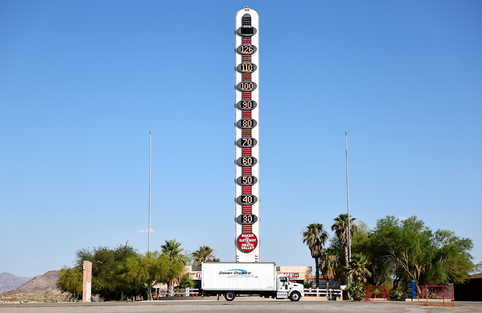

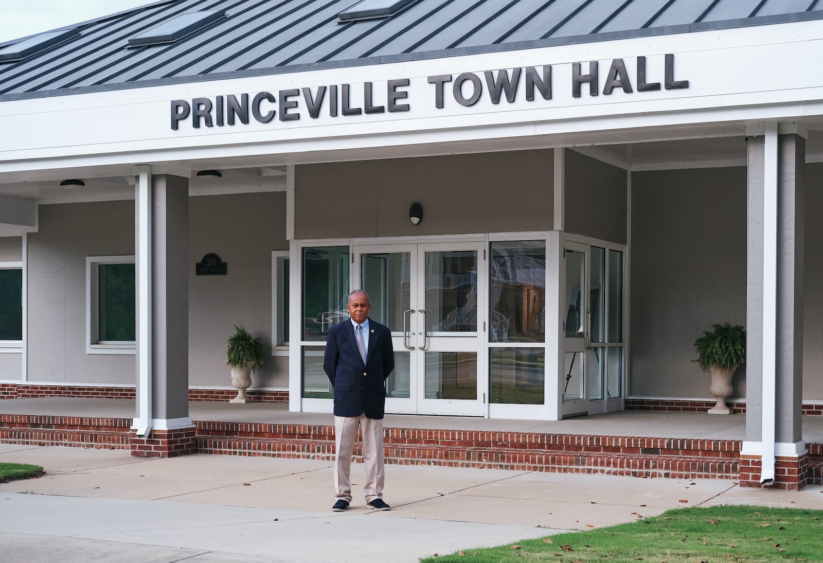
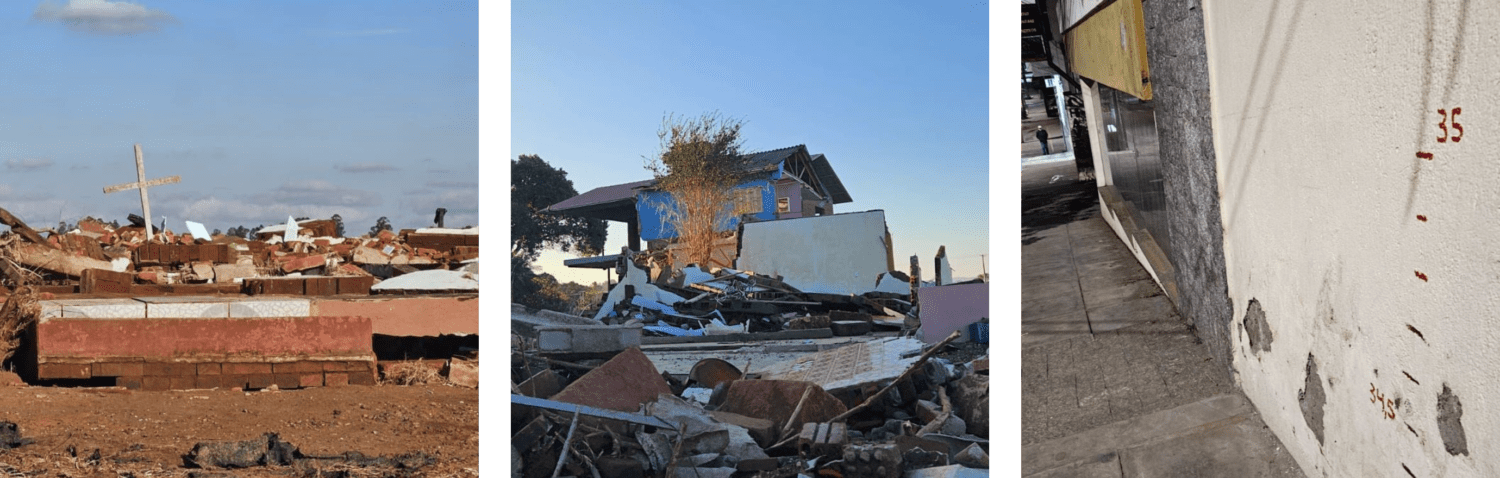
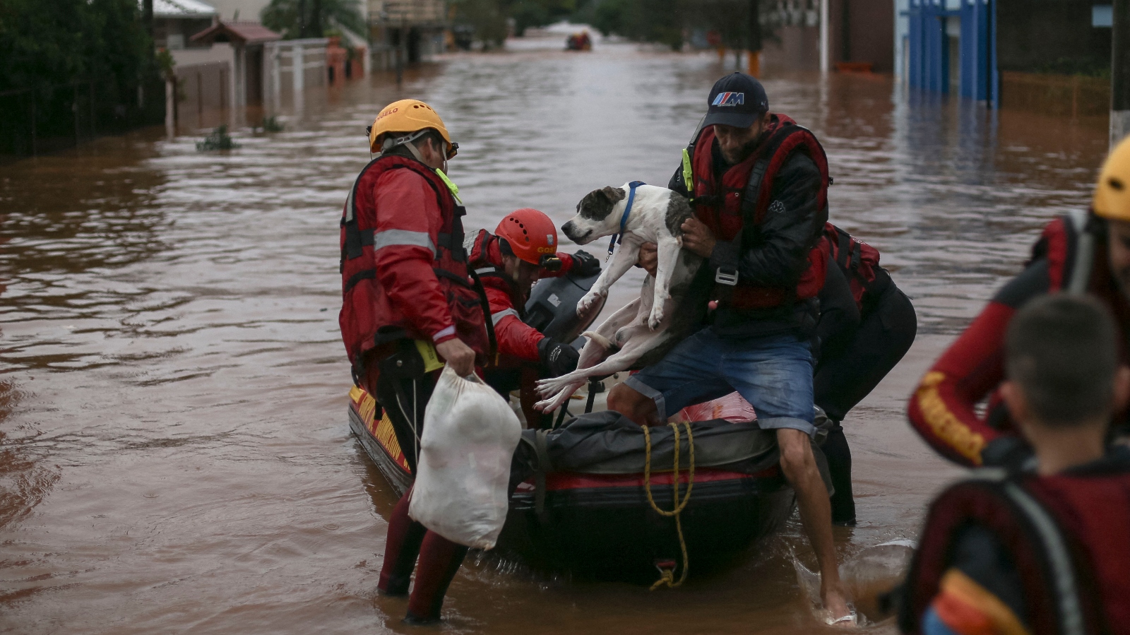
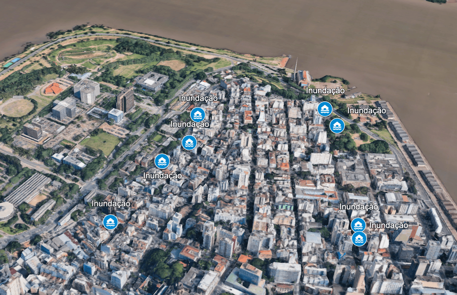
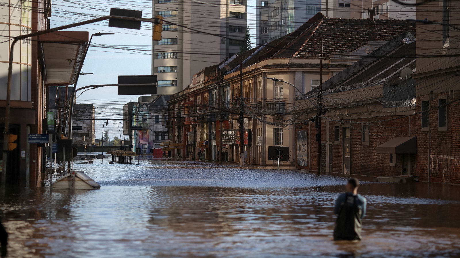
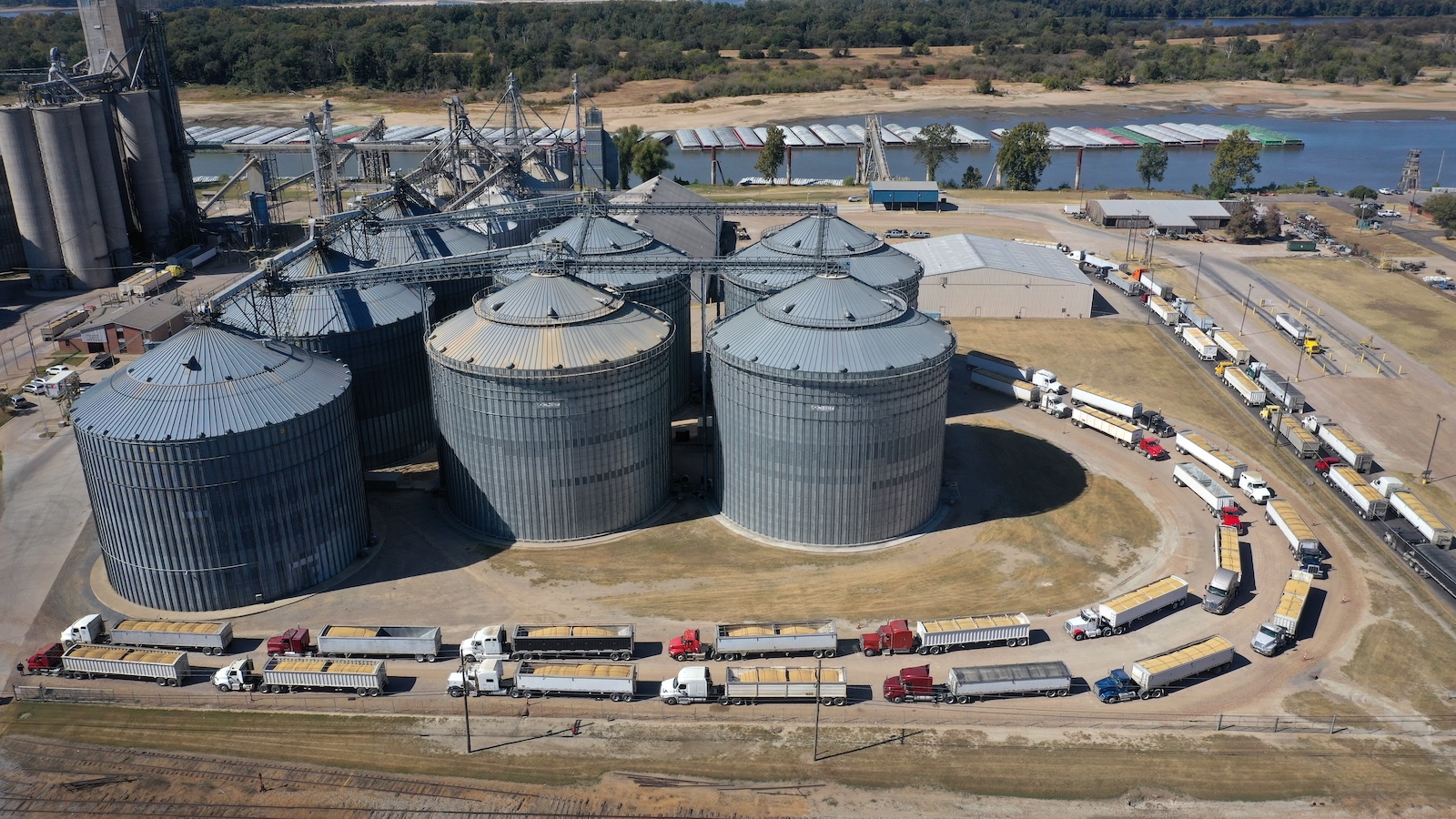
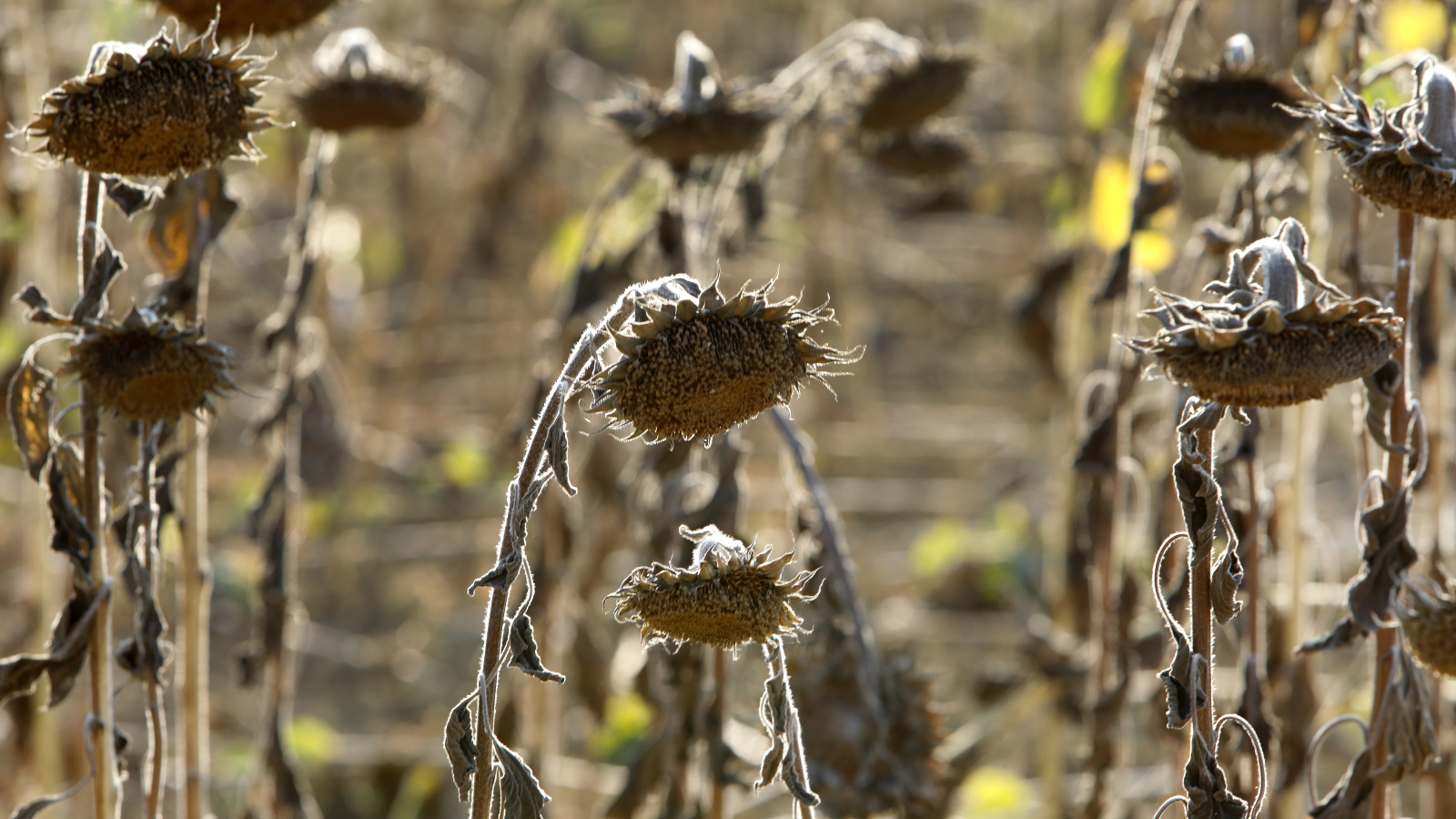
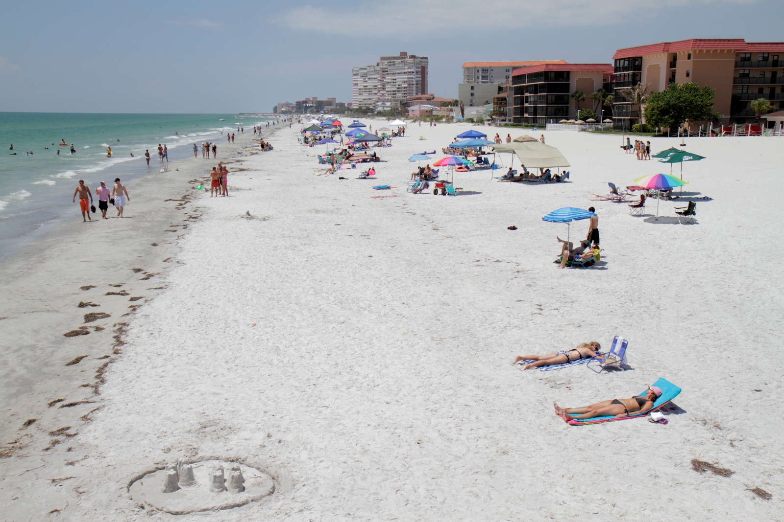
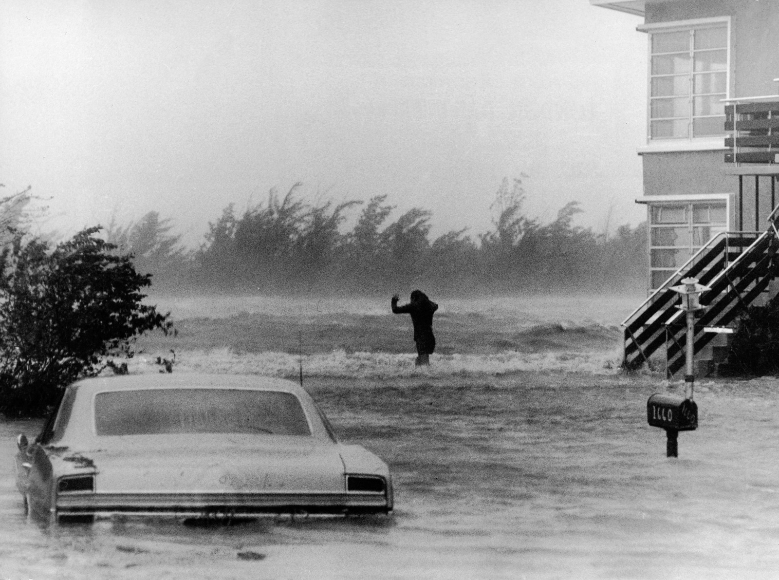
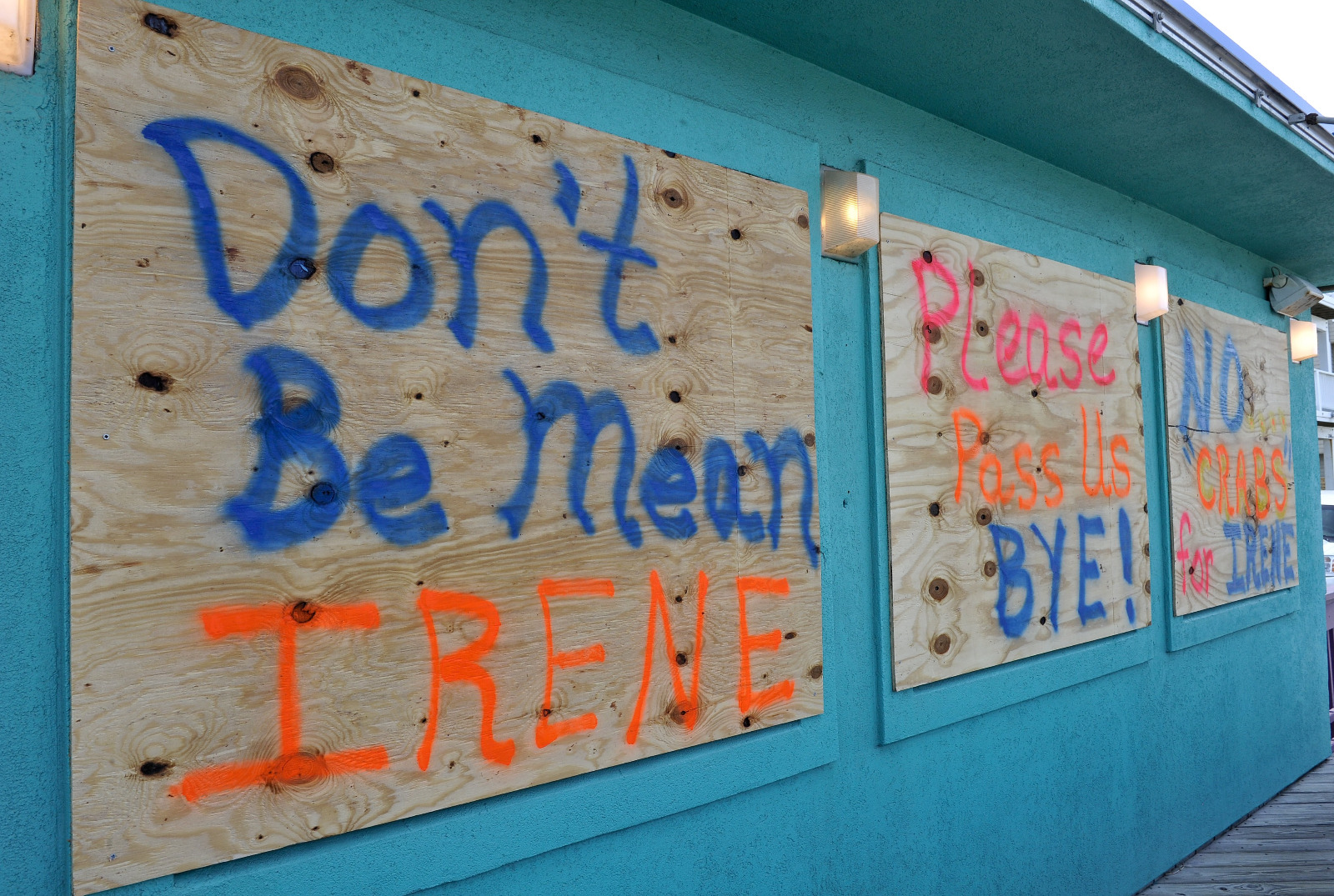
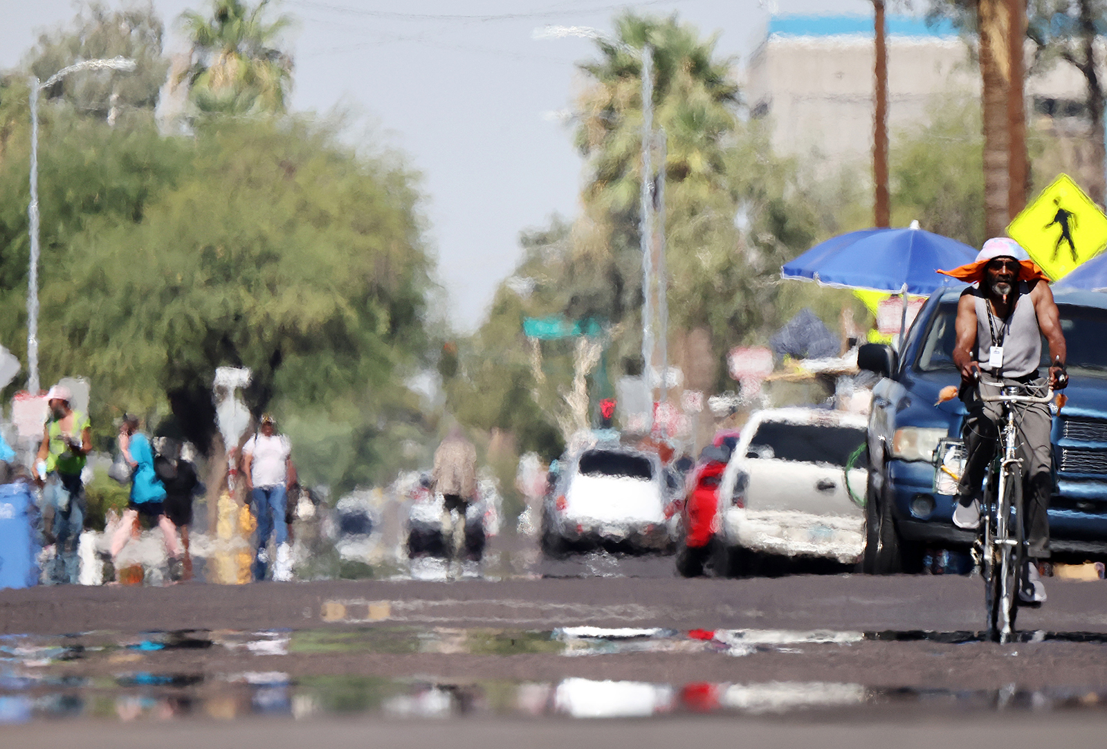


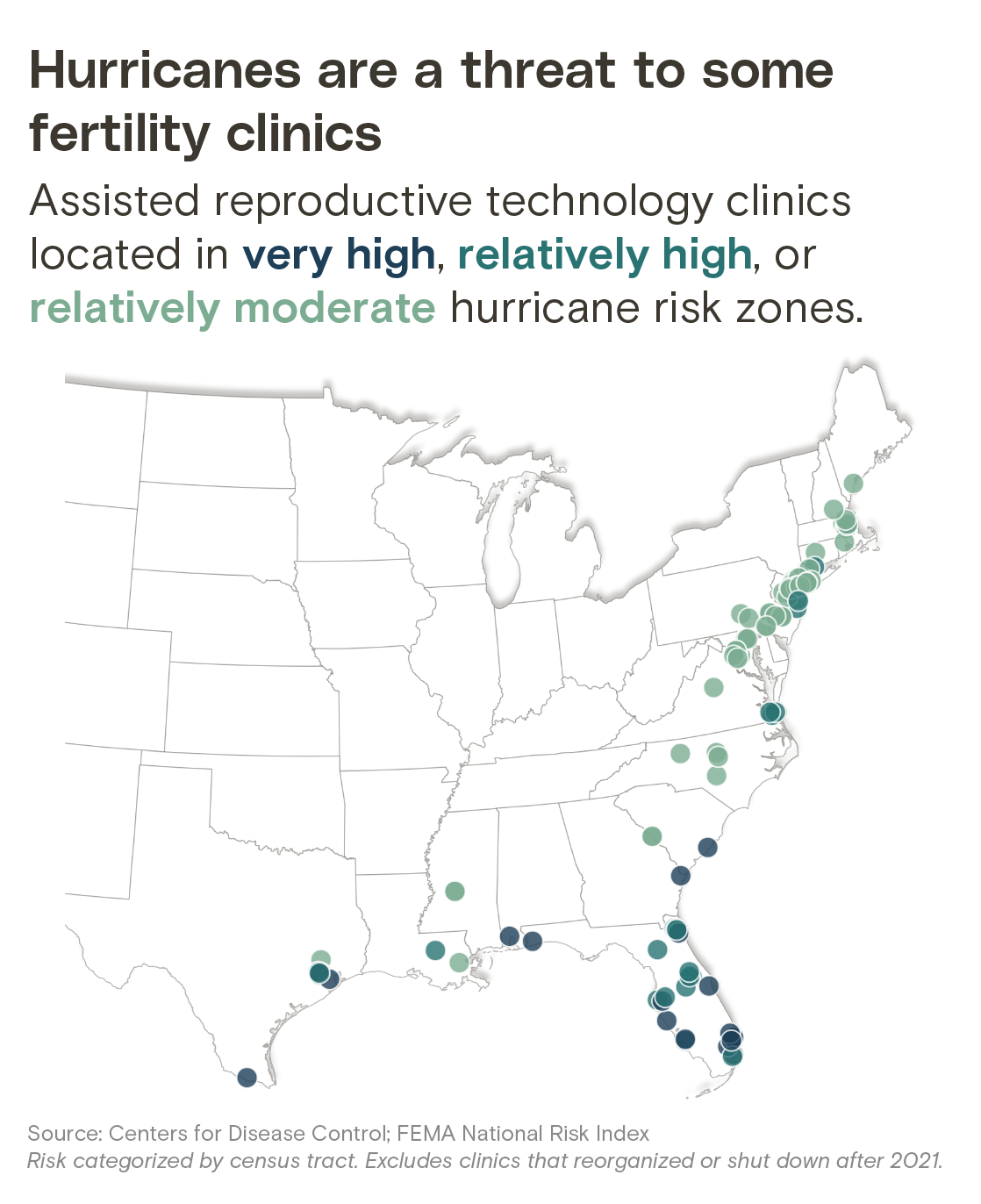
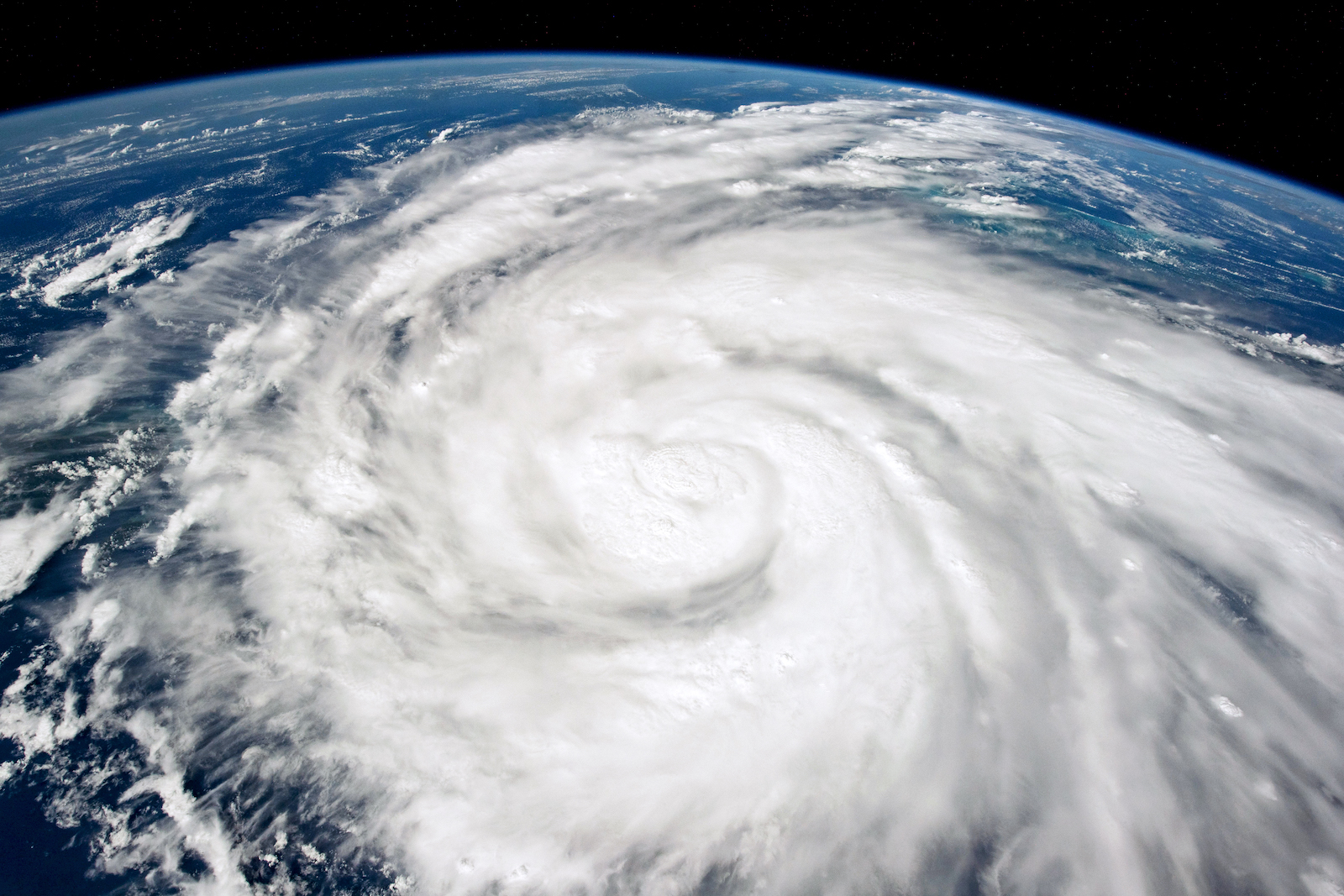

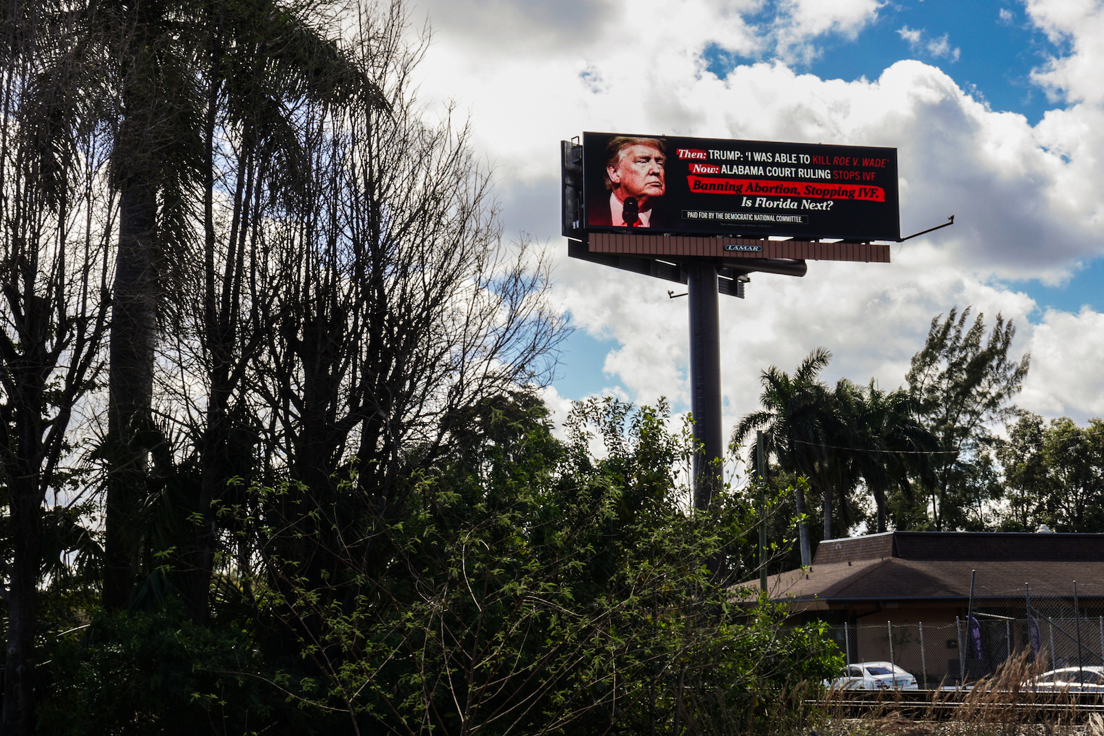
