Category: Extreme weather

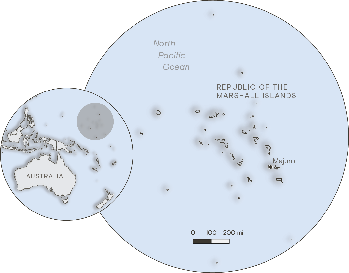
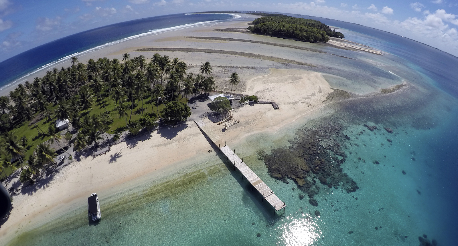
  • The Marshall Islands extend across a wide stretch of the Pacific Ocean, with dozens of coral atolls sitting just a few feet above sea level. The smallest of the islands are just a few hundred feet wide, barely large enough for a road or a row of houses. The country’s total landmass makes up an area smaller than the city of Baltimore, but it occupies an ocean territory almost the size of Mexico.  

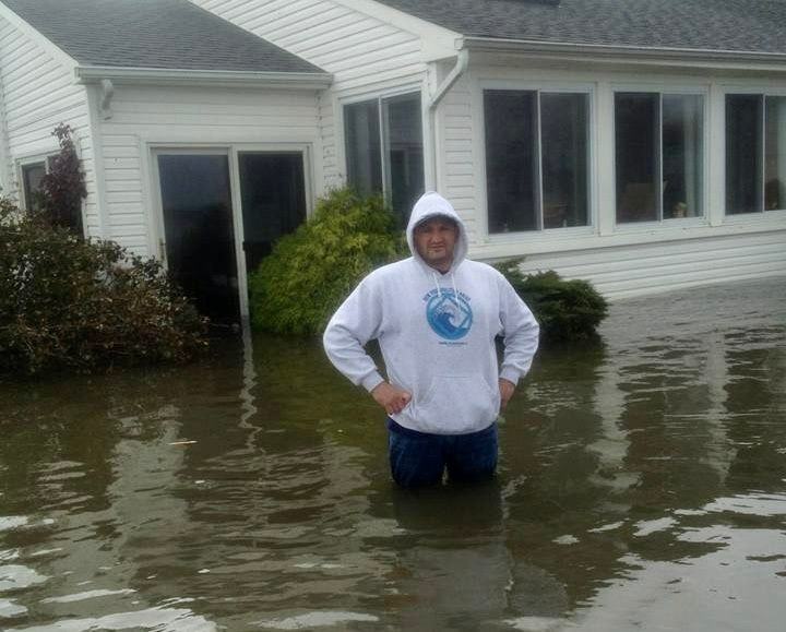
    Over the past two years, government officials have fanned out across the country, visiting remote towns and villages as well as urban centers like its capital of Majuro to examine how Marshallese communities are experiencing and coping with climate change. They found that a combination of rapid sea-level rise and drought has already made life untenable for many of the country’s 42,000 residents, especially on outlying atolls where communities rely on rainwater and vanishing land for subsistence. 

    A locator map showing the Republic of the Marshall Islands. The archipelago of atolls appears northeast of Australia in the North Pacific Ocean.
    Grist / Clayton Aldern

    The survey was part of a groundbreaking, five-year effort by the Marshall Islands to craft a sweeping adaptation strategy that charts the country’s response to the threat of climate change. The plan, shared with Grist ahead of its release at COP28 in Dubai, calls for tens of billions of dollars of new spending to fortify low-lying islands and secure water supplies. Representatives from the Marshall Islands say the plan shows that their country can remain livable well into the next century — but only if developed countries are willing to help. Even with aid, the plan concedes many Marshallese will likely need to migrate away from their home islands, or even leave the country altogether for the United States, as climate impacts worsen.

    We call it our national adaptation plan, but it is really our survival plan,” said John Silk, the foreign minister of the Republic of the Marshall Islands, during a closed-doors panel conversation at the Clinton Global Initiative summit in New York in September.

    an aerial photo of a doc and beack with rocks under water
    An aerial photo of Majuro Atoll in the Marshall Islands, showing land that has slipped below the water line. The country faces almost two feet of sea-level rise by the end of the century. Rob Griffith / AP Photo

    Other vulnerable countries have submitted adaptation plans to the United Nations before, and some have even planned large-scale relocations to escape sea-level rise, but the Marshall Islands plan is different, and not only because of the existential nature of climate risk in the country. As they developed the plan, government officials interviewed more than 3 percent of the country’s population — some 1,362 people — during 123 days of site visits on two dozen islands and atolls. The only other national adaptation plan that has involved any community participation was that of the island nation of St. Lucia, in the Caribbean. In that case, officials interviewed only 100 people.

    “We’re about to make a huge change to our islands, and we can’t do that if we just make that decision unilaterally as government representatives,” said Kathy Jetn̄il-Kijiner, a poet and activist who serves as the Marshall Islands’ climate envoy, in an exclusive interview with Grist ahead of the plan’s release. “It has to come from the community themselves too, because they’re the ones getting impacted.”

    Experts who reviewed the plan described it as among the most comprehensive attempts by any country to plan for long-term climate impacts.

    “This is one of the most thoughtful and meticulous long-term adaptation plans I’ve seen,” said Michael Gerrard, a law professor at Columbia University who has studied climate adaptation policy, including the Marshall Islands. “The plan doesn’t just wring hands; it sets forth a systematic decision-making process.”

    Two women walk along a rocky sea shore
    Climate change activist Milan Loeak, left, walks along the shore of Majuro Atoll with poet Kathy Jetn̄il-Kijiner, who serves as the Marshall Islands’ climate envoy. Rob Griffith / AP Photo

    Almost half of the Marshall Island residents interviewed for the plan said they’d witnessed sea-level rise in their communities, and nearly a quarter said they’d experienced a water shortage. More than 1 in 5 said climate change had threatened food security for their households.

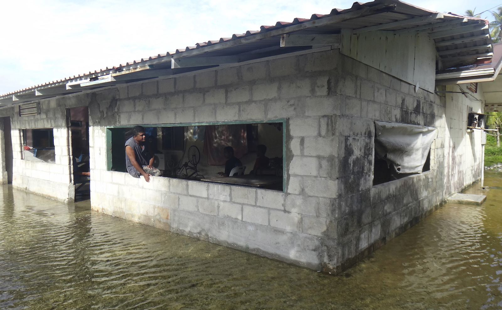
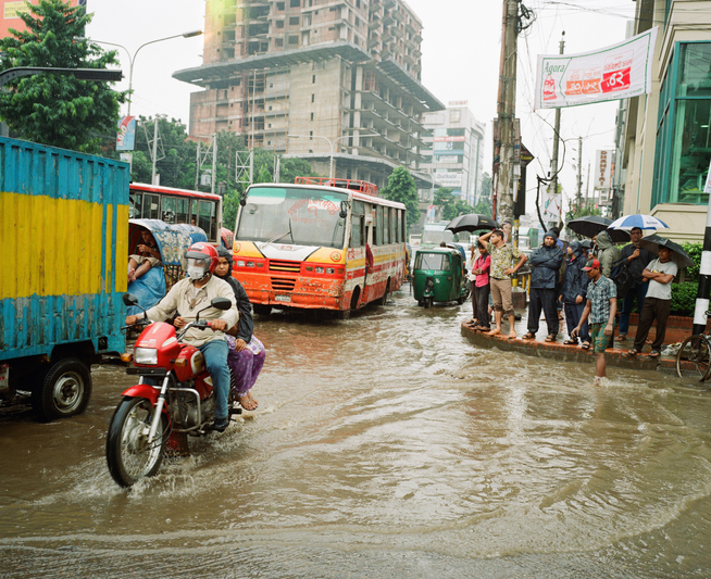
    The rural, northern island of Wotho, for example, has long served as a “food basket” for the rest of the Marshall Islands. But officials found that a slew of disasters has jeopardized life there. Houses flood with every high tide, the airstrip goes underwater during big storms, household wells pull up salty water, salt-scourged breadfruit trees produce rotten fruit, and fish have abandoned bleached coral reefs. 

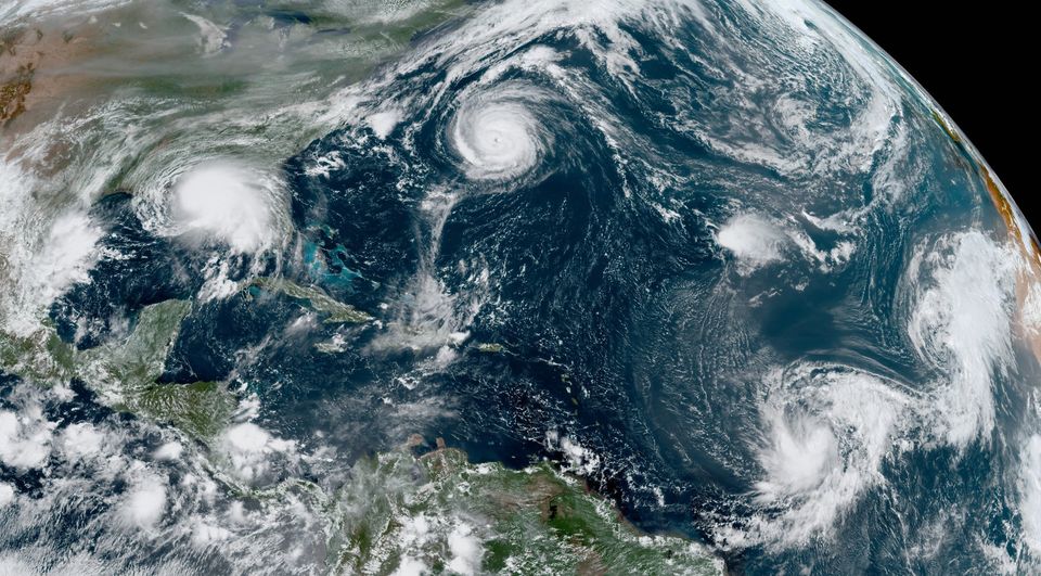
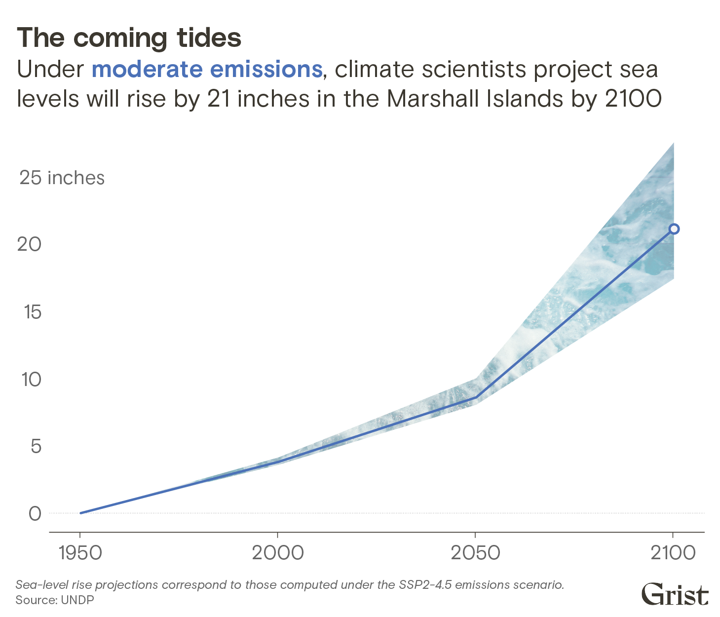
    Science predicts it will only get worse. Even under the most optimistic projections, which assume immediate action to limit global warming, the Marshall Islands will experience almost two feet of sea-level rise before the end of the century. That’s enough to expose thousands more Marshallese citizens to constant flooding and extreme food and water insecurity, rendering some of the country’s islands all but unlivable. Under the worst projections, which predict more than six feet of sea-level rise by 2150, many islands and atolls would disappear underwater entirely.

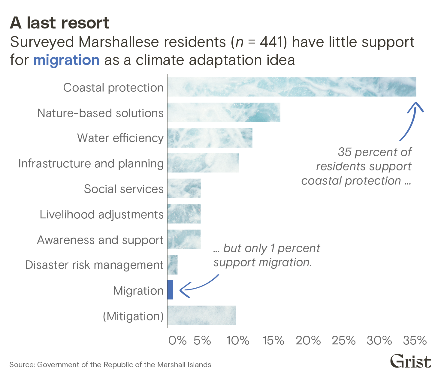
    Even so, the community engagement process revealed that migrating away from their home islands is anathema to almost all Marshallese. More than 99 percent of interviewed residents rejected the idea of migration — as one respondent put it to an interviewer, “We will die here.”

    A bar chart showing the results of a climate adaptation preferences survey posed to residents of the Marshall Islands. 35 percent of residents support coastal protection, while only 1 percent support migration.
    Grist / Clayton Aldern

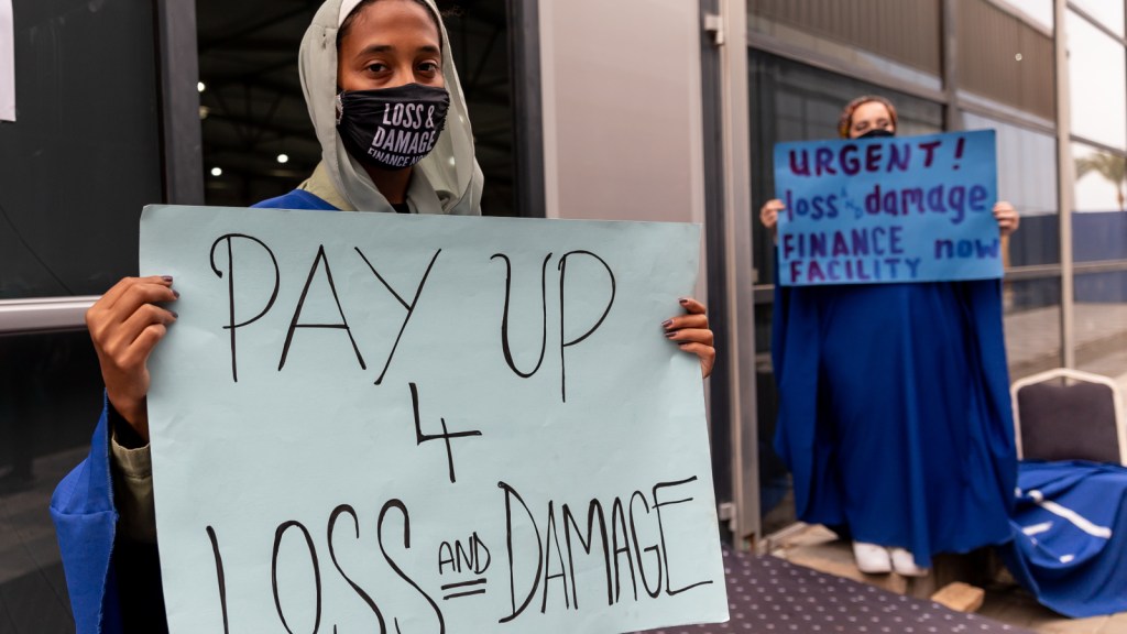
    The plan arrives as climate negotiators at COP28 debate major new funding commitments to help developing countries adapt to climate change and deal with climate losses. Leaders from the Marshall Islands say their plan highlights the urgent need for billions of dollars of new adaptation funding from developed nations. In other parts of the world, adaptation means the difference between bad impacts and worse impacts. In the Marshall Islands, successful adaptation means the difference between survival and extinction.

    “My hope for my own home is that it remains here long enough for me to give back to the land,” said Jobod Silk, a youth climate representative from the Marshall Islands who conducted community interviews for the plan. “I hope that we remain on our land, that we remain sovereign, and that we’re never labeled as climate change refugees.”


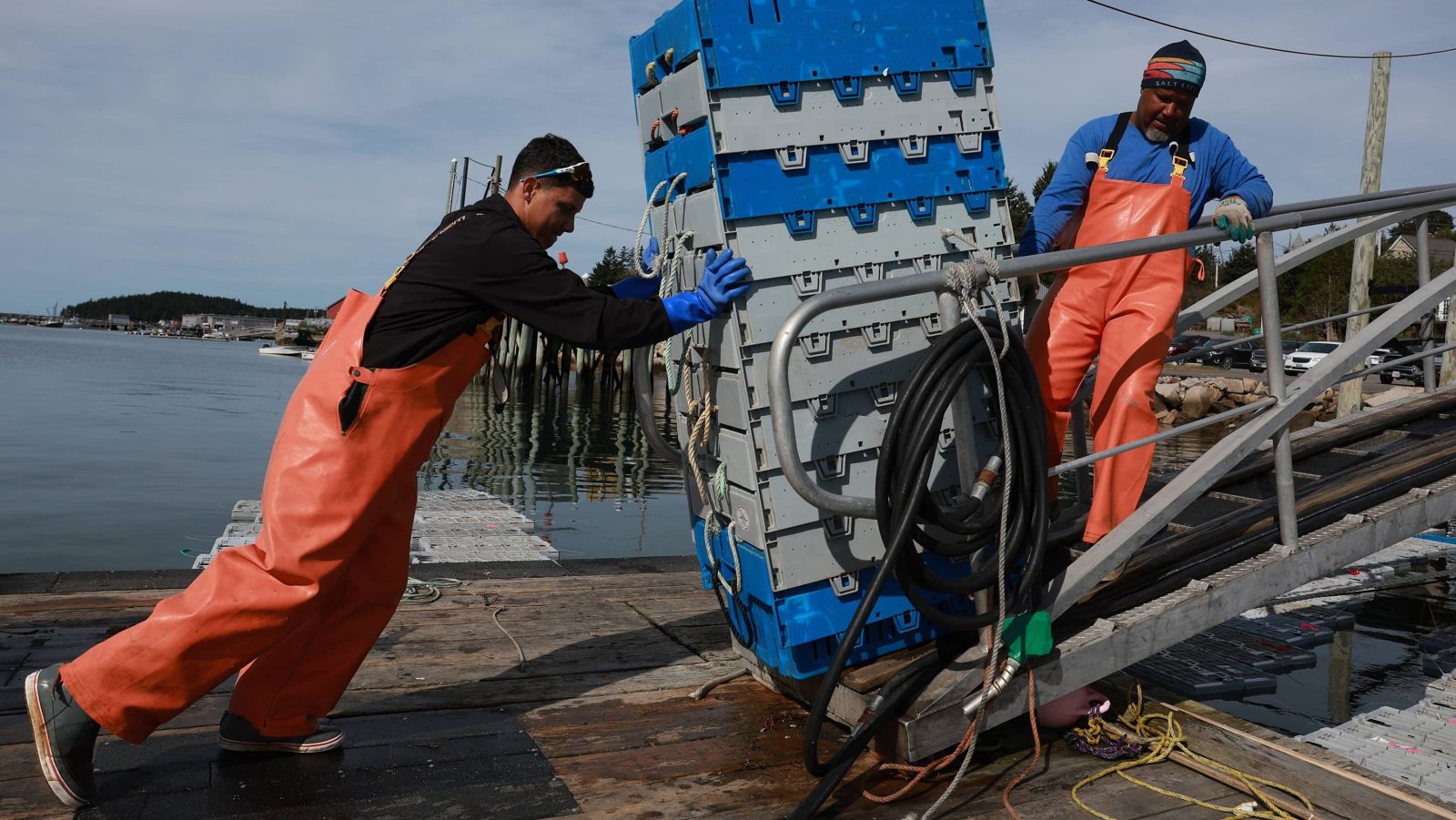
    Climate change is not the first time residents of the Marshall Islands have dealt with environmental devastation. After the United States defeated Japan in World War II, it took control of the country through a trust backed by the United Nations. Over the course of a decade, the U.S. dropped more than 60 nuclear bombs on Bikini Atoll and other islands as part of a secretive weapons testing program. The fallout from these tests poisoned the water on nearby islands and caused higher rates of cancer and birth defects for many Marshallese. Fish near the U.S. military base on Kwajalein Island have been found to contain dangerous levels of polychlorinated biphenyls, or PCBs.

    A mushroom cloud rises over Bikini Atoll in the Marshall Islands as part of a nuclear weapons test conducted by the United States in 1946. The U.S. dropped dozens of nuclear bombs on the Marshall Islands over the span of a decade. Pictures from History / Universal Images Group via Getty Images

    Now, a generation later, sea-level rise and drought are again disrupting life for many Marshallese, threatening the homes and health of families that fled nuclear fallout just a few decades ago. Even before the development of the new adaptation plan, many residents of vulnerable villages had already started to alter their behaviors to cope with the new reality of climate change. During site visits to outlying atolls, Marshallese officials witnessed residents of one island constructing makeshift seawalls out of trash. They found that fishermen on another island had started to fish as a collective in waters where reefs have degraded and fish stocks have plummeted, combining their efforts so that they catch enough food for their entire community. 

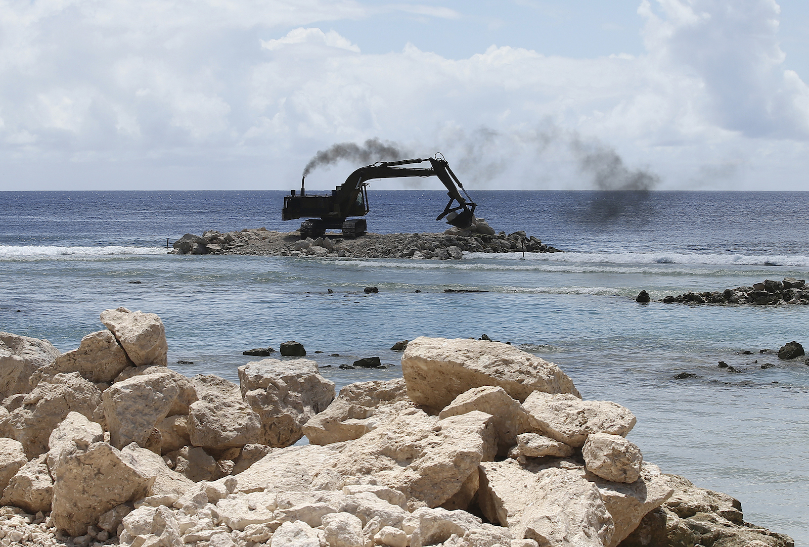
    In the short term, the new plan proposes to support these community-led adaptation efforts with billions of dollars of new money from other countries. U.N.-backed programs have already helped deliver rainwater-harvesting devices to outlying islands and build vertical vegetable gardens on others. With more money, the Marshallese government says it could expand air and sea shipments to these small islands to ensure a supply of substitute food, or provide canoes to every household as alternate transportation when roads are flooded. The plan defers to residents of outlying atolls by emphasizing what it calls “low-technology community initiatives and nature-based solutions” over engineered interventions like seawalls and dikes.

    An exxcavator sits on a shallow part of the ocean with rocks in the foreground
    An excavator moves rocks and sand to aid in the construction of seawalls around the airport on Majuro Atoll in the Marshall Islands. Rob Griffith / AP Photo

    “This document is a self-determined document,” said Broderick Menke, an official at the Marshall Islands climate change directorate who served as the technical expert on the plan. “It’s not just the government making points, and it’s not just a consultant making decisions and providing answers. The roots of all of this is us coming together as the community and talking.”

    In order to pursue these adaptation measures, the government will need to contemplate changes to the system of land ownership in the Marshall Islands. The country has almost no public land, and families pass down their properties along matrilineal lines, so the government can’t unilaterally build seawalls or set aside coastal areas for conservation, and disrupting this land tenure system would involve difficult conversations with traditional island leaders. The country also needs to update its environmental regulations and building codes in order to implement its short-term adaptation push.

    A man sits in the window of a cinderblock home with flood waters all around
    A man sits on the window sill of his flooded house during a king tide event on Kili Atoll. Towns and cities in the Marshall Islands now experience routine flooding during high tide. Jack Niedenthal / AP Photo

    Marshallese leaders say they can overcome these obstacles, and they stress that a fully funded portfolio of solutions would protect even the country’s most vulnerable islands for decades to come. But the plan also contains a grim warning that these adaptation efforts will not be able to protect the entire country indefinitely against future sea-level rise.

    “The adaptation pathway for sparsely populated neighboring atolls and other islands comes down to buying time until sea level rise and other climate change impacts render the islands uninhabitable,” the plan says.

    In addition to identifying adaptation strategies for droughts and flooding, the authors of the plan also had to create a procedure for deciding when and how to give up on protecting vulnerable areas. To that end, the plan lays out a phased “pathway” for adaptation, with “decision points” arriving over the next century as climate impacts worsen. This framework focuses attention and funding on short-term triage for vulnerable outlying islands like Wotho, and defers big decisions about the country’s future until later decades.

    The first phase of the plan calls for the government to do everything possible over the next 20 years to protect vulnerable islands, leading up to a “decision point” some time between 2040 and 2050. When that point arrives, if it seems like climate change is going to overwhelm these islands despite adaptation efforts, officials must make a “decision regarding which atolls to protect and consolidate social services.” This wouldn’t involve moving any people or even buildings, but it might mean reducing government investment in education and health services. 

    A few decades later, in 2070, the plan calls for an even more difficult decision — officials must “decide which pieces of land are to be protected for the long term” and “build the protection infrastructure … to accommodate relocated populations.” In a sign of the dire outlook for future sea-level rise, the plan suggests choosing as few as four pieces of land for future investment, out of the 24 inhabited islands and atolls in the country right now.

    Ebeye in Kwajalein Atoll, Marshall Islands, is one of the most densely populated islands in the Pacific.
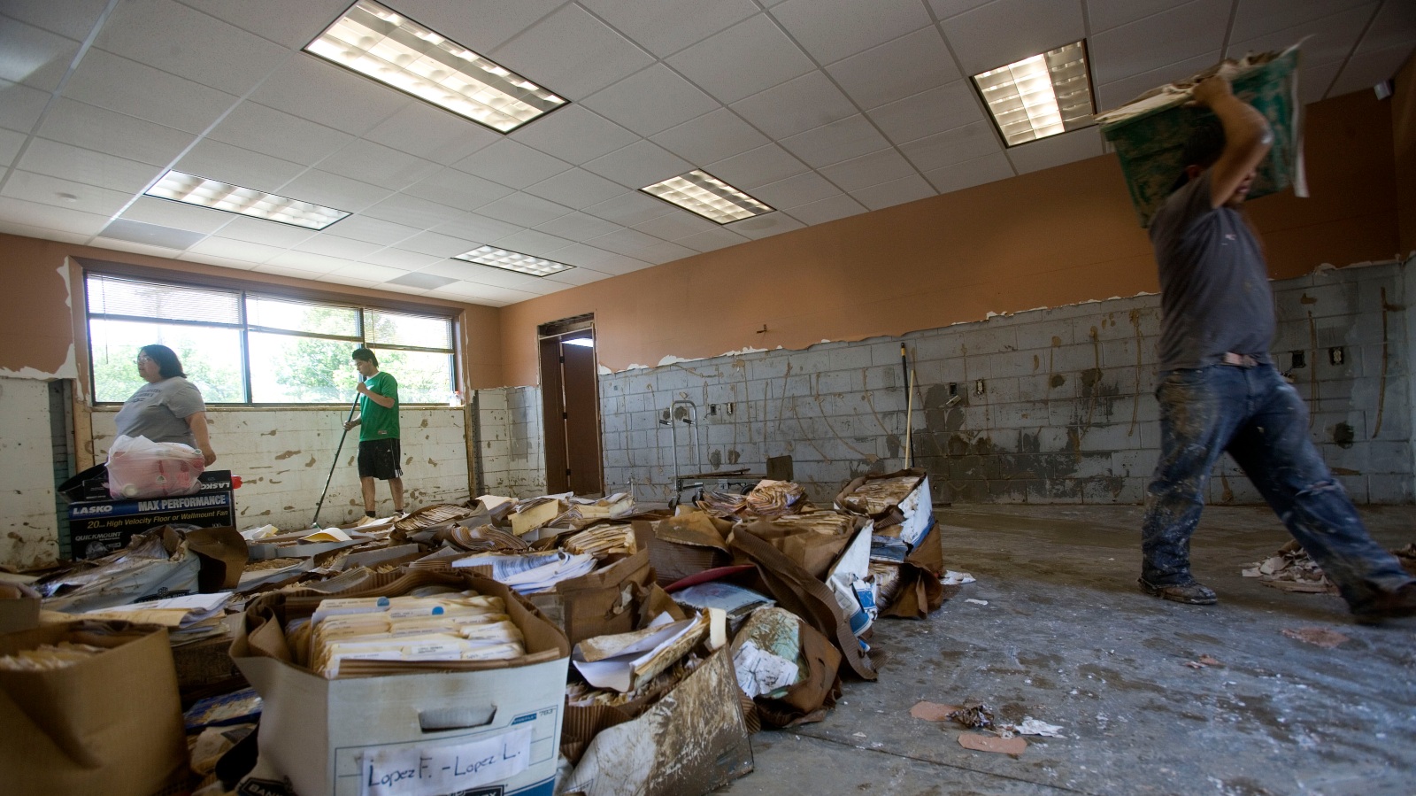
    Brandi Mueller / Getty Images

    Adaptation experts said the Marshall Islands is one of the first countries to develop a long-term plan for relocating whole segments of its population.

    “This is a noteworthy step in adaptation planning,” said Rachel Harrington-Abrams, a researcher at King’s College of London who studies relocation in vulnerable island states. She said the plan is the first from an atoll country like the Marshall Islands that “support[s] in situ adaptation while also enabling long-term planned relocation.” Harrington-Abrams added that island states such as Fiji and Vanuatu have planned to move vulnerable populations to higher ground, but these states have far more solid land than the Marshall Islands does.

    The most likely candidates for long-term protection are Majuro and Ebeye, the country’s two main urban hubs. Together, these cities are already home to more than 70 percent of the Marshall Islands’ population, making them some of the most densely populated places in the Pacific. The plan predicts that further migration from rural islands to these cities is “very likely.” 

    But these urban hubs, too, are extremely vulnerable to sea-level rise: Even two feet would flood around one-third of Ebeye’s atoll and almost half of Majuro’s. If the government decides to stop protecting rural islands and retrench on the urban ones, it must also fortify these cities so that they can withstand future flooding. The country would begin by investing billions of dollars into new seawalls, dikes, drainage systems, and home elevations, as well as desalination machines and water treatment facilities to cope with saltwater intrusion. A new water treatment plant was installed on Ebeye in 2020 with support from the Australian government and the Asian Development Bank, giving residents of the city reliable access to clean running water for the first time.

    People help clean up debris after a 2021 high-tide flood event in Majuro, the capital of the Marshall Islands. The flood event pushed sand and debris over the only road that leads to the Majuro airport. Chewy Lin / AFP via Getty Images

    Full protection against six feet of sea-level rise would require a much more radical adaptation strategy. The plan calls for the government to raise entire segments of land on Majuro and Ebeye by as much as 12½ feet, high enough to escape not only rising tides but also groundwater penetration. In addition to raising the existing cities, the country would also need to construct new reclaimed land by dredging the ocean floor. The plan projects that a new landmass to accommodate 10,000 people would need to be about 1.4 square miles, or a little larger than New York’s Central Park. 

    This type of land construction project has already been undertaken in the Maldives, which built an artificial island called Hulhumalé in the early 2000s to prepare for sea-level rise. That island is now home to more than 50,000 people. But the remoteness of the Marshall Islands, and the “technical feasibility” of land construction there, would likely drive the cost of such a construction project into the billions.

    The last and most painful decision point, Marshallese officials found, will arrive at the year 2100. By that point, without massive investment in adaptation, many parts of the country will likely have become uninhabitable. The plan calls for leaders to make a profound choice about the future existence of the Marshall Islands itself.

    “If by 2100, no decision can be made to protect areas of atolls to the [six-foot] sea level rise level, or if there is no funding for it, then the decision must be to help all population to migrate away from RMI,” or the Republic of the Marshall Islands, the plan says.

    A line chart showing sea-level rise projections for the Marshall Islands under a moderate emissions scenario. By 2100, climate scientists expect local sea levels to rise by 21 inches.
    Grist / Clayton Aldern

    The most likely destination for these departing residents would be the United States: The Marshall Islands declared independence from the U.S. in 1979 but later signed a “compact of free association” with the country, allowing Marshallese residents unrestricted migration to the United States. In exchange, the U.S. exerts significant control over Marshallese waters and airspace, giving it a strategic military foothold in the Pacific.

    The country’s population has already fallen by around 20 percent over the past decade as many citizens leave seeking jobs and education in the U.S. The majority of these migrants have settled in Oregon, Washington, and Arkansas. More than 12,000 have settled in the city of Springdale, Arkansas, alone. The city now holds annual Marshallese festivals and cultural events.

    The creators of the plan emphasize that international migration is an absolute last resort, and one that the overwhelming majority of Marshallese residents oppose. During the government’s hundred-plus community meetings, fewer than 1 percent of interviewed citizens expressed support for migration as a climate adaptation strategy, indicating an almost total rejection of relocation policies. The plan doesn’t go into detail about how to implement such policies, or about how the Marshall Islands’ government could provide support or restitution for residents who have to move.

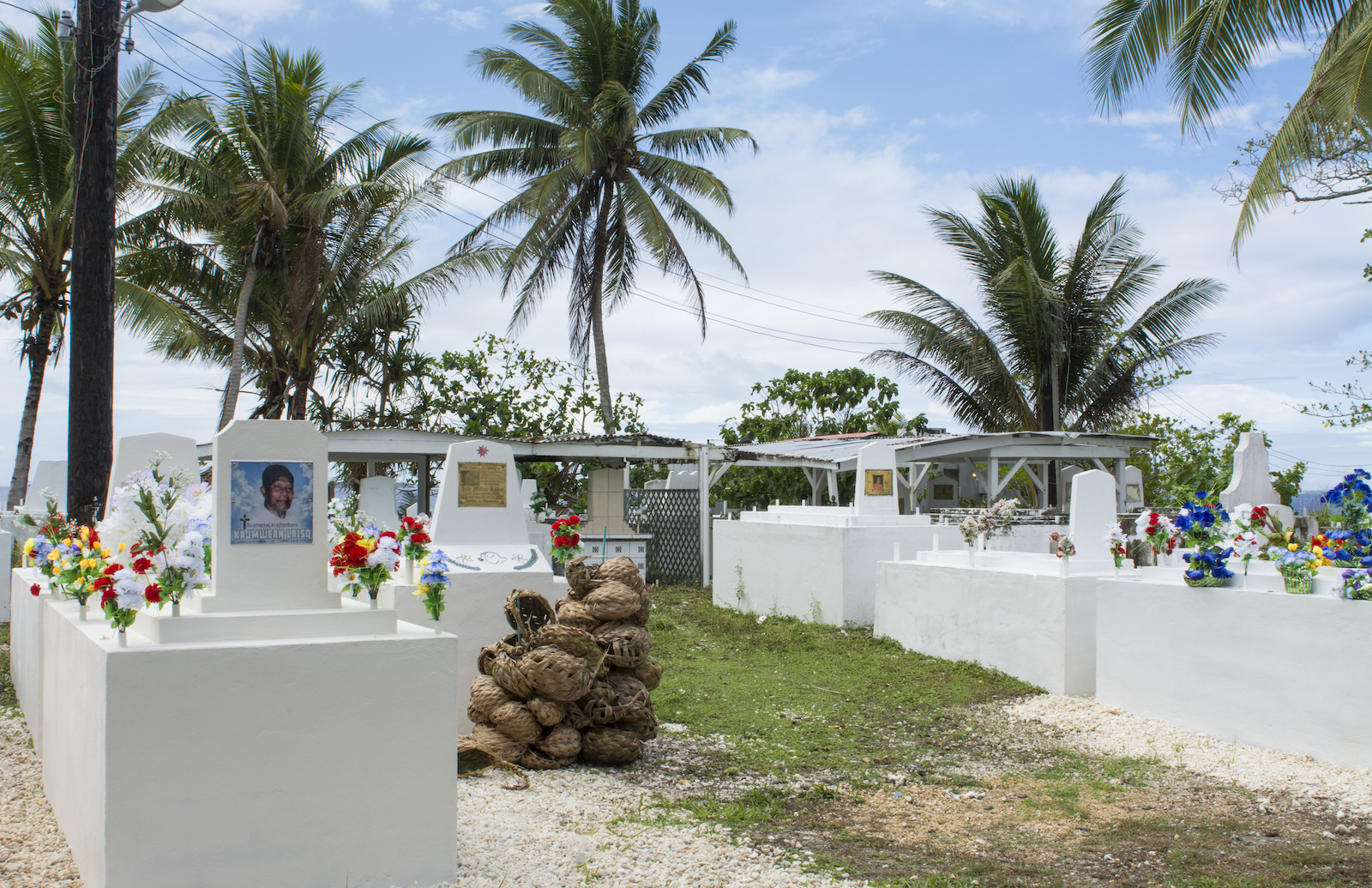
    The losses that will accompany this migration are impossible to quantify, said John Silk, the foreign minister, at the panel in September. A large-scale relocation would make it impossible for many Marshallese to be buried on their home islands, a key part of Marshallese culture, and it would further erase Indigenous navigation methods that Marshallese sailors have used for millennia. 

    “Loss to us is not just a financial loss or an economic loss; it’s a cultural loss if people have to migrate from their own home island to another place,” Silk said at the panel. “Even if you go to another part of the Marshall Islands, and you build a seawall, and we bring our people there, they will never feel at home, because they’re not.”

    a cemetery with photos of people on the stones and palm trees in the background
    Photos of people decorate gravestones at a cemetery in Majuro, the capital of the Marshall Islands. Education Images / Universal Images Group via Getty Images

    Despite the pain that would accompany such a large migratory movement, the creators of the adaptation plan view the plan as an optimistic document. If the Marshall Islands’ government can raise the money it needs for adaptation, it could also address some other challenges the country is already facing. It could bolster social services and health outcomes on rural outlying islands, reversing the trend of population loss and the rapid growth of Majuro and Ebeye. Such an investment in infrastructure and social resilience might even help stem the tide of out-migration to the United States.

    “I think you can go even a step further, to bringing back the migrants that are going out of the Marshall Islands,” said Menke, the technical expert on the plan. “Marshallese go out there [to the United States] for education and for all these other services, but you know, they just have a … feeling of being away from home.”

    The cost of achieving that future could run to an astonishing $35 billion, according to the plan, equivalent to around $800,000 for every current resident of the Marshall Islands. And the country needs to raise that money sooner rather than later, since the cost of adaptation will only increase as time goes on and climate impacts worsen.

    A large UN seal in a gold room under which a man in a suit speaks at a podium
    Marshall Islands president David Kabua addresses the United Nations General Assembly in September of 2023. The country has become a leading advocate for international climate aid from developed countries. Frank Franklin II / AP Photo

    Much of this money would need to come in the form of direct aid from rich countries like the United States, but the Marshall Islands could pull down some of it through international adaptation funds like the Green Climate Fund, or through multilateral development institutions such as the World Bank. If these aren’t enough, leaders may also need to pursue alternative financing mechanisms like an international tax on maritime shipping emissions, which the Marshall Islands and the Solomon Islands proposed in 2021

    Even so, rich countries aren’t currently providing anywhere near enough adaptation finance to fund the entire plan, said Rebecca Carter, the lead adaptation researcher at the World Resources Institute, an environmental research nonprofit.

    “If it was just the Republic of Marshall Islands, maybe there would be enough, but when we start multiplying their numbers by how many other places are facing similar threats, that’s when it becomes really untenable,” she told Grist.

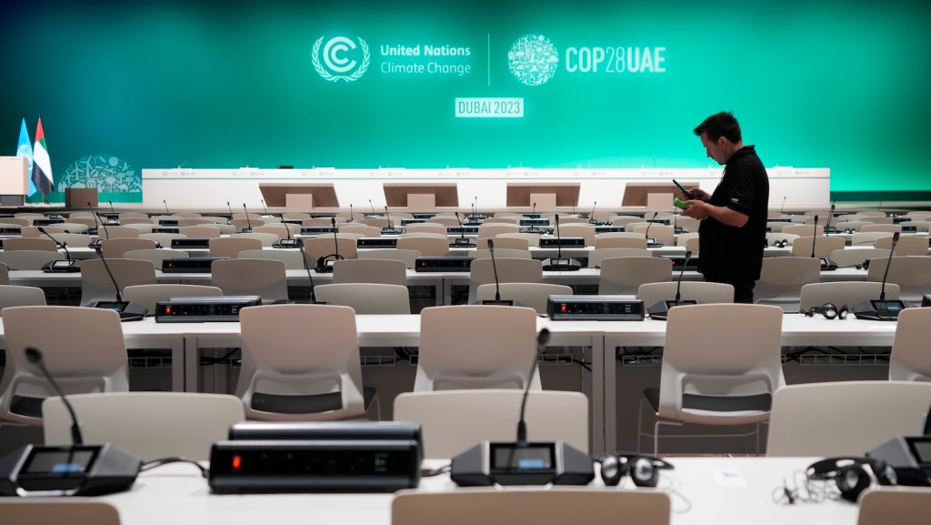
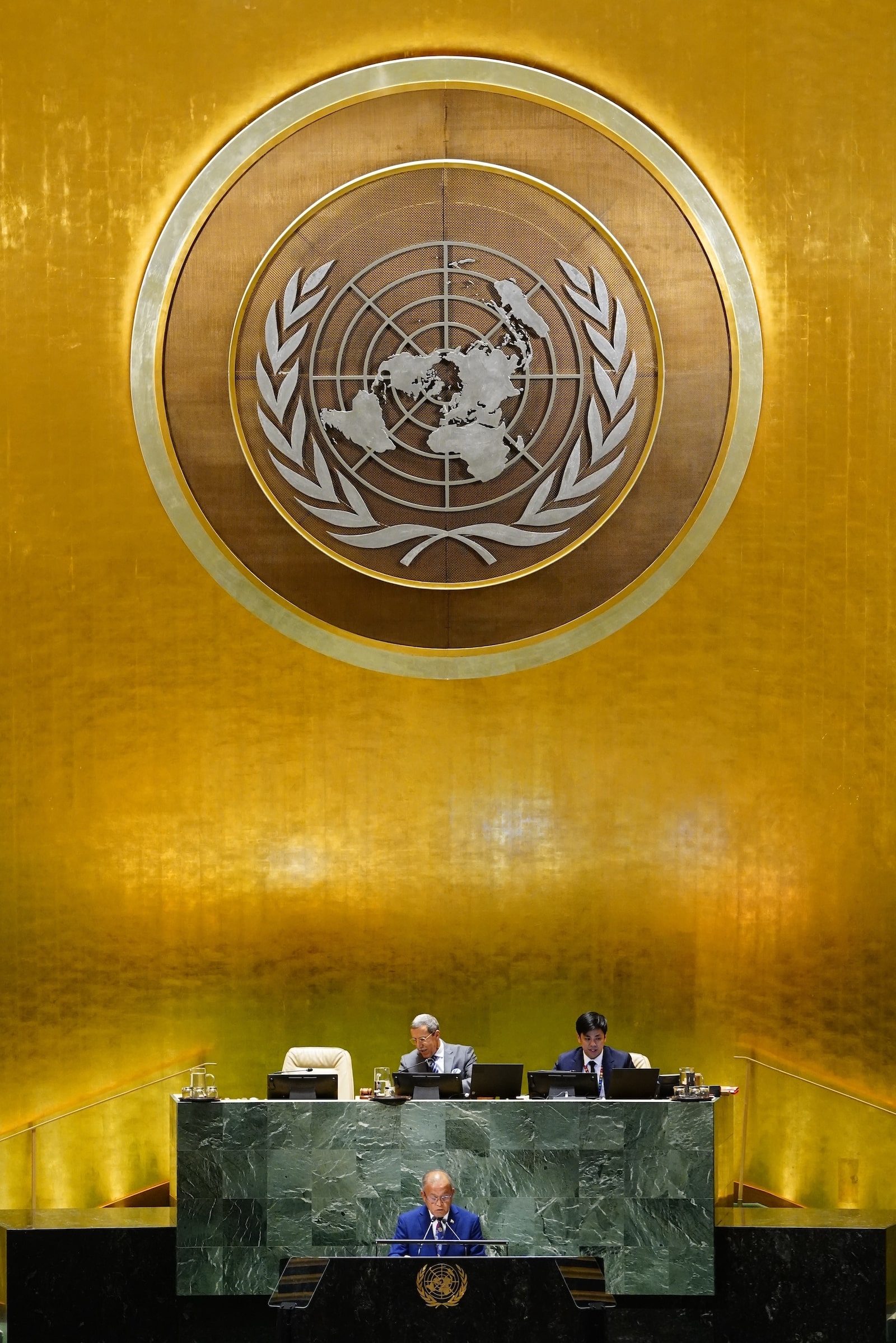
    Leaders from the Marshall Islands hope their plan helps sway the international negotiations underway in Dubai. Negotiators are currently debating how much money developed countries should send poorer countries for climate adaptation, as well as how to measure the success of adaptation projects. The Marshall Islands’ in-depth adaptation plan shows both the urgent need for new funding, as well as the need to develop adaptation solutions in concert with affected communities, Jetn̄il-Kijiner says.

    “I hope that it sheds light on the importance of adaptation and what communities like ours are being forced to plan for,” she said. “We’re trying to set a standard for how to engage with your own community and how to plan for these types of impacts.”

    As the consequences of climate change in the Pacific grow more severe, the Marshall Islands and other small island states have become a leading force in international climate negotiations. The late Tony de Brum, a long-serving minister for the Republic, was a key architect of the Paris Agreement, and subsequent Marshallese leaders have pushed for even more ambitious mitigation targets, as well as big funding commitments for adaptation and climate reparations. (The country accounts for around .00001 percent of historical greenhouse gas emissions.)

    Now Jetn̄il-Kijiner says the country’s adaptation plan could provide a blueprint for other countries facing down the threat of climate change. Instead of just assessing future risk or selecting infrastructure projects, leaders in the Marshall Islands used the planning process as an opportunity to deepen the bonds between the government and its citizens. They say the plan shows that it’s possible to pursue adaptation from the bottom up, rather than the top down.

    “It’s a lot of responsibility to have to hold the hand of our community and say, ‘I’m sorry to tell you, but this is something that we have to face, but it’s OK, we’re going to face it together,’” Jetn̄il-Kijiner told Grist. “I think that’s something that takes a lot of delicacy.”

    This story was originally published by Grist with the headline Inside the Marshall Islands’ life-or-death plan to survive climate change on Dec 5, 2023.

    This post was originally published on Grist.

  • This story was supported by the Economic Hardship Reporting Project.

    When hurricanes hit, it’s easy to show the damage: downed power lines, uprooted trees and destroyed houses. But when those things are removed or cleaned up, there is a more insidious damage that still lurks and is hard to portray: lack of affordable housing.

    And that hits renters in the coastal United States especially hard, according to new research from Ohio State University

    The study looks into how affordable rent is in the wake of hurricanes, weather disasters that are becoming more common due to climate change. Researchers found that after a hurricane, the number of rental units usually decreases, which leads to higher rent prices. Some states, like Florida, actually have a moratorium on rent increases after disasters — but it only lasts for a month. Meanwhile, the damages from hurricanes can sometimes take years to repair.  Other research backs that up, with one study from 2022 finding that 40 percent of rental units are in the path of disaster

    The trouble often comes because tenants are vulnerable in a multitude of ways, according to Kelsea Best, lead author and a professor of civil and environmental engineering at Ohio State University. Specifically, renters are contending with the “overlapping crises of housing affordability and climate-related disasters in the United States.”

    Another finding from the researchers: Both eviction filings and threats of eviction went up in the wake of hurricanes, which could be fueling housing instability and displacement in the wake of disasters. 

    Best also noted that the damage brought on by climate-related disasters can speed up gentrification and displace renters, especially those who are low-income. 

    Currently, renters aren’t protected by the same federal programs that protect homeowners in the wake of disasters. They can’t access the same cash grants, or be compensated fully for their items by the government since often renters don’t have receipts or a clear accounting of all of their items and how much they are worth the way that homeowners do. 

    “Our disaster safety net in this country has always prioritized property,” said Carlos Martín, project director at the Joint Center for Housing Studies at Harvard University. “We assess what you’re due in the safety net program based on damages to your property.”

    The steps that both disaster management agencies and local governments take before a disaster can often be just as important, protecting tenants from rising rents and eviction post-disaster, according to Martín. He emphasized that to ensure renters don’t experience housing instability or are pushed into homelessness, that municipalities and the federal government need to invest in affordable housing, “before the disaster hits.” 

    If aid does come to renters, they are often still stuck waiting for properties to be rebuilt. 

    “It takes a lot longer to build rental housing, aka a multifamily unit, than it does to rebuild a single family property,” said Martín. He noted that rental housing often takes four or five years to rebuild — the longest compared to other forms of housing of a similar size. By then, renters would have long moved on to other places or properties. 

    “There’s so many ways that renters are screwed,” said Martín. 

    But solutions to the problem do exist, and Martín suggests looking to the recent past to enact some of these policies. The most notable ones being eviction moratoriums and rent relief enacted at the start of the COVID-19 pandemic. These policies, created to accommodate a global pandemic, have resonance as a way to protect renters from the financial burden of climate change, a crisis in which costs are already in the billions of dollars per year and are only expected to go up. 

    Best suggests earmarking funding specifically for renters in the wake of disaster. In addition, she agreed that rental protections like the ones Martín and his team looked into are crucial, not just in the immediate aftermath of a disaster but in the months and years after a disaster hits. 

    In the meantime, the country can go a long way to work on its housing availability and affordability, which is hitting low-income Americans the hardest. 

    “We have this really severe shortage of affordable, safe rental housing and these effects of climate change and climate related disasters are just going to become more frequent and intense,” said Best.

    This story was originally published by Grist with the headline Why tenants struggle more in the wake of hurricanes on Nov 28, 2023.

    This post was originally published on Grist.

  • On the morning the Camp Fire destroyed Paradise, California, Charles Brooks was getting his kids ready for school. He’d already finished a dawn hike through a nearby canyon with friends. They had all commented on how dry the air was, and how many pine needles the wind had blown from trees the night before. 

    As Brooks got dressed for work, his eldest son, who was eight at the time, came into his room to say he smelled smoke. The sky darkened as they drove to school, and before long, ash was falling from the sky. Brooks decided to turn back, and as he pulled into the driveway, the school called to say classes were canceled.

    “That phone call was really important,” Brooks told Grist, “because if we had all dropped off our kids at school that morning, with what happened, we never would have gotten back to them.”

    Ash began to fall so hard it sounded like rain. A burning stick landed at Brooks’ feet. “At that point I was like, ‘Hey, I think we’re out of here,’” he said.

    He told the boys to pack two days of clothes and a favorite toy. He filled a bag for himself and his wife, who had already left for work in nearby Chico, and grabbed the dog. It took hours to get out of Paradise. Calls to his wife kept dropping. Fires broke out in the yards of homes as they passed. When he learned that some evacuees drove through tunnels of fire as they fled, he felt fortunate his children hadn’t endured that.

    “It was just an awful, awful experience that I would never want another person to have to go through,” Brooks said. “But many people have since. In Lahaina, California, Colorado, Oregon, lots of people have gone through a very similar experience.”

    Burned down home in Paradise, CA
    The Brooks’ family looks at remains of their home in Paradise, California, after it was destroyed by the Camp Fire. Courtesy of Charles Brooks

    The Camp Fire, sparked by a faulty transmission line on November 8, 2018, killed 85 people and burned 14,000 homes. It destroyed 95 percent of Paradise and the neighboring town of Concow, and remains the deadliest fire in California history. 

    Brooks and his family lost their home that day. Almost immediately, they resolved to rebuild, and Brooks soon founded the Rebuild Paradise Foundation. It has helped hundreds of families by providing grants for building costs, like engineering fees, not covered by insurance and government assistance, and free resources, like residential floor plans pre-approved by the city building department. Last year, the foundation awarded more than $1 million to families.

    Grist called Brooks, who is board chair of the foundation, to see how, five years later, his family and his town are doing. He was on his way to repair the iconic “May You Find Paradise” sign that greets drivers as they enter town. It had burned in the fire and been restored, but was damaged in last winter’s storms. “People couldn’t wait for it to be back up,” he said. “It looks a little different than it did before, but it’s going to survive.” 

    The same is true for Paradise. The town, once home to around 26,000 people, dwindled to only 1,000 or so after the fire. In the years since, more than one-third of the pre-fire population has returned, and some 3,000 housing units have been built. Brooks reflected on what the anniversary means to his family, what Paradise looks like now, and how in the age of wildfires, impacted communities can find ways to thrive again. His comments have been edited for length and clarity.


    The Paradise we loved, the Paradise we lost 

    We moved to Paradise in 2004, before we were married. My wife and I were living and working in Chico, and the only place where we could afford to buy a house was Paradise. That was the story of a lot of people who lived here. We got a tiny fixer upper. Within the first year, we fell in love with the community. Our neighbors were wonderful people, the type of people who would take your trash can down if you were gone on vacation. We gave neighbors eggs from our chickens. They gave us honey. 

    When we wanted to start a family, we moved to the house that we ended up losing in the fire. It was a fixer upper too, a small four-bedroom house on half an acre. 

    It was completely destroyed. We had a friend who worked for one of the utility companies who was getting back in the next day to survey damage for his company. He asked me if we’d like to know if we lost our house. That poor guy talked to at least two dozen people to let them know that they lost their home. That’s like being the grim reaper. 

    It just sucked. You work most of your young adult life to finally get a piece of the dream of owning a home. And then something that you put all your blood, sweat, and tears into, where your kids took their first steps… Our kids had only known that home. Those types of things come up at random times and weigh on you pretty hard. 

    The welcome sign in Paradise, CA
    The restored welcome sign in Paradise, California. Charles and a firefighter reinstalled the halo on top just in time for the weekend’s anniversary events. Courtesy of Charles Brooks

    Believing in the rebuild

    We learned that we lost our house late morning on Friday, the day after the fire had started. That afternoon I told my wife, “Hey, I think we should rebuild.” She said OK. 

    The next week we dragged ourselves to an architect’s office, exhausted, not knowing anything that we wanted. I think it took us two months for us finally to get up the courage to go back and start talking about what we wanted. 

    During that time we were going through the emotions of whether to really rebuild. It took almost a month before we could get back up and see our property. With everything we were hearing and seeing through the media and pictures, it seemed like the town was completely destroyed. Everybody was saying there was no chance for Paradise.

    But then you started seeing videos of how the Holiday Market survived. The Ace Hardware survived. You started seeing little glimmers of hope. There was this point in time when we said, “You know what? We absolutely love it there. The people are amazing. We can do this.”

    Rebuilding a home in Paradise, CA
    There are fewer trees in Paradise now, but Brooks says there are new sunrise and sunset views over the ridgelines. Courtesy of Charles Brooks

    The missing middle

    My wife and I started talking about how we needed to do more. We started making posts and sharing pictures on social media of the little glimmers of hope.

    A friend saw what we were doing and introduced me to this incredible woman, Jennifer Gray Thompson, who started the Rebuild North Bay Foundation to help people in Santa Rosa recover after the Tubbs Fire. She told me, “I can share with you what we’ve done down here, but your disaster is completely different. You have to do what makes sense for your community.”

    We knew that the government was going to develop programs for the non-insured and underinsured, programs for low income and extremely low-income people. But working folks who were kind of lower-middle class, working paycheck to paycheck, were facing housing replacement costs that had skyrocketed because of disaster economics.

    At the same time, all these costs started showing up that FEMA and insurance were not going to address. We wanted to build a program around these gaps, and to develop programs that helped “the missing middle,” the group of people who are above typical assistance but not able to afford market-rate housing.

    The foundation’s volunteers were going through this in parallel. So we knew that was what other people were going through. So many people have reached out to the foundation over the years to say, “I can’t believe you thought about this. It was such a lift to know that somebody else recognized how hard it is to do this.”

    Charles Brooks and his family
    Charles Brooks, his wife Jenn, and their sons Liam and Tyler. Courtesy of Charles Brooks

    Building back smarter

    There’s a heightened level of awareness that you have after going through something like this. 

    We’ve learned a lot. The collective consciousness of the community is very fire adapted

    , fire aware. When you drive around town, you can see that in the way that builds are done. You’re seeing innovation. People are really paying attention to defensible space. 

    Our community is installing an early warning system. In case your cell phone goes down, which we saw on that day, there’s also an audible alert that lets you know. All of our utilities are going underground. The schools have more robust plans in place.

    Our parks department is working with fire scientists to create buffer zones. They’re acquiring property, getting rid of thick vegetation and developing parks that are maintained and that are large enough that people can use them as safety zones.

    We have people who are really focused on learning from Indigenous practices of how to work with the land. They’re learning about the cultural practices of Native Americans. We’re doing burning in a way that actually benefits the environment and reduces fire severity. Last week there were eight prescribed burns, some of them up to 8,000 acres, in our area. Five years ago, in the greater Northern California area, that never happened.

    Charles Brooks and his family
    Charles Brooks and his family volunteering at a recovery project at the Boys and Girls Club. Courtesy of Charles Brooks

    Our Paradise today

    Now that we’re back, it’s absolutely amazing. It’s really cool to see houses everywhere. There’s about 600 under construction.

    Then you’ve got the vibrancy of the community. As soon as they could, the chamber of commerce brought back our weekly Party in the Park and farmers market. The community comes out and sits on this big grassy hill, listens to a band playing. Kids are dancing. 

    Paradise was known as a retirement community, but now you notice a lot more families. There are a lot of people who are moving here because it’s still more affordable than other places in California.

    The landscape looks a lot different. There used to be pine trees everywhere. We lost hundreds of thousands of trees that burned or were removed. But now almost anybody in Paradise has a sunset or a sunrise view, which is really neat.

    There’s still a ton of challenges to rebuilding, and those are always going to be there. You just can’t build a home for the prices you used to. People are having to build back smaller, and get creative.

    Charles Brooks home in Paradise, CA
    The Brooks family’s new home in Paradise, California. Courtesy of Charles Brooks

    Grieving is a process

    For the community, there’s been a lot of working through it. Now the big thing for us is how far we’ve come. 

    The recovery is different for everybody. My family and I are going to do a commemorative 5K run on Saturday. We talk about the fire openly. We don’t hide it from our kids. When they want to talk about it, we talk about it. We could go two months without talking about it, and then other times it’ll be a couple days in a row. Summertime can be a little bit triggering for the kids, especially if there’s smoke and if there’s planes flying around. 

    There are tributes to the people we lost, and more are being planned and built. But along with never forgetting, I think the best way we can honor the people that called Paradise home is by making Paradise home again. Rebuilding a place that people want to call home is honoring the people that lost their lives, because we’re recreating what people loved.

    Showing up for the next community 

    I think the biggest thing for people who haven’t been following Paradise closely is to know that we’re not gone. We are rebuilding. We are a strong, resilient community. 

    We were able to surround ourselves with likeminded people who were determined to rebuild. People showed up from around the country to help us. We fed off each other and we lifted each other up during the hardest times. That’s what helped motivate us and get us through. The way humanity showed up was our big motivator.

    When the Lahaina fire happened, Paradise sprung into action within hours. Our Rotary Club had a donation page set up. People in Paradise were donating money, asking what they could do. We were communicating with leaders on Maui, asking how we could share what we learned. 

    I see a long term relationship between Paradise and Lahaina. We can offer experience. And just be that voice that says, “We understand you’re having a crap day, and that it came out of nowhere. Three years later, you’re having a rough day? We get it. You don’t have to explain yourself. We just get it.”

    This story was originally published by Grist with the headline 5 years after the Camp Fire, a survivor reflects on Paradise’s recovery on Nov 8, 2023.

    This post was originally published on Grist.

  • Janice Verdin had no illusions about how bad a nursing home could get. Over her decade and a half as a nurse in south Louisiana, she’d worked in facilities infested with roaches and vermin, buildings where mold took over and staff worked under leaking ceilings. But she felt devoted to the residents, many of whom were poor Medicaid recipients with chronic health conditions. It could be a dirty job, but someone had to do it.

    By the summer of 2021, she had spent three years working at South Lafourche Nursing and Rehab — a facility in Verdin’s bayou hometown of Cut Off, owned by an eccentric millionaire named Bob Dean. Verdin had worked at Dean’s nursing homes before and found them substandard, but South Lafourche was different: The building was cleaner; the management was professional; and the other nurses cared deeply about their work. So much did it stand out from the others, Verdin said, that earlier that year she brought her aunt, Marie Roussel, there to live. She had little reason to suspect that the greatest challenge of her career was yet to come.

    On the last Friday in August, the nurses knew that a serious tropical storm was headed for Cut Off; meteorologists had christened it Ida. When Verdin finished her shift the day before, her boss told her the plan was to shelter in place and weather the storm, which did not yet qualify as a hurricane. At 1 a.m., however, she was awakened by a text message that said they’d be evacuating. Dean was sending residents from all seven of his nursing homes to a building he owned in Independence, a town 100 miles north that sat well outside the storm’s projected path. Verdin was assured that everyone would be well taken care of: The administrators promised there would be catering at the warehouse, and nurses would be making at least $2,000 a day.

    Hurricane Ida thrashes the Gulf Coast along the Louisiana and Mississippi border on August 29, 2021.
    Hurricane Ida thrashes the Gulf Coast along the Louisiana and Mississippi border on August 29, 2021. Warren Faidley / Corbis via Getty Images

    But when Verdin arrived in Independence around 5 or 6 p.m. on that Friday, she was unnerved by what she could see from the parking lot: The warehouse looked abandoned, with rust stains on the walls and overgrown grass all around. Inside, portable toilets were arrayed beside the dining area. There were only two sinks. The hundreds of mattresses on the concrete floor left almost no space to walk.

    Verdin was also troubled to see that no one was taking precautions to mitigate the spread of COVID-19, even though Louisiana’s case rate had recently reached an all-time high. At South Lafourche, no one could enter without answering a list of questions, having their temperature taken, and putting on a mask. Those measures had clearly been discarded, even as hundreds of vulnerable people were being packed closer than ever.

    Verdin’s boss rented a hotel room for himself and another for the South Lafourche nurses. They were invited to sleep there in shifts. But Verdin stayed that night in the warehouse; she wanted to be near Roussel. She claimed a mattress near the wall and put on fresh sheets. The fluorescent lights overhead couldn’t be cut off without disabling the air conditioning, thanks to a glitch in the wiring. Verdin tossed and turned most of the night. What if it starts flooding? she remembers thinking. What are we going to do?

    The next day, Verdin and the other nurses kept an eye on the TV and followed the news on their phones. The storm had rapidly intensified over the the Gulf of Mexico, thanks to unusually high ocean surface temperatures, and transformed into a Category 2 hurricane, with wind speeds over 100 miles per hour. The governor, John Bel Edwards, declared a state of emergency, and New Orleans Mayor LaToya Cantrell called for an evacuation within the city limits. Edwards warned that the storm’s threat was no longer limited to the state’s coast. “I don’t want folks who are further inland to be caught off guard,” he said.

    At the warehouse, the staff were apprehensive. Now that everyone had arrived, there were nearly 850 residents between the main building and an annex. The promised catering never arrived, and though there was food available — cans of ravioli, cases of hot dogs — it wasn’t enough to go around. Plus, the meal prep area was right next to the portable toilets, diminishing many appetites. Verdin conserved the Slim Jims and Little Debbie cakes she’d brought for herself and her aunt, unsure of how long they would need to last.

    Some residents were becoming manic. Even in the best of circumstances, many had trouble distinguishing between day and night. Now that the lights couldn’t be turned off, they were more confused than ever. Meanwhile, the portable toilets were starting to overflow. Verdin and her colleagues established a makeshift bathroom for the residents under their care: Another nurse, Mary Helmer, found a shower chair, and they positioned it over a bucket lined with a garbage bag and kitty litter. They put up a curtain for privacy. When the nurses themselves had to go, they retreated to the parking lot and crouched beside their cars.

    By Sunday evening it was clear that Independence, far from being outside of Ida’s path, was on track to be hit as hard as any part of Louisiana. Forecasters predicted 10 or more inches of rainfall in the town and wind speeds of 140 mph — significantly higher than even those brought by Hurricane Katrina in 2005. Verdin’s brother was sending her updates, saying Ida might be a Category 4 storm by the time it hit.

    Residents in LaPlace, Louisiana, help evacuate neighbors from flooded homes on August 30, 2021, in the aftermath of Hurricane Ida.
    Residents in LaPlace, Louisiana, help evacuate neighbors from flooded homes on August 30, 2021, in the aftermath of Hurricane Ida. Patrick T. Fallon / AFP via Getty Images

    Just after midnight, the hurricane’s arrival was announced by the sound of the wind and the pounding of the rain. Verdin heard a scraping noise overhead. “What is that?” she asked a colleague. Branches, torn from trees, were being blown across the roof. Water was pouring down the walls, according to Helmer. The lights flickered on and off until backup generators were deployed. The air conditioner shut down for good.

    When the rain and wind died down, Verdin, Helmer, and their colleagues went to check on the secondary building. Water had flooded in, and it was pooling so high off the ground that many mattresses were floating. The nurses moved the annex’s residents to the main building, but there was nowhere for them to lie down; their mattresses were ruined, soaking wet, so the nurses sat the residents up on chairs instead. Verdin did not sleep again that night.

    By the next day, the facility was running out of potable water, and patients were showing signs of dehydration, becoming tired, dizzy, and confused. Oxygen tanks and diapers were also in short supply. Nurses found boxes to prop up residents’ upper bodies on their mattresses, so they’d at least get better airflow. But the ones who had lost their mattresses weren’t able to lie down again. Several patients had been taken to the hospital. By the end of the week, at least five residents would die; the total would triple in the weeks to follow. Others would develop gangrene.

    In the 92-degree heat, the smell from the overflowing toilets was becoming unbearable. Verdin was wearing two masks, but whenever she reentered the warehouse after being outside, she almost choked from the odor. Many of her colleagues were vomiting.

    Residents sleeping under bright, fluorescent lights, which couldn’t be cut off without disabling the air conditioning.
    At the temporary shelter in Independence, fluorescent lights overhead couldn’t be cut off without disabling the air conditioning, causing confusion among the elderly residents. Janice Verdin

    At the warehouse where South LaFourche residents were sent in Independence, Louisiana, fluorescent lights overhead couldn’t be cut off. Janice Verdin

    Verdin and Helmer both say that one manager started giving morphine to patients whom it hadn’t been prescribed to, to calm them down. The manager called herself “Mr. Sandman.” Verdin confronted her.

    “If I find out you give my aunt anything that is not ordered for her,” Verdin said, “that’s going to be the last mistake you make. I will turn you in to the board.”

    The rest of Verdin’s family had evacuated to Houston, and she called them throughout the day. “I can’t keep doing this,” she told them. “This is scary. Our patients are going to start to die.”

    Quinn Ward, her partner, suggested that she might be overreacting.

    “Janice,” he told her, “you’re making $2,300 a day.”

    “This isn’t worth $23,000 a day!” she shot back.

    Dean, the facility’s owner, was nowhere to be found. On Tuesday, when Verdin heard that he’d yelled at an inspector from the state department of health, over the phone, telling her to stay away from the premises, she felt a new level of despair. If Dean can kick the state out, we’re doomed, she thought. Later that evening, an ambulance driver who had come to pick up a resident saw Verdin crying.

    “What is going on here?” he said. “How long have y’all been here? I’ve never seen anything like this before.”

    “Can you please get us help?” Verdin said. “Call somebody. Get us help.”

    On Wednesday morning, five days after residents arrived at the warehouse, relief finally came. First Verdin noticed outsiders in the facility: Men wearing polo shirts and khakis, talking with the administrators. She knew they had to be from the state. An hour or two later, a colleague told her that ambulances and buses were arriving. She went outside to look, and they were already filling the parking lot, lining up far down the road: big, boxy charter buses with tinted windows.

    Verdin started singing a song she remembered from church services she’d occasionally been taken to in childhood: “I’m So Glad Jesus Set Me Free.” She belted out the words while she helped prepare the residents to be moved.

    It took all afternoon to load the hundreds of residents on the buses; Verdin’s residents didn’t leave until the evening. She refused to put her aunt on a bus, because no one knew where the residents were being taken. Late that night, the two caught a ride from a fellow nurse, and Verdin reunited with Ward, her partner, in the early hours of the morning. 

    The next day, as they drove to Houston, Ward tried getting Verdin to talk about what she’d been through. For one of the only times since he’d known her, she barely spoke.

    Wheelchairs line the hallways of St. Rita’s nursing home in the wake of Hurricane Katrina.
    Wheelchairs line the hallways of St. Rita’s nursing home in New Orleans, Louisiana, in the wake of Hurricane Katrina. Thirty-five people drowned at the facility. Carolyn Cole / Los Angeles Times via Getty Images

    Nursing homes raise thorny questions about disaster preparedness, not least because the usual prescription — asking people to remove themselves from the path of the storm — doesn’t really work in this context. As a result, deadly outcomes like those suffered at Dean’s operations are fairly common during major storms, though they tend to get limited coverage beyond regional news reports. 

    When nursing home residents shelter in place, all sorts of problems can arise. Their facilities can flood — as the St. Rita’s nursing home near New Orleans did during Hurricane Katrina, leaving 35 residents to drown in their wheelchairs and beds. Infrastructure can also break down. On balance, this poses an even larger threat than the direct effects of storms, according to research by David Dosa, a geriatrician and Brown University professor who has studied the effects of weather events on populations in long-term care. Power loss and the subsequent failure of air conditioners in particular can cause residents to die of heat exposure. This is exactly what happened to a dozen residents of a Florida nursing home during Hurricane Irma in 2017.

    However, this doesn’t mean that evacuation is always a safer option. For those who are elderly and have chronic conditions, moving from a stable environment to a more makeshift one is risky. Vulnerable residents can die from heart failure, falling, or from illnesses like COPD being made worse by air pollution or shifts in temperature. Some health effects may not become apparent until days or weeks after the storm — and in those cases, they usually aren’t counted in statistics detailing storm-related deaths.

    “I think we tend to spotlight these bad apples, and say, ‘How could we do this? How could we let this happen?’” Dosa said. “The reality is, you’re kind of damned if you do [evacuate], damned if you don’t. It’s a bad situation across the board.”

    In 2020, Dosa and several of his peers published a sweeping analysis of mortality rates among Florida’s elderly population, comparing 2017 — the year Hurricane Irma hit — to 2015, when there were no hurricanes. They found that there were 262 more nursing home deaths within 30 days after Irma made landfall, compared to 2015. At 90 days, there had been 433 more deaths.

    Careful preparation can mitigate the amount of harm — and climate change is making those preparations even more urgent. Empirical evidence suggests that the warming atmosphere is driving up the frequency of Category 4 and 5 hurricanes, though smaller hurricanes are happening less often. Multiple studies have also suggested that climate change is causing storms to undergo rapid intensification that can increase their unpredictability and severity, and that it’s adding to the amount of rainfall that accompanies them.

    While the ways that climate change is threatening the U.S. long-term care population is still coming into view, it’s clear that the scale of the challenge is vast. In 2021 and 2022, well over 100 nursing homes and assisted living facilities were evacuated during named storms.

    To the extent that many nursing homes have neglected these threats, the trend reflects a problem inherent in the industry and its funding structure, according to Richard Mollot, executive director of the Long Term Care Community Coalition, which advocates for better nursing home conditions across the country. Many of these facilities receive a large part of their funding from the federal government’s Medicare and Medicaid programs, which pay out set rates for each resident, regardless of the quality of care. This means that facilities are essentially paid in advance for their services, Mollot said, “and if they don’t spend it appropriately, there’s no clawback.” This gives facility owners like Dean an incentive to keep their overhead as low as possible, to maximize profits. While they must submit cost reports, these don’t have to be reviewed by certified accountants, Mollot pointed out, leaving room for “a tremendous amount of fraud.”

    The consequences of such cost-cutting and unpreparedness have led Gulf states to strengthen disaster preparation requirements for nursing homes, as Louisiana did after Hurricane Ida, in an attempt to make sure facilities’ emergency plans are carefully reviewed before it’s too late. But as climate-driven disasters continue to pose unforeseen threats across the U.S., the lessons from the industry’s recent failures will only become more relevant.


    Verdin began her nursing career in 2007, when she was in her early 30s and her four kids had all reached school age. In her family, which is indigenous to Louisiana’s Gulf Coast, it’s understood that the men are providers, she said, and the women don’t work. When she accepted her first job, her father and brothers staged what she described as an “intervention.” She couldn’t be persuaded.

    “Well, I’m not going to worry about it,” her father said, “because you’re so hot-tempered, you won’t keep a job.”

    She knew he was right about her temper, at least. Growing up in Cut Off, she’d been suspended from school again and again. She and her siblings were the only Native kids in their classes, and whenever someone called her a “Sabine” — a racial slur barely known outside of coastal Louisiana — her usual response was to start swinging.

    “I never lost,” she recalled. “I fought boys, too. Girls, boys, the bus driver …”

    But her tenacious personality would serve her well as a nurse. The first facilities where she worked were Raceland Manor and Maison DeVille, which were owned by Bob Dean. Though she’d never heard of Dean, he was widely known in the state capital of Baton Rouge, where he was legendary for collecting antiques and classic cars, and for his role in restoring the downtown district. He had purchased many buildings, including the city’s first skyscraper (built in 1912) and the 14-story Republic Tower, which he renamed Dean Tower. In 2002, he opened a downtown auto museum, with room enough to display 25 of his cars — roughly a third of his collection.

    An aerial view of the Louisiana state capitol and downtown Baton Rouge.
    An aerial view of the Louisiana state capitol and downtown Baton Rouge. Halbergman / iStock via Getty Images Plus

    But if there was a disreputable side to Dean’s enterprises, it involved his nursing homes. During Hurricane Georges in 1998, he ordered that 300 residents be moved to a former bank building he owned, which wasn’t up to fire code. One patient died en route, in a bus that lacked air conditioning, and a diabetic patient reportedly died after being given orange juice and slipping into a coma. Local authorities weren’t notified until emergency calls started coming in.

    Verdin noticed problems that were more chronic. The buildings were in poor shape, she said, with mold everywhere and holes in the ceilings. At Maison DeVille in particular, there were rats, roaches, and mice. “It stunk,” she said. When it rained, they had to put buckets and garbage cans around to catch the water.

    Dean, who usually traveled in a private plane, made periodic visits to speak with administrators. But “he wouldn’t even walk in that facility,” Verdin said. “That’s how disgusting it was.” Instead, she remembers him meeting with the director outside or in a restaurant across the street.

    The problems at Dean’s facilities were no secret. The Times-Picayune newspaper — which, since its merger with The New Orleans Advocate, has published dozens of articles on the disaster in Independence and its aftermath — reported in 2005 that five patients in Dean’s nursing homes had died because of inadequate care over the previous six years; his company had settled wrongful death suits in another seven cases. It also reported that a woman living in one of Dean’s homes was sent to the hospital with 500 bites from fire ants after her bed became infested.

    These problems may have stemmed, at least partly, from understaffing. In recent years, according to federal records, one of Dean’s nursing homes in New Orleans had less than three hours of staff time per resident per day, putting it in the bottom 8 percent of nursing homes nationwide. Two others were in the bottom 17th percentile.

    However, the state never intervened in any serious way — and this reflects a broader pattern with the Louisiana Department of Health. Between 2006 and 2021, according to the Times-Picayune, the department tried on only three occasions to revoke the licenses of nursing homes. None of those attempts resulted in permanent closures of the facilities. In one case, a federal judge overruled the department. Most of the state’s elected officials have not expressed much interest in creating a stricter regulatory culture — perhaps because many received large donations from the nursing home industry. Between 1994 and 2021, Dean alone gave at least $289,000 to political campaigns.

    Despite her discomfort, Verdin continued working at Dean’s facilities. The money was good, and by then she was a single mother — her husband had left 11 years into their marriage. Her kids were becoming teenagers, and they were playing sports and taking driver’s ed. “That costs money,” she said. “And with no help, I did what I had to do.”

    Besides, she felt that if she were to leave, she’d be abandoning the residents. In 2018, she took the job at South Lafourche. To her judgment, it was Dean’s cleanest and best-run nursing home, so she decided that Roussel, her aunt, would be safe living there under her own watchful eye. Roussel was intellectually disabled — “she was like a kid,” Verdin said — and for years, Verdin’s mother had been caring for her.

    At first, Roussel thrived at South Lafourche. “She had a laugh that could just fill the whole room and have everybody cracking up,” Verdin said. She made sure Roussel had a superb care plan and received a bath every day.

    Portrait of Janice Verdin.
    Janice Verdin has worked as a nurse in south Louisiana for 15 years. Nick Tabor

    Janice Verdin has worked as a nurse in south Louisiana for over 15 years.

    Later that year, when Verdin arrived at work the morning after getting the text message that South Lafourche was evacuating due to Ida’s approach, there were already buses in the parking lot. Inside, the atmosphere was hectic, but her colleagues were in good spirits as they rushed around, packing food, clothes, and medical supplies. “I really just didn’t think it was going to be that bad,” recalled Helmer, Verdin’s colleague. “I thought we were going to be at the warehouse, like, two days, until the storm passed.”

    As Verdin pitched in with the packing, however, she felt a sense of dread. She remembered the first time she’d gone through an evacuation at one of Dean’s facilities, in 2008, when she and her colleagues and the residents relocated to a former Winn-Dixie store near Baton Rouge. The amenities her boss had promised, like catering and childcare, didn’t materialize, and after a few days garbage was piling up all over. The state eventually declared the conditions uninhabitable.

    Verdin warned her colleagues at South Lafourche to prepare for the worst. “Just so you know, y’all better bring some food,” she said. “Do not bring y’all’s families, ʼcause this is about to be bad.”

    Evacuating nursing homes is inherently dangerous, because travel can be jolting for residents who are elderly and infirm. The federal government requires facilities to have detailed evacuation plans, and Louisiana has its own standards on top of those. However, there was a loophole, according to Denise Bottcher, the state director of AARP Louisiana: No one in Louisiana’s government was required to review those plans, once they were submitted. There was no mechanism for enforcement.

    Had the state taken a closer look at the plans for Dean’s facilities, it would have found that the site he had in mind was a terrible place to send elderly patients. Though Dean described the building, on different occasions, as an “alternative care facility,” a former Fruit of the Loom warehouse, and a Febreze factory, in reality it had been part of a pesticide plant — and it was still under a cleanup order from the state, as of 2021, because the groundwater had been contaminated by dangerous chemicals. Regulators also failed to notice other shortcomings in Dean’s preparations, according to the nurses who worked at his facilities, which led to a failure to bring enough medical supplies when it came time to relocate.

    Helmer believed that South Lafourche should have rented a U-Haul in the days before the evacuation to ensure that the warehouse was appropriately supplied — but she knew that her managers wouldn’t want to spend the extra money. After all, during normal months they wouldn’t even spend a few hundred dollars to cut the grass outside the nursing home. “It was always about the money,” Helmer told Grist. “It was cheap, cheap, cheap.”

    Trash and boxes outside the warehouse where nursing home residents took shelter from Hurricane Ida.
    Trash and boxes outside the warehouse in Independence, Louisiana, where nursing home residents were sent during Hurricane Ida. Janice Verdin

    On the afternoon of the evacuation, while Verdin was still in Cut Off, a state inspector visited the warehouse in Independence and noted that the building had an allowed capacity of 600, but 700 or more residents were scheduled to arrive. There would not be laundry or linen service for at least five days, the staff told the inspector, and the warehouse had no kitchen. On the paperwork, where it asked whether there was an “Adequate number of cots/beds/mats,” the inspector marked “No.”

    Within a day after Hurricane Ida had passed over the warehouse, at least three patients had been taken to hospitals, and another 15 who were morbidly obese or had tracheostomies desperately needed to be placed somewhere else. As for Bob Dean, he never came near the warehouse. Around 6 p.m. on Monday evening, according to court records, he sent a text message to his employee Donise Boscareno, who was overseeing the operation. “How is everything going there?” he asked.

    “It is not well,” Boscareno replied. “We cannot do this. We cannot take care of our people. People are dying. We need to send them somewhere they can be cared for medically.”

    Dean suggested that she was having a “breakdown” and said he’d send over another supervisor to relieve her. “I do not want any more patients to leave that building,” he wrote.

    A state inspector who visited the warehouse on Tuesday, four days after the residents arrived, confirmed that conditions had deteriorated: Garbage was piling up, and there were puddles of mud and water everywhere. One man “was in a T-shirt and a diaper that was full of feces,” she wrote. “There was a female resident softly calling for help and no staff could hear her. There was no way for the residents to signal to staff that they needed assistance in this sea of crowded together, cluster of mattresses on the floor other than yelling out for them. The nonverbal and softly spoken (in this loud gymnasium) would have to rely on staff checking on them.”

    The inspector returned later that same afternoon, state records show. A staffer put her on the phone with Dean. She said she worked for the Louisiana Department of Health, but this didn’t satisfy the entrepreneur.

    “Who sent you?!” he yelled again and again, continually interrupting the inspector as she tried to respond. She suggested he call her supervisor, but he would only repeat, “Who sent you?!”

    “When I responded one last time I would not answer that question he said, ‘Get off my property! Now!’” she wrote in her report. She gathered her belongings, called a colleague to report what she’d seen, and left. The next morning, the residents were finally removed from the warehouse.

    Residents whose mattresses were ruined by flooding at the warehouse had to sit up in chairs instead.
    Laundry piling up at the foot of a cot at the warehouse evacuation center in Independence.

    Conditions rapidly declined inside the warehouse, where there was no laundry service or a kitchen. A state inspector who visited the warehouse marked “No” on paperwork that asked whether there was an “adequate number of cots/beds/mats.” Janice Verdin

    A few days after Verdin and her aunt had safely left for Houston, Verdin called Don Massey, an attorney she knew in New Orleans. He’d already heard about the warehouse debacle in the news. “Janice, how did you get mixed up into this?” he asked.

    On the following Monday, the courthouse was closed for Labor Day, but Massey faxed a legal complaint to a judge — he didn’t want to waste any time. In the document, he accused Dean and his lieutenants of creating “horrific and inhumane conditions” for nursing home residents and said they had violated the state’s Nursing Home Residents’ Bill of Rights Act. It was a class action suit, filed on behalf of Verdin and three other people whose relatives had been part of the evacuation. Many residents’ family members, he wrote, were still trying to figure out where their loved ones had been taken.

    The very next day, the state announced that it was revoking Dean’s licenses for all seven of his facilities. This meant Verdin and nearly 1,000 other employees were out of work. Dean told local reporters that he had a deal in the works to sell all seven nursing homes — he stood to make around $70 million — and a broker estimated that the licenses alone could be worth $1 million per building. Dean remained defensive, saying that four of the residents who had died had already been on hospice care, and at least one more had died of natural causes. He didn’t know why the state officials had been so alarmed by conditions at the facility.

    “To get right down to the point, I don’t know, bureaucrats think and do things differently,” he said. “They flip out.”

    That same week, Dean moved swiftly to shield his money from the lawsuit, the federal government would later charge. He berated his bookkeeper, yelling and screaming that she should “sweep” all of his businesses’ financial accounts. Some accounts had already been frozen, but the bookkeeper successfully moved $877,000 into Dean’s personal account, according to the government’s allegations. He also went on a buying spree, spending $1.75 million on antique firearms and $100,000 on a luxury car. He also used a business account to pay down personal debts and to make cash gifts to his wife and stepchildren.

    Other misdeeds on Dean’s part would soon emerge. The Department of Justice would report that in the years leading up the evacuation, Dean had illegally pocketed $1 million that his nursing homes paid in “rent” for the warehouse — money that was supposed to be used for improvements, including disaster preparedness, as a condition of the federally backed loans he was receiving. A legal filing also charged that he’d violated residents’ rights by not revealing that the warehouse had once been part of a pesticide plant.

    The warehouse in Independence, Louisiana, where nursing home residents were evacuated.
    Residents of Bob Dean’s seven nursing homes were evacuated to a former pesticide plant in Independence, Louisiana, during Hurricane Ida. Janice Verdin

    A few months into the court proceedings, Dean’s attorneys filed paperwork saying he had dementia and wasn’t fit to testify. Former colleagues testified in depositions that they had noticed changes in his behavior during the months leading up to the evacuation: One said Dean would slur his speech and drool all over his shirt without noticing it.

    Verdin, for her part, didn’t mind being temporarily out of a job. The lawsuit consumed her. For the first month, Massey was the first person she spoke to every morning and the last person she spoke to each night. The suit he filed was merged with several others — including one filed by Morris Bart, an attorney known throughout several Southern states for his billboards (“One Call, That’s All!”) — into a class-action case. In the end, roughly 400 plaintiffs signed on.

    But as the court proceedings moved along, their hopes for a major settlement quickly dimmed. Massey learned that Dean was deep in debt: He owed more than $96 million to various creditors. A Baton Rouge bank that had loaned him $10 million shortly before the hurricane was allowed to seize 28 of his classic cars as collateral, according to court records first reported on by the Times-Picayune. It became clear that the best outcome family members could hope for was a swift payout from Dean’s insurance policies, which would max out at $12 million to $15 million in total.

    In November 2022, only 14 months after the evacuation, a judge approved a settlement for $12.5 million. The early estimate was that, after attorneys’ fees, most families would receive less than $10,000.

    In an email to Grist, J. Garrison Jordan, an attorney representing Dean in the ongoing criminal case against him in Louisiana courts, wrote that Dean “adamantly denies the allegations” against him. He “maintains his innocence,” Jordan wrote, “and looks forward to defending himself in a court of law where he looks forward to vindication by a jury of his peers.” Meanwhile, the federal government is also suing Dean on accusations of financial misconduct.

    The state of Louisiana, for its part, has learned a few lessons from the events during Ida. Last year, with input from Denise Bottcher of the AARP and other advocates, the state health department established new requirements for “unlicensed” evacuation shelters, such as churches, gymnasiums, and auditoriums. Every site now has to provide at least 60 square feet per person, adequate ventilation, and a working air-conditioning system, along with a minimum number of showers, sinks, and toilets. The department has also started requiring that every nursing home’s evacuation plans be rigorously reviewed and kept up to date.

    Bottcher is cautiously optimistic that events like the one in Independence won’t recur in future storms. Still, she said, many Louisianans are wary. “There’s just not a lot of trust,” she said, ”that the department will do what it says it’s going to do.”

    Since 2022, Verdin has been working as a contract nurse instead of taking a staff job. She keeps in touch with a few colleagues from Dean’s facilities, but for the most part, she feels like a pariah. After all, she was part of the process that led to the nursing homes being shut down and her colleagues needing to find new jobs.

    The death count, within a month after the storm, was 15. Other residents suffered permanent injuries, including at least two who developed gangrene and had their legs amputated. But this official count doesn’t include people who died later from illnesses apparently related to the evacuation.

    Ultimately, Verdin’s aunt was among the casualties. When Roussel and Verdin first left the warehouse, Verdin said, her aunt seemed fine; but as the days went on, Verdin noticed that she wasn’t herself. She tested positive for COVID, and after several weeks of declining health she died at the end of the month. She was 65.

    Marie Roussel, Janice Verdin’s aunt, after reuniting with family in the wake of Hurricane Ida. In the days after evacuating to the warehouse, Roussel tested positive for COVID and died several weeks later. Janice Verdin

    Even though she did everything she could for Roussel, Verdin is sometimes wracked with guilt, because it was her idea to bring her to South Lafourche in the first place. She has no idea how many others contracted COVID at the warehouse. But as of early 2023, 147 of the evacuated patients had passed away.

    Verdin had been seeing a therapist well before the evacuation, but she didn’t feel ready to discuss the experience in any detail in her sessions for months afterward. Finally, around December 2021, she recounted everything over the course of an hour. By the end, she had a crushing headache and was sick to her stomach. It’s easier for her to discuss it now, but the experience still haunts her.

    Sometimes she daydreams about starting a new career, as an advocate for nursing home reform on Capitol Hill. “If you tell me I could bring change,” she said, “I would probably do that for free.”

    This story was originally published by Grist with the headline A Perfect Storm on Nov 2, 2023.

    This post was originally published on Grist.

  • Throughout the blazing summer of 2023, reporters dutifully marked prior heat records being demolished repeatedly across the nation. New record-setting high temperatures were noted almost daily, and in city after city, a raft of new hottest June, July and August monthlong records were marked in towering fonts. Far fewer stories, however, sought to document what that extreme heat meant for working…

    Source

    This post was originally published on Latest – Truthout.

  • This article was published in partnership with The Marshall Project, a nonprofit news organization covering the U.S. criminal justice system. Sign up for their newsletters here.

    Additional reporting by Geoff Hing.

    Alt text: A fence with razor wire stands outside Corcoran State Prison in California in March 2023, and an unseen incarcerated man named Ajamu, who has been behind bars for over a decade, says: “The flooding situation, it makes no sense. I don't see a sense of urgency.”
    Ajamu, a Black man, is pictured in a busy laundry room, and says his supervisor told him: “They’re going to have to make arrangements to evacuate you guys soon.”
    As incarcerated people fold clothes, the supervisor continues: “This used to be all water, so it is inevitable that the water is gonna get closer and closer and closer” and “They don’t have enough of whatever they need to help raise those levees and stop it.”
    Out in the prison yard, incarcerated people talk, and Ajamu says, “We don’t actually know what’s going on. We don’t see water.”
    As groups of men talk at a table, reading news reports on tablets from places such as Tulare, Stratford and Visalia, Ajamu says, “We only see what’s going on on the news. But you see these different places, and you don’t know where they're at.”
    As incarcerated people mill about in a common area of a two-tiered prison block, Ajamu says, “Those of us who believe in a higher power, we’re gonna pray. There’s nothing else we can do.”
    An aerial view of the Corcoran prison and the adjacent Substance Abuse Treatment Facility shows floodwaters from the lake growing, and Ajamu says, “That’s the scary part — we’ll never know until it happens.”
    Over the winter, storms had battered the state. A bar chart shows the extreme precipitation of 27 inches from October 2022 to September 2023, surpassing recent years when there had been a drought by as much as 20 inches.
    A chart in the shape of a mountain shows historic snowpack in the Sierra Nevadas 250-300% of average. The water flowed down to fill the dry lakebed where the two prisons stood for decades.
    A front-end loader sits on a levee that protects the prisons and the city of Corcoran, and residents and officials worried about what would happen if it was breached.
    Scenes of cars in flooded roads and silhouettes of wildland firefighters against a backdrop ablaze, as hundreds of other facilities across the U.S. face similar risks, with climate change promising more disaster.
    An aerial map of the two-prison complex in Corcoran that’s home to 8,000 people. It was exempted from environmental law when it was first built in the lakebed.
    An aerial map shows the proximity of the floodwaters to the complex, highlighting the state’s decision decades ago to build the prisons in a lakebed.
    Black-colored wave-like brush strokes.
    A black-colored box details that The Marshall Project spoke with a dozen incarcerated people and dozens of prisoners’ loved ones, residents, officials, farmers and experts as well as reviewed emails and state documents to report this story.

    A series of flooding scenes, depicting floods and the square miles they covered, including 131 square miles in 1969, 130 in 1983, 50 in 1997 and 178 in 2023. An unseen ecologist named Rob Hansen says, “I don’t consider any of these floods to be floods.”
    Hansen says, “We call it flooding because we took it over to put farms on it. But it’s a lake bottom, and lakes have water in them,” between two pictures that show farmland dry and under water.
    Hansen, a White man with white hair and glasses, says, “It was just a haphazard series of events that led to the mess we’re in now.”

    Black-colored wave-like brush strokes.
    In 1984, lake bottom still full, Corcoran was hurting. A series of images depicts economic conditions, including 46% school enrollment and a boy sitting at a desk; a 28-35% unemployment rate and a line of workers; and a man reading a sign taped to a door that reads “$32 million in lost city revenue."
    A state prison building boom presented a permanent lifeline. A line chart that looks like a chain-link fence with barbed wire depicts the increase in the number of prisons opened per decade from the 1960s to the 1990s.
    A White woman with dark brown hair and a red shirt named Jeanette Todd says, “The Central Valley and other poor areas became perfect areas to establish prisons.”
    Todd was then-managing editor of The Corcoran Journal in the mid-1980s, when community meetings were held about prison construction in Corcoran. Images show scenes at a meeting and an official, who is a White man, says, “The local economy would be given a boost.”
    Scenes of attendees saying, “Corcoran could use the help,” “The farm economy is as bad as I’ve ever seen it. Corcoran needs another anchor,” “A state prison is a non-polluting, recession-proof industry.” Any anti-prison sentiment was drowned out.
    Todd says, “We’ve always been a poor community, an ag-based community, an underserved community. Of course, they wanted it” alongside scenes of farmland and a harvesting machine, and a man of medium skin tone in a white ball cap leans against a tractor.
    A citizen committee recommended three potential sites. The Department of Corrections chose the one in the lakebed alongside the Tule River. An image shows two sites outside the floodplain and one within it.
    Then, the Department of Corrections convinced Corcoran and Kings County to request that the prison be exempt from state environmental law. A hand is seen taking notes on a document, and a man shows paperwork to another man while saying, “speed up this process.”
    Government, citizen oversight and consultants warned against it. The comments warned of “a Pandora’s Box,” “potentially significant impacts,” “flooding,” and “subsidence.” Each quote comes from a stack of books and reports.
    A hand is seen clicking a yes vote. The Legislature approved it. A vote total in the Assembly was 65-8 and in the Senate was 36-0.
    he Corcoran prison broke ground in 1987, while other projects approved earlier were still in initial planning. A series of images depict scenes of a groundbreaking ceremony, construction and a finished prison.
    In 1993, Corcoran courted the state for another prison — this one further into the floodplain on the same piece of land. The image shows the building outlines partially in the floodplain.
    Black-colored wave-like brush strokes.
    Since then, Corcoran’s unincarcerated population has doubled, while the populations of nearby towns have roughly tripled. A sign for Corcoran shows the population going from 6,454 in 1980 to 14,336 in 2020. A map shows nearby towns.
    Today, the two prisons are Corcoran’s largest employers, ahead of agriculture. A series of images show guards at the Substance Abuse Treatment Facility, guards leading a prisoner at Corcoran Prison, and a worker sorting tomatoes at J.G. Boswell Company.
    A map depicts Boswell parcels and the land it sold to the state for the prisons. When the Tule River broke its banks in March, Boswell’s fields were among the lake’s first casualties. A March 14 email from the state notes the potential impact to agricultural communities and the prison complex.
    A series of panels show scenes of farm equipment, a house, and a car submerged; a man building a sandbag wall, another walking in knee-deep water and two people rowing a boat. As residents and officials scrambled, some accused Boswell of redirecting floodwaters to other farms and homes.
    A group of elected officials sit at a table, flanked by a U.S. flag and a California state flag, at an emergency meeting of the Kings County Board of Supervisors on March 18, 2023.
    A White man with gray hair named George Wurzel, the president and chief operating officer of the Boswell Company, tells supervisors, “We’re not maliciously trying to flood our neighbors” and “There isn’t anybody who cares more about the community of Corcoran than the Boswell family.”

    A man of medium skin tone named William Oliveira says at a county supervisors meeting on March 28 that he doesn’t want prisoners to be flooded out, and adds, “I’m scared.” A scene as a pick-up truck drives along the water, and another of the prison in the distance.
    A black box with words in white letters: Most residents of Corcoran and other lakebed towns felt much the same about the prisons today as they did in the 1980s. If the facilities closed, the lifeline they provided would vanish – but no one knew what a mass prison evacuation would look like.
    George Wurzel, appearing at the April 4 supervisors meeting, says, “Getting that levee elevated is important to the community” and “Also, so we don’t have to move 8,000 inmates” - as a panel shows silhouettes of prisoners in a yard.

    The flood district quickly ran out of the funds to fortify the levee. They wrote to the Corrections Department on April 25, pleading for more money. A sign reads “Road Closed” beside the levee. A bulldozer sits atop a hill near the water.
    The State agreed to spend $17.2 million on the levee on May 11 following a visit from Governor Gavin Newsom. However, it added: “The state and federal government cannot continue stepping in to raise this levee.” Along the water, Newsom walks with three other people of various ethnicities and work attire. An Office of Emergency Services Advance Planning Update says there is a better outlook for the basin as water will only rise 186.3 feet, below the proposed 188 foot height of the levee.
    A collection of scenes shows agricultural fields alongside rising water outside Corcoran. Rebuilding the sinking levee will be a continued burden.
    On a backdrop of a path between two chain-link fences and a tower, the Corrections department said it was in “early, proactive and ongoing” communication with the state emergency office and developed an emergency plan in response to the flooding. The department also noted that the employees received training and the incarcerated population is kept informed of emergency measures. Emails show that Corrections shared its two-phase evacuation plan with the state over a month after the flooding began following the Sierra snowmelt. An image of an email from April 27, 2023 with the message: “Hi Don. Here is the high level evac plan.”
    A stack of papers and folders lie stacked, slightly askew. Corrections’ emergency plans are deemed exempt from public records laws for security reasons. The state also blocked access to the environmental review for the first prison’s construction.
    A watch tower rises above the top of a fence with razor wire.
    “We never knew we were in any danger at all,” says an unseen incarcerated person named Greg, who has been at the Substance Abuse Treatment Facility for three-and-a-half years, in May. He says there was some talk of floods but that he and others at Corcoran are “kept in the dark.” A man with light skin tone and brown hair listens to a corrections officer in the yard at the facility. A group of incarcerated people lie on the ground beneath the purview of the officer.
    A poll by a nonprofit prison reform group in California showed there are many like Greg. A chart with three bars representing wildfire, floods and heat show a majority of respondents don’t know of plans or procedures. Within the wildfire bar, a figure covers their face amid smoke. Within the flood bar, a person holds a box as a flood line creeps higher up their body. The figure in the heat bar sweats under a red glow.
    For months, José Madrigal cobbled together pieces of information. “They did a big search and told us they are trying to make sure we only have six feet of property in case they need to evacuate,” he says in June. Inside Corcoran, corrections officers stand beside bunk beds wearing gloves. Madrigal, a man with medium-dark skin tone, a bald head and a medium-length black goatee sits on his bunk with his head down. “What if tomorrow we’re moving, what happens?” he asks.
    By mid-June, the prison remained dry. Talk of evacuation evaporated. Water levels had peaked, according to the Department of Water Resources. Next to Corcoran, a high mound of shoreline sits above the water.
    Concern turned from one climate threat to another. In July, summer heat plateaued over 100 degrees for weeks. A silhouetted figure sits in front of a wall with barbed wire. On the wall, a calendar shows only five days which were lower than 100 degrees.
    The prisons’ evaporative coolers were no match for the high heat and humidity. A man of medium to dark skin tone looks at a wall thermostat as a bead of sweat rolls down his bald head. A cooler hangs above a room filled with people in prison uniforms sitting at tables.
    Madrigal swats at a mosquito on the back of his neck. He says that because of all the water, they have lots of mosquitos and the little fans they have can’t combat the humidity. He holds a desktop fan close to his sweating face.
    “This summer has been the worst yet,” he says. Lines emanating from a wide view of the Corcoran prison represent the heat.
    Black-colored wave-like brush strokes.
    “It’s very clear that people in prison are distinctly vulnerable,” says Emily Harris, Co-Director of Programs at the Ella Baker Center for Human Rights. Harris, a woman with long blonde hair and light skin tone, is an advisor on a report about climate hazards facing California prisons.
    “A lot of the California prisons are located in remote areas, they have aging infrastructure, and a long history of overcrowding,” Harris says. A map of California shows black dots representing prisons throughout the state. Smoke and floodwaters border the map. The Department of Corrections says it has plans to deal with climate emergencies. And prison closures are based on mandated factors. However, those factors do not include environmental hazards or climate change.
    “A lot of the planning puts an emphasis on security where incarcerated people are the hazard,” says Dr. Carlee Purdum, a woman with long brown hair and medium-light skin tone. Purdum studies emergency planning in prisons at Texas A&M.
    A map of the United States highlights five states: California, Texas, Florida, North Carolina and Virginia, showing floods, fires and hurricanes over each region. These states have the most counties with high incarceration rates combined with high risk of environmental disaster. Purdum says the lack of transparency about disaster planning in prisons just adds to the stress and tension in a crisis. “If there’s no standard … how can you hold them accountable?” she asks.
    A group of people wearing helmets and backpacks gather next to a cloud of smoke. Next to the scene, people pile sandbags alongside rising waters. A few people in both scenes are highlighted in yellow. California relies on incarcerated people to work the frontlines. Many emergency plans also detail how incarcerated people will be resources in disasters.
    While the rest of the world logged its hottest summer on record, the heat at Corcoran was comparatively mild. Within the complex, people stand in the shadow of the prison building.
    The flooding was slow, and by summer’s end, the reinforced Corcoran levee held. A slice of the landscape shows the lake water, the bare shoreline, grass and a construction crew from afar.
    Dr. Daniel Swain, a man with short brown hair and light skin tone, who is a climate scientist at UCLA says, “We kind of threaded the needle in terms of severe snowmelt flooding this spring.” He says the water on the mountain is there, but that the area got lucky.
    On August 4, the governor signed an executive order to release funding, in anticipation of another possible wet season due to the incoming El Niño climate cycle. Along the shoreline outside the Corcoran prison complex, a truck drives by with two people in the truck bed.
    he effects of climate change overlay an aerial view of the California mountains near Corcoran. One label reads, “Warm atmosphere holds more water vapor,” another says, “More rain, less snow.” There’s no telling what impact another wet winter might have. Tulare Lake is expected to remain for the next year, or more.
    Scenes of Ajamu in a room with a wall-mounted TV, a laundry room and him reading news on a tablet. Ajamu thinks a flood is inevitable, but cities won’t close down the prisons because they bring income.
    A view inside of a cell with Ajamu sitting on a bed, saying: “But some of these prisons that are in the worst condition need to be closed, like these two Corcorans.”
    silhouette of Ajamu sitting with his elbows on his knees, talking about how prisoners in Corcoran now know about the potential for flooding and the risk of climate change.

    Illustrations and reporting by Susie Cagle. Cagle is a 2023 Alicia Patterson Foundation journalism fellow.

    Citations


    Ajamu spoke with TMP on the condition that his nickname, “Ajamu,” be used to identify him because he feared retribution for speaking out.

    The landslide was stabilized by private contractors in the summer of 2022, but unprecedented flash flooding across eastern Kentucky on the morning of July 28 triggered the property’s second slide. While flooding is Kentucky’s most frequent and costly natural disaster, landslides — typically triggered by rainfall — follow close behind.

    Precipitation and snowpack data from the California Department of Water Resources.

    National analysis based on data from the Federal Emergency Management Agency and U.S. Census Bureau.

    Floods and Droughts in the Tulare Lake Basin, by John T. Austin; Department of Water Resources.

    School enrollment data, Hanford Sentinel, October 17, 1984; unemployment and lost city revenue, April 26, 1986.

    Residents and officials at local meetings were quoted in the Corcoran Journal and the Fresno Bee, from 1984 to 1986.

    “CEQA Exemption-Corcoran” notes dated July 5, 1985, authored by attorney Dick Skjeie, held at state archives. “We are not seeking to avoid having environmental impact studies. But we are seeking to try to speed up this process,” said Gov. George Deukmejian on July 17, 1985, The Los Angeles Times.

    “A Pandora’s Box” and “would establish a dangerous precedent,” Kings County Grand Jury, June 13, 1985; “Given CDC’s sorry record in facility planning, is it wise policy to suspend all independent reviews of their planning?” Assembly Committee meeting notes on Senate Bill 146, August 26, 1985; “Potentially significant impacts,” “flooding,” “subsidence,” 1986 report by consultant firm Jones and Stokes assessing Corrections’ internal environmental review of the Corcoran project.

    Vote count, McClatchy News Service, September 13, 1985.

    Population counts, 1980 and 2020, U.S. Census Bureau.

    “In 1985, the CDC bought the least desirable of the three parcels from the J. G. Boswell Company,” Golden Gulag by Ruth Wilson Gilmore. Boswell land ownership data, ParcelQuest.

    Mark Grewal, former Boswell Company VP, calculated the flooded acreage using local flood district maps and observations, estimating the lake grew 10,000 acres each week in the initial flood phase.

    Repeated attempts to reach Boswell officials for comment went unanswered.

    2015 and 2017 levee work, Hanford Sentinel, August 30, 2017; “Ground Subsidence Study Report, Corcoran Subsidence Bowl,” Amec Foster Wheeler Environment & Infrastructure, 2017; 1969 and 1983 flood satellite images provided by Rob Hansen; 2023 flood map, California Department of Water Resources.

    Greg, an incarcerated person at SATF, asked that his last name be withheld because he feared retribution for speaking to a reporter.

    José Madrigal spoke with TMP over the course of several months in the late spring and summer.

    Daily temperatures, National Weather Service station in Hanford, California.

    Fire risk depicted is sourced from CalFire 2023 maps; floodplains sourced from FEMA; prison locations, with “X” marking facilities being closed or in process of being closed, California Department of Corrections and Rehabilitation.

    “Overlapping Crises: Climate Disaster Susceptibility and Incarceration” study published in 2022, based on data from FEMA and The Marshall Project.

    Climate scientist Daniel Swain “office hours” on YouTube, July 10, 2023.

    This story was originally published by Grist with the headline In California, climate chaos looms over prisons — and thousands of prisoners — in a lake bed on Oct 24, 2023.

    This post was originally published on Grist.

  • Hurricane Ian slammed into southwest Florida as a Category 4 storm in September last year, killing 149 people — the most deaths attributable to a single hurricane in the state in nearly a century. But the official death count didn’t include one of the most gruesome ways people died as a result of the storm. A study published this week found that Hurricane Ian led to a spike in cases of vibriosis…

    Source

    This post was originally published on Latest – Truthout.

  • Hurricane Ian slammed into southwest Florida as a category 4 storm in September last year, killing 149 peoplethe most deaths attributable to a single hurricane in the state in nearly a century. But the official death count didn’t include one of the most gruesome ways people died as a result of the storm.

    A study published this week found that Hurricane Ian led to a spike in cases of vibriosis, a life-threatening illness caused by a water-borne bacteria called Vibrio, in Florida. In Lee County, where Ian made landfall, 38 people were sickened by the bacteria and 11 people ultimately died in the month following the storm — the highest number of Vibrio cases in a single month in Florida in more than 30 years. There had been no reported cases of Vibrio in the state in the week leading up to the hurricane. 

    There are many species of Vibrio, including Vibrio cholerae — the cause of the diarrheal disease cholera, which kills tens of thousands of people per year in the Global South. Vibrio vulnificus, commonly referred to as “flesh-eating bacteria,” is less common globally but more deadly, and it’s becoming more pervasive in the U.S. Vibrio vulnificus kills an estimated 1 in 5 people who are exposed to it, usually either by eating uncooked shellfish or by making contact with the bacteria via an open wound. Three people died after consuming shellfish tainted by Vibrio vulnificus or otherwise being exposed to the bacteria in New York and Connecticut earlier this year. 

    Vibrio vulnificus bacteria under a microscope. BSIP/Universal Images Group via Getty Images

    Past research has shown that warming ocean surface temperatures are leading to more Vibrio bacteria in the world’s oceans, particularly in the Atlantic, which is heating up at an alarming and unprecedented rate. A study published in Nature this year — the most comprehensive scientific assessment of how climate change is influencing the distribution of the bacteria to date — predicted that Vibrio vulnificus is likely to be present in every Eastern U.S. state by the end of this century.   

    The study published this week, led by Rita Colwell, a microbiologist at the University of Maryland and one of the foremost Vibrio researchers in the nation, is among the first to make a direct link between a specific hurricane and a spike in cases of vibriosis. Colwell and her colleagues found that flooding brought on by Hurricane Ian caused millions of gallons of water to run into the ocean, carrying nutrients with it. The storm also stirred up sediment and warm water off the coast of Florida. The runoff, sediment, and high sea surface temperatures triggered an explosion of Vibrio vulnificus and other types of Vibrio bacteria in the waters off the Florida coast, growth the researchers were able to document using satellite observations and shellfish samples from October 2022. 

    Gabriel Filippelli, a climate change researcher and director of Indiana University’s Environmental Resilience Institute, said he would have expected Hurricane Ian’s impacts to produce a “blip” in Vibrio abundance off Florida’s coast “and then a recovery back to baseline.” But that’s not what the study says happened. “It actually ramped up not only the abundance of Vibrio but some of the particular species that are problematic,” Filippelli, who was not involved in the research, said. 

    Colwell wasn’t surprised by her findings — the ocean water around Florida was abnormally warm last year and has continued to warm since. Her own prior research has shown that temperature anomalies lead to the growth of these harmful bacteria. Warm water also breeds stronger hurricanes, and adding a storm to conditions that already favored Vibrio had a predictable outcome. “We took samples and, sure enough, we found lots of Vibrio,” Colwell said. 

    A member of a search and rescue team is hosed down with bleach and soap after a day of running boat rescues throughout downtown New Orleans in the aftermath of Hurricane Katrina in 2005. The water was contaminated with toxic chemicals and Vibrio vulnificus. Robert Gauthier/Los Angeles Times via Getty Images

    The results, she said, signal that public health officials everywhere, but particularly in hurricane-prone states, need to be aware of the potential threat that Vibrio bacteria pose to their communities. Climate change continues to create conditions that are conducive to larger and more intense storms, which could mean more vibriosis in humans as time goes on. 

    Filippelli hopes this study and other research to come will help local governments limit injuries and death during and after big storms. With the right data, local public health departments would be able to warn communities about the potential for toxins in shellfish and waterways following a hurricane or extreme flooding event. “That’s kind of the point of doing a lot of this,” Filippelli said. “It’s not just watching the climatic horror show emerge but trying to get ahead of it.”

    This story was originally published by Grist with the headline Hurricane Ian stirred up flesh-eating bacteria in Florida on Oct 20, 2023.

    This post was originally published on Grist.

  • This story is co-published with The Guardian and produced in partnership with the Toni Stabile Center for Investigative Journalism and the Mailman School of Public Health at Columbia University. It is part of Record High, a Grist series examining extreme heat and its impact on how — and where — we live.

    Jasmine Granillo was eager for her older brother, Roendy, to get home. With their dad’s long hours at his construction job, Roendy always tried to make time for his sister. He had promised to take her shopping at a local flea market when he returned from work. 

    “I thought my brother was coming home,” Granillo said. 

    Roendy Granillo was installing floors in Melissa, Texas, in July 2015. Temperatures had reached 95 degrees Fahrenheit when he began to feel sick. He asked for a break, but his employer told him to keep working. Shortly after, he collapsed. He died on the way to the hospital from heat stroke. He was 25 years old. 

    A few months later, the Granillo family joined protesters on the steps of Dallas City Hall for a thirst strike to demand water breaks for construction workers. Jasmine, only 11 years old at the time, spoke to a crowd about her brother’s death. She said that she was scared, but that she “didn’t really think about the fear.” 

    “I just knew that it was a lot bigger than me,” she said.

    A woman holds a rectangular folded flag near other people looking to the right
    Jasmine Granillo on the steps of the U.S. Capitol during another thirst strike on July 25, 2023. Tom Williams / CQ Roll Call

    In December 2015, shortly after the protest, Dallas became the second city in Texas to pass an ordinance mandating water breaks for construction workers, following Austin in 2010. These protections, however, were rescinded last month when the state legislature implemented a new law blocking the local ordinances. 

    “I was baffled,” Granillo said. “You should be able to sit down and have a water break if you need to — if your life is on the line.” 

    As climate change fuels record high temperatures across the country, the number of workers who die from heat on the job has doubled since the early 1990s. Over 600 people died on the job from heat between 2005 and 2021, according to the Bureau of Labor Statistics. But federal regulators say these numbers are “vast underestimates,” because the health impacts of heat, the deadliest form of weather event, are infamously hard to track, especially in work environments. Medical examiners often misrepresent heat stroke as other illnesses, like heart failure, making them easy cases for workplace safety inspectors to miss. Some researchers estimate that the number of workplace fatalities is more likely in the thousands — every year.

    Outdoor workers can be exposed to extreme temperatures. Grist / Columbia University

    Workers who already lack labor rights are often the most at risk. In many states, undocumented laborers drive outdoor industries like agriculture, landscaping, and construction. Labor advocates say it’s easier for these workers to be denied basic necessities like water, rest breaks, or even time to use the bathroom because many fear that they’ll be retaliated against and deported if they report unsafe working conditions. Between 2010 and 2021, one-third of all worker heat fatalities were Latinos.

    Yet there are almost no regulations at local, state, or federal levels across the United States to protect workers.

    In 2021, the Occupational Safety and Health Administration, or OSHA, announced its intent to start the process of creating protections to mandate access to water, rest, and shade for outdoor workers exposed to dangerous levels of heat. But it’s uncertain whether such a rule will ever be implemented, and most OSHA regulations take an average of seven years to be finalized. In July, Democratic representatives introduced a bill that would force OSHA to speed up this process. It was their third attempt. They have failed to secure enough votes every time.

    In the absence of federal protections, some states have attempted to pass their own regulations after experiencing worker fatalities during record-breaking heat waves. But trade groups for impacted industries, like agriculture and construction, have strongly opposed these efforts, claiming that such rules are costly and unnecessary. Statewide heat regulations have been blocked in some of the hottest regions of the county. Currently, just five states — California, Oregon, Washington, Colorado, and Minnesota — have heat-related protections for workers.

    “We’re asking for something so simple,” Granillo said. “Something that could save so many lives.” 


    Earlier this year, Paul Moradkhan, a representative from the Las Vegas Chamber of Commerce, spoke to a committee of Nevada lawmakers. They were deciding whether to implement heat protections for indoor and outdoor workers. Nevada is one of the fastest-warming states in the country, and heat-related complaints reported to workplace safety regulators more than doubled between 2016 and 2021. Moradkhan was joined by representatives from the Nevada Home Builders Association, the Nevada Resort Association, the Nevada Restaurant Association, and the Associated Builders and Contractors of Nevada, among other industry groups, all there to argue against the proposal. 

    “While these requirements may appear to be common sense,” Moradkhan said at the hearing, “we do believe these regulations can be complicated, egregious, burdensome, and confusing.” 

    The campaign was straight from a playbook that industry groups across the country have deployed to fight worker heat protections in recent years: claiming that regulations already address heat illness, businesses already protect workers, and that a one-size-fits-all approach will be costly and ineffective. 

    When Virginia’s Department of Labor and Industry tried to pass a heat standard in 2020, several industry groups stated that businesses should protect workers from heat in the manner best for them. The Associated General Contractors of Virginia wrote to regulators that “a one-size-fits-all approach” would harm an employer’s ability to “protect employees from heat-related illnesses.” The Prince William Chamber of Commerce, which represents the Washington, D.C. metropolitan area, wrote in a public comment that the changes being proposed were already “in practice by many, if not all businesses … operating in Virginia,” and that “requiring 15 minute break[s] each hour will hurt businesses’ bottom lines.”

    The state’s Safety and Health Codes Board ultimately rejected the proposal. 

    A billboard that shows 110F
    A billboard displays the temperature in Phoenix, Arizona, on July 16 during a record-breaking heat wave. Brandon Bell / Getty Images

    In some states, industry influence has been strong enough that business leaders haven’t needed to debate the issue publicly. 

    Labor advocates in Florida have demanded that lawmakers pass heat protections for outdoor workers for the past five years. There have been more attempts to pass a heat protection bill in Florida than in any other state — but almost all of them have died without being heard in a single committee meeting. Industry groups have not spoken out publicly against these proposals, but lobbyists, activists, and lawmakers who support worker protections told Grist they are most likely conducting private conversations with state representatives to garner opposition.

    “So much of this happens behind closed doors,” said Democratic State Representative Anna Eskamani, who has sponsored the bill each session. Business lobbyists would “rather just cut you a check and avoid the media attention,” rather than vocally oppose a pro-worker bill, she said. 

    In 2020, after years of advocacy from organized labor, the Maryland legislature passed a bill requiring the state’s Occupational Safety and Health Advisory Board to develop a heat standard for workers. Industry groups opposed the bill during state congressional hearings, but did not submit any public comments to regulators when they began to draft the rule. 

    A man pours water on his face in the hot sun
    A construction worker pours water on his face to cool off as he digs a sanitation pipe ditch during a heatwave in 2022 in Philadelphia, Pennsylvania. Mark Makela / Getty Images

    The proposal that regulators presented after two years shocked activists. It allowed businesses themselves to decide what heat conditions were safe in their workplaces and didn’t require them to create any written heat safety plans. 

    “It took them two and a half years to draft this and it’s two pages long,” said Scott Schneider, the director of occupational safety and health at the nonprofit Laborers’ Health and Safety Fund of North America, who helped petition for the regulation. “We said to them, ‘This is ridiculous, if it isn’t written down, how is it enforceable?’” — referring to the fact that the regulation does not require businesses to write down their safety plans. 

    Advocates pushed Maryland Secretary of Labor Portia Wu to revise the rule. A representative from her office said they are currently working “to review and re-examine the standard,” but would not state whether Maryland’s rule would ultimately be amended.  

    After five years of inaction by the Florida legislature, WeCount! — a local labor group fighting for heat protections — spearheaded an effort to take their battle to the county level. The group pushed the Miami-Dade County Board of Supervisors to pass its own rule, hoping that the largely Latino and bipartisan district would be more sympathetic. The Miami area sees temperatures above 90 degrees for over a third of the year, a more than 60 percent increase over the last half century, putting those who work outside at considerable risk.

    On September 11, the board’s Community Health Committee pushed the bill forward. It seemed possible that a heat rule could finally come to fruition in the state. 

    A man with a megaphone speaks to a small group of protesters
    Workers and advocates with the organization WeCount! gather for a rally on June 21 in Miami to demand workplace protections against extreme heat. AP Photo / Wilfredo Lee

    Industry groups decided to change their strategy and began to publicly oppose the measure. A long line of speakers representing the state’s agriculture and construction industries addressed the committee, calling the bill costly and convoluted. Barney Rutzke Jr., president of the Miami-Dade Farm Bureau, who spoke at the hearing, questioned the need for the regulation, claiming that there are “already OSHA rules and standards in place.” When a worker is seriously injured, OSHA can fine employers if they determine that their workplaces are unsafe, but the agency has no specific requirements that businesses must follow concerning heat. Carlos Carillo, executive director of the South Florida chapter of the Associated General Contractors of America, said that “a vote for the ordinance is a vote against Miami-Dade’s construction and agricultural businesses.” 

    “They are scared,” said Esteban Wood, WeCount!’s policy director, “because they think that it might pass.”


    While the hottest regions of the country have blocked heat protections for workers, there are some states in the West that have gotten it right, reacting to mounting worker deaths. 

    During a blistering three-week heat wave in California’s Central Valley in 2005, temperatures reached 105 degrees as Constantino Cruz struggled to sort thousands of tomatoes on top of a mechanical harvester. When his shift ended, Cruz collapsed. He was one of six workers to die from heat on the job in California that summer. United Farm Workers, one of the most powerful agricultural unions in the country, pushed lawmakers to respond. Shortly after Cruz’s death, his family joined Governor Schwartzenegger to announce an emergency heat protection for outdoor workers. A year later, the first statewide heat standard was enacted.  

    But the deaths continued. 

    A person in a hooded jacket picks up green grapes in the middle of a vineyard
    A farmworker picks grapes in Lamont, California in 2021 while dealing with extreme heat and drought conditions. Frederic J. Brown / AFP via Getty Images

    The year after the law passed, three more farm workers died, and in 2007, regulators found that more than half of the employers they audited were violating the new rule. 

    United Farm Workers, a labor union, and the American Civil Liberties Union, or ACLU, sued California’s Occupational Safety and Health Administration, or Cal-OSHA, charging that the agency had failed to protect workers from heat. In 2015, Cal-OSHA settled the lawsuit by agreeing to strengthen its regulation, mandating rest breaks every two hours when temperatures reached 95 degrees and special emergency medical plans for heat illness. 

    Researchers began to see results. The Washington Center for Equitable Growth, a nonprofit research organization, analyzed worker compensation data in California and found that workplace injuries from heat had declined 30 percent since the state created its regulation. 

    California’s heat rule became a model for other states, and its neighbor to the north also recently finalized heat protections.

    In 2021, an unprecedented heat wave descended on the Pacific Northwest, killing around 800 people in Oregon, Washington, and Colorado. In Portland, Oregon, temperatures reached 116 degrees, buckling sidewalks and melting electrical cables. Millions of shellfish were decimated along the Pacific coast

    Labor rights activists had been petitioning Oregon state regulators for years to protect outdoor workers from heat. But until the 2021 disaster, “I think we all kind of thought of heat as an inconvenience more than an actual, lethal threat,” Kate Suisman, an attorney and campaign coordinator with the Northwest Workers’ Justice Project, said. That changed quickly.

    A person with a bandana over their face and long sleeves picks peaches from a tree
    A worker picks peaches from the last crop of the season in Fort Valley, Georgia on July 23. Due to weather extremes earlier in the year, the farm’s peach season ended a month earlier than usual. Joe Raedle / Getty Images

    Oregon OSHA passed the strongest heat protections in the country, covering both indoor and outdoor workers, in 2022. Washington and Colorado created their own standards that same year. 

    “It was an immediate hazard,” said Ryan Allen, a regulator for Washington’s Department of Occupational Safety and Health, who helped oversee the state’s rule-making process. “We needed to address it.”

    Elizabeth Strater, an organizer with United Farm Workers in Washington, said that their effort faced “robust pushback” from industry leaders in agriculture and construction. But strong coalitions of labor groups, environmental advocates, and immigrant rights organizations were able to persuade policymakers to act. The visible impacts of climate change that summer helped build a consensus among advocates and regulators that heat was becoming a threat to everyone in the state. 

    The reality was setting in that “heat is coming for us all,” Strater said.

    In 2022, Oregon Manufacturers and Commerce, Associated Oregon Loggers, Inc., and Oregon Forest & Industries Council sued the state’s OSHA to block its new rule, arguing that heat is a general hazard that affects employees beyond the workplace and should therefore be treated as a public health risk, not a workplace issue. But their lawsuit was dismissed. 


    In Texas, industry opposition has been more effective. Over a decade after labor advocates successfully pushed for mandatory water breaks for construction workers in Austin and Dallas, State Representative Dustin Burrows, a Republican, introduced the Texas Regulatory Consistency Act, which bars cities and counties from adopting stricter regulations than the state.

    A pesron hangs a sign near a blue umbrella
    A worker from CNS Signs hangs a sign outside a building amid a 2022 heatwave in El Centro, California. Mario Tama / Getty Images

    The new legislation is alarming, said David Chincanchan, policy director at the labor rights group Workers Defense Project. Before, policymakers were simply ignoring their demands, he said. “Now they’ve moved beyond inaction to obstruction.”

    Around the same time that Burrows introduced the Texas Regulatory Consistency Act, State Representative Maria Luisa Flores, a Democrat, authored a bill that would’ve created an advisory board responsible for establishing statewide heat protections and set penalties for employers that violate the standard. Her bill never got a hearing. 

    The issue “just wasn’t a priority for the leadership,” she said.

    Houston and San Antonio have fought back, suing the state on the grounds that the new act violates the Texas Constitution. It’s unknown whether their lawsuit will be able to overturn the law. 

    Jasmine Granillo worries that her father, who still works in construction, faces the same risks her brother did. She encourages him to take breaks, but sometimes his employers push him to work beyond his limits, she said. Motivated by her brother’s death, Granillo has decided to pursue medicine, and the 19-year-old continues to advocate for heat protections to honor Roendy.  

    “I know that doing this will always keep him alive,” she said.


    Victoria D. Lynch, a postdoctoral research scientist at Columbia University’s Mailman School of Public Health, contributed to this project. Heat-related data were produced and processed by Robbie M. Parks, an environmental epidemiologist and Assistant Professor at Columbia University’s Mailman School of Public Health, and Cascade Tuholske, a geographer and Assistant Professor at Montana State University.

    This story was originally published by Grist with the headline Workers are dying from extreme heat. Why aren’t there laws to protect them? on Oct 19, 2023.

    This post was originally published on Grist.

  • When David Marchant looked at the weather forecast in early July, he had a bad feeling. His 50-acre farm sits in the bend of the meandering Lamoille River in northern Vermont. He watched its banks warily as a steady downpour soaked the landscape. Soon, the river began to rise. By 7:30 the next morning, he and his crew were out in the mud, trying to harvest all they could save. 

    Two months’ of rain fell in two days. Despite their efforts, Marchant’s River Berry Farm quickly lost upward of 10 acres of crops, with lettuce and summer squash suddenly swimming in the flooded fields. He estimates the torrents cost him around $150,000 in just 48 hours.

    The storm wiped out roads and bridges and inundated homes across the state. The catastrophe came at a particularly hard time of year for farmers to face disaster: In early summer, many are heavily invested in their season, but not yet able to harvest. The Vermont Agency of Agriculture, Food, and Markets estimates that the state’s food producers lost over $16 million as a result — somewhere between one-third and one-half of all the state’s yield.

    As the climate changes, American farmers face a slew of new threats to their harvests and business models. More frequent floods and droughts can wipe out months of work overnight. Rising temperatures are expected to slow plant growth in the Northern Hemisphere within the next decade, while higher carbon dioxide levels reduce the nutritional value of fruits and vegetables. Altogether, a recent NASA study found that some yields could decrease 24 percent by as soon as 2030.

    Research from the American Farm Bureau Federation suggests that nationwide, natural disasters caused $21.5 billion in agricultural losses last year. Only about half of those were protected by insurance, the majority of which is sold through federally-backed programs. Their payouts to farmers have increased over 500 percent in the last two decades. 

    Flood waters remain on destroyed fields in Burlington, Vermont after catastrophic rain in July. AP Photo/Charles Krupa

    Back in 2007, a report from the Government Accountability Office, or GAO, called climate change a looming threat to insurance markets, and pointedly noted that while large private insurers were already incorporating it into their risk management, the two major federal insurance programs — for flooding and agriculture — ”have done little.”

    That’s a problem not only for food security, but for the people growing the nation’s food. “I don’t think there is an appreciation of how significant the detrimental changes might be, because I think people are thinking things are already bad,” said Jeffrey Amthor, principal scientist at Verisk Analytics, a risk assessment firm that advises insurance and reinsurance companies.

    Shortly before this summer’s flooding, Grace Oedel, the executive director of the Northeast Organic Farming Association of Vermont, was helping growers deal with hazardous wildfire smoke from Canada. Before that, a late spring freeze withered buds on apple trees and blossoms on blueberry bushes, costing Vermont farmers $10 million in lost production. The nonprofit has an emergency fund that food producers can apply to, and in the last few years, the organization has seen a surge in such petitions. “It just feels like nothing’s predictable,” Oedel said. 

    The financial stress this causes can be devastating: One recent study found 60 percent of farmers and their children are experiencing depression — about double the national average. Suicides within farm families are skyrocketing. “It’s definitely intensifying,” Oedel said. “The question is, how long can these farmers hold on before they get some kind of support?” 


    April 14, 1935, began as a sunny, spring Sunday in Kansas. But by afternoon, a dark cloud billowed over the horizon, so dense it obscured sunlight like an eclipse. It lashed across the plains at 60 mph. People suffocated, their lungs filled with dust. “The onrushing cloud, the darkness, and the thick, choking dirt, made this storm one of terror,” reported the Weather Bureau, now known as the National Weather Service. 

    The “black blizzard” was formed of displaced topsoil, becoming one of the worst of the Dust Bowl’s storms that drove hundreds of thousands of people off their land in search of other work. A lethal combination of destructive farm practices and an extended drought desiccated the region. In response, Congress authorized the Federal Crop Insurance Program, or FCIP, in 1938. No one was sure it would work. At first, the effort ran into the same hurdles private insurers had: Participation was low because rates were high, yet payouts still greatly exceeded premiums. At the time, the Christian Science Monitor asked, “Will the program become in effect an underwriting of high-risk areas which in fact ought to be retired from farming?” 

    Nevertheless, by 1980, the federal government decided to bolster its support for crop insurance, eliminating an overlapping disaster payments program. As part of the Federal Crop Insurance Act of 1980, the U.S. Department of Agriculture, or USDA, authorized a small number of private companies to sell these policies, while heavily subsidizing their cost. Today, taxpayers cover about 60 percent of these premiums, more than ever before.

    If weather reduces an enrolled farmer’s yield or revenue from a particular crop, the FCIP will issue indemnity payments, essentially guaranteeing a set amount of income. Most of those subsidies are going to commodity crops; corn, soybeans, wheat, and cotton have received 75 percent of all payments in the last two decades. “It’s really concentrated to just a few states, and also just a few crops,” said Anne Schechinger, Midwest director at the nonprofit Environmental Working Group, which recently published a report on crop insurance. 

    While these average yields are supposed to be set by looking at a grower’s historical output, in practice, bad years are frequently excluded from those calculations, said Schechinger. “That’s something we see a lot in California, Texas, Oklahoma,” she said. A provision called Actual Production History Yield Exclusion allows farmers to ignore up to 15 bad years when calculating typical yields, falsely raising insurance payouts. This misrepresentation is highest in the southern Great Plains — the same region that experienced the worst consequences of the Dust Bowl.

    Firefighters battle a large blaze on farm fields near Smithville, Texas in 2011. AP Photo/Erich Schlegel

    The FCIP will also pay the same farmers for the same kinds of losses year after year — and it often does. One hotspot for claims is the Mississippi River Critical Conservation Area, a USDA-designated area across 13 states. It has accounted for $1.5 billion of federal payments from flood damage since 2001, which Schechinger says could have instead been used to transition more 300,000 acres of frequently inundated land out of production. Forty unlucky counties, primarily in the Corn Belt, received payouts for losses related to both drought and extreme precipitation every year for the last two decades. Failing to account for these risks in insurance policies raises the chance that today’s potential solutions will become insufficient.

    Critics say the crop insurance program is now actually deterring climate adaptation by minimizing the true costs of growing in places that have become unsuitable. In some cases, federal crop insurance is also actually making climate impacts worse: As groundwater declines across the Midwest, for example, farmers may risk losing coverage if they take steps to conserve water, since irrigated crops receive higher payouts. This highlights the need for urgent reforms in the next farm bill, legislation passed approximately every five years that addresses the United States’ agriculture and food systems. “We know the last 20 years aren’t the next 20 years,” Schechinger said. 

    Last year, federal crop insurance payments topped $19 billion — the highest since 2001, when current subsidy levels were set. (A USDA spokesperson told Grist, “The total amount of losses has increased during that time, but so has the program’s size.”) According to several reports from the GAO, the share of the total costs paid by taxpayers has also increased.

    Yet a third of all subsidies for the FCIP are now being paid out not to farmers, but the private companies that sell and service its policies — many of whom are large corporations. In addition to their administrative costs, these companies earn a 14.5 percent return from the government, much higher than similar industries, like property insurance. Reducing that overhead rate could free up financing for the growers who need it most. 

    This could expand other federal programs like the Whole Farm Revenue Policy, which insures the revenue of all the commodities on a farm, making it more accessible to the kinds of small, diversified operations that grow for farmers markets. “It’s a great policy, but it’s not subsidized as highly,” said Schechinger, “so not that many farmers use it.” She adds that insurance agents are typically compensated based on the value of the premiums they sell, incentivizing them to sell more expensive policies to larger players. The USDA introduced a “Micro Farm” program in 2022, which is intended to be a better fit for small operations, but nationally, there have only been 120 such policies sold so far. 

    A Texas farmer looks over a cotton crop he shredded and planted over with wheat in Kress, Texas in 2022. Like many other cotton growers, he has walked away from more than 2,000 acres of his bone-dry fields. AP Photo/Eric Gay

    Watchdog groups like GAO have long criticized the crop insurance program’s poorly managed approaches — like propping up water-intensive cotton growers in the Southwest desert — but clearly the risks to farmers are also rapidly increasing. Hundreds of cattle died this summer in Iowa as the heat index climbed to 117 degrees Fahrenheit. In addition to extreme temperatures, ongoing drought continues to plague much of the Midwest’s breadbasket. According to recent research from Stanford University, climate hazards have increased annual crop insurance losses by about $1 billion every year since 1991. 

    The threat of such catastrophes now looms over agriculture across the country. As sweeping changes start to alter what food can be produced where, Schechinger says Congress needs to “really reevaluate how we’re doing business as usual.” 

    The next farm bill, though its timing is uncertain due to a looming government shutdown, will determine federal agriculture policy for the next five to 10 years. It is expected to be the most expensive in the country’s history. “We choose how we subsidize everytime we make a farm bill,” Oedel, of the Northeast Organic Farming Association of Vermont, said. “That is a policy choice, not a reality about how food has to grow.” 


    As dawn rises over a field of corn in Illinois, light beads off the collected dew, the horizon stretching out over the rippling stalks. That precious, twinkling moisture is the reason daytime summer temperatures have so far remained fairly stable across the Midwest, “counter to almost everywhere else on the planet,” said Verisk’s Amthor. He recently conducted a report looking at the impacts of climate change on the region’s yields of this commodity. To his surprise, he found that plants in the rolling, endless rows across the Corn Belt are drawing water from the soil and releasing it as vapor at such a scale that it is actually helping keep surface temperatures cooler. This has shielded the area from the poor harvests other places are already facing. 

    But as the mercury continues to rise, this natural air conditioning won’t be able to keep compensating. “If the Midwest catches up, and it does that in a rapid way, I think we probably don’t appreciate how significantly and negatively that might impact the Midwest,” he said. The U.S. is the world’s largest producer and exporter of corn, so this could have global consequences. 

    A farmer pulls a carrot from one of his fields near Madras, Oregon in 2021. Due to drought, his farm had gone without irrigation water for weeks. AP Photo/Nathan Howard

    The more we can do to slow down these changes, the easier it will be to adapt, Amthor says. It takes time to breed new genotypes of plants that might be able to better endure heat, or bring new technologies into the field. That kind of tinkering is something farmers naturally excel at, says Rich Bonnano, a fourth-generation farmer who’s now the director of the North Carolina State University Extension program. It is, in a way, a form of insurance separate from the traditional financial systems. “I think about avoiding risk all the time,” he said. “You can’t stop a hurricane, but maybe some varieties can handle wet roots and standing water.” 

    In addition to breeding resilience into crops, Bonnano’s family’s experience suggests that diversifying crops provides its own form of insurance. Much of their 50 acres in Methuen, Massachusetts, flooded in 2006, drowning several plantings of lettuce and spring greens, and ruining acres of plastic mulch and drip irrigation. It cost Bonnano, who was uninsured, an estimated $60,000. He then discovered that agriculture isn’t eligible for the disaster relief loans available for small businesses. “We got nothing,” he said. 

    But Bonnano had carefully planned a variety of crops to handle exactly that kind of risk. He was able to replant some of his cool season vegetables, including leaf lettuce and other greens. Warm season vegetable starts like peppers and eggplants were still safely in greenhouses, and flowers rounded out his end-of-summer income. “We didn’t have our eggs in one basket,” he said. At the end of the year, the farm’s revenue was only 10 percent less than the previous year. “The more diversified you are, the more you’re able to handle this year-to-year variability,” he explains, even without an insurance policy. 

    In Vermont this summer, Marchant’s similarly wide-ranging plantings also helped him recover. “We are naturally insured with our diversity,” he says. He had previously looked into the Whole Farm Revenue Policy, and found it too expensive. But he had enrolled in the USDA’s Non-Insured Crop Disaster Assistance Program, which, despite its name, functions a lot like insurance: When enrolled farmers lose more than 50 percent of an expected crop, it begins paying for those losses at 55 percent of their market value, with higher electable coverage for an additional price. This won’t necessarily cover all of his damage, Marchant said, “but the [upfront] cost is incredibly cheap.” 

    A farm worker watches a plume of smoke from a wildfire in Santa Paula, California in 2017. AP Photo/Jae C. Hong

    The disaster assistance program is run through regional governments, in Marchant’s case, Franklin County. Its agents were more familiar with dairies, and in assessing his damages initially thought “lettuce was lettuce,” he said. “Well for us, lettuce is 17 different plantings,” including multiple varieties. He says the county had a “steep learning curve” to handle specialty vegetables, as it needs data on typical crop yields to determine pricing. “It takes a while to build all that, but they are getting better.”

    In the meantime, many of his neighbors remain uninsured, due to the systematic gaps that persist for small farmers. In the absence of official coverage, some are turning to crowdfunding platforms like GoFundMe. Following a disaster, such crowdsourcing is at least more immediate, Marchant adds. “You get the money quick,” he said. “It takes forever for the government.”

    But such efforts come with complications. Despite their potential, most campaigns fail to meet their goal. Furthermore, receiving funds for specific needs like flood damage can adversely impact eligibility for assistance from the Federal Emergency Management Agency, or FEMA. (Farms themselves are not eligible for FEMA aid, but residential repairs often are.) 

    As the growing season draws to a close in Vermont, insurance adjusters await soil testing results, and to see which crops might have recovered from the year’s disasters. The federal government eventually declared Vermont a natural disaster area, making its farmers eligible for expanded low-interest loan programs through the USDA. But that doesn’t really help, Oedel says. “Frankly, nobody wants to take on a loan when they’re already extremely in debt.”

    A farmer in Burlington, Vermont holds a bouquet of mud-covered flowers, part of their crop destroyed after severe flooding in July. AP Photo/Charles Krupa

    Instead of incentivizing farms like Marchant’s — whose organic approach has been shown to reduce greenhouse gas emissions, improve soil carbon sequestration, and support biodiversity — government support continues to leave out the very farmers who could help improve climate resilience. 

    As severe weather becomes the norm, the damage of these disasters is usually tallied individually. But when Vermont’s floods were followed by a record-breaking hurricane hitting California’s vegetable farms, which grow a third of the country’s produce, even as a drought shrivels wheat fields across the Midwest, the effect is larger than the sum of its parts. “This flood is not like a ‘flood and done’ experience,” Oedel said. “The economics of it do not work. And that’s really scary.” 

    Even if your hometown is lucky enough never to be hit by a major catastrophe, our food system is becoming increasingly brittle — and agriculture insurance programs are failing to keep up. 

    This story was originally published by Grist with the headline ‘Nothing’s predictable’: Extreme weather is ruining farmers’ crops, and their finances on Oct 13, 2023.

    This post was originally published on Grist.

  • This story is the third in a four-part Grist series examining how climate change is destabilizing the global insurance market. It is published in partnership with the Economic Hardship Reporting Project.

    It wasn’t the first summer Justin Guay went outside and choked on smoke. Or the second. But by the time wildfire season seemed to last year-round, he decided to move his family away from California and back to Utah, where he’d grown up. 

    In 2020, Guay bought a house in Wasatch County near the jagged mountains, where he thought the worst climate impacts would be warmer winters with higher snow lines. An avid skier, Guay thought that was bad enough. But this spring, a letter arrived from his homeowners insurance company, brokered through Progressive. “They were dropping us because they would no longer be providing insurance — period,” he recalled. 

    As they scrambled to find new coverage, Guay and his wife were shocked when their first inquiry was rejected. “They said, ‘We no longer provide insurance to homes in your area.’” Other companies at least provided quotes, though they all offered rates at least double his previous policy. Returning to his home state, he hadn’t considered fires as a risk. They were never a major issue while he was growing up. Shortly after he moved back, however, 5,000 people were evacuated from a neighboring town during a large burn.

    As climate risks upend the insurance market, homeowners like Guay are being caught off guard. Losing his coverage really highlighted “the limitations of your individual ability to cope or deal with these impacts,” said Guay. It’s a nationwide problem he’s now turning to at work as the director of global climate strategy for the Sunrise Project, a climate justice nonprofit.

    Climate change is now the main driver of the increase in fire weather in the western United States. As conditions get warmer and drier, blazes are burning over larger areas and scorching places once thought of as low-risk. This summer, around 100 people died as flames tore through Maui in one of the deadliest wildfires in American history, leaving behind $3.2 billion in property damage. Across the Western United States, existing dangers are getting worse: Four of the five largest wildfires in California’s history have occurred since 2020. Meanwhile, close to a quarter of the Americans now at risk of catastrophic wildfires live in the eastern half of the country, in places that may not be prepared to respond.

    The Waldo Canyon Fire burns the mountains above Colorado Springs, Colorado in June 2012. The blaze destroyed more than 300 homes. Gaylon Wampler/Getty Images

    All this damage has racked up quite the bill. Nationally, wildfires caused more than $22.5 billion of losses in 2017, a record surpassed in 2018 when blazes burned through $29 billion, while 2020 and 2021 took third and fourth place in the echelon of damage. Those are just direct costs; a 2020 study found the indirect costs of 2018’s wildfires alone — things like health care costs and disruption to the broader economy — cost almost $150 billion. 

    Compounding all this is the boom in people moving to fire-prone places. Between 1990 and 2010, more than 25 million people relocated to areas known as the wildland-urban interface, where human development abuts wilderness. As inflation spikes the costs of rebuilding, those decisions are increasingly expensive: In the last five years, wildfires cost the United States $68.4 billion.

    These losses are contributing to the destabilization of the homeowners insurance market. The insurance industry argues that attempts to control pricing — like California’s regulation that required insurers to set their rates based on damages over the past 20 years, rather than looking ahead at future hazards — have backfired. Many companies have chosen to stop selling new policies in California, while others have dropped existing policies, causing an additional 50,000 people in the state to lose their coverage just this summer. 

    Yet as Guay found, simply relocating wasn’t a solution. Insurance, the financial mechanism that has underpinned the global economy for the last 400 years, is no longer guaranteeing most people’s largest asset. “There’s nowhere to run,” Guay said. 


    In California, many residents find themselves on the leading edge of this crisis. Rural areas were the first to be affected. But now, even people in suburban areas and across a broad spectrum of society — including politicians themselves — are seeing their coverage vanish. 

    The problem itself is pretty simple: Nearly a quarter of Californians now live in areas at risk of catastrophic fire. Knowing what to do about it is a much thornier question.

    Paradise, California residents hug after they recover a keepsake bracelet in the rubble of their home destroyed by the Camp Fire in 2018. Marcus Yam / Los Angeles Times

    After several close calls with nearby fires, Beth Pratt decided to refinance the mortgage on her home in Midpines, outside of Yosemite National Park, and spent $100,000 — all the equity in her home and all her savings — to reduce her risk. She installed a metal roof and built a water storage tank with a fire hose hookup. She completely sided her house in metal, replaced her decking and railings, and cleared brush. Most of these measures went far beyond the basic tree trimming that Allstate requested during her last home inspection. She will now be paying off her mortgage till she is 80. Despite her efforts, she got a letter this July canceling her policy. 

    In 2018, Governor Gavin Newsom announced a moratorium on homeowner policy cancellations for one year in ZIP codes near wildfires, a condition which applied to Pratt’s community after a fire in July 2022. Pratt’s cancellation arrived this summer almost exactly when that grace period ended, right in the middle of wildfire season. Last year, the state’s insurance commissioner required insurers to give discounts for the kind of steps Pratt took, but rather than adjusting her rates, Allstate chose to drop her coverage. (Allstate made a quiet decision last fall to stop writing new policies in California. State Farm followed suit this spring.) “I feel like I did everything right. But it didn’t matter,” she said. 

    Pratt’s mortgage requires her to have homeowners insurance, putting her at risk of eventually defaulting. She tried to find another private insurer to no avail. Eventually, she turned to the California FAIR Plan, a state-backed policy that covers people who have been denied private coverage at least three times. Its budget comes from levies on insurance companies operating in the state, but these coffers are shrinking: The FAIR Plan itself announced that it was seeking permission from the state’s Department of Insurance to hike premiums by nearly 50 percent

    Beth Pratt stands outside her home in Midpines, California. She lost her home insurance this summer, despite spending $100,000 on measures to reduce her wildfire risk. Courtesy of Beth Pratt

    Most of Pratt’s neighbors in Midpines have also lost their insurance. Some may still qualify for private policies, but can no longer afford them. “What you’re talking about in an area like mine is not rich people or second homes, but working-class people, people who have lived here their whole lives, losing the ability to insure their properties,” she said. 

    Nationwide, approximately one in three houses is located in the wildland-urban interface. But even documenting the hazards has been contentious: The Oregon Department of Forestry tried to issue a map in 2022 showing 80,000 homes were at risk. But homeowners worried this would decrease their property values and raise their insurance rates protested until the state rescinded it. Or take the 2018 Camp Fire, which began when a spark from an electric transmission line owned by the utility Pacific Gas & Electric blew into a firestorm near the town of Paradise. In its aftermath, insurance companies sued PG&E, reclaiming around $11 billion — or about 85 percent of their claims. The utility later declared bankruptcy.

    There’s a long history of insurers going after the entities that caused expensive claims, a process known as subrogation. Empire Blue Cross and Blue Shield, for example, won $18 million in 2001 from Philip Morris and other tobacco companies to cover the medical treatment of smokers. Advocates suggest insurers could take a similar approach to the fossil fuel industry, whose product has helped worsen wildfires. Rather than individuals, or even insurers, said Peter Bosshard, the coordinator of the Insure Our Future campaign, “it should be the polluters who pay.” 

    Multnomah County, Oregon, took its first step in this direction in June, suing several multinational oil companies for the heat dome that smothered the region in June 2021, killing at least 69 people in the county, which includes Portland. (The death toll across the Pacific Northwest was much higher: at least 250 in the U.S. and another 400 in Canada.) In addition to $50 million in damages, the county is also seeking $50 billion for research and to implement “weatherproofing” to help handle future extreme heat.

    A homeowner, right, meets with a fire safety clearing landscaper at his home in Oakland, California in 2017 after he lost his insurance policy for living in a high-risk region. Paul Chinn/The San Francisco Chronicle via Getty Images

    “What we’re staring at now is a situation where everything is going to get more expensive,” said David Pomerantz, executive director of the Energy and Policy Institute. Homeowners aren’t the only ones finding they’re priced out of the insurance they need. Utility companies, for example, are also struggling to find wildfire liability coverage to protect them from lawsuits like the ones PG&E faced. That makes upgrading utility infrastructure even more important — but that ultimately costs consumers money, too. PG&E is currently improving its transmission network and asked California regulators for a $3.2 billion rate increase this year, or an average bill increase of around $450 a year. Perversely, utilities themselves primarily profit by making these kinds of capital expenditures, so “every utility in the West is doing this to some degree,” Pomerantz said. 


    As this system breaks down, everyone’s feeling the pressure to guess the future correctly. In most states, the industry standard has been for insurers to use catastrophe models to estimate wildfire or other disaster risk in a region over time, then use those predictions to make decisions about their overall risk, like how much reinsurance to purchase as a backstop. 

    Technological advances have made it possible to predict hazards not only in your part of town, but also for the exact parcel of land you call home. “We’re entering a new era where you can get at the root cause of mitigating risk, as opposed to just transferring that risk,” said Attila Toth, co-founder and CEO of start-up ZestyAI, which uses artificial intelligence to assess properties. The eight-year-old startup has collected satellite data, building permits, and two decades of historical losses to train its AI, developing a model called Z-FIRE. The company claims it can now spit out a wildfire risk score for all properties in the Lower 48, based on specific information about your home, such as what type of roof it has or what vegetation is nearby. 

    ZestyAI’s wildfire model has gained regulatory approval in seven states, including as part of a rate filing by the California Department of Insurance. Among the many high-profile companies now using ZestyAI’s model is Amica Insurance. After the 2017 Tubbs Fire, which destroyed 3,000 homes and killed nine people in Santa Rosa, California, Amica realized that it had mistakenly underpriced high-risk properties, leaving it on the hook for major losses in several counties. The company now uses Z-FIRE, a move Amica says “leverage[s] the power of AI to generate a clear picture of not only how likely it is that a home might be exposed to a wildfire, but also the probability of its damage.” The system has also allowed Amica to “offer coverage for homes that may have previously been declined.” Farmers Insurance says thanks to Z-FIRE’s fine-tuned analyses, it expects to add 30,000 new policies in California. 

    A family looks for belongings through the ashes of their home in the aftermath of a wildfire in Lahaina, western Maui, Hawaii on August 11. Patrick T. Fallon / AFP via Getty Images

    Helping both insurers and homeowners get a better sense of their actual risk is long overdue, says Roy Wright, a former director of the Federal Emergency Management Association’s insurance administration. He now leads the Insurance Institute for Business & Home Safety, a nonprofit organization that tries to “translate science into action” for insurance companies and homeowners. It conducts research to provide information on how to prevent damage during disasters. “We show people what actions make a difference,” Wright explained. The institute has spent decades testing construction design, like intentionally setting siding and roofing materials on fire in the lab to see what helps prevent embers from catching. He is lobbying regulators to add the institute’s construction standards to states’ building codes. 

    Wright’s organization is now collaborating with ZestyAI to improve its models’ accuracy and to better understand new hazards. But some are leery of these kinds of proprietary datasets, saying that nontransparent pricing decisions may increase discrimination. Unless regulators step in, Madison Condon, a corporate and environmental law professor at Boston University, predicts an obvious consequence will be “huge differentiations in the cost of insurance that could have demographic effects.” 

    California currently has some of the most transparent policies, requiring companies to publicly disclose when they won’t renew a policy and to provide homeowners their risk assessments and an opportunity to appeal them. Washington state, in contrast, does none of the above. But the Golden State is also facing some of the highest losses: Insured claims have outpaced premiums in the state since 2016 by more than $4 billion. Insurers, like banks, have to have a certain amount of money on hand, so to sell more policies, they have to increase their capital. Many private companies turn to reinsurers for this, paying them a fee for their financing. But now that risks have increased, reinsurance prices have too: In July, reinsurers increased the cost of U.S. property reinsurance by as much as 50 percent

    Unlike most other states, California’s insurance commissioner prohibits insurers from passing on these reinsurance costs to the consumer. The goal of measures like this, according to Harvey Rosenfield, an advocate who founded the nonprofit group Consumer Watchdog, was to make insurance available and affordable. During the last insurance crisis in the 1980s, the industry claimed that higher losses and a spike in lawsuits were responsible for rising premiums, which Rosenfield alleges led to discriminatory practices in minority neighborhoods, an issue researchers have identified nationwide. To address these issues, Rosenfield wrote California’s Proposition 103, which passed in 1988. It aimed to rein in costs and increase transparency in the country’s largest market, establishing a review process for rate increases and electing a state insurance commissioner. 

    Firefighters try to keep flames from spreading to a neighboring apartment complex as they battle the Camp Fire in 2018 in Paradise, California. Justin Sullivan/Getty Images

    The insurance industry argues Proposition 103 keeps the market from reflecting true risk and forces companies to offer insurance at artificially low rates. Since 2009, California has seen a 335 percent jump in buildings destroyed by wildfires, along with a 270 percent increase in associated costs. But Rosenfield notes homeowners insurance companies in California earned an average annual return on net worth of 8.8 percent over the last 20 years, compared to 6.2 percent nationally. 

    Consumer Watchdog says what’s needed to address the lack of affordable insurance is to enforce existing laws. For example, it says its advocacy challenging consumer rate increases has saved homeowners $2.2 billion since 2002. Long-term, the organization thinks the government should be helping homeowners afford to fortify their property, as well as instituting policies that require companies to sell insurance to all owners who meet certain mitigation measures.

    In early September, the president of Consumer Watchdog’s advocacy group, Jamie Court, happened to be on the same morning flight to Sacramento as an insurance lobbyist, Michael Gunning. When Gunning began bragging about his efforts to push through a multi-billion-dollar bailout for the industry through California’s state legislature at the end of its session, Court started recording their conversation. “We are trying to jam a bill in the last three weeks,” Gunning can be heard saying. 

    The bill, which would have absolved companies of responsibility for covering fire claims under the state’s FAIR plan, failed to pass. But several weeks later, California’s insurance commissioner, Ricardo Lara, announced he would expedite changes to allow companies to use catastrophe modeling and artificial intelligence to take into account projected impacts of climate change in their pricing. He also signaled he would “explore” allowing companies to pass on reinsurance costs. In exchange, insurers will be required to write at least 85 percent of their market share in “distressed areas,” although those have not yet been identified. Governor Newsom supported the changes, immediately issuing an executive order authorizing the Commissioner’s “emergency regulatory action” to bolster the faltering industry. 

    Consumer Watchdog says these changes could increase premiums by as much as 50 percent overnight. “Insurers are leveraging a real climate crisis with a false crisis of affordability in order to line their pockets,” said Carmen Balber, executive director at Consumer Watchdog. “If trends continue, and insurers are allowed to continue making those choices on their own, we could be seeing a much more serious crisis for homeowners.”


    When these cascading effects hit, it’s going to cost those who can least afford it the most. While insurance is ultimately about managing risk for a single business or person, the escalating nature of the climate crisis can only be addressed by action society-wide. Homeowners insurance is increasingly at the crux of this mismatch: Buying a home is one of the biggest financial decisions in someone’s life, and it’s a long-term investment. But even if you can get — and afford to pay — for insurance when you buy a house, companies reevaluate their policies and premiums every year. “It’s not like we need more information,” Condon said. “We need better ways to think about how to adapt in the face of uncertainty.”

    Flames come close to houses during the Blue Ridge Fire in 2020 in Chino Hills, California. David McNew/Getty Images

    As the stakes rise, the house seems to always win. “I looked up the revenues of some of these big insurance companies,” Pratt says. Their profits might be declining — after making 32 cents on the dollar in 2023, Allstate’s credit dropped for a second time in 2023, to BBB+, a middling rung on S&P’s rating scale — but it’s still “a lot more than I make,” she said. She paid into a policy with Allstate for 32 years, but never made a claim. “What’s fair about that?” she asked. 

    Last winter, Pratt’s property was without power for a week, and she stayed warm hauling wood for her stove in a sled over record snowfall. Last summer, she was sweating in an extreme heat wave, watching a woodpecker gasp for breath at her bird bath. She watched, helpless, as a fire burned 127 homes nearby. 

    “We are learning to adapt to what it’s going to take to live in this time of climate extremes,” Pratt said, noting that while she ultimately found a California FAIR plan, it doubled her cost. “Rethinking the insurance industry — in this new regime of climate disruption — is going to be needed.”

    This story was originally published by Grist with the headline In wildfire-prone areas, homeowners are learning they’re uninsurable on Oct 12, 2023.

    This post was originally published on Grist.

  • This story is the second in a four-part Grist series examining how climate change is destabilizing the global insurance market. It is published in partnership with the Economic Hardship Reporting Project.

    For millennia, the South has been shaped by its water. The bayous and brackish tributaries that drift into the Mississippi flowed with communication and commerce, while cities like Memphis and Nashville sprang up in the mouths of rivers. Suburbs grew around ports as waterways bustled. Exurbs expanded as they quieted. 

    Amidst these tides of progress, low-income communities have been relegated to the watery South’s “bad land — that constantly floods, that doesn’t have drainage,” said Reese May, chief strategy and innovation officer at SBP, a grassroots national recovery and resilience organization headquartered in Louisiana. When these areas are submerged, a more and more common occurrence, families who are least able to recover are hit the hardest.

    May and SBP case managers watched this dilemma unfold for many years in Louisiana, as they helped New Orleans slowly rebuild after Hurricane Katrina. A full decade after the storm, May recalls a man in his 90s and his elderly daughter walking into SBP’s office. “She dragged him in the door, because he couldn’t humble himself to do it,” May said. Edward Lee was the first member of his family who was not born enslaved. He volunteered for combat duty in World War II, signing up “to serve his country at a time when his country would not stand up for him,” May said. By the time May met him, Lee had been displaced from the home he built over 10 years. 

    It only took SBP two phone calls to find the money to rebuild Lee’s house. “There was an enormous celebration. People were so proud of us. And it really felt gross,” he said. “That man suffered for a decade for something we might have solved in one year.” Lee’s experience sticks with May because “it reminds me of the importance not just of rebuilding a home, but of understanding why it doesn’t get rebuilt.” 

    Residents in LaPlace, Louisiana ride in the back of a high-water rescue truck as rain from Hurricane Ida floods their neighborhood in August 2021. Patrick T. Fallon/AFP via Getty Images

    As SBP expanded its recovery work to communities hit by natural disasters in New York and Texas, employees like May saw family after family wrestle with complications with FEMA payouts and denied insurance claims. The repercussions are rippling: Damage from natural hazards like flooding is a major contributor to national wealth gaps, amplifying existing disparities. 

    Across the country, flooding is a growing risk — both in how high waters surge, and as a new hazard in areas previously unlikely to be inundated. As storms arrive more frequently, flood insurance and disaster relief programs themselves are now failing. 

    Yet most homeowner policies do not cover flood damage, requiring families to acquire an entirely different, second insurance plan. Most of these are purchased through a government-backed program called National Flood Insurance Program, or NFIP. “Private markets pulled back from flood decades ago,” Kousky explained.

    But as prices surge, hundreds of thousands of people have dropped their flood insurance, growing the burden on federal disaster assistance and straining its already stretched budgets. Many are falling through the cracks. The lack of clarity on what assistance will be available from insurance or disaster relief prevents many families from receiving the aid they need. After New England’s flooding this summer, for instance, residents who received money from the Federal Emergency Management Agency, or FEMA, in 2011 during the last once-in-a-century storm are only just realizing unmet insurance requirements mean they are ineligible for further emergency assistance.

    These widespread hurdles are why SBP has stopped measuring success by how many buildings they could help reconstruct. Instead, May said, “We started thinking about what we could do to prevent a survivor from needing our help in the first place.”


    The majority of natural disasters in the United States already involve flooding. It’s a problem that will get worse with sea-level rise and more intense rain events. By 2050, coastlines will see a national average of 45 to 85 days per year of high-tide flooding. Meanwhile inland, rivers and streams are spilling over their banks more frequently, a type of flooding projected to increase by as much as 30 percent as temperatures rise. Extreme rain is also becoming more common: Peer-reviewed data from the First Street Foundation, a climate research nonprofit, suggests about 20 percent of the country will now see a “once in a century” rainfall about every 25 years. 

    Laura Humphrey walks a wheelbarrow to a pile of debris while volunteering to clean up flood damage in Perry County, eastern Kentucky in 2022. Michael Swensen/Getty Images

    Despite this risk, just 4 percent of homeowners in the U.S. have flood insurance. Even those who do pay for flood protection are often misinformed about their property’s risk. 

    FEMA produces maps that designate which houses are in a 100-year floodplain, estimated to have a 1 percent chance of flooding in any particular year. Homeowners in these areas with federally-backed mortgages are required to purchase flood insurance. While a few private companies still offer their own policies, the vast majority of coverage that Americans buy is through FEMA’s National Flood Insurance Program. Introduced in 1968 after Hurricane Betsy, the country’s first billion-dollar hurricane, the federal program was intended to help provide affordable flood insurance, and in turn address the ballooning expenses of post-disaster relief. 

    Funded by the government and delivered through private companies, the NFIP program will insure up to $250,000 of building damage. (That limit has not changed since 1994, when the average cost to build a house was $154,000.) But as massive storms like Katrina and Sandy become more frequent, the program has run $20 billion into the red; last year, its interest on that liability alone was $280 million. 

    Thanks to climate change, the problem is compounding. “Frequent high-cost flooding will prevent the NFIP from paying its debt,” a recent FEMA report warned. This is partly because the NFIP cannot refuse to insure properties, something critics have long suggested encourages building — and rebuilding — in vulnerable places. By law, it also cannot raise rates for most policies by more than 18 percent a year. “We want to maintain cheaper insurance than it actually costs to pay all those losses,” said Carolyn Kousky, the associate vice president for economics and policy at the Environmental Defense Fund. 

    Though FEMA’s flood maps influence everything from people’s insurance rates to where development occurs, they haven’t been doing a good job of capturing changing risks. Between 2015 and 2019, 40 percent of NFIP claims were outside of FEMA’s flood hazard zones. The agency is supposed to update its maps every five years, but delays are common, and pressure from local residents seeking to develop or politicians eager for larger tax bases can influence their extent. These maps use historical meteorological data that doesn’t take climate change into account. 

    Floodwater surrounds a farm in March 2019 near Craig, Missouri. Scott Olson/Getty Images

    To help address some of these concerns, FEMA recently decided to change its assessments for the first time since the 1980s. Roy Wright, the former chief executive of the National Flood Insurance Program who kickstarted the process back in 2015, says the agency’s new Risk Rating 2.0 Program will incorporate more sophisticated models, improve the agency’s accuracy, and catch up to private insurers, who have long used more advanced techniques. The new methodology, which began in 2021 and rolled out to all of NFIP’s policies in the spring of 2023, now considers rainfall-driven flooding, and includes factors like individual property value, and the cost to rebuild. 

    One of FEMA’s goals with these changes was to more fairly price its insurance. But while nearly a quarter of NFIP policyholders saw their premiums go down, on average its rates increased. Policies in some states like Louisiana and Florida spiked by more than 500 percent, phased in over years. “There is no greater risk communication tool than a pricing signal,” Wright said. But “people don’t like to know that they’re at risk. And they most assuredly don’t like it when there’s a price for it.” Ten states and many smaller municipalities are now suing to block these higher premiums. 

    Insurance experts like Kousky think Risk Rating 2.0 is just one of many steps still required to improve the program. “Risk Rating 2.0 was very necessary,” she said, “but it needed to be coupled with an affordability program.” She thinks a safety-net plan is essential to help cover the rising costs of flood insurance — both for lower-income homeowners, and the mortgage creditors who stabilize the economy. Wright agrees further changes are needed, pointing out that Congressional limits on NFIP payouts have not even kept up with inflation. “If you want to have an affordability program, you’ve got to pay for it,” he said, adding that to do so, Congress will have to stop relying on insufficient premium revenues. 

    Yet the government has continually kicked these decisions down the road through short-term extensions of the NFIP program, which was set to expire again this fall. In September, the Mortgage Brokers Association wrote in a letter to Congress that allowing this was an “imminent threat” for real estate markets, and that better long-term solutions were overdue. “MBA members are very concerned that private property insurance has reached a point of critical market dislocation,” the letter said. The program almost ground to a halt along with government funding during the Republican stand-off at the end of September. A lapse in the NFIP, which would disrupt thousands of real estate transactions a day, was only avoided by a temporary 45-day extension. In the meantime, a slew of major disasters this summer had depleted FEMA’s Disaster Relief Fund, running the agency into debt and forcing it to restrict its activities in August. As part of the last-minute temporary spending package, Congress approved an additional $16 billion for disaster relief — just in time for New York City to face a deluge that raised water levels so high a sea lion escaped from its enclosure at the Central Park Zoo.

    New Yorkers wade through flooded streets in Williamsburg, Brooklyn following heavy rains in late September. Fatih Aktas/Anadolu Agency via Getty Images

    The close calls demonstrate just how unstable these systems are. As storms repeatedly swamp what was formerly dry land, someone is going to have to pay for flooding. Reinsurance company SwissRe recently found that although improvements in Florida’s building code have reduced annual losses expected from hurricanes by 90 percent, those gains have been “dwarfed” by increased exposures, primarily from a big surge in population living in risky areas. But conversations about the only true alternative — managed retreat, or encouraging communities to relocate — have been halting. 

    “Our responses are always punctuated by disasters,” Kousky said. After a catastrophe like Hurricane Andrew, for example, insurance prices go up, the number of companies writing policies goes down, and the role of regulators was thought to be to help protect consumers from that type of volatility. “But the prior expectation was that everything would re-calibrate post-disaster — as time went on, more capital would flow into the market.”  

    Now, she said, it’s not just that “insurers had to get through the shock of having such high levels of losses — they are now actually fundamentally rethinking the trajectory of risk.” 


    As the country’s insurance system flounders, companies are getting stricter with their payouts. Many homeowners are finding out they have sub-limits — conditions that exclude broad categories of damage, like mold, or policies that only kick in if a storm is named — after a disaster. “People go to rebuild, and they find out that they actually have insufficient amounts of money to get back on their feet,” Kousky said. 

    That gut-wrenching experience turned Douglas Quinn’s dream of living on the water into a nightmare. He had carefully checked FEMA’s flood zones before purchasing a home on the shore in Toms River, New Jersey, in 2011. The 50-year-old house had never flooded, but with its beachfront location, Quinn, a financial advisor, chose to buy the NFIP’s maximum coverage amount of $250,000. As Hurricane Sandy hit New Jersey, he waded out of his new home, shocked at how deep the water had risen. The dark night was illuminated only by flashes from downed power lines shorting out.

    Douglas Quinn stands in floodwater outside his home in Toms River, New Jersey in 2012. Courtesy of Douglas Quinn

    A little over a year after he moved in, Quinn had lost almost everything he owned to the storm. At first, he wasn’t worried. “I believed in insurance,” he said. His insurance company sent an engineer out to assess his damage. They claimed the foundation damage was not from the pressure of the water, but rather a pre-existing problem from movement in the supporting soils — something excluded from his flood policy. But Quinn had done a pre-purchase inspection, so he had proof the cracks were new. “In the beginning, I’m just kind of thinking, well, it’s a mistake,” he recalled. “I just need to show them the pictures.”

    He and his teenage daughter lived out of his car while they tried to get through the paperwork and find a temporary place to rent. Despite his meticulous appeal, FEMA sided with the insurance company. (The nonprofit New York Legal Assistance group found that in post-Sandy appeals, the agency sided against homeowners 92 percent of the time.) Along with over 1,600 other homeowners, Quinn filed a lawsuit. It was still pending when New York’s new attorney general launched a criminal inquiry, uncovering evidence that engineering reports had been routinely changed by insurance companies to lower claims, prompting FEMA to review all damage claims from the hurricane. “It is intentional. It is a strategy. And it happens all over the country,” Quinn said. 

    Because of this experience, he left his career in finance to become the executive director of an insurance watchdog organization, American Policyholder Association. In 2021, the association was working with whistleblowers within the Florida insurance industry. They filed an extensive report about similarly altered assessments to the state Office of Insurance Regulation, where it sat for months. Then Hurricane Ian hit — and new homeowners started running into the same hurdles. In the aftermath, insurers or the vendors they hire to help process claims have been aggressive in their attempts to reduce claims, in some cases directly modifying reports to lower payouts. One such case downgraded a $60,000 estimate for roof repairs to roughly $3,000, according to Quinn.

    The Insurance Commissioner of Florida at the time, David Altmaier, resigned December 28, 2022 — days before a new anti-lobbying law went into effect, banning former agency heads from a ‘revolving door’ into lucrative positions as lobbyists for six years. In March of 2023, Altmaier announced his new position as a lobbyist at the Southern Group, where he says he’ll “leverage over a decade of experience to help insurance and insurance-adjacent entities navigate the complex world of regulation.”

    A resident of Seabrook, Texas sits in his house following the removal all waterlogged carpeting, flooring, and lower dry wall after Hurricane Ike in 2008. Nick de la Torre/Houston Chronicle via Getty Images

    These kinds of widespread insurance practices worsen existing disparities; research shows Black homeowners pay higher premiums than nonwhite homeowners. May at SBP says that his clients regularly see similar biases in FEMA payouts, with people of color receiving far less for the same amount of damage. To make things worse, many Black property owners have inherited their homes, and can face challenges documenting their title, making it more difficult to file claims. Racial differences in who owns homes add to this gap: nationwide, 56 percent percent of Black families rent, compared to 28 percent of white families.

    And flooding often hits neighborhoods with high numbers of renters hardest. When a landlord’s insurance costs skyrocket, that’s often passed on to tenants through rent increases. While FEMA does offer some flood insurance for renters, many do not purchase it, leaving their own property losses unprotected. And some rental situations, like removing a destroyed mobile home from rented land, are not covered at all. “When people don’t get paid, it’s a generational loss,” said Quinn. 

    Even with his financial background, navigating the insurance claims process during the years he was trying to piece his life back together almost broke him. “I had days when I couldn’t get out of bed,” he said. These difficulties are why May and SBP are now advocating for changes to disaster relief, including creating a single application for disaster assistance that would streamline sharing information between the federal, state, and local agencies that survivors often bounce between for years. 

    Meanwhile, in New York City, a unique partnership is now trying out a small pilot program to help get people recovery funds more quickly after a flood. In a collaboration that includes the Environmental Defense Fund, SBP, broker Guy Carpenter, and major insurance company Swiss Re, the team launched a parametric insurance scheme this summer. If particular metrics are hit — a combination of factors like a certain amount of rainfall or flood footprint — an automatic payment of up to $15,000, depending on the severity of the flood, will be issued to low-income families and can be used for anything the family needs. Once an event that meets the program’s requirements occurs, its application portal will open, and families who live in certain neighborhoods will be able to apply for these payments.

    With this kind of approach, “You don’t have to send a loss adjuster weeks after the event to assess how much damage there was, and then fight with your insurance company,” Kousky of the Environmental Defense Fund explained. She hopes the program, the first of its kind in the United States, will be able to scale up quickly. It is funded through a joint program between the National Science Foundation and the Department of Homeland Security.

    A homeowner in the Breezy Point section of Queens, New York tries to dry out her waterlogged wedding album following Hurricane Sandy in 2012. Neville Elder/Corbis via Getty Images

    New solutions are sorely overdue. In 2023, there have already been 24 disasters that cost more than $1 billion in damages, a new national record. Yet since the pandemic began, the number of people moving into the most-flood prone counties have more than doubled, putting an additional 400,000 Americans at risk. “We need a collage of solutions,” Kousky said, “because there’s not just one thing that will solve [the insurance crisis].” 

    In the meantime, once again in the midst of hurricane season, Quinn catches himself constantly looking out his window at the water, checking to make sure it’s not rising. After seven years, he was finally able to return to his house — and it’s now built 10 feet higher. But the trauma of losing his faith in the financial systems he thought protected him hasn’t dissipated. “It’s a storm after the storm,” he said. “When that safety net fails, what you go through is devastating. And nobody talks about it.”

    Flooding can destroy a house in a night, but the full tragedy, Quinn said, takes years to unfold. “The news crews show up in their windbreakers, they find the worst damage that they can stand in front of while they shoot. And then poof, they’re gone,” he said. “Nobody follows what the survivors go through — the months and years of slow, grinding recovery.”

    This story was originally published by Grist with the headline What happens when America’s flood insurance market goes underwater? on Oct 11, 2023.

    This post was originally published on Grist.

  • This story is the first in a four-part Grist series examining how climate change is destabilizing the global insurance market. It is published in partnership with the Economic Hardship Reporting Project.

    “We’ve got ourselves a little monster out there,” anchorman Jim Cantore warned, facing the camera in the Weather Channel’s newsroom on a sultry August weekend in 1992. At first, few in Florida were paying attention. “It’s very hard to get people to believe that there’s some danger from some element of nature that they haven’t experienced before,” a reporter told Cantore, as the channel played tape of tranquil beaches and neat vacation homes. 

    As the storm approached Florida, it gained the moniker Andrew, rapidly intensifying into a Category 5 hurricane as it exceeded wind speeds of 165 mph. Karen Clark watched updates on TV from her home in Boston with fascinated horror — and her career on the line. 

    Most insurance companies at that time assessed hurricane exposure in their portfolios by simply multiplying customer premiums by a rough factor of supposed risk, rather than tracking actual property replacement costs. “They were just very crude formulas,” she said. 

    So in 1987, Clark had started her own company, Applied Insurance Research, or AIR, to develop software that better estimated the potential losses from catastrophic events. Unlike the rest of the industry, she used granular data and sophisticated analyses, an approach now called catastrophe modeling. Her first computer model estimated that a Category 5 hurricane hitting Dade County could cause losses almost 10 times more than previously believed. She warned her customers about the risk in Florida, but until Hurricane Andrew, no one listened. “The good ol’ boys at Lloyds [of London], you know, they thought they had it all figured out,” she said. “They didn’t need any help from this American woman carrying around a little computer.”

    Satellite image Hurricane Andrew
    An image of Hurricane Andrew as it hits southern Florida in August 1992. Getty/Stocktrek

    By that Sunday morning in 1992, it became clear that Andrew’s eye was aiming straight for Miami. Clark rushed into the AIR office, where her models suggested that the storm could cause at least $13 billion in damages — a disaster so expensive at first she debated whether she should publish the results. 

    As the hurricane made landfall the next day, it tore palm trees from the ground and stripped roofs from houses, carving a devastating path across southern Florida. Over 100,000 homes were damaged, and an additional 50,000 were destroyed. When a client called asking about his probable losses, Clark told him around $200 million dollars. “He said, ‘For the industry?’ and I was like, ‘No. For your company.’” AIR’s estimates turned out to be conservative: Andrew eventually cost the insurance industry $15 billion

    In the aftermath, Clark said, “everyone knew the market was going to radically change.” The catastrophe models she developed quickly became the industry standard, changing how American companies navigated risk from natural disasters. 

    In hindsight, it was the beginning of the dynamic now driving insurance markets. To handle massive payout events like Andrew, insurance companies sell policies across different markets — historically, a hurricane wasn’t hitting Florida in the same month a wildfire wiped out a town in California. They themselves also pay for insurance, a financial instrument called reinsurance that helps distribute risk across geographic regions. Reinsurance availability remains a major driver of what insurance you can buy — and how much it costs.

    A shopkeeper clears floodwater from her store in Brooklyn, New York on September 29 after heavy, overnight rains inundated parts of the city. Ed Jones / AFP via Getty Images

    But as climate change intensifies extreme weather and claims pile up, this system has been thrown into disarray. Insured losses from natural disasters in the U.S. now routinely approach $100 billion a year, compared to $4.6 billion in 2000. As a result, the average homeowner has seen their premiums spike 21 percent since 2015. Perhaps unsurprisingly, the states most likely to have disasters — like Texas and Florida — have some of the most expensive insurance rates. That means ever more people are forgoing coverage, leaving them vulnerable and driving prices even higher as the number of people paying premiums and sharing risk shrinks. 

    This vicious cycle also increases reinsurers’ rates. Reinsurers globally raised prices for property insurers by 37 percent in 2023, contributing to insurance companies pulling back from risky states like California and Florida. “As events are getting bigger and more costly, that has raised the prices of reinsurance in those areas,” said Carolyn Kousky, the associate vice president for economics and policy at the Environmental Defense Fund, who studies insurance. “It’s called the hardening of the market.” 

    In a worse-case scenario, this all leads to a massive stranded asset problem: Premiums get so high that property values plummet, families’ investments dissipate, and banks are stuck holding what’s left.   

    More simply, the global process for handling life’s risks is breaking down, leaving those who can least afford it unprotected.


    The idea of distributing risk has been around since the 14th century, when insurers of trading ships wanted someone to share the uncertainties of long sea voyages. Modern reinsurance was established in 19th century Europe, which some historians credit to large fires in Hamburg, Germany, and Glarus, Switzerland, where significant losses led to the founding of many of today’s leading reinsurance companies.

    These companies were also some of the first to issue warnings about climate change. Back in 1973, Munich Re, one of the world’s major reinsurance firms, noticed a spike in the number of flood damage claims. In a prescient report, the company noted “the rising temperature of the Earth’s atmosphere,” due to the “rise of the CO2 content of the air, causing a change in the absorption of solar energy.”
    Now, the world is reaping the consequences of that change. In the last decade, the frequency of global natural catastrophes jumped by 28 percent. On a single day in July, 60 percent of the U.S. population faced an extreme weather alert. Costs have catapulted too: Since 1970, losses from disasters increased an average 5 percent a year, particularly in the United States. That’s because damage also depends on vulnerability and exposure — where people live, and how prepared they are. Tragically, the fastest-growing counties also face some of the highest risks. “It doesn’t have to be one of these huge events,” said Alice Hill, senior fellow at the Council on Foreign Relations who studies climate consequences. “It’s [also] successive events, back-to-back,” like the 12 atmospheric rivers that hit California this winter.

    A firefighter walks by a house as it burns during the Kincade Fire in Healdsburg, California in October 2019. Josh Edelson / AFP via Getty Images

    Reinsurers are particularly exposed to these hazards because many insurance companies seek primarily to cover catastrophic risks — major events like hurricanes that are intensifying as the world warms. In a letter to shareholders this summer, Christian Mumenthaler, the group CEO of global reinsurance company Swiss Re, wrote, “Climate change continues to take its toll … across multiple geographies.” 

    As a result, the reinsurance industry has paid dearly for much of the last decade; underwriting losses drove $115 billion in global reinsurance losses in 2022. “There’s a tension over a business model that’s retrospective, with a risk that’s emerging,” said Frank Nutter, president of the Reinsurance Association of America. The financial foundation of insurance, in other words, is cracking. 

    “Without global reinsurance, we wouldn’t have the capacity to provide sufficient disaster coverage for everyone,” Kousky said. “It’s essential.” But unlike insurers, who face political pressures from state regulators to keep rates affordable, reinsurance is much more of a free market. A recent report from Moody’s finds that reinsurers are reacting by raising their rates, limiting their coverage, and even deciding to reduce their exposure in places like Florida. Increasingly, the reinsurance industry is reassessing what are known as “secondary perils,” or things like flooding and wildfires — hazards that were previously less costly than major events like hurricanes, but which are becoming more common. 

    Because getting risk wrong is now so costly, there’s been a race in the private sector to model future odds. Jenny Dissen works at the North Carolina Institute for Climate Studies, a research institute that’s part of NOAA’s Cooperative Institute for Satellite Earth System Studies. She says she frequently fields calls from insurers eager to know the latest climate indicators. Yet critics worry this rush to fine-tune risk predictions may potentially accelerate skyrocketing premiums. Since many are proprietary, the accuracy of these assessments can be difficult to vet. They are also having unintended consequences, like lowering municipal bond ratings, hindering governments’ ability to respond to extreme weather by raising funds. 

    Insurance adjustor Pablo Jimenez, of Liberty Mutual Insurance, tallies property damage in Nederland, Colorado following a July 2016 wildfire. Helen H. Richardson/The Denver Post via Getty Images

    Some believe that an individual focus is likely not the best — or most equitable — way to address climate adaptation. “Many of these adaptation steps are like a kind of public good,” that can’t be taken on an individual level, like building a seawall, said Madison Condon, Boston University law professor and corporate and environmental law professor. “They work best if everyone takes them.”


    The economic implications of all this are troubling. A new report by the U.S. Treasury Department, released at the end of June, found major gaps in the supervision and regulation of insurers. The report advised much closer attention to “the risks the insurance industry may pose to the overall financial sector.” 

    While insurance prices have soared, a recent report from the nonprofit First Street Foundation estimates that 39 million homes are covered at prices artificially lower than their true risk. The authors suggest that state regulations capping premiums and government-backed insurer-of-last-resort programs have concealed the extent of the crisis. They predict that as disasters continue surging, what they call the “growing climate bubble in the housing market” will pop — leaving millions of homes uninsurable and destroying their value. The average homeowner who loses an insurance policy automatically sees a drop of more than 10 percent in the home’s value, the report notes. “If the value of their home plummets or if the credit agencies downgrade their communities,” Hill said, “one of my big fears is we’re going to have a lot of people trapped in places that are unsafe, economically trapped.” 

    A sign in Fort Myers, Florida warns passerbys to leave damaged home furnishings alone following Hurricane Ian in October 2022. Joe Raedle/Getty Images

    Such concerns prompted the Treasury Department last year to require 213 large insurers — companies like Allstate and Farmers Insurance — to provide data about their homeowner policies. Its initial goal was to collect information about coverage, claims, and premiums by zip code to identify where climate change may disrupt markets. The plan faced fierce opposition from the industry, which says it’s a regulatory burden and that disclosing this data may harm companies’ competitive advantage. Results are not anticipated in 2023, and will not include other common types of insurance impacted by climate, like flood insurance — which is often covered in a separate policy from homeowner’s insurance. 

    This spring, one of the largest insurance brokerage companies warned Congress they weren’t moving fast enough. “Just as the U.S. economy was overexposed to mortgage risk in 2008, the economy today is over-exposed to climate risk,” Aon PLC president Eric Anderson told Senate budget committee members. Yet there appears to be little federal urgency in addressing the problem. 

    Experts warn that increasing prices may tip homeowners toward default as more insurers flee. At least five major companies have stopped writing coverage in some regions. State Farm announced this spring that it would stop selling homeowners’ policies in California. The company cited “rapidly growing catastrophe exposure, and a challenging reinsurance market.” Allstate also quietly stopped writing new policies in the Golden State in June. In Louisiana, where at least 20 companies have left in the last two years, the situation has gotten so bad the state passed a $45 million funding bill in 2023 in an effort to woo insurers back. 

    Though government has been slow to address these trends, global financial markets are already basing investment decisions on climate risks. Major ratings companies like Moody’s and McKinsey have recently purchased climate data firms. First Street Foundation, for example, provides climate risk information to many banks, major reinsurers, and government agencies — including Fannie Mae and Freddie Mac, which are already using it to screen for mortgages’ climate exposures. Mortgage-purchasers like these, after all, are the ones who may soon be left holding the ashes of assets.

    Tobe Magidson of Grizzly Flats, California sits at a remembrance event to mark the six-month anniversary of the Caldor Fire that destroyed his town. His insurance policy was canceled a year before the fire. Francine Orr / Los Angeles Times via Getty Images

    Meanwhile homeowners, many of whose mortgages require insurance, are left with limited options. After six property insurance companies in Florida declared bankruptcy in 2022, for instance, many property owners had to turn to state-run insurers, like Florida’s Citizens Property Insurance Corp., a government-backed entity serving otherwise uninsurable populations. Although its policies tend to be less comprehensive than private insurance, in the last year, its ranks swelled about 50 percent, to around 1.7 million people. Yet this year, as Florida’s reinsurance rates skyrocketed 30 to 50 percent, even these last-resort policy rates spiked 12 percent, leaving many families to weigh whether they can afford to keep their insurance. 

    If the state is hit by a major hurricane, the program has grown so large the resulting claims could outstrip Citizens’ budget. The program can’t go out of business like a private company, but if it runs out of money, Florida law allows Citizens to issue one-time bills charging customers up to 45 percent of their annual premium. Someone who just lost their home in a hurricane, in other words, could be facing a surprise bill of thousands of dollars.

    Not only is that bad for the families whose losses aren’t protected, it deepens existing inequities. Right now, the insurance market is unintentionally protecting wealthy property owners while socializing their risk through highly subsidized premiums. The federal government holds the liability for the majority of flood insurance, for example, managed by the Federal Emergency Management Agency. Repeatedly flooded properties make up just 1 percent of the program’s policies but account for more than 30 percent of the claims. “When the government’s the backup insurer, the taxpayers have to support that,” Hill said.

    Two out of every three American homes are now underinsured, meaning owners may face major financial losses if they were to endure a disaster. The effects won’t be felt equally. There can be an inherent tension between climate-related financial risks and anti-redlining efforts: People of color who have long suffered discrimination are now disproportionately living in areas at greater danger of disaster. That makes it difficult to both price climate risks and not divest from underserved communities.

    Despite being one of the first to understand these perils, insurers continue to contribute to them. They’ve played a major role in emissions for decades: Without insurance, fossil fuel companies have difficulty obtaining financing. Coal is an apt example of what happens when insurers withdraw from a market — since 45 insurers are phasing out of coal policies, construction of new coal-fired power declined by 84 percent between 2015 and 2018. 

    But insurers have been slower to move away from oil and gas, in part because it’s a larger part of many companies’ business. In June, the Senate Budget Committee sent letters to major insurance companies asking for information about how much each company earns from the fossil fuel industry. “[I]t is difficult to understand how the industry can carefully price and manage climate risk in some areas of its business,” committee members wrote, “while simultaneously having no apparent plan to phase out its underwriting of and investment in the projects and companies generating the emissions that are causing these very harms.”

    Workers clear debris and attempt to save client records at an insurance office in south Nashville, Tennessee in 2010 after 13 inches of rain fell over two days and inundated whole neighborhoods. Rusty Russell/Getty Images

    Prompted in part by concerns over this kind of liability, the reinsurance industry has begun warning about the need to reduce climate risk. “The economic and insured losses over time are a clear indicator that the past is not a representation of the future,” said Raghuveer Vinukollu, head of climate insights at Munich Re US. Physical mitigation, like building flood walls and buffer zones will be needed, he says, but funding and building these engineering measures can be difficult.

    With insurers themselves running out of insurance options, the stability of financial systems is far shakier than many realize. Yet the federal government hasn’t developed a national adaptation plan that comprehensively addresses these concerns. In its absence, decisions are left to municipal and state governments, some of which are facing serious blowback. When Hawai‘i recently attempted to increase setbacks for future oceanfront construction, for example, citing immediate sea-level rise, homeowners managed to stall the plan. Experts like Condon call for a centralized national climate service that can help guide these adaptations and regulatory policies, based on transparent and specific risk assessments.

    “If you want to know the truth, the science is the easy part,” Karen Clark said. Getting people to change their behavior, on the other hand, is difficult. She is still working on catastrophic modeling, now at her eponymous firm, where she urges decisionmakers to get more realistic, and quickly. “People don’t understand a basic economic law — there’s no free lunch. There’s a risk,” she said. “Somebody’s paying for it. It’s just a question of who.” 

    This story was originally published by Grist with the headline As climate risks mount, the insurance safety net is collapsing on Oct 10, 2023.

    This post was originally published on Grist.

  • After a summer of tainted skies from wildfires, New York City began autumn in knee-high waters from flash floods. And just as smoke from the fires filled the air and seeped through windows and down into subways, so too did the heavy rainfall last Friday, its vast reach spanning across all five boroughs. I, like many New Yorkers, have been unfortunate enough to have witnessed both — an inescapable…

    Source

    This post was originally published on Latest – Truthout.

  • This story was co-published with Gizmodo. It is also part of Record High, a Grist series examining extreme heat and its impact on how — and where — we live.

    Cities are hot. When you cover the ground with asphalt and concrete, jam millions of cars together on congested streets, and erect thousands of buildings that leak their own heat, you create what experts call an “urban heat island.” Daytime temperatures in these places can be as much as 7 degrees Fahrenheit higher than surrounding rural areas, and things don’t get much cooler at night.

    As climate change fuels a succession of historic heat waves, the urban heat island effect in many American cities is pushing the limits of human survivability. That’s the case in desert cities like Phoenix, where temperatures crested 110 degrees F for 30 straight days this summer, and also in cooler climes like Chicago, which has seen a series of scalding triple-digit weeks over the past few months. 

    Dealing with this type of heat requires more than isolated interventions — reflective roofs here or mist machines there. Rather, the crisis of the past summer has shown that most American urban centers will need to consider a revamp from the ground up.

    Drawing on feedback from climate experts, architects, and urban planners, as well as successful technologies pioneered by warm-weather communities around the world, Grist set out to design a city built from scratch to handle extreme heat, all while reducing cooling-related carbon emissions. The buildings and streets in this cool metropolis incorporate basic design principles such as shade and foliage, but they also include bespoke architectural solutions such as wind-trapping towers and special absorbent polymers. The finished product shows how much work is needed to adapt to the extremes of climate change, but it also shows how much more humane and people-oriented our cities can be.

    City Centers

    With their tall towers of steel, abundant concrete, and frequent lack of green space, dense downtown areas are known for scorching temperatures that last day and night. But there are many design elements that can help cool these cityscapes, from shaded sidewalks and bus stops to reflective glass. Even the positioning of tall buildings, like those on a street like Manhattan’s 5th Avenue, can create what is known as an “urban canyon,” blocking the sun from reaching the street during the morning and the afternoon. This keeps the pavement cool for most of the day, and reduces the risk of heat stroke and overexposure.

    “You can’t generalize and say that density is bad,” said Sara Meerow, an associate professor of urban planning at Arizona State University who studies heat risks. “If you plan your density well, you can build in ways that are not going to increase heat risks.”

    Click and drag the 360º panorama below to explore

    Florencia Fuertes / Grist
    Florencia Fuertes / Grist

    1. SHADED STRUCTURES: Waiting 20 minutes for the bus in triple-digit weather isn’t just unpleasant — it can be dangerous. Bus stops, train stations, and other outdoor transit facilities are some of the biggest heat pinch points in the urban environment. The easiest way to address this risk is to install shade structures. But urban planners told Grist communities need to make sure these are big enough to fit more than a person or two if they hope to increase ridership: Earlier this year, Los Angeles debuted a prototype called La Sombrita, which was designed to provide shade to people at bus stops in places where the city couldn’t build full shelters. But the structure was so skinny that it couldn’t block out the sun for more than one person at a time.  

    2. TREES: It might seem simplistic, but planting trees and other vegetation is one of the most effective heat-mitigation strategies available. During the summer time, the area below a tree receives just 10 to 30 percent of the sun’s energy. The transpiration of water through their leaves also has a cooling effect, and combined with shade, it can lower temperatures by 2 to 9 degrees Fahrenheit. What’s more, trees come with other benefits, like improving air quality and reducing runoff. Unfortunately, there is a long history of low-income and minority neighborhoods — communities that were historically redlined and received fewer government resources — lacking greencover. A 2021 analysis found that neighborhoods with majority-people of color had on average 33 percent fewer trees compared to majority-white neighborhoods. To reverse this discrimination, many cities are targeting their tree planting campaigns toward these neighborhoods.

    3. MISTERS: Even with shade structures available, bus stops and public plazas can still be overwhelmingly hot. An easy way to reduce the danger in these waiting areas, and provide passersby with a little refreshment as well, is to install misting machines or fountains in the places where the heat is most intense. These misters use a fraction as much water as the average home, so they’re feasible even in desert climes: The city of Phoenix, for instance, installed a mister at a bus shelter in the Uptown neighborhood, an area that doesn’t have many trees. The creators of the popular pilot picked a west-facing bus stop, helping to combat its long afternoon sun exposure.

    4. COOL PAVEMENT: Ever walked across a parking lot and felt the heat burn through your shoes? Pavements heat up when they absorb energy from the sun. So-called “cool pavements,” however, are made with materials that reflect more energy than they absorb and porous materials that allow for evaporative cooling. There are a lot of options on the market: Traditional concrete pavements can be modified by using reflective binders instead of asphalt ones. Others use resin from trees as binders. Porous asphalt, rubberized asphalt, and bricks made from clay also increase reflectivity and porosity. And vegetative pavements consist of intricate lattice structures made of plastic, metal, or concrete with space for grass to grow. These pavements are also often painted in light colors that reflect more heat.

    But cool pavements have one major downside. When the sun is at its highest, heat reflected off its surface can actually be absorbed by the people and structures nearby. “During the midday hours, from about 11 to 1, the cooler pavement does increase the radiant heat burden,” said V. Kelly Turner, an associate professor of Urban Planning and Geography at the University of California, Los Angeles. To counter that, cities should target them for areas that are highly trafficked in the morning and evening hours, she said.

    5. URBAN CANYON EFFECT: While tall buildings are typically associated with exacerbating the urban heat island effect, they can also provide heat relief by providing shade when positioned correctly. High-rise buildings block sunlight and create canyons or passages that are cooler than surrounding areas during the day. In the Middle East, traditional construction practices include aligning buildings with sunlight and wind direction in order to provide shade and increase airflow, which reduces temperatures. These arterial roads, called “sikkak,” are narrow alleyways within blocks and increase walkability in neighborhoods, improve pedestrian safety, and have lower temperatures. They’re commonly found in markets and historic centers in Middle Eastern cities. Urban planners in Abu Dhabi employed sikkak to increase connectivity within larger blocks. 

    6. REFLECTIVE GLASS: Reflective glass can also prevent buildings from absorbing too much heat as the sun shines through their windows, though engineers warn these installations need to be done carefully. If pointed to the ground, the reflected sunlight and its heat can make conditions worse. The windows on London’s famous Walkie Talkie skyscraper, for example, used to melt metal and plastic at street level until the designers fitted it with a set of louvered sunshades known as a “brise soleil.”

    7. GREEN WALLS: Skyscrapers themselves absorb a lot of sun, and keeping them cool can be challenging. One way is to deck out the facade of a building with ivy or another variety of plant: Not only do the leaves and foliage block the sun before it can heat up the surface of the building, they also cool down the surrounding air when they release water through a process known as evapotranspiration. Foliage-covered structures have become prevalent in Middle Eastern cities like Tel Aviv.

    8. AIR FLOW: To increase air flow, some designers of supertall buildings in Chinese coastal cities have opened up the base floors of their towers, creating openings that allow cooling sea breezes to pass through. This effect is even more powerful when combined with trees that blunt the sun’s heat. “If you fill that [urban] canyon… with street trees, or you rip out the first floor of a building, then where the people actually are walking around, they’re not going to be exposed to the same level of heat,” said Evan Mallen, a researcher at the Georgia Institute of Technology who studies the relationship between heat and building design.

    Residential Areas

    But most American space is not high-rise. More than half of the U.S. population lives in what they identify as more of a suburban area, peppered with single-family homes and low-rise office buildings in layouts that rely on car travel. Many of the solutions that apply to dense cities, such as shade and trees, can be applied here, but these communities also have different challenges — and solutions. For one, more than half of all the energy used in single-family homes comes from heating and air conditioning. Overall, home cooling accounts for 6 percent of total electricity consumption in the U.S. Building smarter, more heat-resilient homes, particularly with sustainable or natural materials, can lower temperatures and energy bills, and reduce the associated carbon emissions that come with AC use. 

    “That is the future,” said Turner. “We are a ways off from it, but we need to be coming up with ways to make scalable building homes with [natural] materials. As a general rule of thumb, the more unnatural the material is, the more it becomes like hot pavement.”

    Click and drag the 360º panorama below to explore

    Florencia Fuertes / Grist
    Florencia Fuertes / Grist

    1. WINDOW FILMS AND AWNINGS: During the summer, more than three-fourths of the sunlight that falls on windows becomes heat. Shade structures like awnings or overhangs and reflective coatings can help keep the heat out. Since these structures also reflect sunlight during winter months, they’re best used in regions of the country with high temperatures year-round. For regions that are warm primarily during the summer months, interior shades such as blinds, shutters, and curtains may be best. To straddle both climes, researchers are also developing thin adhesive films that reflect heat when temperatures are high and remain transparent at lower temperatures. While these smart windows are available on the market, they can be cost prohibitive for most homeowners.

    2. COOLING TOWERS: Wind catchers, tall chimney-like towers attached to the sides of homes and buildings, are great passive cooling systems and make use of pressure differences within a building to increase ventilation. These “Barjeel” towers are a common sight in the United Arab Emirates and other Gulf countries. Air entering the building is cooled down through wet cloths; warmer air inside the structure rises and escapes through towers. The wind catchers are typically four-sided, although cylindrical, hexahedral, and tetrahedral towers also exist. A variation of this idea is the solar chimney, which has been around for centuries. A chimney structure made with heat-absorbing materials such as glass or metals is used to heat a specific section of air within a building. As the hot air rises, it creates a natural vertical ventilation flow that circulates cool air.

    3. REFLECTIVE SURFACES: Painting roofs, walls, and pavements white is a cheap and effective way to reduce temperatures. From the Cycladic Islands of Greece to cities in Rajasthan, India, those who live in Mediterranean and tropical climates have long harnessed the ability of white paint to reflect heat and keep communities cool. A growing number of cities already have “cool roof” requirements in their building codes. The products available on the market range from a straightforward pot of white paint to a special goo that rolls out on city streets and can reduce surface temperatures anywhere from 8 to 20 degrees Fahrenheit. “The availability of cool roofs is ubiquitous across almost all roof types,” said Kurt Shickman, the director of extreme heat initiatives at Adrienne Arsht-Rockefeller Foundation Resilience Center. “From a market perspective, it’s a no brainer… More recently, bringing that cool paint technology down to streets and parking lots, that’s something that a lot of cities have been experimenting with.”

    4. COVERED PLAYGROUNDS: Playgrounds, with their metal slides, swings, and even the dark asphalt on the ground, are some of the hottest parts of a city. Researchers have found that temperatures of playground equipment can get as high as 189 degrees — hot enough to burn a kid’s skin in less than three seconds. A key culprit is the material used to design them: Rubber play surfaces, metal ladders, handlebars, and railings, artificial turf, and other synthetic materials all retain heat, have a higher conductivity to skin, and cause higher air temperatures. 

    So what’s the solution? Shade. Whether natural or built, shade can dramatically lower temperatures and create a much safer play environment for children. A shaded playground, whether that’s from a large elm tree or tarp or some other structure, can be 30 to 40 degrees cooler. In Jackson, Mississippi, two moms designed canopies that cover 75 percent of a local playground. The shade sails also have an added benefit: protection from ultraviolet rays. “It’s like wearing sunscreen without having to wear it,” one of the moms told a local TV station.

    5. CONSTRUCTION MATERIALS: Designing homes with materials that have insulating properties is one way to reduce the need for air conditioning — and the costs and carbon emissions that come along with it. Materials such as stone, concrete, clay, and mud have an ability to absorb and retain heat as opposed to conducting it through during the day, which keeps inside temperatures low. . When these materials are shaped into blocks with air pockets, they’re particularly good at providing thermal insulation. Air is a poor conductor of heat, and air cavities in building materials can prevent heat penetration. These methods stand in stark contrast to the common building typologies in the United States, where more than 90 percent of new homes are made out of wood.

    Researchers are also increasingly experimenting with so-called phase change materials, substances that melt at specific temperatures, thereby absorbing heat from the surrounding area and cooling it down. Paraffinic waxes and different types of salt hydrates are some common types of phase change materials. When injected into walls, floors, and roofs, they’ve been found to lower temperatures by up to 7 degrees Fahrenheit. One study in Casablanca, Morocco, found that when the roofs of homes contained a copolymer made of ethylene and paraffin, temperatures indoors declined by 2.7 degrees. While there are a few companies offering construction materials infused with phase change materials on the market, it hasn’t yet found widespread commercial success, and the Department of Energy has several studies underway to assess the effectiveness of the technology.

    Commercial Zones

    Outside of skyscraper-filled downtowns and leafy suburban neighborhoods, most American cities also contain expanses of factories, shopping, warehouses, and industrial sites — areas that can’t be ignored in the planning for heat-proof cityscapes. Big-box stores and strip malls may blast AC on the inside, but they tend to be barren of trees, congested with heat-emitting cars, and surrounded by asphalt parking lots. The same is true for manufacturing areas, where power plants and factories also leak heat into surrounding streets.

    Solving this thermal buildup isn’t as simple as installing a mister or increasing airflow — urban designers need to plan from the ground up with reflective materials and ample shade to reduce the urban heat island effect and make these commercial spaces safe for daily use as temperatures climb. 

    Click and drag the 360º panorama below to explore

    Florencia Fuertes / Grist
    Florencia Fuertes / Grist

    1. WASTE HEAT CAPTURE: In addition to creating a large buffer around industrial facilities, companies can also cut down on waste heat by investing in heat capture technology. A heat exchanger at a big factory can suck up leaking heat and cycle it back into the facility, which also cuts down on energy demand. This capture can make a building more energy efficient by capturing the 20 to 50 percent of energy that gets wasted as heat. One estimate from the Environmental Protection Agency suggests that catching the usable waste heat in the U.S. could generate 7.6 gigawatts of power, enough juice for millions of homes.

    2. BUFFER ZONES: Factories run huge generators at all hours of the day, pouring heat onto surrounding streets. Power plants combust natural gas in the heat of summer to power air conditioners across the city. Semi-trucks idle on big trucking routes and depots, burning diesel as they stand still. All of this industrial activity generates what researchers call “waste heat.” Experts say the best way to mitigate this heat is through good urban design. If a city concentrates factories in one neighborhood, it should place a protective buffer around those factories, separating them from residential areas with forests or green space. The same is true for peak-load power plants, which in cities like New York often sit mere feet away from large apartment complexes.

    3. PUBLIC TRANSIT:The way we design transportation systems is key to combating high temperatures. A car-choked thoroughfare produces much more waste heat than a tram or bus lane. “Land use and urban development patterns matter,” said Meerow. “We need to be making sure that we’re conserving open spaces…and promoting alternative forms of transit does kind of have a heat benefit.” In addition, these systems need to have reliable service. If buses and trams arrive on time and at short intervals, people can plan their trips so they don’t have to wait for 20 minutes in the heat.

    4. SOLAR PANELS ON PARKING: Parking lots can get extremely hot, from the vast dark pavement to the metal cars that soak up heat. But there’s a win-win option available: Cover these lots with solar panels that double as shade structures. Not only do the panels stop cars, pavement, and people from overheating, but the solar energy generated can power the nearby stores, giving businesses a discount on their monthly energy bills. Such setups can be found from the Lincoln Financial Field stadium, home to the Philadelphia Eagles, to France, which passed a law last year requiring solar panels in all large parking lots.

    5. GREEN ROOFS AND WALLS: While reflective paint is a quick and easy way to reduce rooftop heat absorption, many cities have also experimented with putting foliage on rooftops and along walls of large-footprint buildings. Even a thin layer of leaves — such as ivy or creepers — can block the intensity of the sun’s rays, which also reduces the need to crank up the air conditioning on the inside. The foliage on these roofs can range from low rows of shrubs to trees, depending on how much water and maintenance a building owner can provide. 

    CREDITS


    WRITERS | Jake Bittle, Naveena Sadasivam
    ILLUSTRATIONS | Florencia Fuertes
    EDITORS | Katherine Bagley, John Thomason
    ART DIRECTION | Teresa Chin
    DEVELOPMENT | Mignon Khargie, Jason Castro

    This story was originally published by Grist with the headline How to build a heat-resilient city on Oct 5, 2023.

    This post was originally published on Grist.

  • This story was co-published with Gizmodo. It is also part of Record High, a Grist series examining extreme heat and its impact on how — and where — we live.

    Cities are hot. When you cover the ground with asphalt and concrete, jam millions of cars together on congested streets, and erect thousands of buildings that leak their own heat, you create what experts call an “urban heat island.” Daytime temperatures in these places can be as much as 7 degrees Fahrenheit higher than surrounding rural areas, and things don’t get much cooler at night.

    As climate change fuels a succession of historic heat waves, the urban heat island effect in many American cities is pushing the limits of human survivability. That’s the case in desert cities like Phoenix, where temperatures crested 110 degrees F for 30 straight days this summer, and also in cooler climes like Chicago, which has seen a series of scalding triple-digit weeks over the past few months. 

    Dealing with this type of heat requires more than isolated interventions — reflective roofs here or mist machines there. Rather, the crisis of the past summer has shown that most American urban centers will need to consider a revamp from the ground up.

    Drawing on feedback from climate experts, architects, and urban planners, as well as successful technologies pioneered by warm-weather communities around the world, Grist set out to design a city built from scratch to handle extreme heat, all while reducing cooling-related carbon emissions. The buildings and streets in this cool metropolis incorporate basic design principles such as shade and foliage, but they also include bespoke architectural solutions such as wind-trapping towers and special absorbent polymers. The finished product shows how much work is needed to adapt to the extremes of climate change, but it also shows how much more humane and people-oriented our cities can be.

    City Centers

    With their tall towers of steel, abundant concrete, and frequent lack of green space, dense downtown areas are known for scorching temperatures that last day and night. But there are many design elements that can help cool these cityscapes, from shaded sidewalks and bus stops to reflective glass. Even the positioning of tall buildings, like those on a street like Manhattan’s 5th Avenue, can create what is known as an “urban canyon,” blocking the sun from reaching the street during the morning and the afternoon. This keeps the pavement cool for most of the day, and reduces the risk of heat stroke and overexposure.

    “You can’t generalize and say that density is bad,” said Sara Meerow, an associate professor of urban planning at Arizona State University who studies heat risks. “If you plan your density well, you can build in ways that are not going to increase heat risks.”

    Click and drag the 360º panorama below to explore

    Florencia Fuertes / Grist
    Florencia Fuertes / Grist

    1. SHADED STRUCTURES: Waiting 20 minutes for the bus in triple-digit weather isn’t just unpleasant — it can be dangerous. Bus stops, train stations, and other outdoor transit facilities are some of the biggest heat pinch points in the urban environment. The easiest way to address this risk is to install shade structures. But urban planners told Grist communities need to make sure these are big enough to fit more than a person or two if they hope to increase ridership: Earlier this year, Los Angeles debuted a prototype called La Sombrita, which was designed to provide shade to people at bus stops in places where the city couldn’t build full shelters. But the structure was so skinny that it couldn’t block out the sun for more than one person at a time.  

    2. TREES: It might seem simplistic, but planting trees and other vegetation is one of the most effective heat-mitigation strategies available. During the summer time, the area below a tree receives just 10 to 30 percent of the sun’s energy. The transpiration of water through their leaves also has a cooling effect, and combined with shade, it can lower temperatures by 2 to 9 degrees Fahrenheit. What’s more, trees come with other benefits, like improving air quality and reducing runoff. Unfortunately, there is a long history of low-income and minority neighborhoods — communities that were historically redlined and received fewer government resources — lacking greencover. A 2021 analysis found that neighborhoods with majority-people of color had on average 33 percent fewer trees compared to majority-white neighborhoods. To reverse this discrimination, many cities are targeting their tree planting campaigns toward these neighborhoods.

    3. MISTERS: Even with shade structures available, bus stops and public plazas can still be overwhelmingly hot. An easy way to reduce the danger in these waiting areas, and provide passersby with a little refreshment as well, is to install misting machines or fountains in the places where the heat is most intense. These misters use a fraction as much water as the average home, so they’re feasible even in desert climes: The city of Phoenix, for instance, installed a mister at a bus shelter in the Uptown neighborhood, an area that doesn’t have many trees. The creators of the popular pilot picked a west-facing bus stop, helping to combat its long afternoon sun exposure.

    4. COOL PAVEMENT: Ever walked across a parking lot and felt the heat burn through your shoes? Pavements heat up when they absorb energy from the sun. So-called “cool pavements,” however, are made with materials that reflect more energy than they absorb and porous materials that allow for evaporative cooling. There are a lot of options on the market: Traditional concrete pavements can be modified by using reflective binders instead of asphalt ones. Others use resin from trees as binders. Porous asphalt, rubberized asphalt, and bricks made from clay also increase reflectivity and porosity. And vegetative pavements consist of intricate lattice structures made of plastic, metal, or concrete with space for grass to grow. These pavements are also often painted in light colors that reflect more heat.

    But cool pavements have one major downside. When the sun is at its highest, heat reflected off its surface can actually be absorbed by the people and structures nearby. “During the midday hours, from about 11 to 1, the cooler pavement does increase the radiant heat burden,” said V. Kelly Turner, an associate professor of Urban Planning and Geography at the University of California, Los Angeles. To counter that, cities should target them for areas that are highly trafficked in the morning and evening hours, she said.

    5. URBAN CANYON EFFECT: While tall buildings are typically associated with exacerbating the urban heat island effect, they can also provide heat relief by providing shade when positioned correctly. High-rise buildings block sunlight and create canyons or passages that are cooler than surrounding areas during the day. In the Middle East, traditional construction practices include aligning buildings with sunlight and wind direction in order to provide shade and increase airflow, which reduces temperatures. These arterial roads, called “sikkak,” are narrow alleyways within blocks and increase walkability in neighborhoods, improve pedestrian safety, and have lower temperatures. They’re commonly found in markets and historic centers in Middle Eastern cities. Urban planners in Abu Dhabi employed sikkak to increase connectivity within larger blocks. 

    6. REFLECTIVE GLASS: Reflective glass can also prevent buildings from absorbing too much heat as the sun shines through their windows, though engineers warn these installations need to be done carefully. If pointed to the ground, the reflected sunlight and its heat can make conditions worse. The windows on London’s famous Walkie Talkie skyscraper, for example, used to melt metal and plastic at street level until the designers fitted it with a set of louvered sunshades known as a “brise soleil.”

    7. GREEN WALLS: Skyscrapers themselves absorb a lot of sun, and keeping them cool can be challenging. One way is to deck out the facade of a building with ivy or another variety of plant: Not only do the leaves and foliage block the sun before it can heat up the surface of the building, they also cool down the surrounding air when they release water through a process known as evapotranspiration. Foliage-covered structures have become prevalent in Middle Eastern cities like Tel Aviv.

    8. AIR FLOW: To increase air flow, some designers of supertall buildings in Chinese coastal cities have opened up the base floors of their towers, creating openings that allow cooling sea breezes to pass through. This effect is even more powerful when combined with trees that blunt the sun’s heat. “If you fill that [urban] canyon… with street trees, or you rip out the first floor of a building, then where the people actually are walking around, they’re not going to be exposed to the same level of heat,” said Evan Mallen, a researcher at the Georgia Institute of Technology who studies the relationship between heat and building design.

    Residential Areas

    But most American space is not high-rise. More than half of the U.S. population lives in what they identify as more of a suburban area, peppered with single-family homes and low-rise office buildings in layouts that rely on car travel. Many of the solutions that apply to dense cities, such as shade and trees, can be applied here, but these communities also have different challenges — and solutions. For one, more than half of all the energy used in single-family homes comes from heating and air conditioning. Overall, home cooling accounts for 6 percent of total electricity consumption in the U.S. Building smarter, more heat-resilient homes, particularly with sustainable or natural materials, can lower temperatures and energy bills, and reduce the associated carbon emissions that come with AC use. 

    “That is the future,” said Turner. “We are a ways off from it, but we need to be coming up with ways to make scalable building homes with [natural] materials. As a general rule of thumb, the more unnatural the material is, the more it becomes like hot pavement.”

    Click and drag the 360º panorama below to explore

    Florencia Fuertes / Grist
    Florencia Fuertes / Grist

    1. WINDOW FILMS AND AWNINGS: During the summer, more than three-fourths of the sunlight that falls on windows becomes heat. Shade structures like awnings or overhangs and reflective coatings can help keep the heat out. Since these structures also reflect sunlight during winter months, they’re best used in regions of the country with high temperatures year-round. For regions that are warm primarily during the summer months, interior shades such as blinds, shutters, and curtains may be best. To straddle both climes, researchers are also developing thin adhesive films that reflect heat when temperatures are high and remain transparent at lower temperatures. While these smart windows are available on the market, they can be cost prohibitive for most homeowners.

    2. COOLING TOWERS: Wind catchers, tall chimney-like towers attached to the sides of homes and buildings, are great passive cooling systems and make use of pressure differences within a building to increase ventilation. These “Barjeel” towers are a common sight in the United Arab Emirates and other Gulf countries. Air entering the building is cooled down through wet cloths; warmer air inside the structure rises and escapes through towers. The wind catchers are typically four-sided, although cylindrical, hexahedral, and tetrahedral towers also exist. A variation of this idea is the solar chimney, which has been around for centuries. A chimney structure made with heat-absorbing materials such as glass or metals is used to heat a specific section of air within a building. As the hot air rises, it creates a natural vertical ventilation flow that circulates cool air.

    3. REFLECTIVE SURFACES: Painting roofs, walls, and pavements white is a cheap and effective way to reduce temperatures. From the Cycladic Islands of Greece to cities in Rajasthan, India, those who live in Mediterranean and tropical climates have long harnessed the ability of white paint to reflect heat and keep communities cool. A growing number of cities already have “cool roof” requirements in their building codes. The products available on the market range from a straightforward pot of white paint to a special goo that rolls out on city streets and can reduce surface temperatures anywhere from 8 to 20 degrees Fahrenheit. “The availability of cool roofs is ubiquitous across almost all roof types,” said Kurt Shickman, the director of extreme heat initiatives at Adrienne Arsht-Rockefeller Foundation Resilience Center. “From a market perspective, it’s a no brainer… More recently, bringing that cool paint technology down to streets and parking lots, that’s something that a lot of cities have been experimenting with.”

    4. COVERED PLAYGROUNDS: Playgrounds, with their metal slides, swings, and even the dark asphalt on the ground, are some of the hottest parts of a city. Researchers have found that temperatures of playground equipment can get as high as 189 degrees — hot enough to burn a kid’s skin in less than three seconds. A key culprit is the material used to design them: Rubber play surfaces, metal ladders, handlebars, and railings, artificial turf, and other synthetic materials all retain heat, have a higher conductivity to skin, and cause higher air temperatures. 

    So what’s the solution? Shade. Whether natural or built, shade can dramatically lower temperatures and create a much safer play environment for children. A shaded playground, whether that’s from a large elm tree or tarp or some other structure, can be 30 to 40 degrees cooler. In Jackson, Mississippi, two moms designed canopies that cover 75 percent of a local playground. The shade sails also have an added benefit: protection from ultraviolet rays. “It’s like wearing sunscreen without having to wear it,” one of the moms told a local TV station.

    5. CONSTRUCTION MATERIALS: Designing homes with materials that have insulating properties is one way to reduce the need for air conditioning — and the costs and carbon emissions that come along with it. Materials such as stone, concrete, clay, and mud have an ability to absorb and retain heat as opposed to conducting it through during the day, which keeps inside temperatures low. . When these materials are shaped into blocks with air pockets, they’re particularly good at providing thermal insulation. Air is a poor conductor of heat, and air cavities in building materials can prevent heat penetration. These methods stand in stark contrast to the common building typologies in the United States, where more than 90 percent of new homes are made out of wood.

    Researchers are also increasingly experimenting with so-called phase change materials, substances that melt at specific temperatures, thereby absorbing heat from the surrounding area and cooling it down. Paraffinic waxes and different types of salt hydrates are some common types of phase change materials. When injected into walls, floors, and roofs, they’ve been found to lower temperatures by up to 7 degrees Fahrenheit. One study in Casablanca, Morocco, found that when the roofs of homes contained a copolymer made of ethylene and paraffin, temperatures indoors declined by 2.7 degrees. While there are a few companies offering construction materials infused with phase change materials on the market, it hasn’t yet found widespread commercial success, and the Department of Energy has several studies underway to assess the effectiveness of the technology.

    Commercial Zones

    Outside of skyscraper-filled downtowns and leafy suburban neighborhoods, most American cities also contain expanses of factories, shopping, warehouses, and industrial sites — areas that can’t be ignored in the planning for heat-proof cityscapes. Big-box stores and strip malls may blast AC on the inside, but they tend to be barren of trees, congested with heat-emitting cars, and surrounded by asphalt parking lots. The same is true for manufacturing areas, where power plants and factories also leak heat into surrounding streets.

    Solving this thermal buildup isn’t as simple as installing a mister or increasing airflow — urban designers need to plan from the ground up with reflective materials and ample shade to reduce the urban heat island effect and make these commercial spaces safe for daily use as temperatures climb. 

    Click and drag the 360º panorama below to explore

    Florencia Fuertes / Grist
    Florencia Fuertes / Grist

    1. WASTE HEAT CAPTURE: In addition to creating a large buffer around industrial facilities, companies can also cut down on waste heat by investing in heat capture technology. A heat exchanger at a big factory can suck up leaking heat and cycle it back into the facility, which also cuts down on energy demand. This capture can make a building more energy efficient by capturing the 20 to 50 percent of energy that gets wasted as heat. One estimate from the Environmental Protection Agency suggests that catching the usable waste heat in the U.S. could generate 7.6 gigawatts of power, enough juice for millions of homes.

    2. BUFFER ZONES: Factories run huge generators at all hours of the day, pouring heat onto surrounding streets. Power plants combust natural gas in the heat of summer to power air conditioners across the city. Semi-trucks idle on big trucking routes and depots, burning diesel as they stand still. All of this industrial activity generates what researchers call “waste heat.” Experts say the best way to mitigate this heat is through good urban design. If a city concentrates factories in one neighborhood, it should place a protective buffer around those factories, separating them from residential areas with forests or green space. The same is true for peak-load power plants, which in cities like New York often sit mere feet away from large apartment complexes.

    3. PUBLIC TRANSIT:The way we design transportation systems is key to combating high temperatures. A car-choked thoroughfare produces much more waste heat than a tram or bus lane. “Land use and urban development patterns matter,” said Meerow. “We need to be making sure that we’re conserving open spaces…and promoting alternative forms of transit does kind of have a heat benefit.” In addition, these systems need to have reliable service. If buses and trams arrive on time and at short intervals, people can plan their trips so they don’t have to wait for 20 minutes in the heat.

    4. SOLAR PANELS ON PARKING: Parking lots can get extremely hot, from the vast dark pavement to the metal cars that soak up heat. But there’s a win-win option available: Cover these lots with solar panels that double as shade structures. Not only do the panels stop cars, pavement, and people from overheating, but the solar energy generated can power the nearby stores, giving businesses a discount on their monthly energy bills. Such setups can be found from the Lincoln Financial Field stadium, home to the Philadelphia Eagles, to France, which passed a law last year requiring solar panels in all large parking lots.

    5. GREEN ROOFS AND WALLS: While reflective paint is a quick and easy way to reduce rooftop heat absorption, many cities have also experimented with putting foliage on rooftops and along walls of large-footprint buildings. Even a thin layer of leaves — such as ivy or creepers — can block the intensity of the sun’s rays, which also reduces the need to crank up the air conditioning on the inside. The foliage on these roofs can range from low rows of shrubs to trees, depending on how much water and maintenance a building owner can provide. 

    CREDITS


    WRITERS | Jake Bittle, Naveena Sadasivam
    ILLUSTRATIONS | Florencia Fuertes
    EDITORS | Katherine Bagley, John Thomason
    ART DIRECTION | Teresa Chin
    DEVELOPMENT | Mignon Khargie, Jason Castro

    This story was originally published by Grist with the headline How to build a heat-resilient city on Oct 5, 2023.


    This content originally appeared on Grist and was authored by Jake Bittle.

    This post was originally published on Radio Free.

  • The climate crisis made the record-breaking storm that flooded the streets of New York City on Friday as much as 20% wetter than it would have been without the burning of fossil fuels, a new study has found. The rapid attribution study from European group ClimaMeter published Monday concluded that Friday’s extreme precipitation was “mostly strengthened” by global heating.

    Source

    This post was originally published on Latest – Truthout.

  • This article originally appeared in Nexus Media News and is republished with permission.

    Growing up in the marshy plains of the Texas Gulf Coast, Ellen Buchanan had seen her share of floods. But in 2017, when Hurricane Harvey dumped 40 inches of rain on her home in Silsbee, a suburb of Beaumont, even she was caught off guard.  

    “Harvey was a whole different thing,” Buchanan, 70, said. “It flooded places that had never flooded before. All the creeks and bayous that flow to the Neches River turned each community into its own little island.”

    The Neches River, in turn, carried all of that water 15 miles south, to an already inundated Beaumont. There, it swamped the city’s main and secondary pump stations, cutting off water to 110,000 residents for more than a week. Without access to potable water, storm shelters full of shell-shocked evacuees were forced to seek safety elsewhere. Outside, they were greeted with the dank smell of sulfur dioxide, the result of hurricane damage to one of the region’s many petrochemical refineries. 

    In the aftermath, local officials, emergency responders, and residents like Buchanan wondered how they would prepare for the next storm. Could street-level structures like bioretention ponds and stormwater tunnels soak up the rain next time? Or did they need more significant interventions: levees, flood gates or even relocation assistance? Data-driven answers were hard to come by.

    While meteorologists have gotten quite adept at predicting the path of massive storm systems like hurricanes, anticipating the associated impacts of rain, flooding and storm surges at the street level is often more complicated. That’s because existing computer-generated models don’t account for the block-by-block, neighborhood-by-neighborhood factors that impact a city’s microclimates. 

    “Most models have pretty coarse resolution of about 25 to 50 kilometers,” said Gary Geernaert, director of the climate and environmental sciences division at the Department of Energy (DOE). When researchers run model simulations to learn how even stronger storms might affect southeast Texas, towns like Silsbee and Beaumont — and all the creeks, parks, parking lots, and neighborhoods that form their microclimates — are obscured. “The model treats them kind of like a black box,” Geernaert said.

    Without a clear picture of what’s to come, Buchanan has watched with concern as neighbors in her corner of the metro, a community with large Black and Hispanic populations, resumed buying the cheap houses that continue to be built in the flood plains.

    But better models — and community-informed solutions — may only be a few years away.  

    In 2022, the DOE launched a $100 million program to create more granular urban climate models. Over the next five years, Baltimore; Chicago; the urban corridor of Phoenix, Flagstaff, and Tucson, Arizona; and southeast Texas will all get Urban Integrated Field Laboratories (Urban IFLs). In each region, teams will set up monitoring equipment to study these areas’ many microclimates. 

    “These are spectacular instruments, and we already have some beautiful data coming out,” said Paola Passalacqua, a professor of engineering at the University of Texas at Austin and the principal investigator of the southeast Texas project.

    “[Beaumont] is a community that gets acute shocks — floods — on top of long-term stressors like pollution,” Passalacqua explained. “During flooding events, there can be major chemical releases into the air and the soil. But for both flooding and air pollution, we lack information on what is going to happen under future climate scenarios and how to prepare for that.”

    The field laboratories are not the first attempt to build localized climate models. Insurers, real estate investors, and even nonprofits have been assessing risk at the hyperlocal level for years. But this is the first time such efforts have the heft of the federal government behind them, and the first time the modeling is used to develop hyperlocal solutions. 

    “We start with the communities. We ask, ‘What is of interest to you?’” Passalacqua said. “This helps us decide which models to run based on the preferred mitigation strategies of the community.” The Urban IFLs rely heavily on local expertise, bringing in neighborhood associations, first responders, and community advocates. 

    Geernaert, of the DOE, said that community buy-in is central to the process of building these models and drafting resiliency plans. “It works better if the community is part of the process,” he said. “So it’s not us saying, ‘We’re going to give this to you’ — it’s ‘You made this, too.’” 

    The Urban IFL program is part of the Biden administration’s Justice 40 initiative, a broader effort to prioritize investments in “diverse and underrepresented communities affected by a changing climate.”

    “A bottom-up approach ensures the community gets tailored solutions,” said Ashish Sharma, an atmospheric scientist and modeling lead for the Chicago lab. There, researchers are focusing their efforts on the historically disenfranchised South Side, which is more prone to flooding than wealthier, whiter neighborhoods. There are a host of factors that may contribute to the South Side’s flooding problems: a lack of stormwater infrastructure, an excess of asphalt and other impervious surfaces, and a lack of trees and other rain-absorbing surfaces.  

    Many cities have invested in planting trees to absorb runoff, provide shade, and store carbon, but trees aren’t a one-size-fits-all answer and lots of questions about their efficacy remain. To figure out if a leafy canopy is the best option in Chicago neighborhoods, Sharma said, “We’re developing new models for trees, so we can really understand at the meter-scale how they interact with the surroundings.”

    According to Passalacqua, each field laboratory’s findings will be published in accessible “plain-language summaries,” that local leaders can understand and act on — and share with other cities looking to adopt best practices.  

    Buchanan, who is a member of the Southeast Texas Urban IFL, is eager for the answers she hopes the project will provide. “Can you stop the water? No. Then what can we do? How can we make a safer place for people to live, so they can still go to the schools and churches that they always have?”

    Buchanan said that her first UIFL meeting was a bit overwhelming, with lots of stakeholders speaking passionately about lots of different interests. “I just hope it will bring the community together,” she said. 

    Passalacqua anticipates it will take time for the group to gel. “This is a truly multidisciplinary project, and the groups that are collaborating — whether they’re community members, modeling experts, climate experts — typically speak different languages. Now we’re making a new language.”

    This story was originally published by Grist with the headline Cities are struggling with warmer, wetter weather. Better climate models could help. on Oct 3, 2023.

    This post was originally published on Grist.

  • If you’ve been wondering what climate change means for your neighborhood, you’re in luck. The most detailed interactive map yet of the United States’ vulnerability to dangers such as fire, flooding, and pollution was released on Monday by the Environmental Defense Fund and Texas A&M University.

    The fine-grained analysis spans more than 70,000 census tracts, which roughly resemble neighborhoods, mapping out environmental risks alongside factors that make it harder for people to deal with hazards. Clicking on a report for a census tract yields details on heat, wildfire smoke, and drought, in addition to what drives vulnerability to extreme weather, such as income levels and access to health care and transportation.

    The “Climate Vulnerability Index” tool is intended to help communities secure funding from the bipartisan infrastructure law and the Inflation Reduction Act, the landmark climate law President Joe Biden signed last summer. An executive order from Biden’s early months in office promised that “disadvantaged communities” would receive at least 40 percent of the federal investments in climate and clean energy programs. As a result of the infrastructure law signed in 2021, more than $1 billion has gone toward replacing lead pipes and, more than $2 billion has been spent on updating the electric grid to be more reliable.

    “The Biden Administration has made a historic level of funding available to build toward climate justice and equity, but the right investments need to flow to the right places for the biggest impact,” Grace Tee Lewis, a health scientist at the Environmental Defense Fund, said in a statement.

    According to the data, all 10 of the country’s most vulnerable counties are in the South, many along the Gulf Coast, where there are high rates of poverty and health problems. Half are in Louisiana, which faces dangers from flooding, hurricanes, and industrial pollution. St. John the Baptist Parish, just up the Mississippi River from New Orleans, ranks as the most vulnerable county, a result of costly floods, poor child and maternal health, a list of toxic air pollutants, and the highest rate of disaster-related deaths in Louisiana. “We know that our community is not prepared at all for emergencies, the federal government is not prepared, the local parish is not prepared,” Jo Banner, a community activist in St. John the Baptist, told Capital B News.

    Even among cities where climate risk is comparatively low, like Seattle, the data shows a sharp divide. North Seattle is relatively insulated from environmental dangers, whereas South Seattle — home to a more racially diverse population, the result of a history of housing covenants that excluded people on the basis of race or ethnicity — suffers from air pollution, flood risk, and poorer infrastructure.

    A map of Seattle's vulnerability to dangers such as fire, flooding, and pollution
    A map shows a divide between the North and South Seattle, with darker tones indicating areas that are more vulnerable to environmental hazards. The U.S. Climate Vulnerability Index; Mapbox / OpenStreetMap

    Similar maps of local climate impacts have been released before, including by the Environmental Protection Agency and the White House Council on Environmental Quality, but the new tool is considered the most comprehensive assessment to date. While it includes Alaska and Hawaii, it doesn’t cover U.S. territories like Puerto Rico or Guam. The map is available here, and tutorials on how to use the tool, for general interest or for community advocates, are here.

    This story was originally published by Grist with the headline How does climate change threaten your neighborhood? A new map has the details. on Oct 2, 2023.

    This post was originally published on Grist.

  • Storm Daniel was recorded as one of the most lethal Mediterranean cyclones in the history of the world. It initially formed as a low-pressure event in early September 2023, significantly flooding Greece, Bulgaria and Turkey. The pressure system then developed into a tropical storm and moved toward Libya’s coast where it caused disastrous flooding. Daniel’s severe rainfall led to flooding that…

    Source

    This post was originally published on Latest – Truthout.

  • This story was produced through a collaboration between Climate Central, BridgeDetroit, and Grist.

    Wilma Price was sleeping in her basement bedroom in 2021 when she woke up to a cacophony of noise, including an alarm coming from her sump pump, a device meant to prevent basement flooding. 

    As she sat up in bed she saw her freezer and its contents floating by on several inches of water. The bedroom of her home in Detroit’s Jefferson Chalmers neighborhood was quickly flooding with water coming in from the toilet and shower. 

    “I thought I was dreaming,” said Price, 69. “It was gushing out of my toilet like a geyser, it was coming out of my shower. … I just couldn’t believe my eyes. It was so terrifying.” 

    The alarm she heard was the crying sound of her sump pump failing as approximately four feet of water accumulated, almost entirely engulfing the stairs from her basement and destroying computers, furniture, appliances, and most tragically, photos of her siblings, parents, and husband, all of whom have died. After a few days the water receded, but black mold — a toxic fungus — developed.

    As fossil fuel pollution traps heat, flooding is intensifying and disasters are becoming more frequent and more intense. The floods are wreaking financial damages, and they’re exacerbating health hazards as flooded streets and basements foster mold and release pathogens from raw sewage. In Rust Belt cities like Detroit with combined sewer and rainwater systems, untreated sewage can back up into streets and homes when pipes become overwhelmed with stormwater.

    Price paid thousands of dollars to eradicate the mold by ripping out the floors, several feet of her walls, and all of her new bathroom fixtures. 

    Sometime this spring, Price moved the winter coats she had stored in a closet on the home’s first floor and found black mold crawling up about a foot of the wall. Then she found it in a second room on the opposite side of the house. 

    Price wonders where else the mold might be silently growing from that day in 2021.

    A flooded I-94 in Detroit following heavy storms in June 2021
    After a weekend of heavy storms in late June 2021, parts of I-94 in Detroit flooded, forcing some motorists to abandon their vehicles and seek shelter; several days later, floodwaters remained. 
    Matthew Hatcher / SOPA Images / LightRocket via Getty Images

    Extreme rainfall events like Detroit’s historic flood in 2021 are growing more common because of climate change. The floods of years past will likely be dwarfed by the deluges of the future, powered by a warmer atmosphere that’s able to hold more moisture, climate scientists say. 

    “It doesn’t take much imagination to think about how serious this problem is, especially for children born in Detroit and living in those environments,” said Peter Larson, a postdoctoral researcher at the University of Michigan and one of the lead authors on a 2021 study, published in the International Journal of Environmental Research and Public Health, that found more than half of almost 4,000 Detroit homes surveyed had experienced recurrent flooding between 2012 and 2020.

    “They face lifelong problems from asthma,” Larson said.

    Among the Detroit homes included in the study, 84 percent that had flooded in the past were found to have mold in the basement. An additional 55.4 percent of homes that had not flooded during those years still had moldy basements — underscoring the fact that more frequent, climate-induced rainfall can pose problems even for homes that haven’t flooded, because with more rain comes more moisture.

    Graphic showing rate of flooding and mold in Detroit homes
    More than half of Detroit homes experience recurrent flooding, 84% of which have mold. Additionally, approximately half of Detroit homes that have not flooded still have mold. Climate Central

    Detroit received more than 25,000 calls on June 25, 2021, when six to eight inches of rain washed across the city over two days, leading to disaster declarations in four Detroit-area counties and 67,000 damage claims with the Federal Emergency Management Agency. About 24,000 damage claims were also filed with the regional water authority in Metro Detroit, all of which were denied because water officials deemed widespread basement flooding to be inevitable. Several pump stations that move water out of the east side of Detroit failed that day due to electrical issues. Still, authorities said there was just too much rain for the system to handle.

    Following the flood, President Joe Biden declared an emergency for the state of Michigan, opening up more federal funding for flood victims. Before that, in 2014, four to six inches of rain left Detroit with $1.8 billion in direct flood damages, according to the National Weather Service. Then again in 2016, 2019, and 2020, major rainfall caused severe flooding in Detroit.  

    More frequent, climate-induced rainfall can pose problems even for homes that haven’t flooded, because with more rain comes more moisture.

    “The last flood was the worst of them all. It was devastating,” said LeJuan Council, a Detroit resident whose home has flooded. Council lives in the Jefferson Chalmers neighborhood, which has experienced some of the worst effects of Detroit flooding because of its low elevation, its proximity to the Detroit River, and the way the sewer system is designed. “We are all very clearly in a depressing situation around this time of year — you should typically be able to enjoy the sun, but summer rain is becoming violent for us.”

    This has profoundly concerning health implications for Detroit residents.

    “What you have is a situation where residents are facing just an enormous amount of potential challenges because of this,” said Lyke Thompson, director of Wayne State University’s Center for Urban Studies and a mold researcher. “A number of older and younger adults in that neighborhood already have asthma, and we have found from a larger study … an association between flooding and asthma occurrence in Detroit.

    “The mold was the major thing that was still there months after [the 2021 flood]. And we still are going into homes and finding mold in that neighborhood,” he said.


    Other research conducted after extreme weather events, including Hurricane Katrina in 2005, has shown high mold levels indoors can lead to or exacerbate a host of health problems, including asthma, respiratory infections, bronchitis, allergies, and even neurological damage. A number of studies have shown that mold can even increase the risk of developing asthma for the first time in both children and adults.

    This is particularly concerning in Detroit, which has some of the highest asthma rates in the country. Larson and other researchers found a positive association between mold growth and asthma in the thousands of Detroit homes they surveyed: A whopping 74.4 percent of households that had flooded in recent years reported having at least one adult in the home who had been diagnosed with asthma.

    “We’re seeing an overburdened set of communities who keep experiencing a lot of the local industry and commercial truck traffic, and you just keep adding these layers on top,” said Natalie Sampson, a professor of public health at the University of Michigan’s College of Education, Health and Human Services, and another author on the 2021 study. “Mold from flooding is just one more contributor that can really spark asthma symptoms, that’s for sure.” 

    A follow-up draft paper from Larson and other researchers that has not yet been published mapped crowdsourced data from a municipal hotline operated by Detroit’s sewer department to visualize and understand where flooding was most pronounced in the city. It found that virtually everyone in Detroit is at risk of flooding due to increasing frequency and intensity of heavy rainfall, proximity to the Detroit River, the city’s low elevation, poor housing conditions, and Detroit’s combined sewer-and-stormwater outflow system that puts people at particular risk for flooded basements.

    Although flood risk was found everywhere in Detroit, the draft study — like previous studies before it — found that the highest density of calls made to the city flood hotline in 2021 were clustered near the east side of the city, bordering Grosse Pointe, and on the southwest side of the city near Dearborn.

    The city of Detroit at first declined to provide Climate Central, BridgeDetroit, and Grist with data showing the locations of these calls without paying an exorbitant amount (more than $13,000). The city later provided a partially redacted list of these calls for one day from 2021 that excluded full addresses of the homes where the calls originated.


    Detroit is filled with old and abandoned homes — and these can be fertile ground for mold to grow after a flood.

    Low-income and Black households are also much more likely to call the city due to flooding, according to researchers who’ve studied Detroit. Black families are meanwhile much more likely to live in substandard housing with cracks in the foundation, walls, or basement windows. These issues allow outside moisture to seep in through gaps in the foundation and roof. And having gutters that don’t drain water away from the house properly is a problem, too.

    Abandoned housing stock in Detroit
    Detroit’s aging and abandoned homes, a few of which are seen here in 2017, are fertile ground for mold growth. Patrick Gorski / NurPhoto via Getty Images

    “We were seeing flooding in homes that weren’t near major bodies of water,” said Carina Gronlund, an epidemiologist at the University of Michigan and one of the authors in the 2021 study on recurrent household flooding in Detroit. “We also saw in a more northern section of the city a hotspot of flooding, and that is not in a low-lying area of the city or along a major body of water. So this really points to housing conditions as potentially being a major driver of basement flooding in Detroit.”

    But Detroit’s combined sewer system is also a major problem for residents, experts say. And it’s unlikely to change.

    According to the last cost estimate, about four years ago, from the Detroit Water and Sewerage Department, or DWSD, it would cost roughly $20 billion to decouple the rainwater and sewage systems — a massive infrastructure project that would involve constructing new pipes and disrupting the water service, and would likely “take decades to complete,” DWSD spokesman Bryan Peckinpaugh said in an email. (To put things in perspective, the entire 2022 state budget was about $76 billion.)

    “This is not an option in our view,” Peckinpaugh said. “DWSD is determining opportunities in parts of the city to redirect the stormwater through green stormwater infrastructure projects similar to the work well under way in the Far West neighborhood, as well as collaborate with MDOT [the Michigan Department of Transportation] to capture the freeway rain and snowmelt, and directly discharge it into the Detroit and Rouge rivers. This work will increase the capacity in the combined sewer system to handle wet weather events.”

    The city is also working with a variety of agencies on projects to improve the stormwater system, including infrastructure upgrades, installing special valves that are supposed to prevent sewage from backing up in people’s basements in 11 flood-prone neighborhoods, and installing large bioretention basins meant to trap water and stop it from flooding people’s homes.

    So far, Detroit has installed 382 backflow valves in flood-prone neighborhoods, completing 60 percent of homes in the first phase, according to DWSD.

    DWSD director Gary Brown declined an interview for this story.

    Many of these fixes are workarounds to the problem that Detroit is an exceedingly flat city, and the soil is predominantly clay. This leads to pools of water that don’t soak into the ground, says University of Michigan landscape architecture professor Joan Iverson Nassauer.

    “When rain falls or snow melts in Detroit, it really doesn’t have anywhere to go because 15,000 to 20,000 years ago, nearly all of what is Detroit today was a glacial lake,” she said.


    One Detroit neighborhood in particular has seen some of the worst effects of flooding: Jefferson Chalmers.

    The low-lying, east side neighborhood boasts 160 acres of waterfront parks, canals, and plenty of opportunities for anglers and boaters. It was built at the site of a former swamp, next to the river, and the area’s terrain still causes water to pool there. A number of homeowners live directly on the Detroit River canals, which swell when it rains. The area is also on the receiving end of a sewage pipeline connected to northern-suburb water systems — so when there’s major flooding, Jefferson Chalmers residents can find their basements full of combined sewage and stormwater from their northern neighbors.

    The results can be devastating for residents — not just for their health, but also financially.

    Clothes floating in a flooded basement

    Wilma Price’s basement flooded in 2021, destroying appliances, furniture, electronics, and family photos. Price (upper right) points to her basement stairs, where floodwaters rose several feet. She estimates the damage over the last decade has cost her $100,000 in lost property and flood cleanup.

    Price estimates that in recent years, flooding has cost her upwards of $100,000, which has been spent on replacing lost items, mold cleanup, and repairs. Though she’s lived in her home on the canal since 1990, she said her house never flooded before 2014. During the 2021 flood, she lost the most. “I cried my eyes out. I could not believe that I had lost so much stuff,” she said. 

    After the 2021 flood, she paid $3,200 to Servpro, a local water-damage restoration company, to clean up her basement.

    “I thought that they had killed most of the mold,” said Price. But as she recently discovered in her closet, not all of the mold was eradicated. She believes it is contributing to new health issues. Though she hasn’t been diagnosed with asthma, in the last year, Price has developed breathing problems, a small cough, and a constant throat irritation prompting her to always carry throat lozenges.  

    “It makes your skin crawl. I have been in homes where it looks like someone has tacked black velvet on the walls,” said Mary Lloyd, a flood consultant for Jefferson East Inc., a Detroit nonprofit that works with low-income residents to help with flood preparedness and repairs after storms. “In a lesser situation it’s speckled, like a splash.”

    Lloyd says almost every house that flooded across Detroit in 2014 had mold. In 2016, gray, contaminated water entered Detroit homes again — and mold grew again. Some Detroit homes have had mold three or four times in the last decade, she said. 

    “Mold grows in damp, dark places,” she said. “If it isn’t cleaned properly, then it multiplies and grows and consumes the space that it’s in.” 

    For the last decade, Lloyd has led groups of volunteers to clean up mold in residents’ homes. Before volunteers are dispatched she sends them a picture of the house in part to prepare them emotionally. Then a team of up to 25 volunteers donning hazmat suits, respirator masks, and gloves get to work remediating the mold. Large sections of the walls may be cut out, the studs removed, or the dry wall taken out. They take frequent breaks and avoid going into other parts of the home. There’s a persistent odor while they work, both from the residual sewage left in the basement and from the mold itself. 

    “It makes your skin crawl. I have been in homes where it looks like someone has tacked black velvet on the walls.”

    — Mary Lloyd, flood consultant

    “If I spent too much time in a basement without a mask and without taking breaks, my tongue would swell,” Lloyd said.

    After cleanup, volunteers give residents dehumidifiers and indoor air purifiers to help clear the tiny microscopic mold spores that can linger and contribute to bad air quality. With additional funding, they’re also able to move furnaces, water heaters, and electrical systems up from the basements of residents’ homes to protect them from future flooding. 

    The nonprofit has recently refocused their home-repair program to address ongoing flooding by making residents’ homes more resilient to climate change-driven disasters. So far, the group has surveyed a few hundred homes, said Joshua Elling, Jefferson East’s executive director. But they have a backlog of 270 residents waiting for repairs in the flood-prone Jefferson Chalmers neighborhood.

    Volunteers with Jefferson East aren’t the only ones tackling Detroit’s frequent flooding. Wayne State University is also helping fix up Detroit homes and boost climate resilience. With the help of AmeriCorps, small teams of young people are dispatched to survey homes for flood and mold-damage potential. Once the homes are identified, the teams equip residents with the fixes they need to stave off or better handle flooding, such as planting rain gardens and providing air purifiers. Wayne State researchers are also surveying homes for mold concentrations, data that Jefferson East will use to inform a $1.8 million resilient-homes program.

    Lyke Thompson, the Wayne State mold researcher, worked with chemist Judy Westrick to take samples from structures in Jefferson Chalmers for a pilot study. They’re applying for grants in the hopes of conducting more extensive research on the neighborhood’s mold problem.

    They surveyed basements in a small cross section of 20 houses and found pervasive mold in all but two of the homes. Corroborating previous research done in Detroit, “We concluded from this study that, yes, flooded basements are more likely to have mold,” Westrick said.

    Wilma Price standing by sandbags Detroit installed to prevent flooding, which did not work
    In 2019, the city of Detroit installed sandbags on private properties on the canals to stave off flooding, but it didn’t prevent Wilma Price’s home from flooding multiple times. In 2023, the city said the sandbags could be removed and made residents responsible for removing them. Jena Brooker

    Detroit’s combined sewer-and-wastewater system is aging and in disrepair. Pipes taking in drinking water leak, and pipes taking stormwater away also leak, Nassauer said.

    “You have sort of a perfect storm of events that makes Detroit vulnerable to pluvial flooding,” she added.

    To address that, Detroit is working on two major projects meant to redirect and trap water in special areas to reduce flooding. That includes a project on the far west side of Detroit for which construction began last year. It’s supposed to remove 100 million gallons of stormwater annually by the time construction is finished in 2027, redirecting rain and snow runoff to two bioretention basins connected to the Rouge River, according to the city.

    Other initiatives include the Fenkell stormwater projects meant to use 50 acres of land near the northwest border of Detroit in the Brightmoor neighborhood to reduce street flooding and basement backups, funded by $1.6 million in grants. Construction is slated to begin in 2024.

    Nassauer said she thinks it’s possible that green infrastructure projects like this could help the city endure the floods to come without resorting to “the almost unimaginable cost of separating the sewer system.”

    Detroit is also working on fixing aging pipes in the stormwater system, according to DWSD’s Peckinpaugh. In 2022, the department cleaned 2,500 stormwater-catch basins and 250 miles of sewers, and the city is “evaluating potential legal actions” to enforce sewage volume limits in place in northern suburbs — another factor behind the severe flooding in Jefferson Chalmers. Community advocates argue that the city has not enforced existing limits, much to the detriment of Detroiters in that neighborhood.

    In the meantime, climate scientists say flooding and the health problems associated with it are likely to get worse in the future.

    “This intensification of precipitation is occurring much faster than we thought it would,” said Jonathan Overpeck, dean of the University of Michigan’s School for Environment and Sustainability. 

    According to Overpeck, scientists already have witnessed the heaviest storms occur much more frequently than records indicate they did in the early 19th century. And it will likely continue to get worse — “almost for sure [doubling] the impact that we’ve seen already. And that will just completely overwhelm our infrastructure,” Overpeck added. 

    It’s that future that engineers should be planning for. But some critics argue that Detroit — and every other major city planning sewer upgrades to handle more climate-induced rainwater — is using outdated data to make those plans.

    A DWSD department’s spokesman did not answer a question about whether Detroit uses future projected rainfall data, or just past rainfall data.

    “Precipitation numbers are going up, up, up, up, up. So you really need to design your stormwater system for the 100-year storm 50 years from now,” said Rob Moore, a senior policy analyst for the Natural Resources Defense Council.

    “Municipalities, states across the country are wasting millions, if not billions of dollars building infrastructure that’s not designed for their future needs,” Moore continued. “It’s wasteful. It’s financially irresponsible. It’s indefensible. We’re building things that are designed to fail, and we gleefully spend a lot of money on it.”

    Many Detroit residents share the sentiment that a large part of the cause of the city’s ongoing flooding issues is due to its aging, inadequate water system.

    “Their infrastructure needs a lot of work to work, and they need to address that,” said Jefferson Chalmers resident Price, who always planned to leave her house to her son. “It was really a failure on their part,” she said, adding that she doesn’t know if she’ll be able to pass down the house after all, if it keeps flooding. 

    Price said she feels abandoned by the very same city she served for decades as a police officer and that her mother served as a nurse for the health department. She said she loves Detroit and does what she can for her neighborhood and community, even in retirement. But she doesn’t feel like the city reciprocates the care. 

    “The city dumped on me,” Price said. “They just did a cover-up and they just washed their hands, and they’re moving on.” 

    This story was originally published by Grist with the headline Detroit has a flood problem. It’s got an even bigger mold problem. on Sep 29, 2023.

    This post was originally published on Grist.

  • It’s been a tough year for residents of Perry County, Kentucky, and the federal government isn’t making it much easier right now. 

    Raging flood waters ravaged the mountain county of 28,000 last year, sweeping away homes and killing at least three people. The underfunded local government has been able to recover only with help from Washington, which promised about $3.7 million to repair roads and buy out flooded homeowners.

    Last month, after the county had spent $2 million of its own money on recovery efforts, County Executive Scott Alexander received a concerning letter from the Federal Emergency Management Agency, or FEMA. The agency was running low on money, the letter said, and it was pausing the reimbursements it had promised. Not only would the county not be paid back for its road repairs, it also wouldn’t receive money for home buyouts. The projects would be suspended until Congress gave FEMA more cash. That’s left homeowners in limbo, and the county with a fiscal hole that’s equivalent to 10 percent of its annual budget.

    “It’s huge, and it’s crippled us right now,” Alexander said. “It really puts a hardship on us, and it will be hard for all smaller communities going forward. We want to do [the buyouts] as quickly as possible for the homeowners so they can get on with rebuilding their lives.” 

    Many, many more communities and homeowners face similar situations. Even as the nation veers toward the first government shutdown since late 2018, the Federal Emergency Management Agency is in a desperate financial state. Despite repeated requests for more funding, Congress has let the agency’s all-important disaster relief fund empty out, imperiling its ability to respond to devastating floods, fires, and other catastrophes.

    As the agency tries to save cash, it has paused $2.8 billion in funding for thousands of disaster recovery projects across the country. A list of interrupted projects reviewed by Grist shows that the hiatus has affected everything from post-hurricane school construction in Florida to road repairs in Colorado, plus hundreds of millions of dollars in reimbursements for pandemic response. 

    If the looming government shutdown delays lawmakers’ efforts to pass legislation to fund the government, this suspension could last for weeks, straining the nation’s long-term recovery from Hurricane Idalia, the fires on Maui, summer floods in Vermont, and other recent disasters.

    “We’re talking about an agency that is understaffed, that’s dealing with a disaster declaration on average every three days, and now we’re in this dysfunctional state of Congress where they can’t seem to get done the basic job of refilling the Disaster Relief Fund,” said Shana Udvardy, a policy analyst at the Union of Concerned Scientists who studies disaster response. “It’s stressing communities who can’t actually implement these projects that have been in the tunnel for quite some time.”

    The pot of money that FEMA uses to fund disaster relief has been running low for months as the agency fights a series of expensive climate disasters and the aftermath of the COVID-19 pandemic. Deanne Criswell, the agency’s top official, warned lawmakers as early as April that it might have to constrain disaster response efforts if Congress didn’t provide more money. FEMA often has to ask for additional funding during bad years, but lawmakers let the fund run dry this year as they bickered over whether to couple disaster spending with Ukraine aid. 

    “We’re seeing politics at its worst,” Udvardy told Grist.

    A summer of heavy spending on disasters like the Maui wildfires brought the fund down to around $4 billion in August, leaving FEMA with just 20 percent of the money it had at the start of the year. Criswell on August 29 halted all spending except for “immediate needs,” which included response to new disasters such as the Maui fires and Hurricane Idalia. The agency says it has enough money left to carry it through October, but it’s one big disaster away from hitting zero.

    According to the most recent rundown of funding cuts, the areas most impacted as of September 22 are Florida, Louisiana, and Puerto Rico, all of which have dealt with major hurricanes in recent years. FEMA has frozen more than $560 million in funding for Hurricane Ian recovery in Florida and almost $250 million in funding for Puerto Rico’s response to hurricanes Maria and Fiona.

    While almost all the paused money supports long-term recovery, around $108 million in grants for climate resilience are also in jeopardy. These subsidies are designed to help communities prepare for future disasters. The suspended projects include a buyout program for flood-prone homes in Kentucky and a $4.7 million water infrastructure project in eastern Puerto Rico. 

    Two years ago, the remnants of Hurricane Ida flooded a public housing complex owned by the Englewood Housing Authority in Englewood, New Jersey. The inundation destroyed 22 of the building’s 150 apartments and the authority’s headquarters. The agency is now ready to begin repairs, and has cleared the permits necessary to do so, but can’t proceed until FEMA sends the $8 million it promised. 

    “Unfortunately, due to all the natural disasters throughout the U.S., FEMA needs to wait … to fund the rebuild,” said Samuel Lee, the commissioner of the housing authority. He said construction “will hopefully occur later this year.”

    Victoria Gladden and her daughters drive past homes that were burned in the August wildfires that destroyed much of Lahaina, Hawaiʻi.
    Victoria Gladden and her daughters drive past homes that were burned in the August wildfires that destroyed much of Lahaina, Hawaiʻi. Photo by Tamir Kalifa for The Washington Post via Getty Images

    For some local governments without deep financial reserves, the funding pause has prompted a cash crisis. Municipal leaders in Garnett, Kansas, spent $3 million over the past year fixing an aging reservoir spillway, bolstering the town’s protection against heavy rains. The city expected to FEMA to cover the bill, but the money hasn’t arrived.

    “ The funding pause has caused some headaches here,” City Manager Travis Wilson told Grist. “We have yet to see a reimbursement, my reserve is depleted, and I’m having to borrow from other utility reserves to continue to pay for the project. It truly is a domino effect.” A prior storm in 2019 caused significant damage to the reservoir spillway, and Wilson is worried about future flooding if the repairs don’t happen soon.

    The Washington Post reported an earlier version of the list, which was accurate as of September 15. In a statement to Grist, FEMA said it  could continue to provide emergency disaster aid and support victims of recent disasters. The agency also called on Congress to refill the relief fund.

    The prospect of a government shutdown is bad enough for FEMA on its own. Craig Fugate, a former agency administrator under President Obama, told the Washington Post this week that shutdowns can hamper the agency’s coordination efforts and the government’s two-week closure in 2013 left him with a “skeleton crew.” The agency can still deploy emergency responders to floods and fires under such circumstances, for example, but its command center in Washington, DC shuts down, making nationwide communication and coordination almost impossible.

    It will take a big infusion of money for FEMA to resume normal operations. According to the agency’s most recent report, it expects to end this month with just $556 million in the bank, down from $4 billion last month. The most recent stopgap funding bill under consideration in the Senate would give the agency only $6 billion in direct funding, which would likely only last for a few months.

    In a statement on Thursday, the White House excoriated House Republicans for what it called financial brinkmanship, highlighting the delays that resulted from FEMA’s funding shortfall.

    “Extreme House Republicans are playing partisan games with peoples’ lives,” the statement said, “including delaying long-term disaster recovery and undermining preparedness in communities across the country.”

    Those partisan games have Michael Heinen, the CEO of the Jeff Davis Electrical Cooperative, pondering his next move. The co-op is erecting wind-resistant power lines to replace those that collapsed during hurricanes Laura and Delta in 2020, leaving customers to rely on generators. The work was possible only because the Federal Emergency Management Agency provided more than $30 million in grants to support the state’s hurricane recovery.

    He already knew that money would be a little late in arriving; FEMA told him that weeks ago, saying it was pausing payments even though he’d already hired contractors, secured permits for the project and had enough money to start construction. With FEMA subsequently freezing funding, he isn’t sure what to do.

    “It’s a concern, it’s one of those things that keep you up at night,” said Heinen. “It affects the timeline on trying to get that done, but I’m cautiously optimistic that it’s going to be temporary.” 

    Even so, he was caught off guard by the funding freeze — he hadn’t even heard which projects FEMA is suspending until Grist told him on Thursday.

    This story was originally published by Grist with the headline Disaster recovery projects stall nationwide as FEMA runs out of money on Sep 29, 2023.


    This content originally appeared on Grist and was authored by Jake Bittle.

    This post was originally published on Radio Free.

  • The National Flood Insurance Program isn’t doing too well. The program, which offers public flood insurance to almost 5 million households nationwide, is about $20 billion in debt, and it lost almost half a million customers last year after debuting a new system for calculating risk. To make matters worse, the Federal Emergency Management Agency’s legal authorization to run the insurance program will expire on Saturday amid a broader fight in Congress over federal spending. At that point, policies will start to lapse at the end of their term, leaving thousands of people without flood coverage during the tail end of hurricane season.

    As expiration looms, FEMA is facing not one but two lawsuits over the program. The lawsuits take aim at the program from opposite directions: A case brought by Louisiana officials and a group of Republican state attorneys general argues that the agency’s new risk estimates have raised flood insurance prices too high, and a case brought by a group of Oregon environmentalists argues that the agency is keeping prices too low. 

    The contradictory allegations underscore the need for careful policymaking around flood insurance. If the agency raises flood insurance rates, it could inflict economic devastation on floodplain homeowners, but if it keeps premiums low, it will enable continued development in flood-prone areas, ensuring huge future losses. 

    “Nobody wants to pay a lot for insurance, and as risks are going up from climate change, we are really stuck with this question of who’s going to pay for that increasing risk,” said Carolyn Kousky, the associate vice president for economics and policy at the Environmental Defense Fund and an expert on disaster insurance.

    The original purpose of the NFIP was to discourage people from living in flood-prone areas, but it has failed at this for decades. The law requires most homeowners in floodplains to purchase insurance from the program, but these homeowners pay rates that are often far too low to reflect the risk they face. These low prices have encouraged developers in cities like Houston to build thousands of homes near rivers and coastlines, and they have also plunged the program into debt.

    FEMA can’t change the program’s pricing system without help from Congress, but lawmakers have dodged the issue for years, wary of blowback from coastal homeowners. In the absence of legislative action, FEMA tried to fix the program back in 2021 by updating its system for calculating flood danger. The new system, which the agency calls Risk Rating 2.0, incorporates more data about flood dynamics and home elevations into a complex algorithm. It’s a big upgrade from the agency’s previous system, which was developed before modern computing.

    The new system has lowered prices for about 20 percent of NFIP customers, but it’s also led to massive rate increases for coastal homeowners who had been paying subsidized prices in states like Florida and Louisiana. In some jurisdictions, such as Louisiana’s Plaquemines Parish, the average flood insurance premium has risen by more than 1,000 percent. These premium hikes have drawn protests from both sides of the aisle.

    Daniel Schexnayder walks in flooded water outside his house after Hurricane Delta passed through the area on October 10, 2020 near Lake Charles, Louisiana.
    Daniel Schexnayder walks in flooded water outside his house after Hurricane Delta passed through the area in October 2020 near Lake Charles, Louisiana. Photo by Chandan Khanna / AFP via Getty Images

    The backlash over these price increases has triggered a multistate lawsuit over Risk Rating 2.0. A group of 10 Republican-controlled states and 43 Louisiana parishes sued in June to stop the system, asking a federal judge to cancel it. They’re also demanding that FEMA release more information about its new risk model, which they say relies on “undisclosed, hypothetical, and abstract possibilities.”

    In their initial complaint against the agency, the plaintiffs claimed that the housing market in their states and parishes will take a nosedive if the program remains in effect.

    Risk Rating 2.0 “will depress property values, particularly in areas where flood insurance is required,” they wrote. “High insurance rates will also discourage individuals from purchasing property” in the affected states, they claimed. “Fewer residents lead to a reduction in … tax base, resulting in lower tax revenue and hampering the [states’] ability to invest in future mitigation projects.”

    Meanwhile, the environmental groups in Oregon argue that flood insurance rates are still too low. In their complaint, filed earlier this month, the groups wrote that the NFIP’s affordability mandate has incentivized hazardous development by charging households artificially low premiums that don’t reflect their true risk. This development, they argue, jeopardizes the survival of threatened and endangered species that rely on the floodplains for habitat.

    “The program has encouraged floodplain development in high-hazard areas by providing insurance policies that obscure risk to property owners and provide taxpayer-subsidized, discounted coverage,” the groups alleged.

    The new lawsuit follows in the footsteps of previous litigation in Oregon. Another coalition of environmental groups in the state sued FEMA back in 2009, arguing that real estate development in floodplains threatened the survival of several endangered marine species, including steelhead salmon and the orcas that feed on them. The National Fish and Wildlife Service endorsed that view, and FEMA agreed to set more restrictions for development in Oregon floodplains, but the new plaintiffs say the agency is slow-walking those changes.

    If both lawsuits succeeded, they would push the NFIP in contrary directions: The Louisiana case would force FEMA to offer flood insurance at lower rates, making it cheaper to live in floodplains, while the Oregon case would force FEMA to stop offering coverage in floodplains that would impact vulnerable fish species. The Oregon plaintiffs have been successful before, but legal experts told Grist that the Republican attorneys general will have a hard time prevailing against Risk Rating 2.0. FEMA is required by law to charge fair and accurate rates for flood insurance, and the NFIP’s previous, outdated risk assessment created serious problems on both counts.

    “My general impression is that they’re just throwing stuff at the wall to see if anything sticks,” said Daniel Farber, a law professor at the University of California, Berkeley, of the Louisiana case.

    Patrick King and Soncia King walk through flood waters from Hurricane Delta toward their home after Hurricane Laura.
    Patrick King and Soncia King walk through flood waters from Hurricane Delta toward their home in Lake Charles, Louisiana, in October 2020. Photo by Mario Tama / Getty Images

    Even so, the dual litigation highlights FEMA’s position between a rock and a hard place. The National Flood Insurance Program has failed for decades to discourage development in floodplains, as evidenced by the Oregon case, and FEMA’s attempts to fix the program have caused enormous economic pain to homeowners in coastal areas, as evidenced by the Louisiana case.

    Thousands of these homeowners have dropped their insurance since Risk Rating 2.0 rolled out, fleeing to cheaper private programs with more selective risk pools, and this has left the NFIP in even worse financial straits. With declining enrollment, the program will take in even less revenue from premiums, which will likely increase its debt load over the coming years. Meanwhile, the policyholders that remain in the program will likely see their property values fall as a result of their gargantuan insurance rates.

    Kousky says Congress could ease the transition to Risk Rating 2.0 by passing a law that would calibrate insurance premiums to household income. This would make flood coverage affordable for low-income households while charging high premiums to wealthy owners of seaside mansions. But if lawmakers won’t act, she says, homeowners in Louisiana and other flood-prone states will have no choice but to swallow a bitter pill. 

    “If you keep the cost of living in high-risk areas artificially low, and you encourage development in these places, then eventually there’s gonna be a big disaster,” she said. “And that’s going to be way more economically costly.”

    This story was originally published by Grist with the headline FEMA is being sued for making flood insurance too expensive — and too cheap on Sep 28, 2023.

    This post was originally published on Grist.

  • International scientists announced Tuesday that an event like the extreme rain that led to deadly flooding in Libya earlier this month “has become up to 50 times more likely and up to 50% more intense compared to a 1.2°C cooler climate,” or the preindustrial world. Those were among the findings of a World Weather Attribution (WWA) analysis of torrential rainfall in several countries across the…

    Source

  • Summer afternoons on Florida Bay are a wonder. The sky, bright blue and dotted with clouds, meets the glassy water in a blur of blue that melts away any sign of the horizon. Wading birds rustle in the verdant branches of mangroves. Beneath the surface, fish and other creatures dart among tangled mangrove roots adorned with colorful sponges and corals. Out in the shallow flats…

    Source

  • Hurricane Lee, a mammoth peak-season storm in the Atlantic, is making a beeline for New England and Canada. Once a Category 5 storm, Lee weakened to Category 1 by the time it made a northward pivot and began its march toward land on Thursday. But the storm is still expected to lash parts of Massachusetts, Maine, New Brunswick, and Nova Scotia with tropical-storm-force winds, rain, waves, and potentially catastrophic storm surge as it makes landfall over the weekend.  

    Meteorologists are especially concerned about the Bay of Fundy, a body of water between eastern Maine and Nova Scotia that holds the record for the highest tides in the world — with a difference of up to 53 feet between low and high tide. With a little bit of bad timing, Lee’s powerful winds could force a tremendous amount of water into the bay on top of a high tide and inundate New Brunswick and Nova Scotia with record flooding. 

    Mark Wiatrowski steps over his mast on board his boat “The Stray” that was in the process of being hauled out of the water ahead of Hurricane Lee. Hyannis, MA, September 13. David L. Ryan/The Boston Globe via Getty Images

    Even on an ordinary day, the Fundy tides are so dramatic that they can sweep over whole beaches in a matter of minutes. In some parts of Nova Scotia and New Brunswick, the incoming water at high tide pushes so far inland that it reverses the flow of rivers, a phenomenon known as a tidal bore.

    “If the storm goes just west of the Bay of Fundy, and it’s aligned with the correct tide cycle — well, it’s an unfortunate science experiment,” said Jeff Berardelli, chief meteorologist for WFLA-TV in Tampa Bay, Florida. “We’ve never seen something like that exactly.” 

    Lee’s winds will be blowing west, which makes Nova Scotia, on the east side of the Bay of Fundy, particularly vulnerable to rising waters. There, waves could reach 40 feet in height on top of 3 to 6 feet of storm surge. “The water impacts, just exactly what’s going to happen there, that’s the big question mark,” said Ryan Truchelut, a meteorologist and the founder of the weather substack WeatherTiger. “That’s potentially the most serious aspect of the storm.” 

    Storm surge could also be an issue on the north-pointing part of Cape Cod, Massachusetts. The National Hurricane Center has issued a storm surge watch for that portion of the cape. 

    Sixty-four-year-old Howard Zwicker owns the Harbour Grille & Gift House on Grand Manan Island, a small Canadian island between Maine and Nova Scotia at the wide mouth of the Bay of Fundy. On Thursday morning this week, he was unruffled by the forecast. “We’re cleaning up our yard, taking down our hanging plants and our patio furniture, and that’s pretty much it,” said Zwicker, who was born on Grand Manan Island and has run the Harbour Grille with his wife for the past decade. “Everybody is doing their due diligence, but nobody’s panicking.” 

    Luis Javier and Wichie Torres pull lobster boxes to dry ground at the Stonington Lobster Co-op in preparation for the possible arrival of Hurricane Lee in Stonington, Maine on September 15. Joe Raedle/Getty Images

    Storms of Lee’s intensity are not unusual in the northern Atlantic, though they rarely make landfall in New England and coastal Canada. Lee’s impacts will also be abnormal in a couple of respects. It’s a large weather system — the hurricane’s tropical force winds span roughly 600 miles in diameter — which means its effects will be felt in multiple states along the eastern seaboard. 

    “It’s gigantic,” said Truchelut. “In terms of tropical storm wind radii, this is one of the very largest out there.” Much of coastal New England will experience huge, battering waves that are 15 feet or higher. On Thursday, the governor of Maine issued a state of emergency as the state was put under its first hurricane watch in 15 years. 

    The other unusual thing about Lee is that the storm will bring flooding to a part of the U.S. that is already waterlogged from a summer so rainy it broke records in parts of New Hampshire and Vermont. This summer was Maine’s second wettest on record, behind the summer of 1917. Record-breaking rainfall is a telltale sign of climate change; research shows a hotter atmosphere holds more evaporated water

    Flooding brought on by Lee on top of the already soaked soil in New England will make the storm’s impacts more dangerous. Heavy gusts of wind can cause trees rooted in saturated soil to tip over, and localized flooding is more likely. “Fifty- or 60-mile-per-hour winds, you get that every year,” Truchelut said. “The difference here is that the trees still have their leaves on and the soil is wet from recent rainfall.” 

    Climate change doesn’t create large hurricanes like Lee, but it does make them intensify faster and occur more frequently. The Atlantic Ocean is currently going through a period of extreme sea surface warming — water temperatures in parts of the North Atlantic have hovered around 77 degrees Fahrenheit for more than a month, “almost beyond the most extreme predictions of climate models,” the Washington Post reported in July. That record warmth allowed Hurricane Lee to intensify from a tropical depression to a Category 5 storm in less than three days, a phenomenon that has only happened a couple of times before in Atlantic hurricane history. 

    Two men board up a door in preparation for Hurricane Lee in Scituate, Massachusetts. David L. Ryan/The Boston Globe via Getty Images

    “Given the record-high sea-surface temperatures in the North Atlantic, it is interesting that in this year we see a hurricane barreling toward New England,” said Sean Birkel, the state climatologist for Maine. “Because it is rare for hurricanes to reach New England and certainly into Maine.” 

    Lee is arriving at the meteorological midpoint of hurricane season, and there are multiple other storm systems on its tail. These include Margot, which is churning in the middle of the Atlantic, and a still-forming storm that could become Hurricane Nigel. Forecasts show Nigel taking the same path as Lee, west across the Atlantic Ocean and up past Bermuda. Even if the Northeast escapes major damage from Lee, it may not be out of the woods yet.

    Jake Bittle contributed reporting to this article.

    This story was originally published by Grist with the headline ‘It’s gigantic’: Hurricane Lee heads for New England and Atlantic Canada on Sep 15, 2023.

    This post was originally published on Grist.

  • Catastrophic flooding earlier this week in Libya killed at least 10,000 people, with more than 30,000 people displaced, after Storm Daniel pummeled the coast and two dams broke in quick succession.

    Nearly a quarter of Derna, a coastal city in the eastern corner of Libya, was destroyed in the flooding, with entire blocks of buildings now missing and washed out to sea. 

    Death counts range, reaching estimates as high as 20,000, a number that came from the mayor of Derna. The Libyan Red Crescent put the number slightly lower at more than 11,000, as reported by the Associated Press. 

    Tropical storms or hurricanes in the Mediterranean are often referred to as “medicanes,” and while these weather events don’t reach speeds fast enough to qualify as official hurricanes, they can be quite destructive. Storms like Daniel are considered rare, and are expected to remain rare, but higher sea surface temperatures fueled by climate change can supercharge medicanes and make them more forceful, according to Kerry Emanuel, a professor emeritus of atmospheric science at the Massachusetts Institute of Technology. 

    “We expect, actually, to see fewer medicanes in the future, but we expect to see more of the stronger variety of medicanes,” said Emanuel. 

    Mario Miglietta, a meteorologist with the Italian National Research Council, also pointed out that a unique weather phenomenon called atmospheric blocking might have had a big influence on the path of the storm. A mass of warm air trapped the storm in place, as it gathered energy and intensified. 

    Storm Daniel is not unprecedented, as Ianos, the storm that hit Greece three years ago also intensified quickly before making landfall. But Miglietta said it’s an area to examine as atmospheric conditions change amidst a warmer climate. 

    “[Atmospheric blocking] was the reason why the cyclone persisted over the same region of the Mediterranean Sea for so long, which is unusual,” said Miglietta.

    Another important factor: the crumbling infrastructure in Derna, which led to the failure of two dams known as the Al-Bilad and Abu Mansour Dams. The 50-year-old dams were in need of severe repairs, according to a 2022 study from a researcher at Omar Al-Mukhtar University in Bayda, Libya. The study cited the area as highly prone to flooding, and specifically referred to the need for continued dam maintenance.

    But the current political situation in the country left little room for planning. Libya has only recently emerged from a civil war, which started in 2014 and ended in 2020, and is still governed by two official administrations. One is located in the west in Tripoli and has been recognized by the United Nations; the other is in the east in Tobruk, which governs over Derna. A number of militias also exercise power over areas of the country, complicating the question of recovery. 

    This made shoring up infrastructure a difficult task, according to Daniel Aldrich, professor of political science and public policy at Northeastern University in Boston, Massachusetts. 

    “In Libya, it wasn’t that they were just thinking about, Okay, what happens if there’s a major sort of rains after a long drought because of climate change,” he told Grist. “They’re also worried about other things, for example: Are there armed parties out there, we need to defend ourselves against? How do we handle the possibility of collapse when there’s no clear government going on? These are all major problems they’re facing.”

    This story was originally published by Grist with the headline How climate change contributed to the staggering flood death toll in Libya on Sep 14, 2023.

    This post was originally published on Grist.

  • Though the Federal Emergency Management Agency, or FEMA, is best known for disaster response, it has emerged as perhaps the federal government’s most robust resource for preparing the country for the effects of a warming world. The agency has pumped billions of dollars into climate adaptation projects over the past few years, helping states and cities relocate flood-prone homes and harden infrastructure against wildfires. But the agency’s infrastructure programs have drawn criticism for disproportionately funneling money toward larger, wealthier, and whiter communities, leaving smaller and poorer jurisdictions without the money they need to adapt to worsening climate-driven disasters.

    There are two big reasons for this funding gap. The first is that FEMA doles out adaptation money through competitive grant programs, which means that a local government needs significant funding and staff to put together an application that stands a chance of attracting federal dollars. The second is that federal law requires the agency to fund only those adaptation projects that pass what it calls a “benefit-cost analysis.” In other words, a city must prove that its proposed project prevents more damage than it costs to build. Big infrastructure projects like sea walls and stormwater pipes are much more likely to pencil out in dense cities with high property values than in smaller, low-income towns.

    “We know we have work to do in this area,” said David Maurstad, a senior FEMA official, when he acknowledged the funding gap during congressional testimony on the subject last year.

    This week, FEMA finally moved toward narrowing that gap. The agency announced a new loan program that will give states a total of $500 million to dole out to local governments in the form of low-interest loans for small-scale adaptation projects. This way, not only can local officials representing small towns, minor cities, and tribes can skip the extensive application process associated with federal grants, but they also don’t have to justify their projects in cost-benefit terms.

    “There’s large infrastructure projects that communities need to fund in order to adapt to the changing climate, but there’s often many small projects that need to get done as well,” said Victoria Salinas, FEMA’s associate administrator for resilience, in a press conference announcing the program on Tuesday. “The burden of getting a smaller project done that actually has a major impact on reducing human suffering is very high.”

    The agency is piloting the program by sending $50 million in “seed capital” to seven states — Louisiana, Maryland, Michigan, New Jersey, New York, South Carolina, and Virginia — as well as Washington, D.C. The states will get about $6 million each, and they’ll be able to loan that money out to smaller governments at interest rates of less than 1 percent. (The benchmark interest rate for mortgage and credit card lending in the U.S. is currently around 5.5 percent.) The local governments can use that money to buy out homes that are in the path of fire or flood, elevate streets, or repair water infrastructure. States will decide how long local governments will have to pay the loans back.

    In Washington, D.C., officials are planning to loan money to pay for storm drain upgrades in a public housing complex that has faced frequent flooding. The District of Columbia has already received money to upgrade a stormwater pump station through FEMA’s other climate adaptation initiative, the Building Resilient Infrastructure and Communities program, but the new loan will help officials pursue projects that wouldn’t qualify for that grant money.

    Because states themselves will be running the loan programs, rather than the federal government, borrowers won’t have to worry about following the extensive federal spending guidelines that often hamper adaptation projects, or about passing a strict cost-benefit analysis. Experts have criticized federal benefit-cost regulations for placing too much emphasis on property values and neglecting to consider intangible assets like community cohesion and cultural heritage.

    Furthermore, the program is a “revolving” loan fund, meaning states can reuse FEMA’s seed capital over and over again. If a state gives a city a loan of $1 million and the city pays the loan back after five years, the state will then have just over $1 million to lend out somewhere else. The program doesn’t have an expiration date, which Salinas said makes it “a more durable source of financing” than the agency’s other grant programs. The loan interest rates are far lower than cities tend to pay for standard municipal bonds, so the risk of default is low.

    Anna Weber, an adaptation policy analyst at the Natural Resources Defense Council, said the program could help fill the gaps in FEMA’s still-nascent effort to finance climate adaptation.

    “The underlying way that we distribute funding for hazard mitigation currently serves to drive resources to places that already have resources,” she said. “There’s a lot of potential for this program to slot into this patchwork of funding in a way that fills in some gaps.”


    Editor’s note: The Natural Resources Defense Council is an advertiser with Grist. Advertisers have no role in Grist’s editorial decisions.

    This story was originally published by Grist with the headline FEMA rolls out climate adaptation loans for small and overlooked communities on Sep 14, 2023.

    This post was originally published on Grist.

  • Four months before the close of 2023, the United States has already broken its record for the number of weather and climate disasters with damages exceeding $1 billion in a calendar year.

    There have been 23 “billion-dollar disasters” to date this year, according to a monthly report issued Monday by the National Oceanic and Atmospheric Association, or NOAA. The last calendar-year record was set in 2020, with 22 disasters costing $1 billion. (NOAA adjusts its count of past years’ billion-dollar disasters to account for inflation.) This year’s 23 disasters have cost Americans a total of nearly $58 billion and caused at least 253 deaths. 

    The events include Hurricane Idalia, the strongest hurricane to hit Florida’s Big Bend region in 125 years, and the Lahaina fire storm, the deadliest wildfire in the U.S. in more than a century. A winter storm in the Northeast, flooding in California and Vermont, and 18 severe storm events — including thunderstorms, tornado outbreaks, and hail storms — also contributed to the record.

    NOAA billion-dollar disasters
    The 23 billion-dollar disasters to date this year included a hurricane, a wildfire, two floods, a winter storm, and 18 severe storm events. Courtesy of NOAA

    With 12 weeks remaining in the Atlantic hurricane season and autumn wildfires common in the West, the U.S. is likely to end the year with an even higher number of billion-dollar disasters. According to the National Interagency Fire Center, much of the country faces above-normal risk of significant wildfires in September, though parts of southern California are expected to have below-normal potential.

    In a statement released Monday, Rachel Cleetus, policy director and lead economist for the Climate and Energy Program at the Union of Concerned Scientists, called the NOAA report “sobering,” and “the latest confirmation of a worsening trend in costly disasters, many of which bear the undeniable fingerprints of climate change.”

    Cleetus said the staggering financial losses underscored the need for more funding and attention toward climate resilience and adaptation. “It’s imperative that U.S. policymakers invest much more in getting out ahead of disasters before they strike rather than forcing communities to just pick up the pieces after the fact,” she said. 

    The 2021 Infrastructure Investment and Jobs Act included nearly $50 billion for climate resilience projects and the 2022 Inflation Reduction Act added several billion more, including $2.6 billion for coastal communities, $235 million for tribes, and $25 million for Native Hawaiians.

    It will be years before the country sees the possible benefits of those investments. In the meantime, the federal government is struggling to keep up with the immediate impacts of natural disasters.

    As part of a supplemental funding request that Congress is currently considering, the Biden administration requested $16 billion dollars in additional funding for the Federal Emergency Management Agency, or FEMA, to get the agency’s disaster relief fund through the fiscal year, which closes at the end of September. 

    As climate change contributes to more intense storms and larger and more frequent fires, the price of adaptation and recovery efforts will only grow.

    “The science is clear that adapting to runaway climate change is an impossible feat,” said Cleetus, “so we must also sharply curtail the use of fossil fuels that are driving the climate crisis.”

    This story was originally published by Grist with the headline 2023 has already broken the US record for billion-dollar climate disasters on Sep 11, 2023.

    This post was originally published on Grist.

  • New polling indicates that Americans are not only aware that the climate crisis is happening (in spite of some presidential candidates falsely describing it as “a hoax”), but that nearly half have recently experienced the effects of the crisis. A USA Today/Ipsos poll conducted in July and published this week found that 49 percent of Americans had experienced an extreme weather event within the…

    Source