It’s hard to make money selling home insurance in Florida. For one thing, the state is very vulnerable to hurricanes, and those hurricanes are getting stronger thanks to climate change. That means that insurance companies often have to pay out billions of dollars to rebuild homes after big storms. For another, a legal loophole has made the state a hotbed for fraudulent litigation over insurance claims, and companies lose even more money fighting those lawsuits. Furthermore, these companies have to buy their own insurance from multinational corporations called reinsurers — and reinsurers are charging a lot more money these days, due in part to the increasing severity of hurricane damage.
This difficult environment has made Florida one of the most expensive states in the country for property insurance, with prices about four times as high as the national average. Despite sky-high prices, however,t most insurers still can’t turn a profit. The financial pain for the industry got a lot worse last year thanks to Hurricane Ian, which slammed into the city of Fort Myers as a Category 4 storm and caused at least $60 billion in insured losses — more than any U.S. disaster since Hurricane Katrina in 2005.
That’s been too much for some companies to bear. At least eight Florida carriers have gone bankrupt in the past two years. And just last week two major national insurers, AAA and Farmers, announced that they would trim their business in the state, pulling back from risky areas. The moves may jeopardize as many as 100,000 policies in the state. That’s around 2 percent of the entire state’s market.
“It is pretty rare to have this many insurers leaving a state at a similar time,” said Matthew Palazola, an insurance analyst at Bloomberg Intelligence who studies the Florida market. “Any of these companies leaving probably wouldn’t be hugely significant normally, but it’s more significant with the tide of leaving we’ve seen.”
These departures have forced more Floridians to buy insurance from a state-backed program called Citizens. The program is meant to be an “insurer of last resort” for people who can’t get coverage elsewhere, but it’s ballooned to record size this year as more private companies leave the state. By the end of the year it may have 1.7 million customers. In some areas like hurricane-prone Miami, more than two-thirds of homeowners depend on it.
Florida’s Republican leadership has tried to play down the recent departures as a blip, arguing that the industry is stable and that Citizens’ growth is temporary. The state’s chief financial officer, Jimmy Patronis, called Farmers “the Bud Light of insurance” in what appeared to be an attempt to suggest that its decision was politically motivated. Governor Ron DeSantis, meanwhile, insists that the market is on the mend thanks to recent reforms: Last year the Florida legislature cracked down on fraudulent litigation and created a new fund to help companies buy reinsurance, which experts believe will stall further bankruptcies.
“It’s hopefully optimistic, but I think it still will take a long time,” said Palazola. “I haven’t heard any [insurers] say, ‘Oh, they put these reforms in place, that’s great, we’re all in.’ I’ve heard them say, ‘Let’s wait and see.’” Litigation has started to decline since last year’s reforms took effect, and if the trend continues some companies may come back to the market, but no one’s sure how well the new laws are working.
Even if Florida avoids a total market collapse, insurance prices are going to remain high, and that’s thanks in large part to climate change. Rapidly intensifying hurricanes like Ian are so large and so powerful that even healthy insurance companies have a hard time dealing with them, and many resort to fraud and deception rather than pay out all their claims. A Washington Post investigation found that several companies cut payments below required levels, leaving victims short on cash when they needed it most.
Even during quiet seasons, the mere threat of a hurricane will keep prices high. In preparation for hurricane season, insurance companies buy reinsurance policies that can help them survive the cost burden of big storms, and those policies are getting more expensive: In the months after Hurricane Ian, multinational reinsurers raised prices by as much as 50 percent.
Local companies in Florida are passing those costs onto their customers, who open their bills each year to find that their premiums are ticking higher. To make matters worse, many insurance policies aren’t sufficient to recover from storms. In Cape Coral, which bore the brunt of Hurricane Ian’s winds last year, many victims have found their insurance payouts are so small they can’t afford to rebuild their homes.
Homeowners won’t see much relief any time soon, according to Palazola.
“In a middle-of-the-road scenario where the reforms work and there’s an average hurricane season, I could see a scenario where prices don’t go up dramatically from here,” he told Grist. “You’ve got an extreme scenario where we have a giant hurricane this year, and the reforms don’t work, you have more large insurers leaving, and the price becomes untenable, to the point where the average person feels it.”
Something similar is happening in other states that are vulnerable to climate disaster. In Louisiana, which has seen at least four major storms in the last few years, several private companies have collapsed since 2021’s Hurricane Ida, forcing more customers onto the state-backed plan. And multiple national insurers have fled California in recent weeks rather than try to make a profit selling policies in the state’s wildfire-prone mountains. There, too, homeowners have rushed to buy coverage from a state-backed insurer of last resort. In both of these states, prices have soared as natural disasters continue to strike.
If Hurricane Ian sent a big price shock through an unstable market, another storm this summer could deliver an even bigger blow, pushing more insurers away and forcing more Floridians onto the Citizens program. Industry leaders and top government officials insist that the state’s market could survive such an event without total collapse, but another storm would raise prices even further for millions of homeowners across the state. Not only would reinsurers push costs higher to account for the storm risk, but the state government would likely have to charge a tax assessment to keep Citizens afloat.
In other words, no matter how well the legislature clamps down on fraud, the mounting toll of climate change is going to make Florida a less affordable place to live. Even on a sunny day, the status quo is expensive.
The world is in the grips of a dangerous heat wave that has sent temperatures skyrocketing to deadly levels throughout Asia, Europe and the Americas. Unless urgent action is taken to reduce carbon emissions, the United Nations says, Earth could pass a temperature threshold in the next decade when climate disasters are too extreme to adapt to. We speak with longtime climate journalist Jeff Goodell…
As a second ‘heat storm’ bears down on southern Europe, millions of people across the continent are bracing another week of record-setting temperatures.
“The bubble of hot air that has inflated over southern Europe has turned Italy and surrounding countries into a giant pizza oven,” said Hannah Cloke, a climate scientist at the University of Reading in England. “We haven’t even seen the highest temperatures yet.”
Wide swaths of Europe are expected to see the mercury climb above 100 degrees Fahrenheit, with the Italian weather news service Meteo.it forecasting temperatures as high as 46 degrees Celsius (115 Fahrenheit). The swelter comes as places across the Globe are also being hit by extreme heat, flooding and other climate-driven disasters.
“This is not normal,” a sunbather in Italy told Reuters,” I don’t remember such intense heat, especially at this time of year.”
The searing conditions are the result of back-to-back high pressure systems, known as anticyclones, which have moved across the Mediterranean from northern Africa. The first was popularly, though unofficially, called ‘Cerberus’, after the three-headed dog from Greek mythology that guards the underworld. The latest is named for the ferryman to the Greek underworld, ‘Charon.’
“These heat waves are exactly in line with expectations under human-caused climate change,” said Ilan Kelman, a professor of disaster and death at University College London. Europe also experienced a stretch of record-setting heat earlier this year. ”As the rising temperatures drive worsening heatwaves, including terrible humidity, we expect to see substantial increases in related deaths.”
A recent study published in Nature Medicine found that last year’s European heatwaves led to 61,000 deaths. While the toll from this year’s blistering conditions remains unknown, at least one heat-related death has been reported: a 44-year old road worker who collapsed and died outside Milan.
There is also a fear that the increasingly dry conditions could exacerbate wildfires, which are already burning “out of control” in Spain. Greece, which experienced devastating fires in 2021, lists multiple areas as at very-high risk for wildfires.
The brutal temperatures come just days after the hottest week in the Earth’s recorded history, which saw unprecedented temperatures and heat indices in the American Southwest, India, and elsewhere. Other spots on the globe, such as the northeast United States and South Korea, endured extreme rainfall and flooding. Cloke says this confluence of devastating events is becoming a new normal.
“Sea level rise, melting ice, extreme heat waves, intense rainfall, wildfires, drought and floods are cropping up in many parts of the world at the same time,” she said. “Today’s extremes of weather are increasingly throwing everything everywhere all at once.”
This story is part of Record High, a Grist series examining extreme heat and its impact on how — and where — we live.
More than 113 million people in the United States are suffering under extreme heat as another massive “heat dome” expands from Texas westward toward California. Meteorologists expect the Southwest’s heat wave to intensify over the weekend, delivering some of the year’s highest temperatures and pushing California’s Death Valley near its all-time-record temperature of over 130 degrees Fahrenheit. The midday heat in cities like Phoenix, Arizona, has become so intense that ordinary surfaces such as streets and metal railings are too dangerous to touch without risking burns.
But apart from these eye-popping highs, experts said the real danger of the Southwest’s heat wave will be its sheer duration. The mass of stagnant air responsible for the event has already lingered over Texas and Louisiana for weeks. It’s feeding on itself to generate more heat as it moves west, depleting ground moisture and discouraging cloud formation, which ensures that it won’t disappear for at least another week. During that time, more than a third of the country’s population will be under a heat warning issued by the National Weather Service.
Daytime highs in Phoenix have already topped 110 degrees F every day in the month of July, and the city is expected to stay that hot for at least another week, shattering the previous record of 18 consecutive days above that threshold. Furthermore, large metro areas like Phoenix will remain hot even in the middle of the night as heat soaks into concrete and asphalt. The daily low temperatures in the nation’s fifth-largest city aren’t expected to fall below 90 degrees F for another week or more.
That long stretch of heat will have disastrous impacts for human health, said Juan Declet-Barreto, a social scientist at the nonprofit Union of Concerned Scientists who studies climate vulnerability.
“The magnitude of these events in terms of the temperatures that are being forecast and the length of time is very, very, very worrisome,” he told Grist. “It’s an absolute crisis.”
The worst-affected populations are outdoor workers and people who get around on foot or using public transportation, since they can’t shelter from the heat in air-conditioned environments. If a heat wave only persists for one day, some people can cope by staying inside and blasting air conditioning, but weeks of unrelenting heat make it difficult to avoid the exposure that can cause life-threatening heat stroke.
And that’s not the only worry. A long stretch of triple-digit days can make it harder for the heart to pump blood and the lungs to circulate air, leading to flare-ups of cardiovascular disease and lung disease. Even for people who spend most of their time indoors with the air conditioning on, prolonged heat can lead to dehydration, irritability, confusion, and dizziness. For vulnerable populations like elderly people and those with obesity, health effects can recur for years.
“The body loses the capacity to self-regulate,” Declet-Barreto said of temperatures above 105 degrees F. “This is even truer for populations of advanced age, people with physical or mental disabilities who may not be able to communicate their level of discomfort, and people with less resources [who] are going to be hard pressed to run the AC.”
Big cities are even more vulnerable to long heat waves than rural areas because of what’s called the “urban heat island” effect. During a hot day, the pavements and buildings in a city like Phoenix absorb all the heat of the sun as it pours down on city streets. At night, after the sun sets, they release all that trapped heat into the surrounding air, which keeps local temperatures elevated even when there’s no humidity. Furthermore, people who can’t afford to run their air conditioning all day may shut it off at night, leaving them exposed for hours.
“In the southwestern cities like Phoenix that are naturally hot and also have a very brutal urban heat island effect, you’re not going to see any respite,” said Declet-Barreto. “The body doesn’t really get a chance to rest.”
A study published last year in the medical journal The Lancet found that a rise in nighttime temperatures is associated with a rise in heat-related mortality. Most of the deaths are among elderly people, who can face serious health risks even at 90-degree temperatures. Scientists now believe that human-caused climate change has an undeniable effect on almost all contemporary heat waves, making them both more severe and more frequent. As soils dry out and ambient air gets hotter every year, heat waves like the one blistering the Southwest this week are becoming tens or even hundreds of times more likely.
President Joe Biden declared an emergency for all 14 counties in Vermont early Tuesday as the state received two months worth of rain in two days. The heavy rain and flooding in Vermont is the latest in an international series of flooding catastrophes from India and Japan to neighboring New York as warmer temperatures driven by the burning of fossil fuels allow the air to hold more moisture and…
A massive heat dome is starting to engulf the southern United States this week. It could grow to be one of the worst in the region’s history, breaking records for intensity and longevity and impacting some 50 million people in Florida, Texas, New Mexico, Arizona, Southern California and Nevada. Heat domes are a key part of heat waves and have become hotter and longer due to climate change…
The World Meteorological Organization said Monday that preliminary data shows last week was the hottest on record, a finding that was widely expected after global temperature records shattered in four consecutive days amid scorching heatwaves. Christopher Hewitt, the WMO’s director of climate services, said in a statement that “we are in uncharted territory and we can expect more records to fall…
This story is part of Record High, a Grist series examining extreme heat and its impact on how — and where — we live.
More than 61,000 people died because of record-breaking heat in Europe last year, according to a new study published Monday in the journal Nature Medicine. The summer of 2022 was the hottest period ever recorded on the continent.
Researchers looked at heat-related deaths during the summer of 2022 and found that women in Europe made up more than 60 percent of deaths and that adults over the age of 79 made up over half of all deaths. Study authors said that this is a jump of more than 25,000 heat-related deaths from the period spanning 2015 to 2021.
Italy, Spain, and Portugal had the highest mortality rates linked to the heat, emphasizing the vulnerability of Mediterranean countries to heat-related mortality.
“Our study highlights the accelerated warming observed over the last decade, and emphasizes the urgent need to reevaluate and substantially strengthen prevention plans,” said Marcos Quijal, a co-author of the paper. “These trends also suggest that without effective adaptive responses, Europe could face a significant increase in premature deaths each summer, reaching more than 68,000 by 2030 and over 94,000 by 2040.”
Average surface temperatures have been rising for years due to climate change, but this summer’s extreme heat has been rapidly breaking records. In addition to average hotter temperatures, the reemergence of the weather phenomenon known as El Niño is poised to drive up temperatures even more.
The human body is not meant to survive long periods of extreme heat, mostly because it already produces heat from daily activities like circulating blood and digesting food. Sweating can be an essential tool to cool down and prevent overheating, but when humidity levels are also high the body can’t produce the adequate amount of sweat needed to manage its temperature.
While temperatures throughout Europe were sky-high during the summer of 2022, the average daily temperature in southwestern Europe that year was the highest recorded since 1950, according to the European State of the Climate report for 2022.
Older people can be more vulnerable to heat stress because of cultural differences — they may not hail from a warm region and might not know how to adjust — and biological ones, as aging can impact the body’s ability to regulate temperature.
Justin S. Mankin, a researcher at Dartmouth University who was not involved with the study, said that heat waves like the one in Europe last summer are part of a trend that has been worsening for years. As the planet continues to warm, extreme heat will only get worse.
“You could throw a dart at the map and probably find a heat wave somewhere,” said Mankin.
Though the conditions of last summer’s European heat wave and 2021’s heat wave in the U.S. Pacific Northwest were extreme, Mankin says there is a lot of science to support the fact that temperatures won’t rise in a straightforward fashion.
“We have a really good understanding of why the likelihood of extremely rare heat events should increase nonlinearly with warming,” said Mankin.
The study authors noted that last year’s heat wave bears a striking resemblance to the 2003 heat wave in Europe that killed 70,000 people, which in France led to the resignation of the nation’s health chief and spurred the country to redesign their approach to heat.
Mankin also noted that despite the astounding figures, there is a lot that researchers can’t account for –– including a completely accurate total death count.
“In all likelihood, these death counts are probably an undercounting to some extent,” said Mankin.
This story is part of Record High, a Grist series examining extreme heat and its impact on how — and where — we live.
The world just experienced its hottest week ever recorded, with seven straight days of blistering, historic levels of heat, according to preliminary data released by the World Meteorological Organization, or WMO. The unsettling milestone, set during the first week of July, also follows the hottest June on record.
The news comes amidst a sweep of extreme weather events across the globe, from devastating flooding in the northeastern United States, India, and Japan, to a marine heat wave affecting 40 percent of the world’s oceans. Together, the various events have prompted alarm over the unprecedented climatic changes underway as a result of fossil fuel emissions.
Experts say the extreme heat and severe weather, linked to climate change and the global El Niño weather phenomenon, portend a summer that will continue to be rattled by storms and soaring temperatures.
“We are in uncharted territory,” said Christopher Hewitt, director of climate services at the WMO in a statement released Monday. “We can expect more records to fall as El Niño develops further and these impacts will extend into 2024.”
Over the weekend, severe flooding in New York’s Hudson Valley left hundreds stranded and at least one person dead. In West Point, New York, 7.5 inches of rain fell in just six hours on Sunday. On Monday, parts of Vermont, Connecticut, Rhode Island, and Massachusetts remained under emergency flood warnings as the deluge of rain swept up roads and bridges across the region. Forecasters compared the rainfall to Hurricane Irene, which caused $6.5 billion in damage to homes and other infrastructure along the East Coast and in the Caribbean in 2011.
In India, heavy rain across the northern region of the country killed at least 22 people, officials announced Monday. Flash floods and landslides collapsed buildings and flooded the streets in the states of Punjab, Haryana, Uttar Pradesh, Jammu and Kashmir, Himachal Pradesh, Uttarakhand, and Delhi. In Himachal Pradesh and Uttarakhand, located in the Himalayan region, local authorities asked people to not leave their homes unless absolutely necessary.
Meanwhile, torrential rain across southwest Japan overflowed rivers and triggered landslides. Officials asked tens of thousands of residents in affected areas, including in parts of the Fukuoka and Oita prefectures, to evacuate on Monday. Military troops have been sent in to help with rescue operations. Several factories and train lines in the region have been temporarily closed, and dozens of flights have been canceled.
The world just had the hottest week on record, according to preliminary data. It follows the hottest June on record, with unprecedented sea surface temperatures and record-low Antarctic sea ice extent. #StateOfClimate
— World Meteorological Organization (@WMO) July 10, 2023
Worrying changes are also happening to the world’s oceans, further fueling a cycle of extreme weather and rising temperatures. Scientists say both climate change and the current El Niño cycle, which typically brings above-average ocean temperatures, play a role in the global marine heat wave affecting 40 percent of all ocean areas. Sea-surface temperatures reached a record high this past May and June, to about 69.6 degrees Fahrenheit. In Florida and other parts of the U.S. South, a crazy-hot Gulf of Mexico is one of the factors driving brutal heat and humidity this week. A recent study found that the Gulf is warming at twice the rate of the rest of Earth’s oceans.
Hotter seas will impact ocean circulation, marine ecosystems, and global fisheries. United Nations climate researchers note that an abnormally warm North Atlantic is of particular concern, due to its outsize role in fueling hurricanes, tropical cyclones, and heavy rain and drought in West Africa.
The events bring into harsh light the real and ever-growing consequences of delaying a transition away from fossil fuels. “Climate change is out of control,” U.N. Secretary-General Antonio Guterres warned last week in response to the shattered heat records. “If we persist in delaying key measures that are needed, I think we are moving into a catastrophic situation.”
June 2023 may be remembered as the start of a big change in the climate system, with many key global indicators flashing red warning lights amid signs that some systems are tipping toward a new state from which they may not recover.
Earth’s critical reflective polar ice caps are at their lowest extent on record in the satellite era, with the sea ice around Antarctica at a record-low extent by far, spurring worried scientists to share dramatic charts of the missing ice repeatedly. In the Arctic, the month ended with the Greenland Ice Sheet experiencing one of the largest June melt events ever recorded, and with scientists reporting that June 2023 was the hottest June ever measured, breaking the 2019 record by a “staggering” 0.16 degrees Celsius.
“With the record warmth in June, 2023 as a whole is now the odds-on favorite to be the warmest year on record,” climate scientist Zeke Hausfather wrote on Twitter.
Well with @Twitter sinking, I might as well post a graph of sea ice sinking.
Globally, the oceans set records for warmth on the surface and down to more than 6,000 feet deep throughout the month, with temperatures so far above the norm that the conditions elicited more graphs showing the anomaly. They’ve been shared thousands of times by scientists, policymakers, and the public. And in Canada, forest areas about the size of Kentucky have burned, choking huge swaths of central and eastern North America with acrid wildfire smoke, with some of the haze even reaching Europe.
There was record-breaking heat on nearly every continent during the month, according to independent climate statistician Maximilian Herrera. Along with the deadly late June heat in Mexico and the South-central United States, extreme readings have been widespread in remote Siberia, with hundreds of daily heat records, including readings higher than 95 degrees Celsius close to the Arctic Circle. “The heat will just get worse,” he posted on Twitter.
Herrera also tracks notable regional extremes, like a historic mountain heatwave in Iran, where temperatures in late June spiked to between 100 and 120 degrees Fahrenheit at elevations between 1,500 and 5,000 feet above sea level that are normally far cooler. During the first week of July, temperatures in Iraq are forecast to breach 120 degrees Fahrenheit.
BREAKING: June 2023 has blown away all prior records for the month of June, coming in at a staggering 0.16C above the prior record set in 2019.
It was around 1.46C above the typical temperatures we saw in June in the preindustrial era (1850-1899). pic.twitter.com/7D5yR11n0z
“These extraordinary extremes could be an early warning of tipping points towards different weather or sea ice or fire regimes,” said University of Exeter climate researcher Tim Lenton. “We call it ‘flickering’ when a complex system starts to briefly sample a new regime before tipping into it. Let’s hope I’m wrong on that.”
In the meantime, the tropical Pacific Ocean is shifting into the warm El Niño phase of a two- to seven-year Pacific Ocean cycle that can boost the average global temperature by 0.2 degrees Celsius, enough to stoke the planet’s fever to a dangerous new high.
“The onset of El Niño will greatly increase the likelihood of breaking temperature records and triggering more extreme heat in many parts of the world and in the ocean,” said World Meteorological Organization Secretary-General Petteri Taalas. “Early warnings and anticipatory action of extreme weather events associated with this major climate phenomenon are vital to save lives and livelihoods.”
“I expect a step change to higher global mean temperatures starting this year,” said atmospheric scientist Kevin Trenberth, a distinguished scholar at the National Center for Atmospheric Research and honorary faculty at the University of Auckland. “And next year will be the warmest on record, either 1.4 or 1.5C above pre-industrial.”
The higher of those levels is the amount to which the United Nations’ 2015 Paris Agreement aspired to limit climate change, but the continued upward trajectory of global temperatures could make that goal impossible to reach.
“I expect it then to oscillate about that value and not come down again,” he said.
The El Niño temperature nudge comes against a backdrop of record-high carbon dioxide concentrations in the atmosphere, he said, adding that the rate of increase is as high as it has ever been and continues to accelerate.
“In other words, there is no bending down of the CO2 record, as should happen with all the new actions being taken in the U.S. and elsewhere,” he said. “The problem is that China and India are accelerating their coal-fired power stations and overwhelming all other cuts.”
Antarctic sea ice decline has a cascade of impacts
The persistence of the startling Antarctic sea ice decline may be one of the most puzzling and worrisome of the recent cluster of climate extremes. Until recently, researchers expected less sudden changes in Antarctica, because it’s such a vast reservoir of coldness, and surrounded by a continual swirl of ocean currents and winds that have buffered the continent to some degree.
But at the end of June, getting into the heart of the Southern Hemisphere winter, an area of ice about the size of Texas and Alaska, nearly 1 million square miles, was missing. As the Southern Hemisphere’s winter set in, the sea ice grew more slowly than ever observed in the satellite era.
Sometimes, anomalies are just a one-time regional snapshot, but the Antarctic sea ice extent has been far below average at least since January, when Antarctic climate expert Ted Scambos, a senior scientist with Earth Science and Observation Center at the University of Colorado, Boulder, called the conditions extreme. “Frankly, we are still working to understand it,” he said.
But nearly every new study implicates human-caused warming, as measurements of winds and ocean currents show how the global temperature increase has pushed the Antarctic wind belt poleward, which also shifted relatively warmer water closer to the icy edges of the frozen continent.
Other recent research shows that the Southern Ocean encircling Antarctica and extending northward to 60 degrees south latitude, stored a disproportionately large percentage of the heat trapped in the atmosphere by greenhouse gases and then absorbed by the world’s oceans between 2005 and 2017. The study showed the Southern Ocean took up 45 to 62 percent of the heat absorbed by the world’s oceans, even though it makes up only 6.25 percent of the global ocean surface area.
The negative Antarctic sea ice anomaly has continued to widen for many weeks to the now historic gap.
Ice growth has been much slower than typical, and recall that this February also set the new record low for the seasonal minimum.
In the absence of its reflective sea ice cover, the darker-colored ocean can absorb even more heat, potentially leading to earlier and more extensive melting during the next Austral summer. And as the fringe of ice around Antarctica gets smaller, warmer ocean water can more easily flow toward the floating ice shelves that buttress vast areas of inland ice that could start flowing into the sea faster to speed sea level rise.
There are also ecosystem impacts. The abundance of certain types of plankton and krill, at the base of the ocean food chain, is linked with the Antarctic sea ice. A disruption to those organisms ripples up through the ecosystem, because the feeding and breeding cycles of many other species, including seals and seabirds, is closely linked with sea ice.
“Also playing a role in the extreme weather we’re seeing, including the (south-central U.S. heat dome and the Canadian wildfires) is what appears to be another resonance event,” he said, referencing research that shows how the warming climate favors planetary atmospheric wave patterns that “can give rise to persistent summer weather extremes. In this case, it is likely behind many of the extreme conditions we’re seeing right now in North America and Eurasia.”
This wildfire season in Canada is unlike anything it's ever seen to date. And part of a trend toward larger fires & more damaging fire seasons.
4.7 million hectares have burned; average year to date is 310,000.
— Capital Weather Gang (@capitalweather) June 12, 2023
Another part of the heat dome settled over Canada, where wildfires had released 160 million tons of carbon by the end of June, the highest annual total estimated emissions for Canada since satellite monitoring began in 2003, scientists with the EU’s Copernicus Atmospheric Monitoring Service reported. And there’s also new research suggesting links between vanishing ice and snow in the planet’s polar reaches and climate extremes in the mid-latitudes, where most people live.
“The pile of evidence linking a rapidly warming Arctic with extreme summer weather events continues to grow,” climate scientist Jennifer Francis wrote on Twitter on June 30, sharing a link to a new peer-reviewed study in Nature Communications that solidifies the hypothesis that changes in the Arctic can lead to a wavier jet stream that can trap heat domes in place.
In recent years, those patterns have sometimes persisted for months with only short pauses, including last summer, when a heat dome over Europe lasted several months and fueled that continent’s hottest summer on record.
Earth’s energy imbalance disrupts the climate system
At the top of the planet, scientists have been watching an extreme ocean heat wave in the North Atlantic just as carefully, because it could be a symptom of disruption to the Atlantic Meridional Overturning Circulation, a critical part of the global climate system that transports cold and warm ocean water between the poles. Sea surface temperatures about 9 degrees Fahrenheit above average in the region could also contribute to heatwaves over adjacent land areas.
Record-breaking ocean temperatures in regions around the globe are not surprising Trenberth, who specializes in analyzing deep ocean heat content, down to more than 6,000 feet below sea level, where more than 90 percent of all the heat trapped in the atmosphere by carbon pollution has been absorbed.
That heat is measured as energy rather than as a temperature value, and it’s equivalent at this point to the energy of five nuclear bombs exploding in the ocean each second, or about 100 times more energy than all the electricity produced in 2021 globally.
For Trenberth, that global energy imbalance, building steadily since the start of the fossil-fueled industrial age, is the best measure of how humans have affected the climate, because the energy balance isn’t affected by seasonal or annual variations, or by shifts in regional climate patterns.
And if the heat building that energy imbalance in the oceans was to stop, many of its impacts would rapidly decrease, even though the water is warmer.
“It is not global temperature that matters but Earth’s energy imbalance. If you have a pot of water on the stove, while heating, convection occurs,” he said. “Ultimately it boils off water as steam. But as soon as you turn off the heat source, all that behavior stops. The temperature is the same, but the heating is no more.”
The world broke an all-time heat record this week — twice. For two days in a row, the planet’s daily temperature soared to the highest ever measured by humans, according to data from the National Centers for Environmental Prediction. Earth’s thermostat touched a record 62.62 degrees Fahrenheit on Monday, then inched up to 62.92 degrees Fahrenheit (17.18 degrees Celsius) on Tuesday.
Extreme heat, made more likely by climate change and the planet-warming El Niño weather pattern that just took hold, has gripped much of the United States and world in recent weeks. Relentless heat waves have smothered the southern U.S. and parts of the West for days, with heat indices hovering in the triple-digits from California to Mississippi. As many as 54 million people in the United States could be exposed to dangerous heat this week, according to the Washington Post’s heat index.
Blistering temperatures and intense storms are also stifling China and the Asia Pacific. In India, nearly 100 people died during a June heat wave, and more than 2,000 people have suffered from heat stress during the hajj, an annual Muslim pilgrimage, in Saudi Arabia as temperatures neared 120 degrees Fahrenheit. On the other side of the equator, where it’s winter, temperatures at a research base in Antarctica broke a July record at 47.6 degrees Fahrenheit.
Scientists say climate change is making heat waves — which are already deadlier than hurricanes, floods, and tornadoes combined — more severe, more frequent, and longer lasting. Warmer-than-normal sea surface temperatures in the tropical Pacific Ocean is expected only to make matters worse. Before this week, the record had been 62.46 degrees Fahrenheit, measured on Aug. 14, 2016, during the last El Niño cycle.
“The onset of El Niño will greatly increase the likelihood of breaking temperature records and triggering more extreme heat in many parts of the world and in the ocean,” said Petteri Taalas, secretary-general of the World Meteorological Organization, in a press release. The organization said in May that it’s near certain that one of the next five years will be the hottest on record.
Thanks to climate change and El Niño, people can expect the “warmest month, warmest week, warmest day, and probably warmest hour” this year, Michael E. Mann, a University of Pennsylvania climatologist, tweeted a week before the daily record was broken.
Scientists have been warning for months that El Niño could push Earth temporarily past 1.5 degrees Celsius of warming and usher the planet toward some of the most dire consequences of global warming, such as severe drought, famine, and the spread of infectious disease. “It’s a death sentence for people and ecosystems,” Friederike Otto, a climate scientist at the Grantham Institute for Climate Change and the Environment at Imperial College London, told Reuters, referring to the news of the record-breaking heat.
Even without El Niño, the last few years have been some of the hottest on record. Earth is warmer than it has been in 125,000 years. The implications of such heat extend beyond land: Seas are also experiencing unprecedented warming that threatens marine life and fisheries. In some parts of the North Atlantic, surface temperatures have registered 9 degrees Fahrenheit above normal. About half of the world’s oceans could face marine heatwaves by September, according to the National Oceanic and Atmospheric Administration. Normally only about a tenth of the ocean would be so warm.
But the record-breaking heat doesn’t mean the planet is doomed. According to the U.N.-backed Intergovernmental Panel on Climate Change, countries can help avert the worst of warming by cutting back on coal, oil, and gas, ramping up development of renewables, and helping farmers store carbon in agricultural soils.
Smoke from Canadian wildfires continued to blur skylines throughout the American Midwest and East Coast on Thursday, with Detroit and Washington, D.C., logging the worst air quality among the world’s major cities. Parts of Michigan, Ohio, and Pennsylvania showed an air quality index, or AQI, above 200 — considered to be “very unhealthy” for members of the general public.
It’s not as bad as the East Coast “smokepocalypse” from earlier this month, when Canadian wildfires caused parts of the region to register AQI values as high as 486, nearly maxing out the Environmental Protection Agency’s 500-point air quality scale. But New York City, Chicago, and Minneapolis still clocked in among the world’s 10 worst major cities for air quality on Thursday, and more than 120 million people — a third of the U.S. population — were under air quality alerts. State and local agencies have recommended limiting outdoor activity and closing all doors and windows. In the New York City area, officials said they were making hundreds of thousands of N95 masks available at transit centers, fire stations, and in public parks.
“This smoke is insidious,” said Stuart Batterman, a professor of environmental health sciences at the University of Michigan. He urged people to stay indoors in an environment where the air can be cleaned using a filter.
The smoke is coming from hundreds of wildfires burning all across Canada that the country’s emergency response teams have struggled to contain. Fueled by exceptionally warm and dry conditions, the blazes have consumed some 20 million acres of forest — and more than 250 fires continue to burn “out of control,” according to the Canadian Interagency Forest Fire Centre. Among major cities, Montreal and Toronto had the world’s worst air quality on Sunday and Wednesday, respectively, and Montreal continues to suffer from hazardous smog even though the worst of the smoke has now moved south into the U.S.
Strong air currents have driven the smoke as far south as Knoxville, Tennessee, where the AQI remained above 100 on Thursday — considered “unhealthy for sensitive groups” like young children and the elderly, or people with asthma. To the north in Louisville, Kentucky, officials extended a “code red” alert for air quality, meaning everyone should try to limit their time outside. Smoke has also traveled as far east as Portugal, Spain, and France.
Wildfire smoke produces a range of concerning pollutants, some of which fall into a category called “particulate matter,” or PM. The smallest particles — known as PM 2.5 because they measure less than 2.5 micrometers in diameter, about one-twentieth the width of a human hair — are particularly dangerous. They are so small that they can lodge themselves in people’s lungs, causing inflammation that’s been linked to an increased risk of dementia, as well as death from lung cancer and heart disease.
The EPA’s air quality index takes into account the amount of PM 2.5 in the air, as well as larger particles and four other major pollutants whose concentrations can be exacerbated by wildfire: ground-level ozone, carbon monoxide, sulfur dioxide, and nitrogen dioxide.
In the area around Ann Arbor, Michigan, Batterman said there’s been an uptick in hospitalizations related to this week’s wildfire smoke. He warned that the risks aren’t equally distributed, and that lower-income groups may lack the resources needed to protect themselves. “You need a little bit of money to buy and operate an air filter,” he said.
This wave of smoke is expected to dissipate from the U.S. Midwest and East Coast by the weekend, but it’s unlikely to be the last time wildfire smoke hits the regions. As climate change progresses, scientists say more parched, blistering conditions will set the stage for more wildfires and the smoky skies they produce.
“Smoke used to be seen as a California problem,” said Yifang Zhu, an environmental health expert at the University of California Los Angeles. But this month’s skyrocketing AQI values in the eastern half of the country are showing that climate change is affecting everybody. “We’re just expecting more and more wildfires and smoke impacts,” she said.
Already, the Minneapolis Pollution Control Agency says it’s setting new records for bad air quality. The agency has issued 23 air quality alerts so far this year, breaking the previous annual high of 21, set two years ago. “If you think there has been more air quality alerts than you remember — you are correct,” the agency tweeted. “We usually average 2-3 in a season.”
Extreme heat — summertime temperatures and humidity that exceed the historical average — is being made more frequent and intense by climate change. In the first two weeks of June, a late-spring hot spell prompted schools in the Northeast, Mid-Atlantic, and Great Lakes areas to close or send students home early. A heat wave broke temperature records in Puerto Rico — the heat index, a measure of how temperatures feel to the human body, reached 125 degrees Fahrenheit on parts of the island. And extreme heat spurred deadly storms and power outages for hundreds of thousands of customers from Texas to Louisiana.
All that heat is bad for human health and leads to a rise in hospitalizations for cardiovascular, kidney, and respiratory diseases, particularly among the urban poor, who often lack access to air conditioning and green spaces. Those hospitalizations will come with a hefty price tag. A new report from the public policy research group Center for American Progress estimates extreme heat will create $1 billion in healthcare-related costs in the United States this summer. The analysis, provided exclusively to Grist, projects that excessive heat will spur nearly 235,000 emergency department visits and more than 56,000 hospital admissions for conditions related to increased body temperature across the country this summer.
“As the number of heat event days increases, the probability that people are going to get rushed to the emergency room or get hospitalized increases,” said Steven Woolf, a senior fellow at the Center for American Progress, a professor of family medicine and population health at Virginia Commonwealth University School of Medicine, and a coauthor of the report. “We were interested in trying to quantify how big a risk that is.”
Woolf and a cohort of academics, scientists, and doctors from Virginia Commonwealth University analyzed health insurance claims in Virginia during the 80 extreme heat days that occurred in the state, on average, every summer from 2016 and 2020. The claims were filed for emergency room visits, hospital admissions, and other medical care. They used that data to determine how many Virginians sought a doctor’s help during these heat waves compared to other days. The authors tallied up “heat-related illnesses,” defined as including heat cramps, heat exhaustion, and heat stroke, as well as “heat-adjacent illness” — dehydration, rapid pulse, dizziness, or fainting.
In Virginia, extreme heat spurred some 400 outpatient care visits for heat-related illness, 4,600 emergency room visits for heat-related or heat-adjacent illness, and 2,000 heat-related hospital admissions each summer. These are likely underestimates, the report’s authors noted, since many patients with higher body weight or organ diseases such as heart disease, for example, experience complications during heat waves that could be classified as heat-adjacent illnesses but are rarely formally diagnosed as such by their physicians. And many victims of extreme heat don’t seek medical care at all, which further obscures the true burden of heat-related illness.
The authors extrapolated from Virginia’s data to reach the conclusion that extreme heat will inflate health care costs across the nation by $1 billion every summer for the foreseeable future, an estimate Woolf said will probably shift as the breadth of research on this topic expands. The authors also found that the burden of extreme heat will be shouldered unequally by Americans. The costs will be felt most acutely in low-income and historically marginalized communities, where access to cooling resources such as air conditioning is patchy and green spaces are scarce. “People who live in nice neighborhoods, who have air-conditioned homes and tree-lined streets with plenty of shade,” Woolf said, “are protected from the heat in a way that doesn’t occur in a different part of town where there’s not much shade and people are less likely to either have air conditioning and fans or to have the resources to pay the electrical bills.”
These inequities point to a slew of possible solutions, starting with a recognition on behalf of local and state governments that neighborhoods need to become more resilient to the effects of extreme heat. Many cities are already adapting to protect people from climate change, Woolf said, including using building and roofing materials that reflect heat, passing laws that subsidize power bills for low-income residents, and planting trees — a relatively low-cost intervention that is surprisingly effective at bringing down street-level temperatures. Local emergency management officials could also do a better job forecasting extreme heat so people have time to prepare, and public health officials could offer clearer communication about the symptoms of heat illness.
Justin S. Mankin, an assistant professor in Dartmouth University’s geography department who was not involved in this report and published a separate study last year on the economic impact of heatwaves in the U.S., acknowledged that the report is part of an essential effort to quantify the health care burden associated with extreme heat. But he said the methods the report’s authors used didn’t paint a complete picture, noting that a more comprehensive assessment of the economic toll of heat would have also accounted for the costs that pile up in the “weeks, months, and even years after an extreme event,” not only whilethe event is happening, as the report does.
“I’d like to see more rigorous estimates of these costs using more sophisticated approaches,” he said. A more complete analysis would have looked at insurance claims from every state, instead of nationally extrapolating from Virginia’s data. The problem is that many states don’t have what’s called an all-claims database, which is a full and public accounting of all of the emergency room visits and hospitalizations that occur in a given year. “If we had that for all 50 states, we could do this analysis for the whole country,” Woolf said.
The report, Woolf noted, also doesn’t take the ways in which heat may affect businesses, infrastructure, schools, and other aspects of American life into account. He called for more research on this topic. “The collective implications of severe weather are really rather intimidating,” he said. “They just strengthen the arguments for us needing to do something about climate change and to be proactive about it.”
El Niño has arrived — and it will likely be the hottest in human history. It may already have made its presence felt in the April-May heat wave in Asia. The current heat waves in Mexico and the U.S. bear its imprint too. In El Niño years, warmer seas in the equatorial Pacific raise global temperatures. The upcoming El Niño years will probably breach the 1.5 degrees Celsius global warming limit…
Today marks the first day of summer, and a stubborn heat dome parked over Mexico has much of that country and the southern United States sweltering in brutal heat and coping with storms and other impacts.
Heat indices — a measure of how temperature and humidity feels on the body — beneath that dome topped triple digits, with the heat and related problems killing at least nine people since Sunday. Outages sparked by severe storms and rising demand for electricity in Texas, Oklahoma, Louisiana, and Mississippi left more than a quarter of a million people without power.
The heat dome is centered on north-central Mexico, where records are falling in the face of heat indices reaching 120 degrees. In Mexico City and the surrounding region, where it’s typically in the 70s this time of year, some 22 million people are sweating it out in temperatures topping 90 degrees. The impact has been especially hard on construction workers and others who must be outdoors in a toxic brew of heat, humidity, and smog. Eight people have died, and government health officials are urging people to take precautions as temperatures exceed 86 degrees in each of the nation’s 32 states.
Meteorologists expect the pattern to remain for 10 to 15 days, affecting 25 million people in the Southern United States. Looking beyond the South, a huge swath of North America is feeling the repercussions of the unusually high heat, with massive storms and outages. All of this is happening in conjunction with a marine heatwave, which experts have linked to El Nino — essentially, the supercharged heating of the oceans that is causing unusually high land temperatures and increased energy in the atmosphere. Experts warn that the pattern is taking us into potentially record-shattering weather, with temperatures soaring above 100 degrees earlier than usual.
Meanwhile, a combination of heat and strong winds have torn across the Gulf Coast and into the southern plains. In Texas, Oklahoma, Louisiana, and Mississippi, over 280,000 people remained without power as of Tuesday. In Mississippi, a destructive EF-3 tornado with sustained winds of 150 mph tore through Mississippi on Sunday, killing at least one person.
In Tulsa, Oklahoma, winds topping 100 mph uprooted trees and downed power lines, prompting the city’s highest-ever wind advisory. As heat indices hit the 90s, crews were scrambling to repair more than 700 damaged utility poles and wires that left 165,000 people without power. On Tuesday, Governor Kevin Stitt, who is currently out of the country, called on Senate President Pro Tem Greg Treat to sign an executive order declaring a state of emergency in 10 counties. Tulsa officials warn that power may not be restored until Saturday; in the interim, temperatures may climb as high as 106.
In Texas, the extreme temperatures came shortly after Governor Greg Abbott signed a sweeping labor bill that, among other things, eliminated construction workers’ right to regular water and rest breaks.
During an extreme heat event, experts recommend limiting outdoor activity and venturing out only during cooler evening hours. Staying hydrated is essential; the human body may need as much as three quarts of water per day, according to the Red Cross. Staying cool inside means keeping curtains drawn, using window reflectors to keep heat outside, and turning on fans and air conditioners.
Of course, such efforts are difficult with interruptions to power. Multiple major cities in the affected area, particularly the outage-impacted parts of Tulsa and Houston, are offering cooling centers in public libraries and community centers. In Tulsa, the mayor reported one person died when their respirator lost power.
The heat is expected to continue, with little relief before the weekend at the earliest. “Overnight lows at most get into the upper 70s,” said Bob Oravec, the lead forecaster of the National Weather Service. “So there’s really not any good opportunity to cool off.”
As hot days become more extreme and common, California education researchers are urging that school districts be required to develop heat plans to keep students safe, just as they have policies for severe storms and active shooters. A policy brief published last month by the UCLA Luskin Center for Innovation offers a series of recommendations on how education and building codes can help schools…
Last week, the northeastern skyline was overtaken by an orange haze, as winds blew smoke from Canadian wildfires southwards. The impact was palpable as the effects of climate change became apparent to nearly 50 million Americans. Hundreds of wildfires are continuing to rage on in Canada. Above-average temperatures and dry conditions caused by climate change affect the intensity and longevity of…
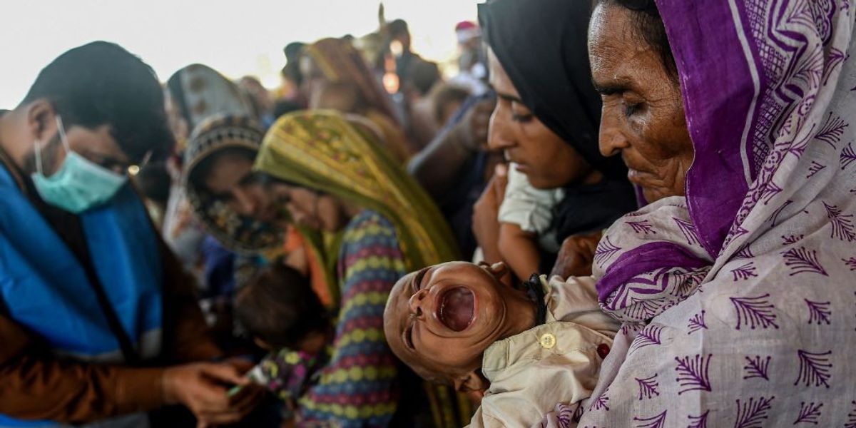
India and Pakistan remain on high alert this week as a powerful cyclone churns across the Arabian Sea toward their coastlines. Authorities in both countries have spent the week evacuating more than 80,000 people ahead of the storm’s expected landfall on Thursday.
Meteorologists expect cyclone Biparjoy to strike the southeastern coast of Pakistan and the western Indian state of Gujarat with wind speeds of around 111 mph, making it the most powerful storm to hit the region in years.
“God willing, we will be able to overcome this situation with the support of the people,” said Pakistan’s prime minister, Shehbaz Sharif, said Tuesday in a tweet.
Storms in this part of the world can be particularly devastating. A combination of densely populated, low-lying coastlines, powerful storm surges, and easily flooded river systems make communities in India, Pakistan, and Bangladesh highly vulnerable to extreme weather. Climate change is exacerbating these conditions, raising temperatures in the Indian Ocean and Arabian Sea and fueling fiercer and more frequent storms.
Pakistan is still recovering from a flood that submerged a third of the country last September, killing nearly 1,700 people and displacing 8 million others. At the U.N. climate conference in November, the country’s climate change minister described the devastation and pressed wealthy nations establish a fund for “loss and damages” — the financial losses borne by nations that are suffering the impacts of climate change but bear little responsibility for causing it (Pakistan has contributed to less than 1 percent of global greenhouse gas emissions).
“Loss and damage is not charity, it’s about climate justice,” Nabeel Munir, a Pakistani diplomat and negotiator, said during the summit in Egypt.
The agreement to set up such a fund is remembered as the most important achievement of the conference, but some critics have called the move largely symbolic because it does not guarantee adequate financing to low-income nations experiencing severe climate impacts. In January, Pakistan held a meeting in Geneva to raise money for its flood recovery efforts. A group of donors that included the World Bank, the European Union, and the Islamic Development Bank pledged a total of $9 billion.
Pakistani officials said they will use the money to implement the Resilient Recovery, Rehabilitation, and Reconstruction Framework, an ambitious climate resilience and adaptation plan that includes measures such as building resilient public infrastructure and distributing cash to low-income families still recovering from the flooding.
In an interview with the Thomas Reuters Foundation, Ahmad Rafay Alam, a Pakistani environmental lawyer, praised the plan but cautioned that it will only work with the cooperation of local officials. He also noted that the $9 billion pledged in Geneva falls woefully short of the $30 billion in estimated damages, a fact made all the more challenging by the ongoing economic crisis that has sent inflation soaring in the past year.
The storm expected to make landfall on Thursday risks exacerbating these conditions. Evacuations ahead of Cyclone Tauktae in the spring of 2021 prevented a catastrophic loss of life, but caused more than $2 billion in destruction. A comparable storm could put the country even further behind its climate resilience goals, and make the need for a loss and damages fund that much more acute.
Experts say recent extremes are being influenced by a hodgepodge of distinct factors. Climate change is involved, but natural variations in global weather, and an unfortunate dose of serendipity, are also at play.
“Global warming itself hasn’t suddenly accelerated this year,” Daniel Swain, a climate scientist at the University of California, Los Angeles, said in a live briefing on Monday. “Part of what’s going on is random bad luck.”
Last week, the U.S. National Atmospheric and Oceanic Administration announced that El Niño conditions — above average sea-surface temperatures that spur higher-than-usual warmth in many parts of the world — were officially present in the Pacific Ocean. The swing from La Niña, El Niño’s opposite extreme, to an El Niño means a much warmer year is in store for the entire globe. But the cycle, which is associated with extremes such as drought and severe storms, also has localized impacts. In eastern and southern Africa, the Horn of Africa, Latin America, the Caribbean, and parts of the Asia-Pacific region, El Niño can spur famine, outbreaks of infectious disease, and heat stress. The natural weather phenomenon may also be having an impact, Swain said, on record-breaking land surface temperatures in Canada that have helped to fuel its devastating fire season so far.
At the same time, scientists have been keeping tabs on a separate phenomenon unfolding in the Atlantic Ocean. Temperatures in the Atlantic hurricane region have been anomalously high for three months now. They are currently 82 degrees Fahrenheit on average — 35 percent higher than a prior record set in 2005.
“There has never been any day in observed history where the entire North Atlantic has been nearly as warm as it is right now,” Swain said. The rest of the Atlantic Basin — the Gulf of Mexico and the Eastern Seaboard — is also warmer than average, which means an active Atlantic hurricane season may be on tap. Generally, El Niño suppresses hurricane activity in the Atlantic and leads to a more severe typhoon season in the Pacific, but above-average Atlantic Ocean temperatures may negate El Niño’s dampening effects and fuel big Atlantic hurricanes this year.
A third factor, a volcanic eruption that occurred at the beginning of 2022 in the southern Pacific Ocean, is also contributing to above-average global temperatures. Volcanic eruptions typically have a temporary cooling effect on the planet because they shoot soot and other sun-blocking particles into the air. But the Hunga Tonga–Hunga Haʻapai eruption in the Tongan archipelago wasn’t a typical volcanic eruption. “This was a sub-oceanic, huge, massively explosive eruption that essentially vaporized huge quantities of sea water,” Swain said. The volcano’s plume was so intense that it shot vaporized water into the stratosphere, where the vapor has been having a warming effect on the planet.
All of this means we’re in for a period of accelerated warming due to the convergence of these factors. The good news is that the warming effect that El Niño and the Hunga Tonga eruption are having on the planet is temporary. El Niño lasts between nine and 12 months and the vaporized water in the stratosphere will fade in a few years.
The bad news is that climate change, which experts say contributed to the formation of this year’s El Niño and may be behind the record-breaking ocean temperatures in the North Atlantic, is still churning in the background. It isn’t going away anytime soon.
“The long-term trend is not going to stop,” Swain said. “We are stair-stepping up on our way to much warmer oceans and a much warmer climate.”
Climate change is remapping where humans can exist on the planet. As optimum conditions shift away from the equator and toward the poles, more than 600 million people have already been stranded outside of a crucial environmental niche that scientists say best supports life. By late this century, according to a study published last month in the journal Nature Sustainability, 3 to 6 billion people…
On Monday evening, meteorologists at the National Weather Service center in Upton, New York, noticed something unusual in the satellite imagery. A thick wall of smoke from a series of wildfires that had broken out across Nova Scotia was moving south toward the Empire State. After examining the wind patterns and speed of the plume’s movement, the meteorologists forecast it would enter the country’s most densely populated city by the following morning. Sure enough, New Yorkers awoke on Tuesday to gray air that thickened over the course of the day. By evening the city smelled like a bonfire. By the following afternoon, the air had turned orange.
When Stanford researchers crunched the numbers, they found that Wednesday, June 7 was the worst day of pollution from wildfire smoke in the nation’s history, in terms of the average American’s smoke exposure. Air quality plummeted across the Eastern United States, affecting cities from Charlotte to Philadelphia to Chicago. But in no city was the air worse than the Big Apple. The air quality index, or AQI, in parts of Brooklyn reached 484 — nearly double San Francisco’s highest hourly reading during California’s 2020 fire season. In a press conference on Wednesday afternoon, New York Governor Kathy Hochul called it “a health and environmental crisis,” and urged residents to take precautions. New York City Mayor Eric Adams said the situation was “alarming and concerning,” and told people to mask up and stay indoors.
But advocates and public health experts that Grist spoke to described officials’ efforts as slow and confused. Mask distribution efforts came well after the pollution had descended over the tri-state area. As global temperature rise fuels more powerful and frequent blazes across the continent, experts warn that even cities like New York that have not historically experienced wildfire smoke must step up their emergency preparedness efforts to keep vulnerable people safe.
“It’s been a lackluster, underwhelming, frankly problematic response by the City of New York,” said Lincoln Restler, a city council member who represents northern Brooklyn, in an interview. The city had received advance warnings about the impending pollution from state and federal authorities, he added, but “there was essentially no communication shy of a tweet for 36 hours into this crisis.”
Smoke from wildfires is a major public health risk since it contains fine particles that can lodge in lung tissue and other pollutants that can aggravate the respiratory system. Short-term exposure to this type of pollution has been linked to higher rates of asthma hospitalization and heart attacks. Like most public health threats, it doesn’t impact everyone equally. Older adults, pregnant people, and children are particularly vulnerable to exposure, especially if they live in areas that already experience a disproportionate amount of pollution.
In New York, that means places like the South Bronx, where a combination of highway traffic and heavy trucking near warehouses contributes to chronically unhealthy air. According to Columbia University’s Mailman School of Public Health, the neighborhood has one of the highest rates of asthma in the country, and Black and Latino patients account for more than 80 percent of asthma cases across the city.
“You have those chronic cumulative exposures for people who live in areas that are already more polluted, and then you’re stacking on now this intense shorter-term exposure to their long-term exposures,” said Jennifer Vanos, an associate professor in the School of Sustainability at Arizona State University who studies extreme heat and air pollution.
City officials know where the most vulnerable New Yorkers live and should have done more this week to protect them, said Eddie Bautista, the executive director of the New York City Environmental Justice Alliance, a nonprofit organization that works to advance environmental health in disadvantaged neighborhoods. He mentioned a program that his organization pushed the city to implement at the height of the COVID-19 pandemic, which distributed air conditioning units to low-income households so that they could stay cool and socially distant during heatwaves. He wondered aloud why local agencies did not take comparable measures this week, like quickly getting N95 masks to elderly people.
“Like a lot of other people, I’m just stunned at how slow the response was,” he said. “Now we’re bracing ourselves for who knows what upticks in ER visits over the next week.”
A growing body of research backs up his fears. In 2020, researchers at the University of British Columbia in Vancouver found that pollution from wildfires increased asthma-related calls for ambulances within one hour of exposure. A separate study from the California Department of Public Health noted increased incidents of cardiac arrest after wildfires in people 35 and older. Experts told Grist it will take weeks to understand whether hospitalization rates in the city increased as a result of the smoke exposure.
On Wednesday night, the city announced locations where New York City residents could pick up free N95 masks on Thursday. But some workers and advocates said the message came too late. Gustavo Ajche, a delivery bike worker and founder of Los Deliveristas Unidos, a collective of app delivery workers, told Grist that he did his rounds as usual on Tuesday, but by the end of the day he felt lightheaded and his throat hurt. On Wednesday, he was able to get through the day using an N95 mask.
“I think the city’s response lacked efficiency,” he told Grist in Spanish. “The smoke affected us since Tuesday, so since Tuesday there should have been a plan implemented to get more New Yorkers to mask up.”
Asked to respond to the critiques of the city’s response to the crisis, the mayor’s office referred Grist to a video of a Thursday morning press conference where Adams described the developing conditions and urged residents, once again, to don face masks.
“We clearly understand that these crises that we are facing around our health are something that we’re going to have to deal with,” he said. “Climate change is real and we must be prepared.”
Public health experts that Grist spoke to described actions that New York, and other cities, could take in the future to safeguard vulnerable residents from smoke-related health risks. They mentioned better-coordinated mask distribution, text alerts in advance of worsening conditions, and risk communication with business owners so that they can protect their staff. Officials could also implement programs to provide homeless people with emergency shelter and low-income and at-risk city dwellers with air purifiers and other materials that could improve their indoor air quality, since some people live in drafty old buildings that lack air filtration.
“Just because you’re indoors, you’re not necessarily safe from the impacts, because sometimes your indoor air quality is really, really poor,” said Mary Prunicki, director of the Sean N. Parker Center for Allergy and Asthma Research at Stanford University. In severe cases, “people who have the means may have already left the area, but that’s just not an option for a lot of people.”
Events like this week’s will likely become more common in cities that are unaccustomed to wildfire smoke as human-induced climate change increases the power and frequency of blazes across the world. Canada is currently experiencing what may be its worst wildfire season ever, with hundreds of forests burning across the country. Experts say that an effective emergency response plan is key to keeping people safe.
“You want to hear your local government officials, your local university officials, and your local hospital officials all putting out information,” Scott Sklar, a professor at George Washington University’s School of Engineering and Applied Science, told Grist. A city the size of New York has the capacity to prepare itself for a climate impact like this one. Nevertheless, he said, “we weren’t quite ready for it.”
Zoya Teirstein and Jake Bittle contributed reporting to this story.
Climate change has made Louisiana one of the most endangered states in the country. It has been struck by six major hurricanes in less than 25 years and lost hundreds of square miles of land to erosion in roughly the same period. But thanks partly to its extraordinarily bad luck — in particular the devastation of Hurricane Katrina in 2005 and the Deepwater Horizon oil spill in 2010 — the state has also secured an enormous amount of money for coastal adaptation: The federal government spent billions of dollars after Katrina to help Louisiana prepare for future storms, and a later settlement with BP over the Deepwater Horizon spill gave the state tens of billions more for coastal restoration.
This combination of bad luck and federal largesse has allowed Louisiana to pursue an audacious coastal protection program that has been touted as a “proven playbook” and “the right way to build climate resilience.” Officials have spent billions creating new marshes and diverting river sediment, slowing down the disappearance of coastal land, and they’ve also undertaken several large levee projects to protect low-lying populations. This plan has backing from both Democrat and Republican politicians, even though program officials talk openly about its role in responding to climate change. The latest version of the plan, which Governor John Bel Edwards called a “success story,” sailed through the legislature this week.
But a reality check is on the way. The state’s ambitious projects have successfully reduced land loss and flood risk, but many of its coastal communities still face an existential threat from climate change in spite of all the new infrastructure. And the money that has sustained the state’s coastal buildout will dwindle in the coming decade, forcing ever harder choices about what to fund.
Every six years, Louisiana’s Coastal Protection and Restoration Authority, or CPRA, releases a kind of shopping list, identifying which coastal projects it wants to fund over the following 50 years. According to the newest version of the plan, released this year, the state aims to spend a whopping $1 billion annually on those projects, an astonishing goal that reflects just how much federal funding the state has received. Half the spending goes toward ecosystem projects that are designed to slow down coastal land loss, and the other half goes toward projects that protect towns and cities from flooding.
But when it comes to slowing down land loss, CPRA has always been fighting a rearguard battle, said Simone Maloz, the campaign director for the Restore the Mississippi River Delta coalition and a key collaborator on the state’s plan.
“We can build thousands of acres of marsh really quickly by tapping into the river or tapping into dredged material from offshore sites,” Maloz told Grist. “But we cannot have it all the way that it used to be. There’s just not enough time, there’s not enough money, there’s not enough resources.”
Even with Louisiana’s unrivaled resources, coastal protection has become a matter of triage. CPRA’s own estimates show that the effect of its restoration program will be limited compared to the sheer scale of land loss. Under a moderate scenario, if the state sees just over a foot of sea-level rise in the next 50 years, CPRA’s coastal protection projects will save about a third of the 1,100 square miles that the state expects would vanish. Under higher projections, with two feet of sea-level rise over the same period, the projects would save less than 10 percent of a staggering 3,000 square miles of vulnerable land.
“We can rebuild a piece of marsh, but in 30 years, that may be the only piece of marsh there,” said Stuart Brown, a senior CPRA official and a main architect of the plan.
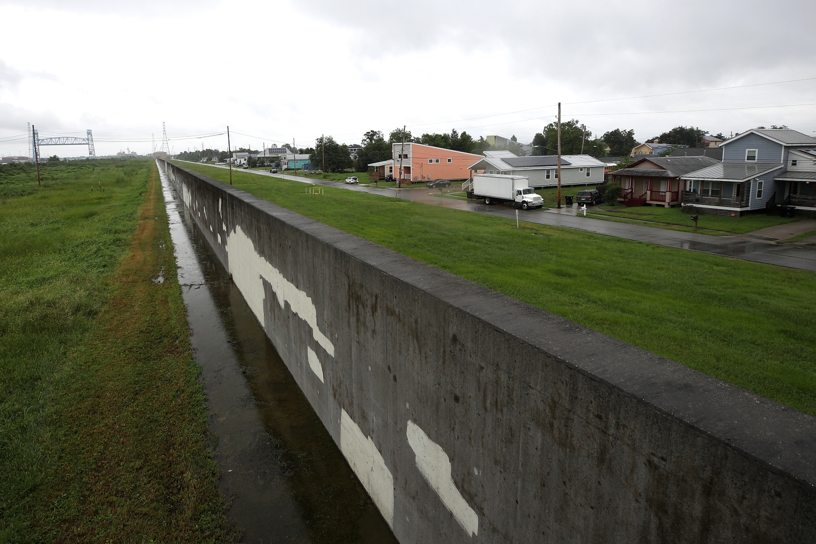
The state is also struggling to keep up with flood risk. For more than a century, Louisiana has relied on the federal U.S. Army Corps of Engineers to design and build large levee projects around major cities, with funds tending to arrive after these cities suffer damage from big storms. This was the approach the state took in New Orleans following Katrina: After the Corps’s old flood defense system failed during the storm, devastating the Lower Ninth Ward and nearby St. Bernard Parish, Congress gave the agency $14 billion to construct an enormous system of barriers and pumps. This system held up during a direct hit from Category 4 Hurricane Ida in 2021.
A rebuilt levee wall in the Lower Ninth Ward of New Orleans. Chris Graythen / Getty Images
In other places, work has been slower. A 98-mile levee network in swampy Terrebonne Parish has been in the works for more than 20 years, and other proposed projects have languished for years without funding. Even if these levees are finished, Louisiana’s coastline is so vulnerable to hurricanes that protected communities would still see several feet of flooding during the worst storms. Furthermore, many coastal areas are rural and under-resourced, which makes it difficult for the Corps to justify building levees, given the cost-benefit analysis the agency is required to perform for every project.
For these reasons, CPRA has started to carve out more money for what it calls “nonstructural” flood projects. These include elevating homes off the ground, retrofitting businesses to keep water out, and buying out residents in the most vulnerable homes. In its last coastal plan from 2017, CPRA set aside less than a quarter of flood protection money for these projects; in this year’s plan, they get almost half the state’s flood dollars.
“We identify the best investment to reduce risk, whether it’s structural or nonstructural,” Brown told Grist, adding that the state uses a planning algorithm for this purpose. “This money that we would spend on a levee — could that money be better spent on nonstructural projects anywhere on the coast?”
Thanks to money from the federal government and the BP settlement, Louisiana has never had to choose between elevations and buyouts, or between land restoration and flood protection. The state plans to spend $1.6 billion next year on adaptation projects, enough to fund new marshes and diversions as well as levees and home elevations. But these flush days won’t last forever. The Deepwater Horizon settlement and associated oil spill fees have provided the lion’s share of funding over the past two decades, and the last of the oil spill money will arrive in 2031, just eight years from now. When that money dries up, the state could have to constrain its spending by as much as 80 percent.
“There is that fiscal cliff that we will get to,” said Michelle Gonzales, the coastal management planner for Jefferson Parish, which includes a section of coastline south of New Orleans. “What is the fix there? Is there an appetite to tax ourselves to repair our coasts? I don’t know.”
Gonzales’s parish includes the fishing town of Lafitte, where CPRA has endorsed a large ring levee that will cost more than $1.4 billion to build. The agency says the project will begin in a decade or two, but there’s no way to know how much money the state will have at that point.
That financial calculus may push CPRA away from the projects that have been the hallmark of the state’s celebrated coastal program. Even if Louisiana does manage to secure more money to build levees, the operation and maintenance of those levees is the state’s own responsibility, which puts the state on the hook for billions more in lingering costs over the coming decades. And elevating homes isn’t a foolproof solution either, since raising them off the ground by more than 15 feet makes them more vulnerable to wind damage during big storms. And if the state falls further behind on marsh diversion projects, flood risk will only increase.
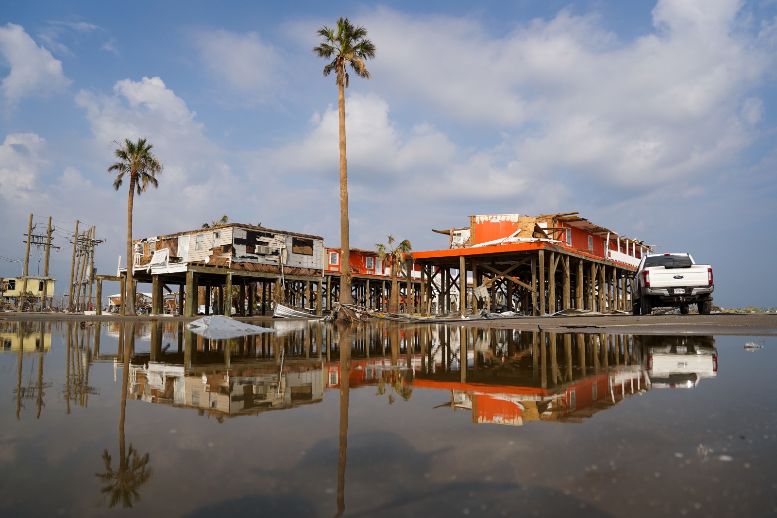
Storm-damaged houses are reflected in flood water after Hurricane Ida made landfall on Grand Isle, Louisiana. The 2021 storm destroyed thousands of homes and eroded sections of coastline. Sean Rayford / Getty Images
As funds disappear, the state’s only option may be to embrace what experts call “managed retreat,” a coordinated movement out of the riskiest areas. This is a reality that other states like North Carolina have already had to confront. Even though Louisiana’s coastal plan has saved hundreds of square miles of land and reduced flood damages for many communities, it has also served to delay the state’s own reckoning with that reality.
The trouble is that retreat is unpopular, said Jessica Simms, a researcher with the National Academies of Sciences who studies climate adaptation in Louisiana. That’s especially true in a state that has long been able to rely on the federal government to protect its vulnerable communities.
“It’s very politically risky to talk about, because you don’t want to tell people to move,” she said. “And then if you give money to people to elevate their houses, they are still very much at risk.” When it comes to big levee projects, by contrast, “you can take the photos of the people with their hard hats on and their golden shovels, starting a project, and that looks great.”
Louisiana has already seen political blowback over buyouts. When the Army Corps of Engineers endorsed mandatory buyouts and elevations for southwest Louisiana in 2015, the agency got hundreds of furious comments from residents who wanted levees instead. The agency revised its report to make the projects optional, but the broader problem was clear: Even with substantial money from Congress, there was no way to protect southwest Louisiana from storms except by moving people out of the way.
As the limits of the state’s coastal program begin to show, Simms told Grist that there’s another strategy that could serve as a better model. Instead of trying to leverage billions of dollars to slow down land loss and displacement, states could use federal money to ensure that the inevitable retreat can be easier. In 2016, after Louisiana won a grant from the Obama administration, it undertook a series of local adaptation projects based on grassroots input from hundreds of coastal residents. These projects included affordable housing for residents moving back from the water and a mental health program to help residents of eroding Plaquemines Parish cope with the loss of a familiar environment.
The LA SAFE program, as the grant-funded project was known, wasn’t as flashy as the levees and diversions that CPRA has endorsed, but Simms thinks it was a more sustainable framework. Rather than trying to hold onto a reality that was vanishing, the state was helping communities with the adaptation that was already happening.
“I think there is often such a disconnect between the brain of the bureaucrat in Baton Rouge and the folks who are living in these places,” Simms told Grist. “I think we can use coastal restoration to help people grieve what they’re losing, and also adapt.”
Youth activists and a tiny South Pacific nation have won a climate victory that could spell big trouble for the world’s leading polluting nations.
The United Nations passed a pioneering resolution Wednesday put forth by the nation of Vanuatu asking the world’s highest court to weigh in on the role national governments must play in stemming emissions and fighting climate change.
The advisory opinion, which might not come for two years, could impact thousands of lawsuits filed worldwide against governments for their inaction in addressing the crisis. It could even lead to penalties for the biggest polluters. Any opinion issued by the International Court of Justice would be non-binding but could shape pending litigation and influence the adoption of climate pacts that might follow the 2015 Paris Accords.
Vanuatu, a nation of more than 80 islands, spearheaded the campaign to pass the resolution because it is disproportionately impacted by climate change. People in Vanuatu faced twin cyclones this month alone.
“For us Pacific islanders, there is no place to hide from the climate crisis, no denying the reality we are facing,” Alatoi Ishmael Kalsakau Ma’aukoro, the nation’s prime minister, said in an op-ed in Time.
The push to pass the U.N. resolution came about from youth activists from throughout the Pacific Islands who were looking for concrete ways to tackle the crisis. They launched Pacific Islands Students Fighting Climate Change in 2019 with the singular goal of seeking an advisory opinion on the issue from the international court. It worked with the Republic of Vanuatu to put forth the resolution, which more than 120 member states have since signed on to.
“This resolution was adopted by consensus, which means the entire global community is standing together, asking the question of the International Court of Justice, because together is the only way that we will solve this problem,” Christopher Bartlett, head of climate diplomacy for Vanuatu, told Grist.
The effort to get the advisory opinion started in 2011, when representatives from the Marshall Islands and Palau attempted to pass a similar resolution — which the United States opposed. Michael Gerrard, founder of the Sabine Center for Climate Change Law at Columbia University, was involved in the 2011 effort and credits a political shift on climate for leading to this victory.
“The gravity of the climate crisis has become more apparent with the cascade of studies, and even more importantly, climate of weather catastrophes in different parts of the world. Additionally, one of the major reasons why the 2011 effort failed was the opposition of the United States,” Gerrard told Grist. “This was under the Obama administration and the United States actively opposed it–– this time they didn’t.”
Though the International Court of Justice is the most prominent court in the world, other international courts are also hearing cases related to climate change and human rights. The same day that the U.N. issued its resolution, the European Court of Humans Rights heard a case, brought by a group of elderly women in Switzerland, arguing that climate change is a human rights violation. Additionally, Chile and Colombia are making a similar claim and have requested an advisory opinion from the Inter-American Court of Human Rights. These concurrent cases could impact the ICJ’s ruling if either of them comes first.
The ICJ could take up to two years to issue its decision, and there is no indication where it will land, according to John Knox, a professor of law at Wake Forest University and the first United Nations Special Rapporteur on human rights and the environment.
“I think we can hope that it’s going to be a great decision, and one that really moves the ball forward,” Knox told Grist. “At the same time, the ICJ is a body of judges appointed by governments, many of whom are among the largest emitters of carbon gasses. I don’t think we should necessarily assume that the decision is going to be the strongest statement yet by any court that governments have obligations [to address climate change].”
Researchers at Northern Illinois University looked at data from the past 15 years, which compared different types of supercell storms. They concluded that these storms, which are precursors to tornadoes, will increase in frequency and intensity as the planet warms.
The scientists also concluded that tornadoes will shift eastward, from Tornado Alley in the Great Plains, where the storms have been the most active for decades.This comes after a series of lethal twisters made their way through Mississippi, leveling towns like Rolling Fork and Silver City, and severely affecting people in the capital city of Jackson.
The study showed an overall increase in supercell storms across the United States, but a greater increase in storms across the South, particularly around the mid-South region which encompasses Arkansas, Louisiana, Mississippi, Tennessee, Kentucky, Alabama and Missouri.
An association between tornadoes and climate change was previously difficult to establish, unlike the connection between climate change and hurricanes. Tornadoes are smaller and harder to measure than hurricanes, but the main impediment to linking tornadoes to climate change is that the latter weakens winds in the atmosphere while tornadoes require stronger winds.
The latest research, however, demonstrates that even with weaker winds, other factors resulting from climate change can make tornadoes more intense.
“That added ingredient of more heat and moisture is going to be the big thing that will influence what happens and we can expect potentially worse tornado outbreaks,” said William Gallus, a professor of meteorology at Iowa State University.
Gallus said that despite the fact that there could be fewer days of tornadoes, those days could feature stronger or multiple tornadoes.
Additionally, a geographic shift eastward could spell ongoing trouble for residents of the region, where housing stock is seen as less secure and the area is more densely populated.
“It’s not just the simple idea that the bullseye of most tornadoes is moving east,” said Gallus. “What’s bad is it’s moving into a part of the country where people tend to [be] more vulnerable to tornadoes. So the risk of injury and death is higher in those areas.”
When American settlers arrived in California 150 years ago, the sprawling Central Valley was home to the largest body of freshwater west of the Mississippi River. Tulare Lake expanded each spring as rain and melting snow filled the valley, growing so large that fisherfolk could sail across its surface to catch terrapin for San Francisco restaurants. But the land barons who took over the region soon drained the lake and covered it in crops, helping make it one of the nation’s most productive agricultural hubs.
Now, as California closes out a historically wet winter, Tulare Lake has reappeared for the first time since 1997. As runoff from several rivers drains into the valley, the homes and streets and fields that sit on the lake bed, which covers 1,000 square miles, are being inundated once again. The flooding will only increase over the next few months as the state’s record snowpack melts, dousing the area with the equivalent of 60 inches of rain.
Tulare Lake has always emerged during especially wet years, but the flooding will be worse this time: the region’s powerful agriculture industry has compounded flood risk around the lake by pumping enormous amounts of subterranean groundwater, turning the region into a giant bowl. Farmers overdraw the basin’s aquifer by around 820,000 acre-feet per year, far more water than Los Angeles consumes over the same period, and this pumping has caused the southern Central Valley to sink faster than almost any other place in the world.
Subsidence is occurring throughout California, but the problem is at its worst in the area around Tulare Lake, which is about 200 miles north of L.A. Some cities near the lake bed have sunk by as much as 11 feet over the past half-century. That rapid decline makes homes and crops in the basin much more vulnerable to flooding than when the lake last appeared 35 years ago. What’s more, the levees and channels that control flooding are getting less effective as the land around them subsides.
“Tulare Lake is playing Russian Roulette with flooding, and they just lost,” said Deirdre Des Jardins, an independent researcher and consultant who has studied flood risk in the Central Valley. “Water is flowing differently because of the subsidence, and they don’t have any kind of flood management.”
An 1873 map of California showing the former boundaries of Tulare Lake. Early American settlers drained the lake and planted crops on the dried lake bed.
David Rumsey Map Collection
Even as flood risk has grown due to subsidence, local leaders have rejected the state’s attempts to finance new flood defenses. When California began to draft a statewide flood protection plan after Hurricane Katrina, many counties and flood control districts in the agriculture-dominated Tulare Lake basin declined to participate, denying themselves state funding for new levees and bypass systems.
“The local interests who were there at those meetings were pretty adamant that they did not want to be part of a state level plan,” said Julie Rentner, president of the California-based environmental organization River Partners, who participated in the drafting of the plan. “They felt like they had it under control. Especially in some of the more conservative parts of California, there’s a real concern and real suspicion that the state intervening in the way water is managed will have deleterious impacts on local communities or local economy.”
In other cities, like Sacramento, the state spent billions to improve a network of levees and channels that helps manage runoff, but the Tulare Lake basin has no centralized flood infrastructure at all. Tulare County last updated its flood control master plan in 1972, when land in the area was several feet higher. The only levees in the lake bed are those owned and maintained by local flood control districts, which often lack the capital to make significant improvements. Those structure seem all but certain to fail as the lake reappears over the coming weeks, and some already have.
The officials charged with managing groundwater around Tulare Lake have also resisted the state’s attempts to control the pace of subsidence. Earlier this month, state officials chastised a group of local groundwater control agencies for failing to set “minimum thresholds and measurable objectives” for countering subsidence as required by state law. The agencies had said they wanted to limit the region’s subsidence to between 1 and 2 feet over 20 years, a number so high state officials thought it was a typo.
(Groundwater agencies and flood control districts that represent the Tulare Lake area didn’t immediately respond to interview requests.)
A flood map produced by Kings County, California, shows the former outline of Tulare Lake. The lake has emerged after a series of atmospheric rivers struck California.
Kings County Office of Emergency Management
Much of the land on the lake bed is owned by J.G. Boswell, an agricultural company founded by the famous land baron of the same name. Boswell is one of the titans of the Central Valley, and has long been among the largest private farming operations in the world — it grows cotton, tomatoes, wheat, and a variety of other staples on fertile land that used to be underwater. The company maintains pumps and flood cells to protect its crop from inundation, but many of its fields will likely flood later this spring.
But it’s not just farmland that stands to flood. The Tulare Lake basin is home to half a dozen small towns, including Allensworth, the oldest town in California founded by Black people, and Corcoran, which houses a large state prison and a large population of agricultural laborers. Due to the pace of subsidence, these towns grow more vulnerable to flooding with every passing year, and some have already taken on several feet of water this year. Earlier in March, someone sliced a hole in a barrier along a local creek, flooding most of Allensworth.
A vehicle surrounded by flood waters and flooded farmland near Allensworth, California. Much of the surrounding area has flooded as Tulare Lake reappears.
Patrick T. Fallon / AFP via Getty Images
Few people in these towns have flood insurance. Corcoran, one of the largest cities on the lake bed, has a population of around 22,000, but only five of its households participate in the National Flood Insurance Program. Furthermore, the Federal Emergency Management Agency hasn’t updated federal flood maps to account for the past decade of subsidence, so many residents in flood zones may not even be aware of the risk they face.
The worst is yet to come. Snowpack in the southern Sierra Nevada is almost triple the size of an average year’s, and warming weather will send the equivalent of 60 inches of rain toward Tulare Lake. That water will stick around for months or even years; as the lake grows, flooding could expand north toward the city of Fresno more than 40 miles away, putting thousands of homes and farms at risk. The lake bed also contains facilities like a sewage sludge composting plant that could leak or rupture as the area fills with water.
The result is a brutal irony. Draining Tulare Lake made it possible for the agricultural industry to thrive in the southern Central Valley, but that same industry has made the region more vulnerable than ever as the lake returns.
Terry Thies wasn’t worried about the rain that pounded on her roof last July.
She had received no flood warnings before going to sleep that night. Besides, her part of rural Perry County in Eastern Kentucky often gets heavy rain.
So early the next morning when her foot hit the water lapping the bottom of her wooden bed frame, Thies’ first thought was that the toilet had overflowed. But as she scanned her bedroom for the water’s source, she realized this was something else entirely.
“I came into the kitchen and opened the door and water was flowing down the lane,” Thies said. “Water was in my yard and rushing down. And I was like, well, I guess I’ve been flooded.”
Thies adjusts the post of the bed that belonged to her mother. It’s the same bed she woke up in to find that her home had flooded overnight last July.
Xandr Brown / Daily Yonder
In the days leading up to the storm, the National Weather Service predicted heavy rain and a moderate risk of flooding across a wide swath of eastern Kentucky and West Virginia. What happened instead was a record-breaking four-day flood event in eastern Kentucky that killed a confirmed 43 people and destroyed thousands of homes.
And though the National Weather Service issued repeated alerts, many people received no warning.
“Not a soul, not one emergency outlet texted me or alerted me via phone,” Thies said.
“Nobody woke me up.”
Thies’ experience in the July floods reveals troubling truths about Kentucky’s severe weather emergency alert systems. Imprecise weather forecasting and spotty emergency alerts due to limited cellular and internet access in rural Kentucky meant that Thies and many others were wholly unprepared for the historic flood.
Efforts to improve these systems are underway, but state officials say expansions to broadband infrastructure will take at least four years to be completed in Kentucky’s most rural counties. In a state where flooding is common, these improvements could be the difference between life and death for rural Kentuckians.
But there’s no guarantee they’ll come before the next climate change-fueled disaster.
Before the flood, Terry Thies’ home in Bulan, Kentucky, housed her family for two generations. It rests near a creek which flooded last July. Thies is still in transition and plans to sell her home to FEMA.
Xandr Brown / Daily Yonder
The first system that failed eastern Kentuckians in July was the weather forecasting system, which did not accurately predict the severity of the storm. A built-in urban bias in weather forecasting is partially to blame.
“Did we forecast [the storm] being that extreme? No, we didn’t,” said Pete Gogerian, a meteorologist at the National Weather Service station in Jackson, Kentucky, which serves the 13 eastern Kentucky counties affected by the July floods.
For the days preceding the storm, the Jackson station warned of a ‘moderate risk’ of flooding across much of their service area. Observers with the benefit of hindsight might argue that a designation of ‘high risk’ would have been more appropriate. But Jane Marie Wix, a meteorologist at the Jackson station, wrote in an email to the Daily Yonder that the high-risk label is rarely issued, and simply didn’t match what the model was predicting for the July storms.
Weather Prediction Center / NOAA
“When we have an event of this magnitude, we’ll go back and look at, are there any indicators? Did we miss something? Was there really any model predicting this kind of event?” Gogerian said. “But when you looked at [the flooding in] eastern Kentucky, it just wasn’t there.”
“I don’t think anyone could have predicted just how bad it was going to end up being,” Wix wrote.
Wix says the moderate risk warning was enough to warn people that the storm could have severe impacts in many locations. But the model’s inaccuracy demonstrates a flaw in the National Weather Service forecasting model system that was used at the time of the flood.
Extreme weather is hard to predict in any setting, but rural regions like eastern Kentucky are at an additional disadvantage due to an urban bias baked into national weather forecasting systems, according to Vijay Tallapragada, the senior scientist at the National Weather Service’s Environmental Modeling Center.
Forecasting models depend on observational data — information about past and present weather conditions —to predict what will come next. But there’s more data available for urban areas than for rural areas, according to Tallapragada.
“Urban areas are observed more than rural areas … and that can have some, I would say, unintended influence on how the models perceive a situation,” he said.
Although spaceborn satellites and remote sensing systems provide a steady supply of rural data, other methods of observation, like aircraft and weather balloons, are usually concentrated in more densely populated areas.
“Historically, many weather observations were developed around aviation, so a lot of weather radars are located at major airports in highly populated cities,” said Jerry Brotzge, Kentucky state climatologist and director of the Kentucky Climate Center. “That leaves a lot of rural areas with less data.”
Flooding in Kentucky reached treetops along Troublesome Creek in July 2022. Months later, household debris floated by floodwaters remained.
Xandr Brown / Daily Yonder
Weather prediction models are based on past events, so the lack of historical weather data in rural areas poses a serious challenge for future predictions, according to Brotzge. “For large areas of Appalachia, we just don’t know the climatology there as well as, say, Louisville or some of the major cities,” he said.
This lack of current and historical weather observation can leave rural areas vulnerable to poor weather forecasting, which can have catastrophic results in the case of extreme weather events.
A new forecasting model, however, could close the gap in rural severe weather prediction.
The new Unified Forecast System is being developed by the National Weather Service and a group of academic and community partners. The modeling system is set to launch in 2024, but the results so far are promising, according to Tallapragada.
“In the next couple years, we will see a revolutionary change in how we are going to predict short-range weather and the extremes associated with it,” he said.
The problem with the current system, said Tallapragada, is that it depends on one model to do all the work.
A new application called the Rapid Refresh Forecast System is set to replace that single model with an ensemble of 10 models. Using multiple models allows meteorologists to introduce more statistical uncertainty into their calculations, which produces a broader, and more accurate, range of results, according to Tallapragada. He said that although the new system is not yet finished, it has already proven to be on par with, or better than, the current model.
The Rapid Refresh Forecasting System will mitigate the disparity between urban and rural forecasting because it depends more on statistical probabilities and less on current and historical observational data, which is where the biggest gap in rural data currently lies, according to Tallapragada.
The system could also mean improved accuracy when it comes to predicting severe weather, like Kentucky’s July flood event.
“The range of solutions provided by the new system will capture the extremes much better, independent of whether you are observing better or poorly,” Tallapragada said. “That’s the future of all weather prediction.”
As extreme weather events become more common due to climate change, this advancement in weather forecasting has the potential to transform local and regional responses to severe weather. But without massive investments in broadband, life-saving severe weather alerts could remain out of reach for rural communities.
Over a year before the July 2022 floods devastated eastern Kentucky, some counties in the same region were hit by floods that, while not as deadly, still upended lives.
“There were no warnings for that flood,” said Tiffany Clair, an Owsley County resident, in a Daily Yonder interview. “It was fast.”
Clair received no warning when extreme rains hit her home in March of 2021, which severely damaged nearby towns like Booneville and Beattyville. “I did not think that those [towns] would recover,” Clair said.
Tiffany Clair’s family home in Owsley county was irreparably damaged last July. She managed to save herself, two kids, and mother — who has early onset dementia — by canoe.
Xandr Brown / Daily Yonder
Businesses and homes were impaired for months after the flood, affecting not only the people in those communities but those from neighboring communities as well.
“We live in a region where we travel from township to township for different things, and [the March 2021 floods] were a blow to the region and to the communities, because we’re kind of interlocked around here,” Clair said. “It’s part of being an eastern Kentuckian.”
A little over a year later, Clair faced more flooding, this time enough to displace her and her children. They now live with Clair’s mother.
This time around, Clair did receive an emergency warning, but questioned the method through which these warnings were sent. “[The warnings] did go all night, the last time, in July,” Clair said. “But if you don’t have a signal or if your phone’s dead, how are you getting those?”
During severe weather events, people are alerted of risk through a handful of ways. Weather information reported from regional National Weather Service offices is disseminated through local TV and radio stations, specialized weather radios, and the Federal Emergency Management Agency’s wireless emergency alert system, which requires cell service to deliver.
But in rural eastern Kentucky in July, the most common way people learned about the flooding was by seeing the water rise firsthand, according to a report from the Kentucky Department of Public Health.
The agency surveyed people from over 400 households in Breathitt, Clay, Floyd, Knott, Letcher, Owsley and Perry counties, as well as displaced residents living in three shelter sites. The goal of the study was to understand how the floods affected Kentuckians and determine ways to better prepare for the next emergency.
Nearly 14 percent of households in Letcher, Knott, Owsley and Perry counties and 28 percent of households in Breathitt, Clay, Floyd and Pike counties reported difficulty accessing internet, television, radio, and cell service for emergency communications during the floods. Cell phone service and internet access were the top two communication methods residents reported the most difficulty accessing.
The floods killed a confirmed 43 people: 19 from Knott County, 10 from Breathitt, seven from Perry, four from Letcher, two from Clay, and one from Pike County. Several more people died after the floods due to related health complications.
In Knott and Breathitt County, where death counts were the highest, approximately 32 percent of residents do not have broadband access, according to U.S. Census Bureau data. And in 10 of the 13 counties flooded in July, more than a quarter of residents lack broadband access.
Rural areas across the country are underserved when it comes to broadband, but eastern Kentucky is a special trouble spot, where high costs to serve rural customers have stopped internet companies from setting up broadband in rural areas. In 2017, Kentucky ranked 47th in the nation for broadband access, according to the Kentucky Communications Network Authority.
“There’s a lot of frustration because a lot of these internet service providers are profit-based companies,” said Meghan Sandfoss, executive director of the state’s newly created Office of Broadband Development. “So it’s hard for them sometimes to make a business case for the more remote and low density locations.”
The state’s effort to expand broadband has sputtered for years due to missteps by government officials, according to Propublica reporting. An internet connectivity project, KentuckyWired, was launched in 2013 with the goal to construct 3,000 miles of high-speed fiber optic cable in every Kentucky county by 2018. The project didn’t reach its final steps until fall of 2022, according to a KentuckyWired construction map.
Getting the cable laid down is only one part of the process: for individual households and businesses to actually access the internet, third-party providers need to connect their own fiber systems to the network, according to the Kentucky Communications Network Authority. This “last-mile” infrastructure is critical to broadband expansion, but progress has been slow.
“That might be another 10 years or 20 years while all that last-mile stuff gets built,” said Doug Dawson, a telecommunications consultant, in a ProPublica interview from 2020.
To speed up this process, both the state and federal governments have recently directed funds toward improved internet connectivity and last-mile infrastructure.
In June of 2022, Kentucky Governor Andy Beshear announced a $203 million investment in last-mile infrastructure funded through the American Rescue Plan Act. Another $20 million of grants was opened in September for broadband providers to replace utility poles that provide connectivity in underserved areas. And early this year, another $182 million in federal funding was awarded to fund Kentucky’s “Better Internet” grant program.
This grant program is focused on making it more commercially feasible for private internet providers to reach rural areas, said Sandfoss from the Office of Broadband Development. The priority is to build broadband infrastructure in unserved locations where there is no internet, versus under-served locations with limited internet access.
“A frustration we hear frequently is that all these new locations are being connected and everybody else has to wait,” Sandfoss said. “But that’s just the federal funding priority, and that’s the way we’ve got to do it.”
Construction on the state’s broadband infrastructure expansions is expected to occur over the next four years.
As extreme weather continues to batter rural Kentucky – floods in February killed one person in rural Marion County – some locals aren’t waiting for governmental changes to better protect themselves in the face of disaster.
Terry Thies, whose childhood home was flooded in July, has decided to sell her house.
“Now that it has flooded, it will probably flood again,” Thies said. She plans to move up the mountain, away from the creek that damaged her home. “I just don’t wanna go through it again.”
But for Kentuckians who don’t have the financial means to move away from higher-risk flood areas, they may be stuck in place. Eastern Kentucky is in the middle of a major housing crisis: affordable housing is sparse, buildable land outside flood zones is limited, and construction costs for new homes can be prohibitively expensive.
“[The flood] was horrible, but we were very, very lucky,” said Tiffany Clair, whose home was destroyed in the July flood. Clair and her children were able to move in with her mother when they lost housing. “But the next time I don’t think we’ll be that lucky.”
Clair believes that rural Kentucky’s ability to withstand the next natural disaster hinges on the actions taken by local and state leaders.
“We can’t do anything to prepare for it. It is going to take our leaders, it is going to take our politicians,” she said.
“They’re the ones that have to prepare for it because we can’t.”
Additional reporting by Caroline Carlson and Xandr Brown.
Droughts and floods are already intensifying as the world warms, putting solid observational data behind a trend scientists have long predicted and one that’s becoming increasingly visible to ordinary people.
Over the past 20 years, there’s been a sharp increase in both the wettest and driest weather events on the planet, according to a study published Monday in the journal Nature Water. The research relies on satellite data from NASA’s Gravity Recovery and Climate Experiment, used to measure subtle changes in Earth’s stores of water, including groundwater, surface water, snow, ice, and soil moisture.
It’s a sign of more extremes ahead, said Matthew Rodell, a co-author of the study and a hydrologist at NASA, with the data providing “strong evidence” that climate change is amplifying droughts and floods. “This has been something that’s very difficult to prove,” Rodell said.
The most intense floods and droughts on Earth began occurring more frequently in 2015, at a rate of about four per year instead of three, the study found. The ensuing years have been the eight hottest on record. Climate change was the largest driver of this shift in dry and wet events, outweighing the effects of the planet’s natural swings between hotter and cooler years caused by the El Niño and La Niña climate patterns.
Looking at more than 1,000 drought and flood events around the globe from 2002 to 2021, researchers analyzed their size, duration, and severity. Previous research tended to focus on averages, which are easier to measure than extremes, Rodell said. The new satellite data was able to capture slower-moving disasters that could last months or years.
According to the study, the most severe event of the last two decades was the extreme rain that hit sub-Saharan Africa beginning in 2020. Months of precipitation caused water levels at Lake Victoria to rise by about three feet and flood into the surrounding area. In terms of intensity, it was three times as large as the next biggest rain event: the floods that covered much of the Midwestern and Eastern United States starting in 2018.
The most severe drought took place in northeastern South America from 2015 to 2016, followed by the ongoing drought in the Cerrado region of Brazil.
So how is climate change making the world both drier and wetter at the same time? It comes down to the way that hotter air affects the weather. Warmer air can suck moisture out of the soil, amplifying droughts. On the flipside, warm air can also hold more moisture, meaning that it can transport more water into an already wet region.
Researchers had to exclude some areas from the study. In places like California’s Central Valley and Northern India, the fast rate of groundwater depletion messed with the data, making it hard to untangle drought from overzealous water usage. In Greenland and Antarctica, melting ice sheets posed similar problems.
The research did not analyze recent events, such as the flooding in Pakistan or the atmospheric rivers drenching California and causing widespread damage after years of extreme drought. Swings between these dry and wet extremes, sometimes called “weather whiplash,” is becoming common in some regions, another pattern that scientists have anticipated.
The increase in extreme flooding and drought could hold “dire consequences” for human health, crops, and regional unrest, according to the study. Understanding the kinds of intense weather events that lie ahead is “really important in order to build resiliency, prepare, and prevent future hardship and economic and agricultural damage,” Rodell said.
She will be called Aya. This is the name that nurses gave to the infant baby pulled from the rubble of a five-story building in Jinderis, northern Syria. A miracle. Beside her, the rescuers found her mother, dead. She had given birth within hours of the 7.8-magnitude earthquake that struck Turkey and Syria on the night of February 6, 2023. Like her, more than 50,000 people died in the earthquake. As tragic as it is hopeful, this story has moved the international media. It also reminds us that over 350,000 pregnant women who survived the earthquake now urgently need access to health care, according to the United Nations. And this is only one aspect of women’s vulnerability to natural disasters.
Floods, droughts, earthquakes, and other extreme events are not gender-neutral, especially in developing countries. Evidence shows that women and girls die in greater numbers and have different and uneven levels of resilience and capacity to recover. Of the 230,000 people killed in the 2004 Indian Ocean Tsunami, for example, 70% were women. Because of gender barriers, they often have fewer survival skills: boys are taught to swim or read first. This makes it difficult for them to access early warnings or identify safe shelters.
In addition, it is more difficult for women to escape from danger, since they are most often responsible for children, the elderly, and the sick. Heightened tensions and fear, as well as the loss of income provoked by disasters, drive increased domestic violence against women and girls. They are also the first victims of sexual violence and exploitation when entire populations are displaced—this was one of the first concerns in Pakistan when more than 8 million people had to leave their homes because of the terrible floods in June through August of 2022.
Progressive taxation—making the richest people and multinationals pay their fair share—is one of the most powerful tools for reducing inequality of all kinds.
Natural catastrophes negatively impact everyone economically, but women and girls are disproportionately affected. World Bank data show that female farmers suffer much more than male ones in rural areas. Assigned to domestic tasks, they are more dependent than men on access to natural resources and are, therefore, the first to suffer when these become scarce. In every region, food insecurity is higher among women than men. In 2020, it was estimated that nearly 60% of the people who go hungry are women and girls, and the gender gap has only increased since then. Their lack of access to bank accounts also means that women’s assets are less protected than men’s.
And, of course, recovery from any crisis builds on societal expectations related to gender roles. Consequently, women bear the brunt of the increased domestic burden after a disaster at the cost of missing out on other income-generating activities. We know that women spend, on average, 3.2 times more time than men on unpaid care work, and the COVID-19 pandemic—another human-induced natural catastrophe—made evident how unequally unpaid care and domestic work is shared, and how undervalued and underrecognized it is. This is a major constraint on women’s access to education, an obstacle to their entry into and advancement in the paid labor market, and to their political participation, with serious consequences in terms of social protection, income, and pensions.
Gender inequality exacerbates the impact of natural disasters, and the consequences of natural disasters exacerbate gender inequality. This is an unacceptable vicious cycle. With the world already facing a growing number of climate-related tragedies, governments must take immediate and long-term action to invest in universal access to health care, water and sanitation, education, social protection, and infrastructure for gender equality and the full enjoyment of women’s human rights.
As the world celebrates International Women’s Day, let’s keep in mind that it is impossible to build more resilient societies without fighting for gender equality.
Even in times of crisis, when state coffers are nearly empty, there are equitable solutions to raise revenues to fund the investments needed to strengthen women’s resilience: to make those who profit from the crises ravaging the planet, including from those natural disasters, pay, as recommended by the Independent Commission for the Reform of International Corporate Taxation (ICRICT), of which I am a member alongside, among others, Joseph Stiglitz, Jayati Ghosh, and Thomas Piketty. Instead of implementing austerity programs that devastate the most disadvantaged, states can increase their fiscal space by taxing companies and the super-rich more.
It starts with taxing the super profits made by multinationals, and several countries in Europe and Latin America have already begun to do so. This is particularly true for the pharmaceutical giants that have made a fortune selling vaccines against Covid-19, which they were able to develop due to public subsidies. This is also the case for multinationals in the energy or food sector: Oxfam estimates that their profits increased by more than two and a half times (256%) in 2022 compared with the 2018–2021 average. For the same reasons, it is urgent to tax the richest, who get away with paying hardly any taxes these days. One cannot accept that, as Oxfam reminds us, a man like Elon Musk, one of the wealthiest men in history, is taxed at 3.3%, while Aber Christine, a market trader in Uganda who sells rice, is taxed at 40%.
Progressive taxation—making the richest people and multinationals pay their fair share—is one of the most powerful tools for reducing inequality of all kinds. As the world celebrates International Women’s Day, let’s keep in mind that it is impossible to build more resilient societies without fighting for gender equality. Continuing to ignore it is a political choice, and an even more perilous threat to development than natural disasters themselves.
This post was originally published on Common Dreams.
A tornado has torn through New Zealand’s Bay of Plenty settlement of Waihi Beach ripping roofs off houses and cutting power to nearly 1500 properties as post-Cyclone Gabrielle extreme weather continued to impact on the North Island.
Footage shows the storm tearing through the area about 9am on Saturday.
MetService said a severe thunderstorm watch for the Bay of Plenty had been lifted just before 10am on Saturday, but there was potential for further stormy weather.
Meanwhile, more than 200 people spent the night sheltering in camps in Mangawhai in Northland on Friday night as several slips blocked exit routes, with the latest weather event still blowing through the North Island.
Overnight, Mangawhai residents who could not return home stayed over at schools in the Kaipara District.
MetService said the Mangawhai area received 300mm of rain over a seven-hour period.
Kaipara Civil Defence Controller John Burt said roads would be reassessed at first day light.
The majority of routes might remain closed due to major slips, including the main road between Kaiwaka and Mangawhai, he said.
Hawke’s Bay under heavy rain warning MetService has put a heavy rain warning in place for Hawke’s Bay until 1pm on Saturday and a severe thunderstorm watch is in place until 5pm on Saturday.
Hawke’s Bay could expect a further 70-120mm of rain about the ranges, and also away from the ranges north of Hastings (which includes the Esk Valley area and the Wairoa District), MetService said.
Hawke’s Bay Emergency Management Controller Ian Macdonald said his biggest fear was if more rain than forecast fell.
Macdonald said localised downpours were a problem when silt was still around, but he believed the region was in a good position to cope.
“Plenty of resources at the moment, obviously we’re now fully activated and have been for a week and a half, we’ve got lots of NZ Defence Force here, so you know we’re in a good space if we do need to evacuate people.”
Police said the number of people who remained uncontactable in Hawke’s Bay and Tairāwhiti following Cyclone Gabrielle was 13 at 9pm on Friday — that is down from 56 people on Thursday evening.
The residents of Esk Valley were evacuated on Friday ahead of the heavy rain and Macdonald urged all Hawke’s Bay residents to be prepared to evacuate if they needed to.
Hawke’s Bay Civil Defence said a full assessment of Esk Valley would take place today.
It said the rainfall overnight was less than forecast, but MetService expects more rain across the region on Saturday.
Te Karaka residents advised to evacuate Tairāwhiti Civil Defence Emergency Management on Saturday morning strongly recommended that people evacuate if they were in the Te Karaka township area.
The Waipaoa River at Te Karaka was expected to peak at 8 metres at 9am on Saturday.
A truck removes belongings discarded on the roadside in Te Karaka this week. The small town of 500, about half an hour from Gisborne, was particularly hard hit by Cyclone Gabrielle. Image: Rebecca Grunwell/Gisborne Herald/RNZ News
In Gisborne, Mayor Rehette Stolz urged locals to seek help if they needed it this weekend, with the latest deluge likely causing more slips and flooding.
More atrocious weather had held back cyclone clean-up efforts and dampened people’s spirits, she said.
It may mean more people would need support from council and Civil Defence, Stolz said.
“We might have missed people and we want to know if you need anything, so if you need to make contact with the Gisborne District Council Civil Defence please reach out, we are there to help you.”
Tolaga Bay warning
Uawa Civil Defence in Tolaga Bay have urged people to stay off the roads as the Hikuwai river is currently at 11.5 metres.
The Hikuwai has begun to drop as rain has stopped in the area. State Highway 35 is closed from Okitu to Uawa due to flooding at Rototahi, SH2 at Ormond is also closed.
Meanwhile, staff from the National Emergency Management Agency and council are still working out how to make a risky debris dam safer, so locals can return home.
Sixty-four homes were evacuated in Tokomaru Bay on Thursday due to fears a debris dam on the Mangahauini River would fail during more heavy rain.
Stoltz said the dam had held up so far, and staff were working at pace to come up with a solution.
This article is republished under a community partnership agreement with RNZ.
Current funding is not nearly enough to rebuild the thousands of homes damaged or destroyed in last July’s historic flooding in eastern Kentucky, according to a new research analysis.
The report, released earlier this week by the Ohio River Valley Institute and the Appalachian Citizens’ Law Center, estimates the cost of renovating or rebuilding the region’s affected households could range from roughly $500 million to nearly one billion dollars, depending on how many people are relocated to less flood-prone areas. About $159 million has been raised so far by federal, state, and philanthropic sources to support local residents, the researchers found in a separate investigation.
Last July, a series of storms brought heavy rainfall to eastern Kentucky over a five-day period, causing catastrophic flooding and landslides. More than 40 people lost their lives. Roughly 9,000 households were damaged or destroyed in 13 counties across the state, according to the report. Five hundred and forty two homes were categorized as destroyed, while more than 4,500 were severely damaged.
The report’s researchers used Federal Emergency Management Agency, or FEMA, data on income levels of households who applied for aid, as well as the results of home assessments the agency conducted, to create two potential aid proposals for the rebuilding effort.
The first, which the researchers estimated would cost around $450 million ($150,000 per home), would only replace homes with moderate to severe damage, or those that had been destroyed, in the same location. The second proposal would replace destroyed homes and relocate them to less flood-prone areas, mitigating future flood risk. It would also use part of the funding to repair the more than 4,000 homes with moderate damage with better structural foundations. While the estimated cost, more than $950 million ($185,000 per home), is far more expensive than the first option, it would likely bring longer term protection from the economic and environmental risks of extreme weather.
“I think it’s just as challenging to do the first approach in the long run,” Eric Dixon, a senior researcher at the Ohio River Valley Institute and co-author of the report, told Grist. “Many people could potentially have to rebuild multiple times, and when you factor in the loss of life, it’s pretty clear that option B is the better option.”
Appalachian Kentucky is a region deeply indented by its narrow valleys and mountain ridges. Huge swathes of this landscape have been carved up by large mining companies who have extracted coal and other minerals for generations. Kentucky’s coal mining towns largely exist in these valleys — or hollows — while extraction sites on the high ridges above sit increasingly abandoned. But because of the isolation, there is often only one way in and out of these towns. When heavy rainfall occurs, the resulting flooding and landslides can quickly cut off these communities from outside resources. In addition, poor soil retention and lack of tree coverage on the ridges — the result of mining — means that when heavy rain hits, the water has nowhere to go but down into valley communities below.
While flooding is Kentucky’s most common and costly natural disaster, few of the small towns affected by last summer’s flooding were equipped to deal with the economic disruption and structural damage it caused. The report states that 95 percent of homeowners of damaged homes across the 13 counties lacked federal flood insurance. FEMA flood insurance costs Kentucky households around $1,000 per year, a heavy burden for many families in the state’s eastern Appalachian portion, which ranks as one of the poorest regions in the U.S.
Of the households that reported damage to their homes after the flood, 60 percent earn annual incomes of less than $30,000, according to the report, which cited FEMA aid applicant data.
As the risks to life and property from extreme flooding in eastern Kentucky will likely increase in the coming years, Dixon believes that presenting residents with a choice of how to best protect their homes, regardless of their financial status, is the only way forward.
“We lost 44 lives,” said Dixon. “If we don’t want to lose 44 more people the next time it floods in Eastern Kentucky, we need to make sure that people have the resources to make a choice to relocate to higher ground and safer areas.”


 (@DrTELS)