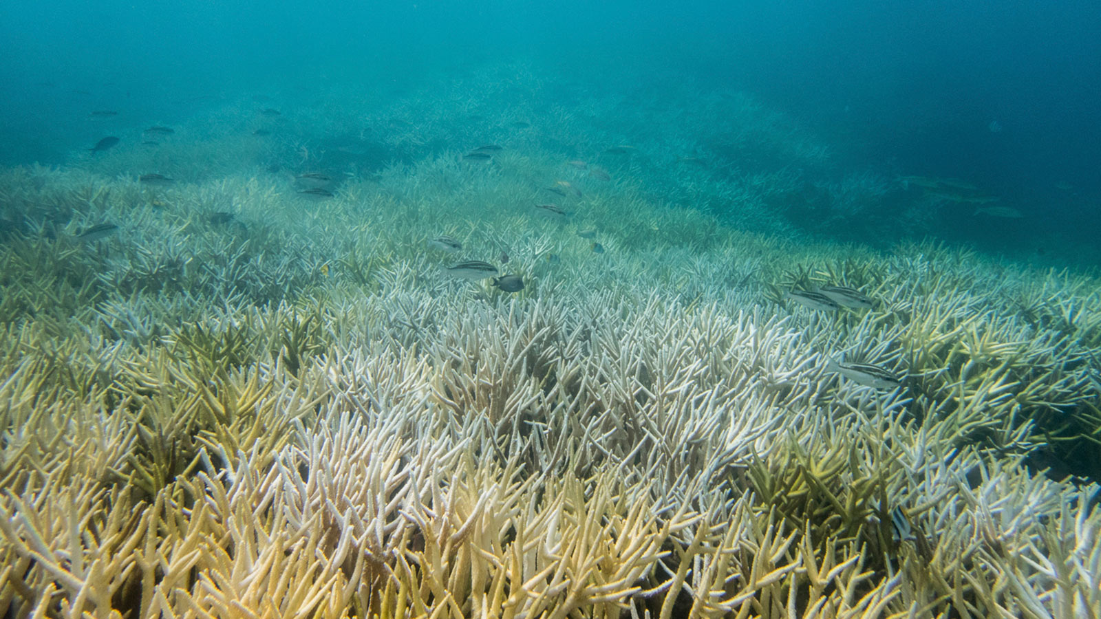
The Chinese military has announced a live-fire exercise in an area in the Gulf of Tonkin from Monday to Thursday this week, warning ships not to enter the zone.
The warning came as Vietnam issued a formal map defining the baseline to demarcate its territory in the gulf. Though neither side linked their action to that of the other, it was unlikely to be a coincidence, some observers said.
China’s exercise comes amid the latest wrangle between the neighbors over Vietnam’s island building in the Spratly archipelago in the South China Sea.
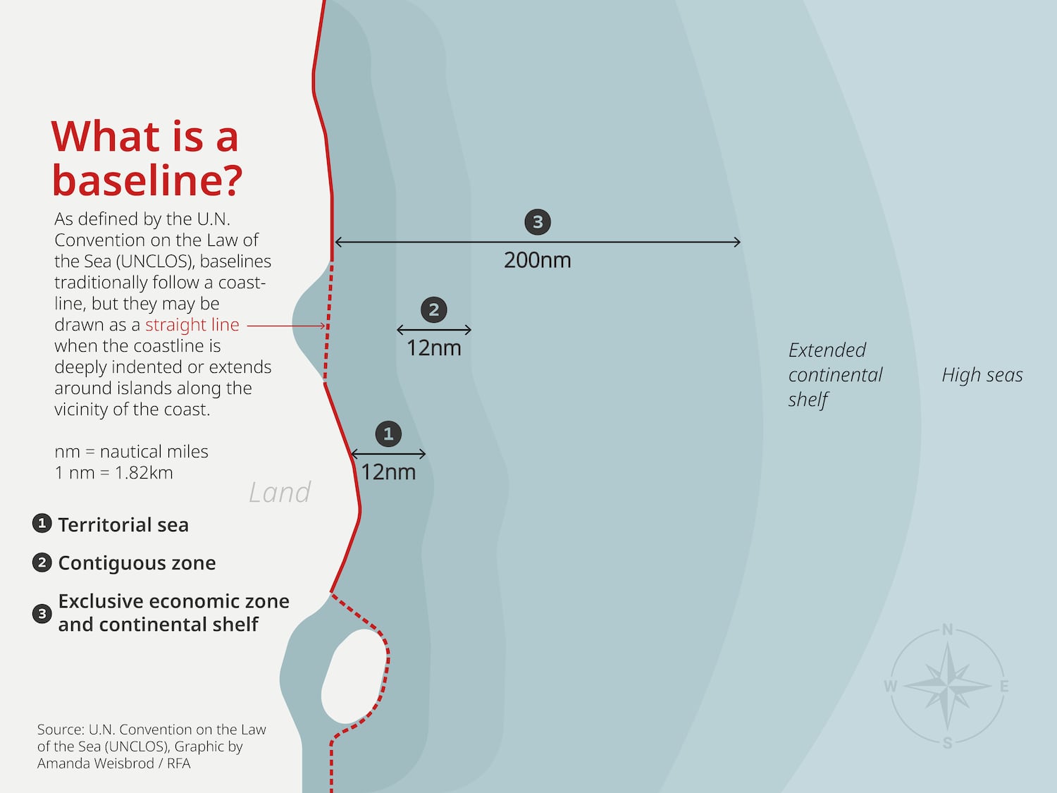
A baseline under the U.N. Convention on the Law of the Sea, or UNCLOS, is the line that runs along the coast of a country, from which the extent of the territorial sea and other maritime zones is measured.
In March 2024 China released its baseline in the northern part of the Gulf of Tonkin, deemed by analysts as “excessive.” Radio Free Asia was the first media outlet to report in April 2024 that Vietnam was considering its own baseline amid concern that China may seek to expand its maritime zones.
(RFA)
The Chinese baseline at some points encroaches about 50 nautical miles (93 kilometers) into international waters, according to analysts.
The U.S. military, which promotes freedom of navigation across the world, criticized China’s baseline, saying it may provide a pretext for China to “unlawfully impede navigational rights and freedoms guaranteed to all nations, including transit passage through the Hainan Strait.”
Chinese drills not ‘a pure coincidence’
“The establishment of the baseline in the Gulf of Tonkin aims to uphold Vietnam’s rights and obligations,” the Vietnamese foreign ministry said in a statement, “It provides a robust legal basis for safeguarding and exercising Vietnam’s sovereignty, sovereign rights and jurisdiction.”
China has yet to comment on its neighbor’s announcement but some Vietnam watchers said China’s live-fire drills appeared to be a response to Vietnam’s baseline.
“Although the exercise area off northwest Hainan island is relatively far from Vietnam’s waters, the timing seems too close to be a pure coincidence,” said Song Phan, a maritime researcher.
The new baseline that runs along Vietnam’s coast “conforms strictly to UNCLOS unlike the Chinese baseline,” he said.
Hanoi and Beijing in 2000 signed a Delimitation Agreement to demarcate their shares of the gulf from the mainland of Vietnam and China in the North to the mouth of the gulf in the South.
The two countries, however, have yet to renegotiate a joint fishery cooperation agreement in the Gulf of Tonkin after the old one expired in 2020.
Edited by Mike Firn.
This content originally appeared on Radio Free Asia and was authored by RFA Staff.
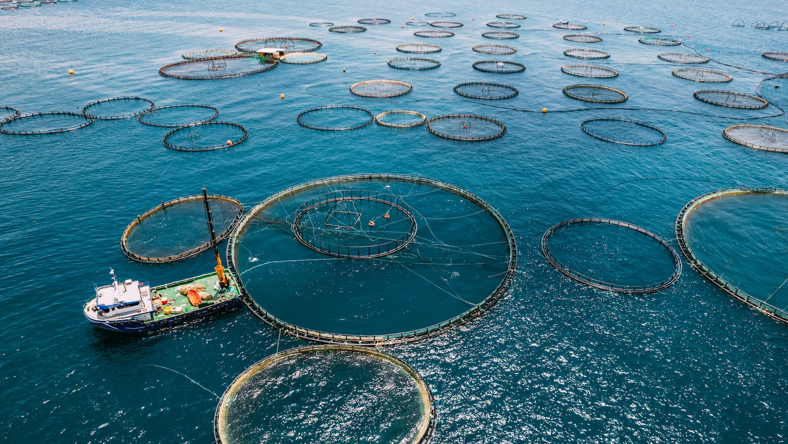
Floating cages with fish by the thousands may be popping in the Gulf of Mexico under a controversial plan that was backed by President-elect Donald Trump’s administration four years ago and is likely to gain traction again after Trump begins his second term next month.
The National Oceanic and Atmospheric Administration recently identified five areas in the Gulf that the agency says strike a balance between the needs of the growing aquaculture industry and the potential impacts on the marine environment and elements of the seafood industry that depend on wild fisheries.
Identifying these “aquaculture opportunity areas” is part of a decade-long federal plan to open the Gulf and other offshore areas to aquaculture. The plan got a strong push from Trump but slowed under President Joe Biden’s administration, which concludes next month.
Three of NOAA’s preferred aquaculture areas are off the coast of Texas and one is south of Louisiana. Each area ranges from 500 to 2,000 acres and could total 6,500 acres. A fifth area, considered a possible alternative, has been identified near the mouth of the Mississippi River, but it would likely conflict with shipping traffic and shrimping in that area.
The areas would open the Gulf for the first time to the large-scale cultivation of shellfish, finfish and seaweed. Seafood companies have long expressed interest in raising large, high-value species, including redfish and amberjack, in floating net pens several miles off the coasts of Louisiana, Texas and Florida.
The federal government is considering five locations for fish farms.
Opponents say fish poop, fish feed and other organic debris that often swirls around offshore aquaculture operations will worsen the Gulf’s massive “dead zone,” a New Jersey-size area of low oxygen that pushes away fish and suffocates slow-moving crabs and other shellfish. Fish that escape from floating farms can spread diseases and parasites, gobble up food that supports other species, and potentially mate with their wild counterparts, introducing their domesticated genes, which tend to produce slower, dumber fish.
“When you think of all of these environmental impacts, it’s pretty concerning,” said Marianne Cufone, executive director of the New Orleans-based Recirculating Farms Coalition, a group opposed to offshore aquaculture. “Plus, we get super violent storms in the Gulf of Mexico. I don’t know how these (farms) won’t be damaged with fish escaping.”
But the planet’s already-taxed wild fish stocks can’t meet the world’s expanding appetite for seafood alone, said Neil Anthony Sims, CEO of Ocean Era, an aquaculture company that hopes to develop a floating redfish farm 40 miles from Sarasota, Florida. His assertion is backed by a 2021 Stanford University study that predicted global fish consumption is likely to increase by 80 percent over the next 25 years.
“We can’t feed a planet with wild fish anymore than we could feed a planet with wild antelope,” Sims said.
Many fish, including tilapia and catfish, are raised in ponds and other land-based facilities. Floating fish farms in state-managed waters are increasingly rare. In 2022, Washington state effectively banned its once-thriving salmon farming industry after about 260,000 non-native Atlantic salmon escaped from a net pen north of Puget Sound. Hawaii still hosts a floating fish farm that raises Hawaiian kampachi, a fish related to amberjack.
Deeper waters managed by the federal government have remained aquaculture-free.
Like Trump, Biden backs opening federal waters to fish farming, but his administration has taken a more methodical approach, directing NOAA to study various areas that may be “environmentally, socially and economically viable” for supporting offshore aquaculture.
Trump was more forceful during his first term, signing an executive order in 2020 that was aimed at breaking through the regulatory barriers that have long impeded fish farming in federal waters. The Trump administration backed offshore aquaculture as a way to create jobs, broaden markets for U.S. companies and help meet growing demand for seafood.
A 2020 federal appeals court ruling blocked new regulations allowing offshore fish farming under the Magnuson-Stevens Act, the primary law governing fisheries since 1976. But other laws, including the National Aquaculture Act of 1980 and the Fish and Wildlife Coordination Act of 1980, give NOAA the authority to develop aquaculture opportunity areas and conduct environmental impact permitting for offshore farms.
The opportunity areas unveiled by NOAA last month set the stage for a final greenlight by Trump or Congress. The public can comment on the opportunity areas until Feb. 20. NOAA will host the first of three virtual meetings to gather feedback on the areas on Dec. 17.
NOAA is also considering aquaculture opportunity areas in Southern California, but opposition is likely to be stiffer there than in the Gulf, where residents are already accustomed to heavily industrialized coastal waters, with thousands of offshore oil and gas structures near Louisiana and Texas and pipelines crisscrossing the seafloor.
But adding more industrial infrastructure will further crowd the Gulf’s first industry: fishing.
“We’re already dealing with the rigs and oil wells and all kinds of debris,” said Acy Cooper, president of the Louisiana Shrimp Association. “And you want to put more out there? It’ll be our downfall.”
The Gulf’s shrimping industry has been losing ground to imported shrimp, which is typically raised in farms in Asia and South America and is far cheaper than the wild-caught varieties.
Cooper, a third-generation shrimper in Plaquemines Parish, said America’s desire for seafood should be met by fishers rather than farmers.
“If you want fish, there’s a lot of fishermen here for you. We ready,” he said.
But NOAA isn’t so sure the U.S.’s wild fisheries can support the demand for seafood alone. About 80% of the seafood consumed in the U.S. is imported, and about half of the imports are produced via foreign aquaculture. That’s giving rise to a “seafood trade deficit” that had grown to $17 billion in 2020, according to NOAA.
As much as U.S. fishers may want to meet demand, wild stocks are under increasing threat by climate change, which is altering marine species reproduction, feeding habits and distribution.
Offshore fish farming can help the U.S. adapt by producing seafood in a more controlled environment, according to NOAA.
“Aquaculture offers a pathway to grow climate resilience,” said Janet Coit, NOAA Fisheries’ assistant administrator. “Identifying areas suitable for sustainable aquaculture is a forward-looking step toward climate-smart food systems.”
But fish farms will likely worsen the dead zone, one of the Gulf’s main climate-related problems. The dead zone is fueled by agricultural runoff and other nutrient pollution that flushes into the Gulf from the Mississippi. Rising temperatures speed the growth of algae that feeds on the nutrients. When the massive algal blooms die, their decomposition robs the Gulf of oxygen.
Developing floating farms in and around the dead zone will add even more nutrients from poop and fish food that will nourish bigger blooms, Cufone said.
“We have warmer waters and all of the difficulties our fisheries are having because of climate change, but none of that supports an argument for factory fish farms,” she said. “If we care about climate change, we shouldn’t have them in our oceans.”
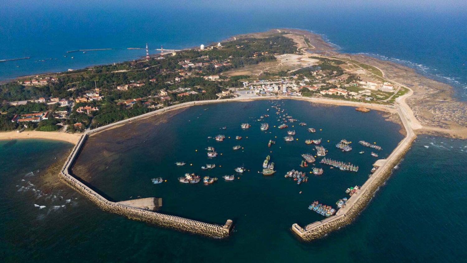
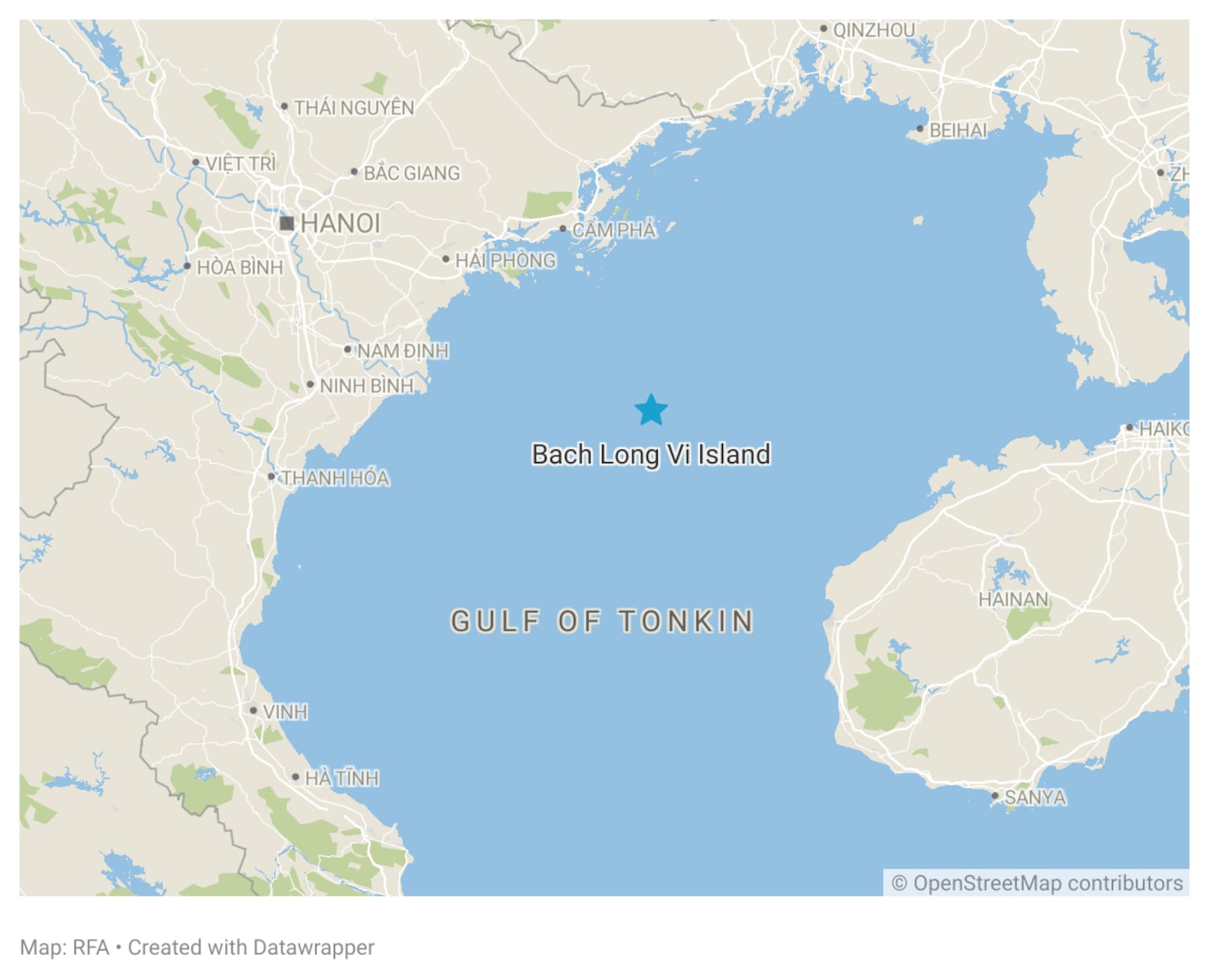
Vietnam’s top leader To Lam has made a widely publicized visit to an island north of the South China Sea, seen by an analyst as underscoring its strategic importance in the waters shared with China.
Lam became the first general secretary of the Vietnamese Communist Party to visit Bach Long Vi island in the Gulf of Tonkin since 2000, when Hanoi and Beijing finally signed an agreement to clearly demarcate their boundary there after nine years of negotiations
Last March, China unilaterally announced a new baseline that defines its territory in the northern part of the gulf called Beibu in Chinese, drawing concern from the Vietnamese government. Some analysts said that Beijing may use it as a pretext to push Hanoi to renegotiate the boundary agreement.
During the visit on Thursday, To Lam called on local government officials to develop Bach Long Vi island, “ensuring that it becomes a fortress for defending Vietnam’s maritime sovereignty,” according to media reports.
“The Party chief praised the island’s strategic importance, pointing out that Bach Long Vi serves as a key maritime gateway, controlling vital shipping lanes in the Gulf of Tonkin and providing logistics services for military activities at sea,” the Vietnam News Agency reported.
“General Secretary To Lam’s visit to Bach Long Vi was billed as a trip to learn about the living and working conditions of local residents,” said Carlyle Thayer, emeritus professor at the Australian Defence Force Academy in Canberra.
“However, the sub-text of his visit was to underscore the importance of the island’s infrastructure to national security and defense of Vietnam’s sovereignty over islands and sea.”
Bach Long Vi qualifies as an island under the 1982 United Nations Law of the Sea Convention
‘Normal practice’
“Media coverage highlighted that Bach Long Vi was located 15 nautical miles from the boundary line delimiting the Gulf of Tonkin,” noted Thayer. The distance means the island sits entirely inside Vietnam’s waters.
Bach Long Vi is Vietnam’s furthest island from its mainland and the largest habitable island in the South China Sea, with an area of more than 3 square kilometers (1.2 square miles). It is about 110 km (68 miles) from Haiphong in Vietnam and 120 km (75 miles) from China’s Hainan Island.
Bach Long Vi was transferred to Vietnam in March 1957 by a friendly China, which occupied it at the time, allowing Hanoi to establish a radar station there for early warning against U.S. air attacks.
Vietnamese historians said Beijing “returned” the island to the Democratic Republic of Vietnam, but some Chinese sources criticized the government of then-premier Zhou Enlai for “ceding” it.
In December 1992, it became an island district under the municipal government of Haiphong City.
“The Vietnam-China Maritime Boundary Delimitation Agreement for the Gulf of Tonkin signed in 2000 recognized that Bach Long Vi was a Vietnam’s island,” said Vu Thanh Ca, former director of the Vietnam Institute for Sea and Island Research, “There’s absolutely no dispute over its sovereignty.”
“Given the importance of Bach Long Vi as one of Vietnam’s frontier islands, Party chief To Lam’s visit is a normal practice,” he added.
Before the general secretary, Vietnam’s presidents Nguyen Minh Triet and Truong Tan Sang visited the island in 2010 and 2014 respectively, where they made strongly worded statements about “defending every inch of our country’s sea and islands.”
The year 2014 saw heightened tensions between Vietnam and China after the latter moved a deep-water oil drilling platform to near the Paracel archipelago that both countries claim. Beijing, however, did not officially react to the visits.
“China’s government does not and cannot dispute Vietnam’s sovereignty over it,” said Huy Duong, a Vietnamese South China Sea researcher. “But this does not stop some overly nationalistic Chinese regretting that China ‘gave away’ Bach Long Vi to Vietnam.”
Three former Memphis officers were convicted of witness tampering charges in the 2023 fatal beating of Tyre Nichols, while two were acquitted of federal civil rights violations in a death that sparked national protests and calls for widespread policing reforms.
Vietnam has expressed concern and demanded that China end “illegal” survey activities in Vietnam’s waters in the Gulf of Tonkin, a Vietnamese foreign ministry spokeswoman said.
A Chinese navy Type 636A hydrographic survey vessel, the Hai Yang 26, has been operating in Vietnam’s exclusive economic zone and continental shelf, said the spokeswoman, Pham Thu Hang, on Thursday without giving details.
Hang told reporters in Hanoi that the Vietnamese government “has engaged in multiple diplomatic exchanges” with the Chinese to demand the ending of the Hai Yang 26’s “illegal activities.”
Radio Free Asia is not able to verify whether the vessel is still inside Vietnam’s waters as it has not turned on its AIS (automatic identification system) for tracking.
In 2000, Vietnam and China signed an agreement on the demarcation of the Gulf of Tonkin, which is shared by both countries.
An exclusive economic zone gives a coastal country exclusive access to natural resources in the waters and seabed so the Chinese vessel’s activities are deemed unlawful, according to Vietnam’s foreign ministry.
“Vietnam also demands that China not repeat such illegal activities, fully respect Vietnam’s sovereign rights and jurisdiction, respect international law,” the spokeswoman said.
In March, China released a new “excessive” baseline for its claims of sovereignty in the Gulf of Tonkin, known in China as Beibu Gulf. Vietnam responded with a request that China “respect international law and bilateral agreements.”
Edited by Mike Firn.
This content originally appeared on Radio Free Asia and was authored by By RFA Staff.
Hanoi authorities are considering a baseline marking Vietnam’s territory in the Gulf of Tonkin, Radio Free Asia has learned.
In March, Beijing announced a new baseline demarcating China’s territorial sea – deemed by experts as “excessive” – in the northern part of the gulf. Chinese officials said the baseline was made “in accordance” with domestic and international laws.
Two Vietnamese government sources familiar with the matter told RFA that “relevant offices” in Hanoi are working on a new baseline for the Gulf of Tonkin, called Vinh Bac Bo in Vietnamese. They did not provide further details.
Before China’s announcement on March 1, 2024, neither country registered any baselines – used to measure the extent of the territorial sea and other maritime zones – in the gulf called Beibu in Chinese.
However, Hanoi and Beijing in 2000 signed a Delimitation Agreement to demarcate their shares of the gulf from the mainland of Vietnam and China in the North to the mouth of the gulf in the South.
China’s new baseline (red line) in the Gulf of Tonkin. (Google Maps/RFA)
China’s newly announced baseline is not thought to immediately affect Vietnam’s sovereignty in already clearly delineated waters but Hanoi is “definitely concerned by China’s unilateral action,” said Carlyle Thayer, emeritus professor at the Australian Defence Force Academy.
“It could result in Chinese pressure to amend the 2000 Delimitation Agreement on Tonkin to expand China’s maritime zone,” the security expert said.
Vietnam’s reaction
Vietnamese foreign ministry on March 14 released a statement calling on Beijing to “respect and abide by the agreement on the delimitation of the territorial seas, exclusive economic zones and continental shelves of the two countries in the Gulf of Tonkin signed in 2000, as well as the 1982 UNCLOS (U.N. Convention on the Law of the Sea).”
Beijing responded saying it was China’s “legitimate and lawful right” to determine the territorial sea baseline in the Gulf of Tonkin.
Experts say the new Chinese baseline on average encroaches 20 to 30 nautical miles (37 to 55.5 kilometers) upon international waters. It seriously impedes freedom of navigation through the Qiongzhou Strait, also known as the Hainan Strait.
“While the actual maritime delimitation line between the two countries is unchanged by this unilateral action, China’s new declared baselines bump out its internal waters well beyond what UNCLOS permits and do not bode well for future negotiations,” said Isaac Kardon, senior fellow at the Asia Program at the Carnegie Endowment for International Peace.
Vietnam and China are negotiating a new agreement on fishery cooperation in the Gulf of Tonkin after the previous one expired in 2019 and “China’s redesignation of the adjacent maritime areas will certainly complicate such an effort,” according to Kardon.
Vietnamese legal experts have called on Hanoi to define maritime zones for easier management of resources including fisheries.
“I am confident that the Vietnamese government will announce a new baseline for the Gulf of Tonkin and they will do it soon,” said Hoang Viet, a maritime legal analyst.
The United States which promotes freedom of navigation across the world has yet to say anything about the Chinese baseline.
Edited by Mike Firn.
This content originally appeared on Radio Free Asia and was authored by By RFA Staff.
Vietnam has requested that China respect international law and bilateral agreements with Hanoi after Beijing drew a new baseline in the Gulf of Tonkin.
The baseline is deemed as “excessive” by analysts, with one suggesting the U.S. should conduct a freedom of navigation operation to challenge it.
Radio Free Asia was the first Western media to report the announcement earlier this month of a new baseline that defines China’s territory in the northern part of the area known in China as the Beibu Gulf.
This baseline, which Beijing said was set in accordance with Chinese law, did not exist before.
Vietnamese foreign ministry spokesperson Pham Thu Hang on Thursday said that “all coastal countries need to abide by the 1982 U.N. Convention on the Law of the Sea (UNCLOS)” when drawing the territorial baseline, used to calculate the width of the territorial waters and other maritime zones.
She highlighted the necessity for these baselines to not affect the lawful rights and interests of other countries, including the freedom of navigation and the freedom of transit passage through straits used for international maritime activities.
The spokeswoman stopped short of rejecting the new Chinese baseline and instead called on Beijing to “respect and abide by the agreement on the delimitation of the territorial seas, exclusive economic zones and continental shelves of the two countries in the Gulf of Tonkin signed in 2000, as well as the 1982 UNCLOS.”
China’s new baseline (in red) in northern Gulf of Tonkin. (Google Maps/RFA)
Beijing has yet to respond to Hanoi’s statement but the Chinese foreign ministry’s Department of Boundary and Ocean Affairs said on its official WeChat account earlier that the announcement of the baseline was a necessary act to exercise national sovereignty and jurisdiction.
Encroachment on shared waters
The Gulf of Tonkin, or Vinh Bac Bo in Vietnamese, is highly important to both Vietnam and China not only in terms of economic development but also defense and security.
After nine years of negotiation, in 2000 Hanoi and Beijing signed a Maritime Boundary Delimitation Agreement to clearly demarcate each other’s territorial seas, exclusive economic zones and continental shelves in the Gulf of Tonkin.
Some analysts say the new baseline won’t affect Vietnam’s economic interests much as long as the signed agreement is observed but some are concerned that Beijing would use it as a pretext to push Hanoi to renegotiate the boundary agreement.
“China’s announcement of its baseline in the Gulf of Tonkin is a step up the ladder of escalation in its strategy of ratcheting up assertiveness in the South China Sea,” said Alexander Vuving, a professor at the Daniel K. Inouye Asia-Pacific Center for Security Studies in Hawaii.
“The new baseline puts Vietnam’s before a fait accompli,” he said, “It gives reasons for China to question the agreement that Beijing and Hanoi signed off in 2000 and push the boundary closer to the Vietnamese coast.”
UNCLOS stipulates that the drawing of straight baselines “must not depart to any appreciable extent from the general direction of the coast, and the sea areas lying within the lines must be sufficiently closely linked to the land domain to be subject to the regime of internal waters.”
The new Chinese baseline at some points encroaches about 50 nautical miles (93 kilometers) on international waters and on average, “it represents an encroachment of 20 to 30 nautical miles upon international waters,” according to Vuving.
“China’s baseline in the Tonkin Gulf is not in line with UNCLOS and can be rejected by an international court,” the security expert said.
Challenging China’s excessive claims
“China’s unilateral creeping excessive claims in other countries’ maritime and territorial domains even while a border resolution instrument is in existence, are becoming a regular event,” said Pooja Bhatt, an independent maritime security analyst.
Vietnam, as well as other countries in the same situation, should protest against this move, raise the issue at bilateral level and also bring international attention to it, she said.
“Keeping silence to save immediate Chinese backlash will harm countries’ future territorial integrity and national interests.”
The new expansive baseline would affect freedom of navigation activities in the area as no foreign vessels or aircraft are allowed to make so-called innocent passage through a country’s internal waters inside the baseline.
China also requires permission or notification before a foreign warship can sail through its territorial sea, measured 12 nautical miles outward from the baseline. Beijing has repeatedly protested against U.S. warships’ sailing in waters near the Paracel and Spratly archipelagos, which Washington insists is conducted in accordance with international law.
Vuving from the Daniel K. Inouye Asia-Pacific Center for Security suggested that several other countries may dispute China’s new baseline and the U.S. “may conduct a freedom of navigation operation to physically challenge China’s excessive claims.”
Edited by Mike Firn and Taejun Kang.
This content originally appeared on Radio Free Asia and was authored by Radio Free Asia.
 (RFA)
(RFA)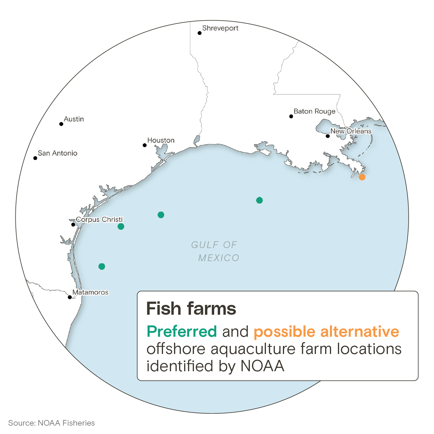
.png")


