In June 1942, Japan’s invasion of the Aleutian islands in Alaska prompted the U.S. military to activate the Alaska territorial guard, an Army reserve made up of volunteers who wanted to help protect the U.S. So many of the volunteers were from Alaska’s Indigenous peoples — Aleut, Inupiak, Yupik, Tlingit, and many others — that the guard was nicknamed the “Eskimo Scouts.”
When World War II ended and the reserve force ceased operations in 1947, the U.S. approached the Indigenous Yupik people of Alaska with another ask: Could the Air Force set up “listening posts” on the island of Sivuqaq, also known as St. Lawrence Island, to help with the intelligence gathering needed to win the Cold War?
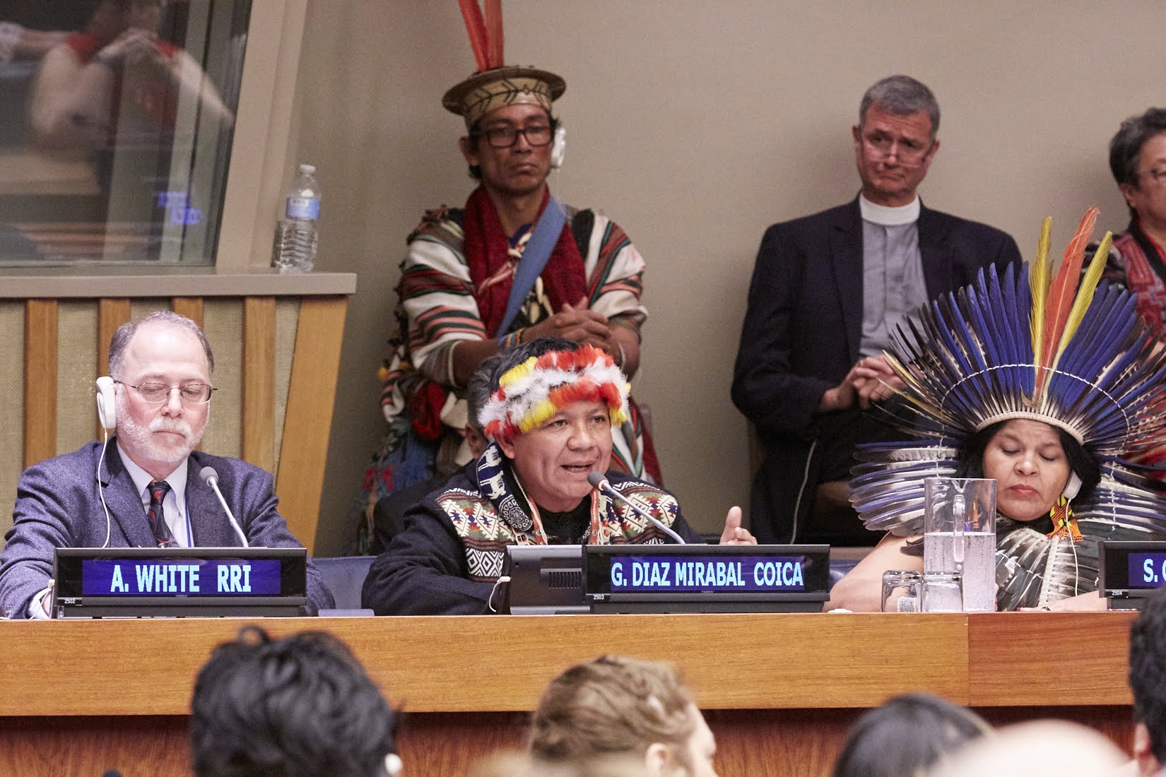
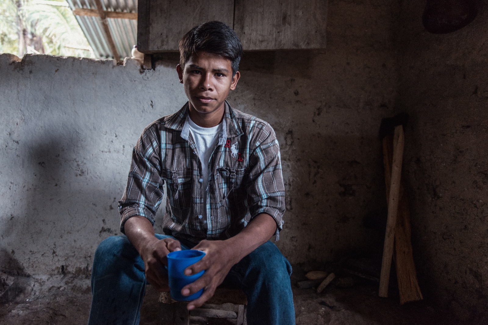
Viola Waghiyi, who is Yupik from Sivuqaq, said the answer was a resounding yes.
“Our grandfathers and fathers volunteered for the Alaska territorial guard,” she said. “We were very patriotic.”
But that trust was abused, Waghiyi said. The U.S. military eventually abandoned its Air Force and Army bases, leaving the land polluted with toxic chemicals such as fuel, mercury, and polychlorinated biphenyls, or PCBs, that are known as “forever chemicals” because they persist so long in the environment. The contamination was largely due to spilled and leaking fuel from storage tanks and pipes, both above ground and below ground. More chemical waste came from electrical transformers, abandoned metals and 55-gallon drums.
Now, Waghiyi is the environmental health and justice program director at the Alaska Community Action on Toxics, an organization dedicated to limiting the effects of toxic substances on Alaska’s residents and environment. Last week, the organization filed a complaint to the United Nations special rapporteur on toxics and human rights, in partnership with the U.C. Berkeley Environmental Law Clinic.
Their complaint calls for the United Nations to investigate how military waste on Sivuqaq continues to violate the rights of the people who live there, such as the right to a clean and healthy environment and Indigenous peoples’ right to free, prior, and informed consent to what happens on their land.
“By exposing the Yupik people of Sivuqaq to polluted drinking water sources, air, and soil, and by contaminating local native foods; by causing pervasive human exposure to hazardous chemicals through multiple routes; by toxifying the broader ecosystem; and by not cleaning up contamination sufficiently to protect human health and the environment, the U.S. Air Force and Army Corps of Engineers violated human rights long recognized in international law,” the complaint says.
This submission from Alaska is part of a larger, global effort to raise awareness of military toxic waste by the United Nations. The U.N. special rapporteur on toxics and human rights is collecting public input on military activities and toxic waste until April 1. The information collected will be used in a report presented to the U.N. General Assembly in October.
The two shuttered bases in Sivuqaq, Alaska, are now classified as “formerly used defense,” or FUD, sites, overseen by the U.S. Army Corps of Engineers, and more than $130 million has been spent to remove the contamination. John Budnick, a spokesman for the U.S. Army Corps of Engineers in Alaska, said the cleanup is considered complete but that the agency is reviewing the site every five years “to ensure the selected remedies continue to be protective of human health and the environment.”
“We have completed the work at Northeast Cape, but additional follow-up actions may result from the monitoring phase of the Formerly Used Defense Sites Program,” he said. The last site visit occurred last July and an updated review report is expected to be released this summer.
The federal Environmental Protection Agency, or EPA, similarly concluded in 2013 that an additional EPA cleanup wouldn’t significantly differ from what the Army Corps of Engineers is doing and declined to place the sites on the EPA’s list of hazardous waste cleanup priorities.
A 2022 study found that so far, federal cleanup efforts have been inadequate. “High levels of persistent organic pollutants and toxic metals continue to leach from the Northeast Cape FUD site despite large-scale remediation that occurred in the early 2000s,” the authors concluded.
The persisting pollution has garnered the attention of Alaska’s state Dept. of Environmental Conservation which oversees the cleanup of contaminated sites. Stephanie Buss, contaminated sites program manager at the agency, said her office has asked the U.S. Army Corps of Engineers to do additional cleanup at Northeast Cape.
“These active contaminated sites have not met closure requirements,” she said. The second former base, Gambell, was classified as completed but still lacks land use controls, she noted.
“DEC takes community health concerns seriously and will continue to provide oversight of the conditions at its active sites in accordance with the state’s regulatory framework to ensure an appropriate response that protects human health and welfare,” Buss said.
That same 2022 study found that 89 percent of the fish around the Northeast Cape base contained mercury exceeding the levels the EPA deemed appropriate for people who rely on subsistence fishing. “All fish sampled near the FUD site exceeded the EPA’s PCB guidelines for cancer risk for unrestricted human consumption,” the researchers further found. Waghiyi said the contamination displaced 130 people, and has left her friends and family with a lasting legacy of illness.
“It’s not a matter of if we’ll get cancer, but when,” Waghiyi said. Her father died of cancer. Her mother had a stillborn child. Waghiyi herself is a cancer survivor and has had three miscarriages.
“We feel that they have turned their back on us,” Waghiyi said of the U.S. military. “We wanted our lands to be turned back in the same condition when they turned over.”
The U.S. military has a long history of contaminating lands and waters through military training and battles sites, including on Indigenous lands. Citizens of the Navajo Nation in Arizona and Yakama Nation in Washington continue to raise concerns about the ongoing effects of military nuclear testing on their lands and health. In the Marshall Islands, fishing around certain atolls is discouraged due to high rates of toxicity due to nuclear testing and other military training. On Guam, chemicals from an active Air Force base have contaminated parts of the islandʻs sole-source aquifer that serves 70% of the population. Last year, a federal report found that climate change threatens to unearth even more U.S. military nuclear waste in both the Marshall Islands and Greenland.
In 2021, the Navy in Hawaiʻi poisoned 90,000 people when jet fuel leached from aging, massive underground storage tanks into the drinking water supply after the Navy ignored years of warning to upgrade the tanks or remove the fuel. The federal government spent hundreds of millions of dollars to remove unexploded ordnance from the island of Kahoʻolawe, a former bombing range in Hawaiʻi, but the island is still considered dangerous to walk on because of the risk of more ordnance unearthing due to extensive erosion.
The complaint filed last week by the Alaska Community Action on Toxics calls for the United Nations to write to U.S. federal and state agencies and call upon them to honor a 1951 agreement between the U.S. government and the Sivuqaq Yupik people that prohibited polluting the land.
The agreement said that the Sivuqaq Tribes would allow the Air Force to construct surveillance sites to spy on the Soviet Union, but they had four conditions, including allowing Indigenous peoples to continue to hunt, fish and trap where desired and preventing outsiders from killing their game. Finally, the agreement said that “any refuse or garbage will not be dumped in streams or near the beach within the proposed area.”
“The import of the agreement was clear: The military must not despoil the island; must protect the resources critical to Indigenous Yupik inhabitants’ sustenance; and must leave the island in the condition they found it, which ensured their health and well-being,” the Alaska Community Action on Toxics wrote in their complaint.
“This is a burden we didn’t create,” Waghiyi said.
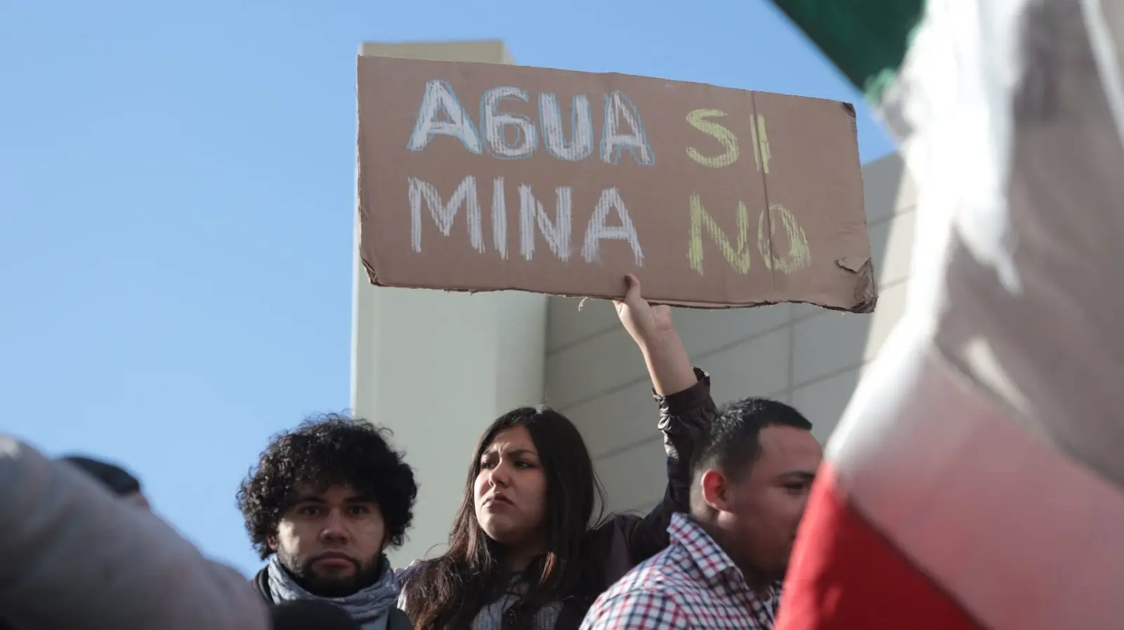
A Canadian mining company behind a massive new lithium mine in northern Nevada has received a $250 million investment to complete construction of the new mine — a project that aims to accelerate America’s shift from fossil fuel-powered cars but that has come under fierce criticism from neighboring tribal nations and watchdog groups for its proximity to a burial site.
Lithium Americas is developing the mine in an area known as Thacker Pass where it plans to unearth lithium carbonate that can be used to make batteries for electric vehicles. The area, known as Peehee Mu’huh in the Numu language of the Northern Paiute, is home to what could be the largest supply of lithium in the United States and is also a site that tribal citizens visit every year to honor dozens of Native men, women, and children who fled American soldiers in an 1865 unprovoked attack at dawn.
The funding from Orion Resources Partners LP, a global investment firm specializing in metals and materials, will enable the first phase of construction to be completed by late 2027. The investment firm is also considering giving an additional $500 million to support later phases of the mine’s development.
The critical financial investment comes just weeks after a report from the American Civil Liberties Union and Human Rights Watch called for a halt to the construction of the mine after concluding its approval violates the rights of Indigenous peoples whose ancestors are buried there.
“Orion’s commitment to this project highlights the strategic importance of Thacker Pass to national security and developing a domestic supply chain as we work to reduce American dependence on foreign suppliers for critical minerals,” said Jonathan Evans, Lithium Americas’ president and chief executive officer, in a press release.
Lithium Americas said that research indicates the actual burial site is located several miles away from the project site, and a federal judge agreed with the company, citing a cultural inventory study that did not uncover any human remains. Gary McKinney disagrees. He is a spokesperson for the group People of Red Mountain and is a descendant of one of the survivors of the September 12, 1865, massacre.
“What that mine is doing is desecrating,” McKinney said. “They’re erasing parts of the history of the Northern Paiute and Western Shoshone people.”
He said the mine was approved during the COVID-19 pandemic when reservations were shut down, Indigenous communities were grappling with high rates of the virus, and few realized the project was moving forward.
“Our tribal chairman at that time, he died of COVID,” said McKinney, who is an enrolled member of the Duck Valley Shoshone Paiute Tribe. “What I’m saying is this whole thing wasn’t done with the best of morals or intentions of honoring and respecting those cultural sites.”
His organization, People of Red Mountain, sued to stop the mine along with four tribes — Reno-Sparks Indian Colony, Burns Paiute Tribe, Summit Lake Paiute Tribe, and Winnemucca Indian Colony — but no court challenges have been successful. The Duck Valley Shoshone-Paiute Tribe also criticized the mine in an appeal to the United Nations special rapporteur on the rights of Indigenous peoples.
The American Civil Liberties Union and Human Rights Watch report from last month concluded the mine violates Indigenous peoples’ right to free, prior and informed consent to projects that affect their territories. The report notes tribes have raised concerns about the risk of toxic waste from the mine polluting their water and about their cultural practices being curtailed by limited access to the area.
In a letter to Human Rights Watch, Tim Crowley, vice president of government and external affairs at Lithium Americas, emphasized that the U.N. Declaration on the Rights of Indigenous Peoples, which contains the right to free, prior, and informed consent, is not binding. At the same time, the U.S. government believes consulting with tribes is sufficient without achieving support from all tribes, he said.
“Further, the Treaty of Ruby Valley, which is the treaty that pertains to Western Shoshone peoples in the Thacker Pass area, does not reserve rights to access off-reservation public land,” Crowley wrote. “The Thacker Pass Project is not in a federally recognized Native American territory. If it were, mining could not happen without the express consent and approval of that tribe.”
The new investment in Lithium Americas from Orion Resources Partners LP helps fulfill the terms of a $2.26 billion loan that Lithium Americas received last fall from the U.S. Department of Energy to support the project.
Abbey Koenning-Rutherford from the American Civil Liberties Union and Human Rights Watch said the Thacker Pass mine is symbolic of the broader risks of mining to Indigenous peoples and underscores why there’s a need to reform a 1872 U.S. mining law that enables companies to claim mineral rights on federal lands, including land stolen from tribal nations.
“The United States should respect Indigenous peoples’ centuries-long connections to Peehee Mu’huh and act to prevent further harm at Thacker Pass,” Koenning-Rutherford said.
Bribery, theft, conflicts of interest, and other forms of corruption are hampering global efforts to fight climate change and protect the environment. That’s according to a new study by Transparency International that reveals countries that experience high levels of corruption often bypass environmental laws to exploit natural resources, and rely on violence to silence resistance. That violence, one author explains, is often directed at Indigenous peoples.
“Coruption has always existed and probably always will exist unfortunately,” said Brice Böhmer, a researcher with Transparency International. “But at the same time, we have tools to stop corruption like proper consultation and oversight.”
Böhmer said the spillover to Indigenous peoples happens when governments adopt weak policies to address climate change, exposing communities to extreme weather events, first, and later, exploiting those communities through fraud, or political manipulation of policies and funds.
“This is impacting those groups more than other groups,” said Böhmer.
According to the report, countries that support democratic principles, like freedom of expression and assembly, are better protected from corruption. Access to information is important too. For instance, last year, the Dominican Republic’s score improved from previous reports after the country implemented data and collaboration practices to address corruption. Russia has also shown increased corruption as of late with the report showing that the invasion of Ukraine has deepened authoritarianism that suppresses “criticism of the government.”
Indigenous communities have long been stewards of biodiversity, defending vast territories from exploitation — despite that globally, only 35 percent of Indigenous lands are legally protected. Those without protection frequently fall victim to illegal logging, mining and animal trafficking, leading to frequent clashes between land defenders and settlers. In Indonesia, officials look the other way as the production of palm oil destroys Indigenous land. And in Brazil, corruption contributes to the fraudulent sale of protected Indigenous territories, leaving communities vulnerable to displacement and violence.
“You can think of corruption as a tax on everyone. So it’s an additional cost to the services provided by the government,” said Oguzhan Dincer, the director of the Institute for Corruption Studies at Illinois State University. He added that corruption is using public office for private gain and this affects anyone sending their kids to public schools, using public health care systems, or who wants clean air and water. “It takes a long, long time to get rid of corruption. It’s like a virus,” he said.
According to reports from Global Witness, environmental land defenders are at a high risk of intimidation and violence. Last year, nearly 200 people, half of whom were Indigenous or of Afrodescent, were killed for their environmental activism. Since 2012, an estimated 800 Indigenous people have been killed for protecting their lands and territories. According to Transparency International, most killings have occurred in countries who rank high in corruption.
But researchers also found that low levels of corruption did not always correspond with respect for Indigenous peoples. Finland, for instance, is one of the world’s least-corrupt countries according to Transparency International. However, in 2024, the United Nations Human Rights Council urged Finland to undertake justice measures that would address “the legacy of human rights violations endured by the Sámi people. That same year, the United Nations also recommended the country “initiate the process of legal recognition of the rights of Indigenous people to their traditional lands,” because they do not have the protected legal ability to make decisions regarding their homelands. Finnish officials did not respond to requests for comment on this story.
“People should demand anti-corruption policies and see the damage that corruption causes and be notified of the corrupt acts of the representatives,” Dincer said. “I’m portraying an awful picture here, but unfortunately this is really the case.”
This coverage is made possible through a partnership between Grist, BPR, a public radio station serving western North Carolina, WBEZ, a public radio station serving the Chicago metropolitan region, and Interlochen Public Radio in Northern Michigan.
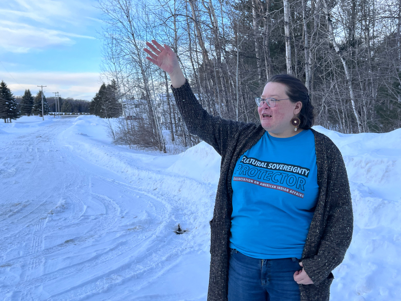
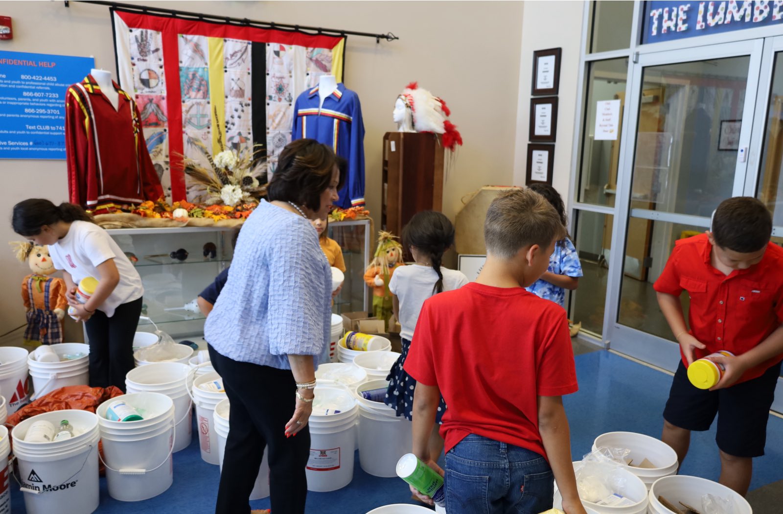
On a recent Friday afternoon, Marie Richards sat in her living room in northern Michigan. She was having a hard time talking about her job at the U.S. Forest Service in the past tense.
“I absolutely loved my job,” she said. “I didn’t want to go.”
Richards, a citizen of the Sault Ste. Marie Tribe of Chippewa Indians, was a tribal relations specialist at the Huron-Manistee National Forests. In mid-February, she found out she was one of the some 3,400 workers who had been targeted for layoffs — an estimated 10 percent of the workforce — as part of the Trump administration’s move to cut costs and shrink the federal government.
Richards watched as some of her colleagues were laid off on February 14 — the so-called Valentine’s Day massacre, when the Trump administration laid off thousands of probationary employees, generally hired within the past two years. She got a call from her supervisor that Saturday informing her that she had been let go, too. The letter she received cited performance issues, even though she, along with others in a similar position, had received a pay raise less than two months earlier.
“None of us deserved this,” Richards said. “We all work hard and we’re dedicated to taking care of the land.”
The U.S. Forest Service, which stewards 193 million acres of public lands from Alaska to Florida, was in trouble even before Trump took office. Chronically understaffed, the service was already under a Biden-era hiring freeze, all the while on the front lines of fighting and recovering from back-to-back climate disasters across the country.
Marie Richards loved her job as a tribal relations specialist for the U.S. National Forest Service. She was one of 3,400 workers targeted for layoffs.
Izzy Ross / Grist
For now, workers with the Forest Service fear this isn’t just the end of the line for their dream careers, but also a turning point for public lands and what they mean in the United States.
“It’s catastrophic,” said Anders Reynolds with the Southern Environmental Law Center, a nonprofit that litigates environmental issues in the southeastern U.S. “We are losing an entire generation of talent and passion.”
The federal agency does more than ensure that Americans have a place to hunt, hike, fish, or paddle. In the South, forest workers played a key role in helping western North Carolina and other communities recover from impacts of Hurricane Helene. In the West, they’re taking on fire risk mitigation and fighting wildfires. They’re also involved in fisheries management in places like Alaska. Across the country, agency biologists and foresters are busy working to strengthen the over 150 national forests and 20 grasslands it monitors in the face of changing climate.
Increasingly, the service is getting spread thin.
The agency has experienced a steady decrease in staffing over the last decade and the workers that remain are often overworked and underpaid, according to Reynolds.
“That means you’re going to see those campgrounds close, the trails go unmaintained, roads closed, you’re going to feel the effects of wildfire and hurricane recovery work that’s just going to remain undone,” said Reynolds. “Communities are going to struggle.”
The Forest Service has reduced its capacity over many years, causing headaches for staff.
A report from the National Association of Forest Service Retirees showed the agency losing a little over half of staff who supported specialty ecological restoration projects — meaning a whole range of jobs, from botanists to foresters to wildlife and fisheries biologists — between 1992 and 2018. As a result, understaffed Forest Service ranger districts, hemorrhaging staff positions, have consolidated.
Former employees report they saw serious financial and staffing shortages during their time. Bryan Box, a former timber sale administrator with the Forest Service who took some time out of the agency to care for his aging mother, said he found the working conditions unsuitable for a stable, normal life. Box worked for the Chequamegon-Nicolet National Forest in Wisconsin, where he said he made so little he biked around on his off days rather than wasting money on gas. While he was working, multiple national forests around him consolidated, causing a downward spiral on organizational capacity.
“We decommissioned buildings, we decommissioned the infrastructure that we had back in the ‘80s and ‘90s when we had this huge staff,” Box said. “And that put us into a position where we couldn’t hire seasonal employees anymore because we didn’t have housing for them. In rural northern Wisconsin, you know, just there’s not any housing available really. I think at one point our firefighters were all living above a bar.”
Other foresters he knew failed to make rent and were evicted or lived itinerantly, couch-surfing, for the love of the work they did. For Box, the financial realities became untenable. So, too, had the restrictions on his work, which grew as budgets failed to grow.
Box’s program was expensive to run and required travel, often to reduce fire fuels by harvesting timber after an emergency. The program he worked for, Box said, ended up needing to reduce costs by cutting travel funds and ending overtime, making it difficult for him to do his job well.
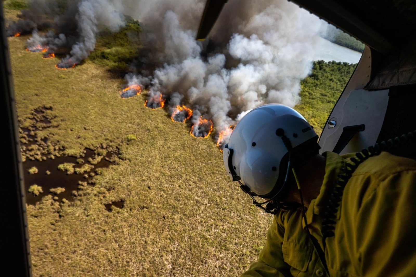
Much of their work involves emergency response, not only fighting fires but also picking up the pieces after conflagrations and hurricanes leave potentially thousands of acres of dead timber.
Matthew Brossard works as the current business representative and organizer for the National Federation of Federal Employees, and was formerly the general vice president for the National Federation of Federal Employees’ Forest Service Council, which represents around 18,000 employees of the Forest Service, 6,000 of whom are probationary, meaning they have either recently been hired or moved to a new position within the agency. Typically, probation — a part of every federal hiring process — is one or two years. Probationary employees were primarily targeted in the layoffs, meaning a generation of hires is potentially interrupted. Brossard said even though the administration maintains they have not fired positions essential to public safety, there’s more to fighting fires than just the firefighters. Support and logistical personnel are essential. “Extra dispatchers, security to close off roads, food unit leaders, base camp managers, all these very important, 100 percent-needed positions. Those people are getting terminated right now,” Brossard said.
In another instance recounted by Brossard, someone on assignment to help with long-term hurricane recovery in Louisiana was fired while he was there. The employee lived in Oregon and reported having no financial support for his trip home.
The loss of a seasonal workforce will also be felt, Brossard added. “Without that influx of seasonal workforce, it puts a huge amount of work onto the permanent staff if they’re still employed to do all the work,” he said, meaning not only trailwork and campground maintenance, but also research and other essential work. “So the work that in the summer that should have been done by 15 or 20 people are now going to be done by five or six.”
As workers continue to struggle with the fallout of their abrupt firings, their union is jumping in to protect them, Brossard said. The NFFE-FSC has joined in multiple lawsuits to challenge the firings, including one filed February 12, provided to Grist, that aims to put a stop to the firings and reverse the ones that have already happened, on grounds that the terminations are unlawful. A decision on the lawsuit is still to come, with more potential legal action following, Brossard said.
“You’re not reducing, you know, the stereotypical bureaucrats,” Brossard said. “You’re reducing the boots on the ground that are going out and doing work.”
In an emailed statement to Grist, a spokesperson with the U.S. Department of Agriculture said the new agricultural secretary, Brooke Rollins, supported Trump’s directive to cut spending and inefficiencies while strengthening the department’s services. “As part of this effort, USDA has made the difficult decision to release about 2,000 probationary, non-firefighting employees from the Forest Service. To be clear, none of these individuals were operational firefighters.”
The statement continued, “Released employees were probationary in status, many of whom were compensated by temporary IRA funding. It’s unfortunate that the Biden administration hired thousands of people with no plan in place to pay them long term. Secretary Rollins is committed to preserving essential safety positions and will ensure that critical services remain uninterrupted.”
Back in northern Michigan, Marie Richards, the former tribal relations specialist, crunched down the snowy driveway, pointing toward the Huron-Manistee National Forests where she worked. It spans nearly 1 million acres and covers land tribal nations ceded in two treaties, which the federal government has a responsibility to keep in trust.
Richards said workers like her are also a vital part of pushing the federal government to meet its trust responsibility to tribal nations. She helped connect the region’s federally recognized tribes with officials and staff at the forest service, set up meetings, and ensured work was being carried out responsibly.
“It’s not just the damage to that trust relationship with the Forest Service,” said Richards, who left her job as a repatriation and historic preservation specialist for the Sault Ste. Marie Tribe of Chippewa Indians to work at the agency. “It’s across the board for so many things, and tribes trying to work through that freeze, and making people understand that this isn’t DEI — that this is governmental affairs.”
Richards doesn’t know what’s next; she wants to finish her dissertation (about the impact of the lumber industry on traditional cultural landscapes and Anishinaabe bands and communities) and continue her work.
“It still really hurts that this dream of mine is kind of shattered, and we’ll see, and find a new dream,” she said. “But ultimately, my career, my livelihood, is in tribal relations for our heritage and I will find a home somewhere.”
Steven Amos feels hopeful for once. He’s finishing a drug and alcohol treatment program, living in a halfway house, and working a new job, doing carpentry. “I love anything outdoors,” he said. “I’m happy I’m not locked up.”
A member of the Northern Arapaho Tribe, Amos, age 53, grew up with the snow-capped Rocky Mountains set like a painting behind his childhood home in Ethete, Wyoming, on the Wind River reservation. He loved hunting and fishing along the Little Wind River, but his family — as well as many Wind River neighbors — had no running water, sometimes no electricity, or enough to eat.
The reservation’s stunning landscape conceals more than a century of theft and neglect by the United States, whose officials stole Arapaho land, then doled it out to ranchers, real estate moguls, miners, and public institutions, while forcing the tribal nation to scrape together a future any way it could.
One of Amos’s most searing childhood memories is watching police beat up his father. “They call it generational trauma,” he said, “It keeps going and going and going, and people don’t want to confront that. They want to sweep it under the rug.” He received his first prison sentence when he was 19 years old, and drifted in and out of jails and prisons for decades after that.
Some of the carceral facilities where Amos was sent are paid for, in part, with Arapaho land and resources, through activities like oil and gas extraction and cattle grazing.
To build America, the U.S. government enacted laws to redistribute Indigenous lands they had taken. Some land was given to individuals and corporations to build homes or private empires, through laws like the Homestead Act and the Pacific Railway Act, while the Morrill Act offered up freshly seized land as capital for states to establish what became known as land grant universities.
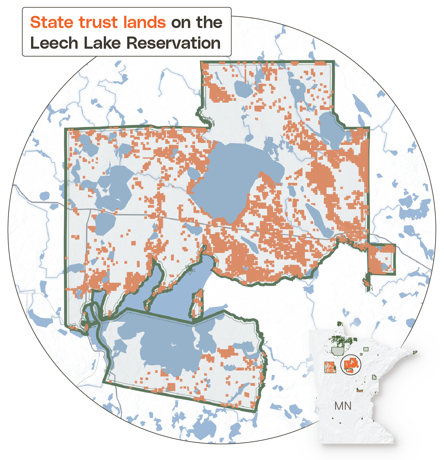
Separately, the legislation that transformed frontier territories into states — known as Enabling Acts — contained handouts of land that state governments could use to pay for public institutions. Those offerings are generally called state trust lands and continue to be used to fund public institutions, mostly K-12 schools, but also universities, hospitals, and penitentiaries.
Last year, in Wyoming alone, nearly 409,000 acres of former and current Arapaho, Shoshone, Goshute, Bannock, Crow, Cheyenne, and Sioux land now held by the state as state trust lands, produced at least $8 million in revenue for the Department of Corrections. At least 200 acres of land inside the boundaries of the Wind River Reservation are also earmarked to provide revenue for corrections.
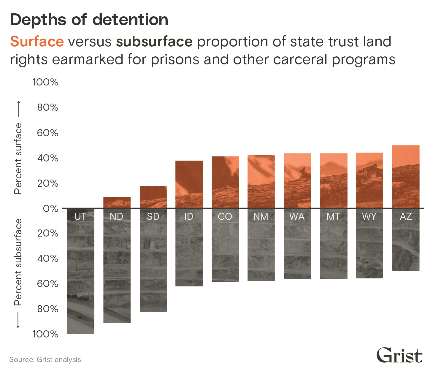
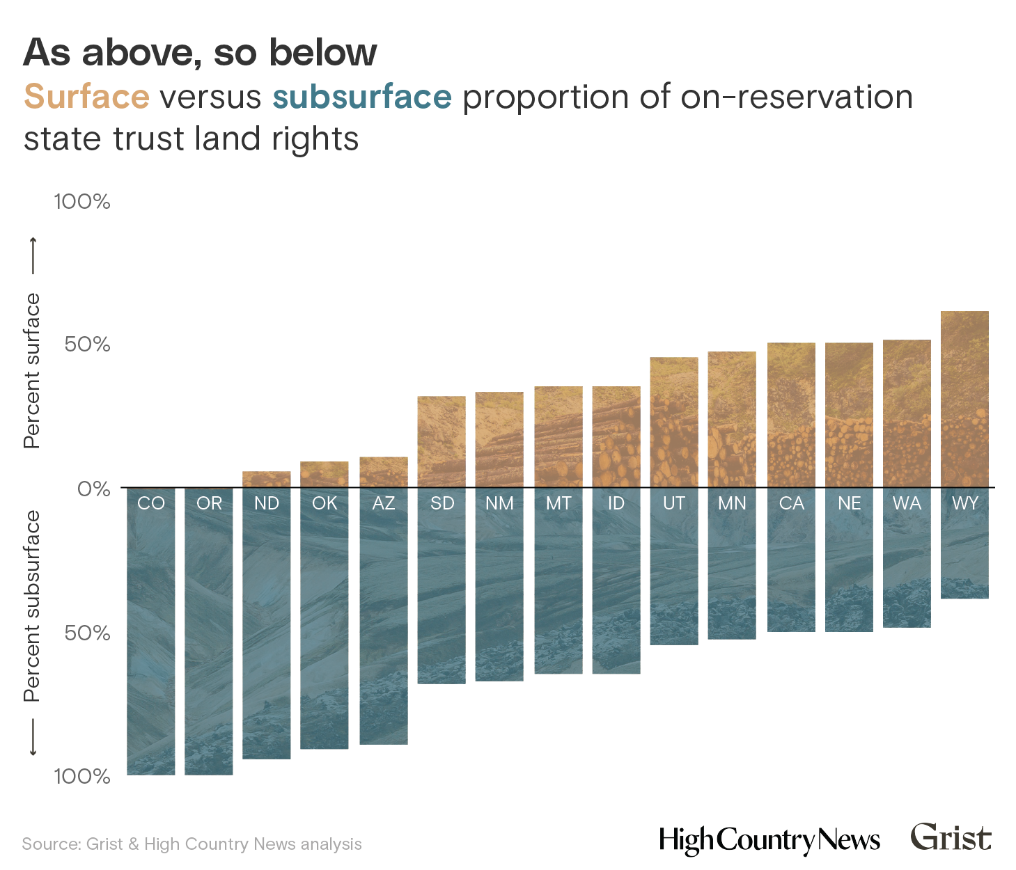
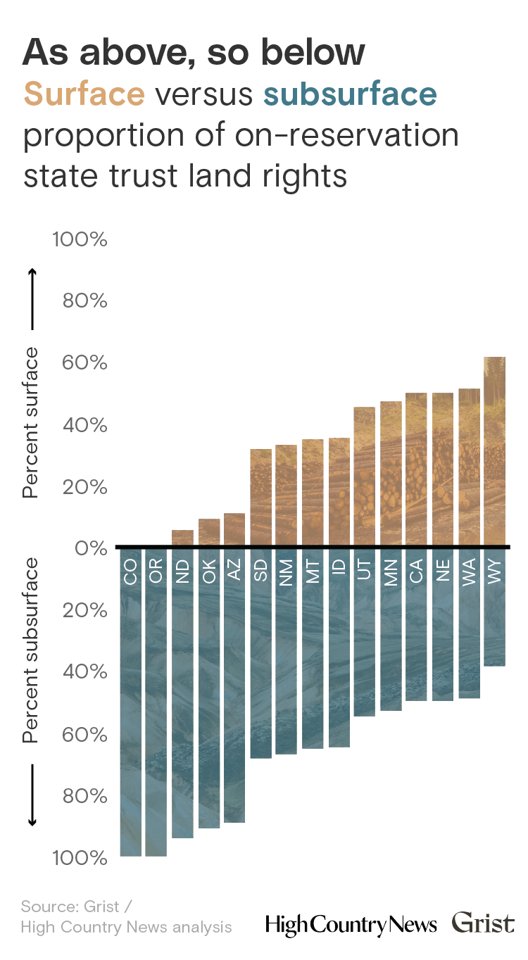
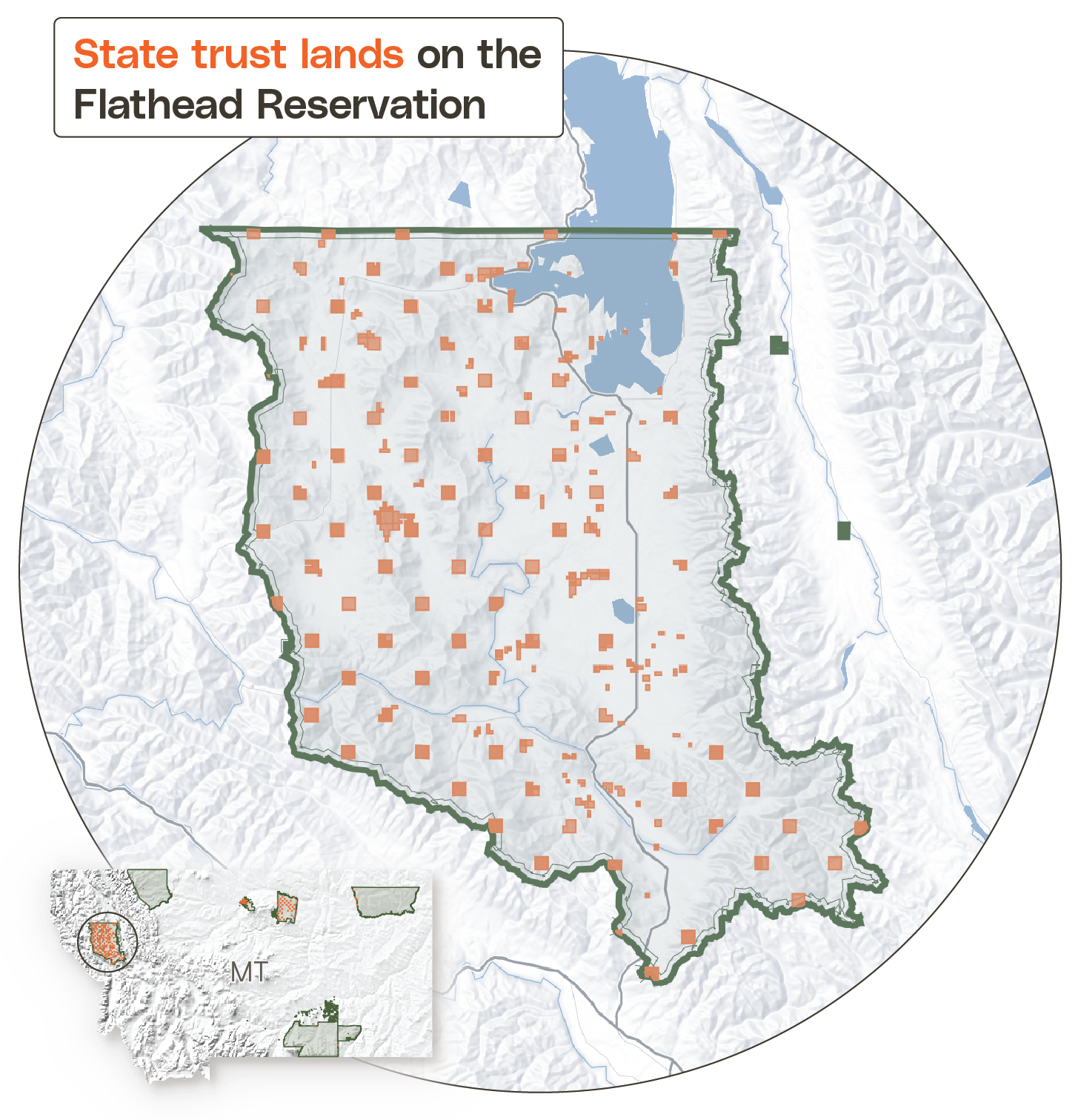
Grist has identified nearly 2 million acres of state trust lands — an area larger than the state of Delaware and broken into more than 20,000 surface and subsurface parcels scattered across the western U.S. — that are reserved for state prison systems in 10 states. In 2024, those state trust lands disbursed an estimated $33 million in funding to carceral facilities and programs. In reality, the figure is likely higher, as officials in Wyoming and Utah did not respond to requests for updated financial data for this story. North Dakota, Utah, Montana, and Idaho all use trust lands to fund detention facilities and systems for children. The land was taken from 57 Indigenous nations, through 71 land cessions, some of which are still contested to this day.
Clayton Aldern / Grist / Ales Krivec / Unsplash
Clayton Aldern / Grist / Ales Krivec / Unsplash
To acquire those lands, the U.S. paid less than $1.5 million to tribes through legal treaty agreements. However, more than a third of the lands were taken through military action with no reimbursement to Indigenous nations for their stolen territories.
“There’s a direct link between incarceration and the history of land theft our communities have endured,” said Sunny Red Bear, a member of the Cheyenne River Sioux Tribe and associate director of organizing for NDN Collective. “Our ancestral lands were taken, disrupting our traditional ways of life and governance. Displacement led to economic hardship and social challenges that have made our communities more vulnerable to the criminal justice system.”
Across the U.S., Indigenous people are incarcerated at a rate four times higher than white people, according to the Prison Policy Initiative, a non-profit research organization dedicated to addressing over-criminalization. In South Dakota, North Dakota, and Montana, about a quarter or more of the state prison population is Indigenous, even though Native people make up less than a tenth of each state’s population. Nationally, Native youth are incarcerated at a higher rate than Hispanic, Asian, and white people combined.
“The priorities are not to build treatment centers; they’re not to help with the healing our communities are needing,” said Red Bear, who has helped lead efforts to pressure officials in Rapid City, South Dakota to address discriminatory policing. “The redirecting of these funds could be used for so many different things including affordable housing, or substance abuse programs, or mental health programs, or youth programs, or restorative justice programs or reentry programs.”
South Dakota Corrections spokesperson Michael Winder said that the department already remits the trust-land disbursements to the state general fund.
A spokesperson for the Wyoming Department of Corrections indicated the agency is not responsible for the over-representation of Native people among its prisoners. “Regardless of one’s ethnicity, the Wyoming Department of Corrections does not arrest, commit or release any citizens,” wrote Stephanie Dack in an email.
Although funds coming from state trust lands make up a fraction of corrections department budgets that range in the hundreds of millions, for resource-strapped tribal governments, they represent significant sums. Most tribal governments have their own justice systems — yet the money generated from trust lands only benefits state-run institutions, which are outside of tribal control.
Whose land?
Total ceded acres earmarked to benefit incarceration
Tribal acreageState acreage
Tribe
Total Acres
Total acres represent the combined surface, subsurface, and timber rights falling
within each Royce cession boundary.
*South Dakota Department of Corrections remits their revenue disbursement to the state general fund.
Source: Grist / U.S. Forest Service
Chart: Clayton Aldern / Grist
Where a crime is committed defines where an Indigenous person will be sent to serve a jail or prison sentence. In some states, like Wyoming and South Dakota, courts send tribal citizens to state prisons when their crimes are committed off-reservation. If committed on reservation, that person can end up in a tribal or federal detention center. In other words, the justice systems that send tribal citizens to state prisons operate with little influence from tribal nations.
“There’s so many people on this reservation afflicted by addiction and trauma that’s caused by the government coming in and taking our land,” said Terri Smith, who is in charge of the new Northern Arapaho Reentry Agency, which works with Northern Arapaho peoples who are reestablishing their lives after incarceration. The agency began accepting clients, including Steven Amos, in August. “If money is being generated off those lands, it should go back to those original tribes and help them become healthier people.”
Smith, who was formerly incarcerated herself, said Amos’s experience isn’t unique. Most people from Wind River who are released from prison end up going back. Sometimes it’s a matter of access to basic resources, like transportation or gas money to traverse Wind River’s vast approximately 3,500-square mile expanse. Smith said, “80 percent of my job is giving people rides.”
Leading up to the 20th century, the federal government used threats of military violence, starvation and kidnapping to coerce and steal land from Indigenous nations. Native people were initially thrown into U.S. prisons as punishment for fighting that theft. Land grabs and imprisonment often went hand-in-hand, while treaties and Indian policy at times included language bringing tribal members under the jurisdiction of the U.S. or states’ criminal law. Andrew Jackson’s Indian removal policies in the 1830s, for example, were fulfilled in part by the Georgia militia, who rounded up and imprisoned Cherokee people who refused to abandon their land.
The Arapaho peoples once lived across a wide territory that included what is currently Wyoming, South Dakota, and Colorado. In the 1860s, officials pressured some tribal members into signing away swaths of their land in order to accommodate an influx of gold miners and to make way for Colorado to be established as a territory and Kansas as a state. In the 1870s, 74 Arapaho, Kiowa, Cheyenne, Comanche, and Caddo people, including several who survived the Sand Creek Massacre, were imprisoned at Fort Marion in Florida, as punishment for their rebellion during the Red River War, which was fought to repel U.S. forces from the Southern Plains. The Northern Arapaho were eventually pushed onto the Wind River reservation in present-day Wyoming, occupied already by the Eastern Shoshone, with whom they had recently been at war.
“One way to think about these kinds of transitions in containment is as part of a continuum of war on Indigenous people to remove them from land,” said Shiri Pasternak, an associate professor in criminology at Toronto Metropolitan University , who helped develop an Indigenous Abolitionist Study Guide for the Yellowhead Institute, an Indigenous-led research and education center.
Laws designed to forcibly contain Indigenous peoples continued to evolve. For nearly a century, being an Indigenous person essentially became illegal. With the passage of the Indian Religious Crimes Code in 1883, Indigenous people faced incarceration if they practiced their religions. The first Indian Boarding School, Carlisle, was founded after Lieutenant Richard Pratt experimented with using militarized education to assimilate the prisoners of war at Fort Marion. The prison provided a model for the network of schools built to strip children of their language, culture, and family connections. Those boarding schools have become the subject of investigation and scrutiny in both the United States and Canada in recent years.
“You get to the horizon and you see the result, the impact, the outcome of centuries of state violence reflected in the prison population,” said Pasternak.
About 172,000 acres of Northern Arapaho land is now earmarked for carceral beneficiaries across Wyoming, South Dakota, and Colorado. In Colorado, some of the Northern Arapaho acreage that makes up the state’s Penitentiary Trust is physically occupied by two prisons: Limon and Sterling. In Wyoming, it accounts for a portion of the trust land funds that go to state prisons — the rest was taken from the Crow, Goshute, Shoshone, Bannock, Cheyenne, and Sioux nations.
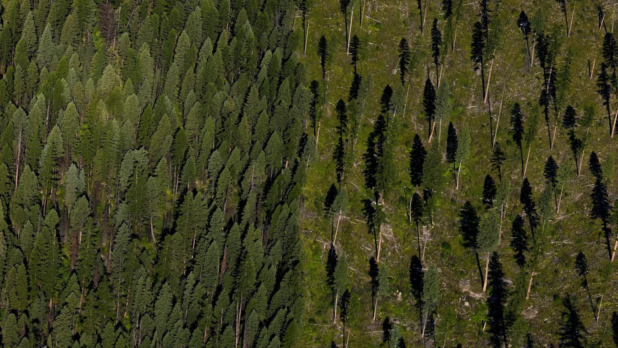
States generate revenue on these trust lands by leasing acreage out to extractive industries like oil and gas projects, mining, grazing, timber harvesting, renewable energy development. Over half of the trust land that funds prisons, a total of over 1.1 million acres, are used for subsurface activities, including fossil fuel extraction, accelerating climate change and its impacts.
Clayton Aldern / Grist / Stephan Seeber / Chris / Unsplash
At the same time, the unequal representation of Native people in prisons means that tribal citizens will be disproportionately impacted by the climate crisis. People in prisons tend to be particularly vulnerable to extreme weather. During storms and wildfires, prisoners are often left behind as communities evacuate. Flooding can create fetid conditions, while wildfire smoke exacerbates asthma. Power outages at times leave people trapped in cells with overflowing toilets, poor ventilation, and a lack of food and water.
Idaho has one of the highest numbers of state-run carceral facilities facing extreme wildfire risk, according to a 2022 analysis by the Intercept. Its prisoners are even sent to fight the fires for at most $1.50 per hour. In 2024, trust lands provided over $5 million to Idaho’s prisons.
Heat is the most pervasive climate risk factor for prisoners, who disproportionately experience health conditions or take medications that make them sensitive to high temperatures. None of the states that receive trust land funds have fully air conditioned prisons, according to a 2022 analysis by USA Today, though some use a combination of air conditioning and swamp coolers, which don’t work well in humid weather. That means that when temperatures spike, people die. A two-day heat wave in the west means a mortality increase of 8.6 percent in prisons, according to a recent academic paper.
Of the state corrections departments that use trust land to pay for prisons, only Arizona, which took in $2.3 million in trust revenue last year, has facilities located in places that experience 50 or more days annually of heat indexes over 90 degrees. By 2100, with slow action on climate, state detention facilities in South Dakota, Idaho, Utah, Colorado and New Mexico will see similar levels of heat.
To address worsening heat, deteriorating buildings, and other issues like overcrowding, some state governments are making major investments in detention facility infrastructure. “Instead of looking deeper into root causes of why our mothers and aunties and grandmothers are being incarcerated, what they’re doing is building more prisons and expanding our jails,” said Red Bear from NDN Collective.
Pasternak, the criminology professor, pointed out that prisons do more than put people away. “Prisons are a highly productive form of revenue for states because they bring in funding and jobs. Criminalization empowers a whole network of actors within society,” she said. However, there are alternatives. She added, “If the state, instead of collecting that rent to pay for prisons, was doing something different, in a way where those revenues could be shared back to Indigenous people, we’d have a different economy.”
During Steven Amos’s time in South Dakota’s state penitentiary, known as The Hill, violence reigned, and the summers were so hot he’d sleep on the floor.
Amos’ time at The Hill began with an arrest in Rapid City, South Dakota, where the Oglala Sioux Tribe recently demanded a U.S. Department of Justice investigation into discriminatory policing. State prison sentences often begin in reservation border towns and nearby communities with reputations for discriminatory policing. Amos was also arrested in Riverton, Wyoming, which sits in the middle of the Wind River Reservation but is not tribal land due to court rulings that have removed the town from tribal control.
Terri Smith, with the Northern Arapaho Reentry Agency, said most of her clients on Wind River who spent time in state prison, including Amos, were arrested in border towns like Riverton.
“I see the effects that these forced policies on Natives have caused — putting us on these reservations, genocide, assimilation policies,” she said. Returning Arapaho resources to the nation, she continued, would be a better use of the funds currently paying to incarcerate its members.
For now, Amos is doing his best to focus on stability. Smith’s reentry program helped him get tools needed for his job. He plans to build a home for his daughter one day.
“Sometimes you get stuck in a hopeless situation, and it’s hard to get out if you don’t have support and something to look forward to,” he said. For now, though, he feels strong.
A tiny scrap of land within the bounds of the Wind River Reservation in Wyoming has become the center of a heated debate. The roughly two-acre site is home to the Pilot Butte Power Plant, a defunct hydroelectric station that a local irrigation district is interested in taking over and rehabilitating.
The Midvale Irrigation District approached the Bureau of Reclamation, the federal entity that controls dams and other irrigation infrastructure, with the proposal in 2022. The situation to Steve Lynn, the manager of the irrigation district, seemed to work for just about everyone. The plant could be utilized to produce hydroelectric power for the community. There are very few clean energy projects in Wyoming, and this one at maximum capacity could power about 50 households on average per day, a substantial amount for a sparsely populated region.
But the project has run up against opposition from the Eastern Shoshone and Northern Arapaho, the Indigenous tribes that share the Wind River Reservation. The tribes oppose the transfer because the land in question was ceded to the federal government under duress. Even if the irrigation district takes over the plant, it would be of little benefit to the tribal members of Wind River. The district does not serve the reservation.
Last year, United States Senator John Barrasso and Wyoming’s lone House Representative Harriet Hageman introduced the Pilot Butte Conveyance Act to transfer ownership of the land to the Midvale Irrigation District, bypassing tribal approval. The move has led to multiple protests by tribal members. Last week, around 20 tribal members gathered in the cold, held signs that read “Respect Indigenous Sovereignty,” waved tribal flags, and chanted in downtown Lander, Wyoming. The Wind River Inter-Tribal Council, the governmental unit that represents the Northern Arapaho and the Eastern Shoshone, also passed a resolution in December opposing the Act, stating that they were not “consulted, engaged, or notified of the legislation.”
“This is an erosion of tribal sovereignty,” Eastern Shoshone tribal member Sharolyn Jimmerson told Grist. “They wanted to pass this through without anybody noticing.” The issue is bigger than just the two acres, she said, and touches on old tensions between tribes and non-Natives.
The fight over this small dormant plant highlights the history of federal and private entities taking control of tribal land. Millions of acres of reservation land have been taken from hundreds of Indigenous nations over the years. As the population of non-Native people grew over the centuries, the United States government took land for universities, schools, fossil fuel exploration, and agriculture from tribes. The Eastern Shoshone, for instance, were originally promised 44 million acres of land by the United States government in 1863 but ultimately only received around 2.2 million acres. The federal government also said it would designate a reservation in Colorado for the Northern Arapaho, but the tribe was eventually placed on the Wind River Reservation.
While the United States took large swaths of land to bolster agricultural projects in central Wyoming, some unused land acquired this way — deemed “excess lands” — was supposed to go back to the tribes. Since 1939, the tribes have been working to get land back through a series of consultations with the Bureau of Land Management and by advocating for legislative changes.
Whether the federal government has the right to transfer ownership of the Pilot Butte Power Plant comes down to treaties signed more than 150 years ago and an agreement ratified by Congress in 1905. The Fort Bridger Treaty of 1863 designated the original 44 million acres to the Eastern Shoshone, and in 1905 Congress passed an act allowing for white settlement within the reservation. Three decades later, Congress reversed course requiring that “undisturbed” land be returned to tribes. The Bureau of Land Management has estimated that roughly 57,000 of the 104,000 acres of so-called excess land should be returned to the tribes of the Wind River. (The tribes are requesting that the entire 104,000 acres be returned.)
As a result, federal representatives like Barrasso and Hageman as well as the local irrigation district point to the land as firmly within the control of the federal government. But tribal leaders say that since the power plant is in the middle of the reservation, they should be consulted with its fate, and it should ultimately be returned to the tribe.
Former Eastern Shoshone tribal council member Wes Martel said this land is protected under the Fort Bridger Treaty of 1863. “That’s always been the position of the tribes,” said Martel, who now works for the Greater Yellowstone Coalition, a conservation group based in Montana.
“Everything north of the Big Wind [River] was reservation land.” Martel said that the tribes are disregarded by the federal government because land not deemed on the reservation is treated like it’s completely separate from the surrounding land on the Wind River Reservation.
For Lynn, the irrigation district manager, and others in favor of the land transfer, the land was already ceded, and the tribes have no right to it.
“The land was given by treaty to the federal government,” Lynn said. “The Pilot Butte Power Plant has nothing to do with the revocation back to the tribes.” A spokesperson for the Bureau of Reclamation told Grist that the agency sent the tribes an outreach letter about the transfer of the power plant, but did not follow up when they didn’t receive a response. The Biden administration’s guidelines for tribal consultation state that federal agencies should address issues of lack of adequate consultation by creating multiple contacts between the United States and the tribes.
The future of the Pilot Butte plant is uncertain. Last month, Minnesota Senator Tina Smith and New Mexico Senator Martin Heinrich opposed Senator Barasso’s motion on the Senate floor to pass the bill citing the ongoing tribal protests in Wyoming. In response, Barasso promised to retaliate, noting that he will be “vigilant and watching out for bills that impact at least two and a half acres in their home state.”
Steve Lynn with the Midvale Irrigation District expects more support for the Pilot Butte Conveyance Act now that a new GOP-led Congress has taken office and said it would eventually pass. Lynn maintains that Pilot Butte was never explicitly included in plans to transfer land back to tribes and that they have no case.
But Jimmerson, who is part of the group Stop the Pilot Butte Conveyance Act, said she will be at the state’s capital on President-elect Donald Trump’s inauguration day to continue protesting the bill. She said that the legislation is another example of tribal interests being disregarded in favor of irrigation for mostly white families in central Wyoming.
“I don’t see how they could not think we were stakeholders in this land,” she said. “It’s heart-wrenching. We stewarded these lands for generations.”
When Deb Haaland was chosen as the secretary of the Interior by President Joe Biden in 2021, she was the first Native American ever to serve in the U.S. Cabinet. It was a seminal moment for tribal citizens: For more than 150 years, the Interior Department had been the arm of the U.S. government in charge of managing relationships with tribes, which included executing its colonial agenda. The agency helped oversee forced assimilation of Native children through federal boarding schools, where children taken from their parents were barred from speaking their Indigenous languages. Today, the department is best known for managing more than 85 million acres of national parks, many of which sit on land stolen from tribal nations.
The agency’s mandate is broad: It also oversees federal mining permits, national monuments and sanctuaries, and federal wildlife refuges, making critical decisions about conservation and mining that have implications for global biodiversity and carbon emissions. It is charged with managing U.S. relationships with island territories like Guam and Puerto Rico, and fulfilling federal trust obligations to tribal governments, including funding for health care and education. Most recently, the agency has funneled money to tribes to help them with climate change adaptation and, in some cases, relocation.
When Haaland, an enrolled member of the Laguna Pueblo tribe, was tapped to lead the agency, she was serving as a congressional representative for New Mexico.
“A voice like mine has never been a Cabinet secretary or at the head of the Department of Interior,” Haaland said in 2021 ahead of her congressional confirmation vote. “Growing up in my mother’s Pueblo household made me fierce. I’ll be fierce for all of us, our planet, and all of our protected land.”
Four years later, as Haaland’s tenure ends, her presence in the Interior Department has led to greater collaboration with tribal nations and broader awareness of America’s crimes against its Indigenous peoples. She launched the Indian Boarding School Initiative, which produced an investigative report on the boarding schools and led to an official apology from Biden. Under her leadership, the Interior Department has executed more than 400 co-stewardship agreements to enable Indigenous peoples to have more of a say over their ancestral lands. Haaland also pushed for historic funding for tribal nations and stronger consultation with Indigenous leaders.
But not everything Haaland and the Biden administration have done has been heralded by environmental and Indigenous advocates. Biden reneged on his campaign promise of no new drilling to approve the Willow Project, which opened vast swaths of Alaska for oil drilling and is expected to add more than 249 million tons of carbon dioxide to the atmosphere over the next three decades. And while progress on co-stewardship and co-management agreements have been welcomed by tribal nations, some continue to question whether the administration has done enough to prioritize returning land back into trust.
Grist spoke with Haaland about her experience and what she hopes her legacy will be. This conversation has been condensed and edited for clarity.
Q: What do you hope your legacy will be? What part of it are you most proud of?
A: One of those pieces (of my legacy) is the Boarding School Initiative. Nothing had ever been done like that before. This was an era of American history that a lot of mainstream Americans didn’t know about. Indian Country knew about it, and it plagued us. It was generational trauma that so many tribal communities have suffered. But we brought attention to that. We will continue to shine a light on it. And I hope, in a way, that we’ve been able to bring about healing as a result of all of the work that we have done.
Q: What was the hardest part of your job?
A: There are so many decisions that are difficult. I can’t really think of one in particular. Some folks don’t realize that there’s a process to everything, and there’s so much that you have to consider when you are making a decision. It’s particularly difficult when you have communities on either side of an issue: One is saying, Please do this. The other one is saying, Please don’t do this. Those are hard decisions to make, right? I promised that I would manage the Department of the Interior and our public lands in a balance. And so, I feel like I’ve really tried to do that.
Q: At the time that the Willow project was approved, Politico reported that it was a difficult decision for you to make. Looking back, what do you think about the approval of that project? Do you have any regrets?
A: That was definitely a difficult decision — folks on one side of the issue and other people on the other side of the issue. I think that in the end, the people of Alaska spoke. This wasn’t a new project that just popped up during the Biden administration. There had been contracts that had been signed in years past. It had been going through this process for like 20 years. And so by the time it came to us, it was just really time to make a decision. And there were valid existing rights that we had to consider. We have laws in our country. Contract laws are our contract laws. And when people have valid existing rights, you have to consider those. In the end, I feel like we did what needed to be done at the time.
Q: The Biden administration has been praised for improving the tribal consultation processes for so many projects, but there are still many that are proceeding against the wishes of the Indigenous peoples. For example, the Dakota Access pipeline, Line 3, even mining at Oak Flat. What would you tell our readers who are concerned about those projects moving forward, and are disappointed that they’re still moving forward even under your tenure?
A: Just to be clear, we (the Interior Department) don’t have a say in those projects at all. But with respect to the projects that we have, we have to move forward. We have really worked hard to make sure that tribes have a voice. You’re never going to have 100 percent consensus. There’s tribes who are for it. There’s tribes who are against the tribes. They’re not a monolith. They don’t all think the same. They don’t all speak the same. So the public comment periods and the processes that we have in place for these issues, we really just encourage people to make sure that they are using the process to their best ability.
Q: Recently, you announced a new plan to preserve and revitalize Native languages, counteracting years of systemic suppression. This was exciting to a lot of advocates who’ve been fighting for this, and is particularly timely as climate change threatens Indigenous languages. But where will this money come from now that we’re facing a Republican-controlled Congress and a second Trump administration?
A: Congress holds the purse strings. And so this would be an issue for Congress to take up. And our hope is that there will be enough members of Congress who recognize that this is something worthy of our country getting behind. Something that united all of those communities is that they said, over and over again, Our language was not lost. It was stolen from us. Native languages encompass so much more than just communication. It includes geography. It includes tradition and culture. COVID really worked against the preservation of Native languages, because so many elders passed away during the pandemic. And so it is an urgent issue.
Q: To clarify, there’s no guarantee that this will be funded under the new administration, right? What do you expect its future will be, knowing that such funding is unlikely over the next four years?
A: I was a member of the House, so I recognize how difficult sometimes it is to get things passed through the Congress. But it doesn’t mean you stop trying. And so, as I have told many of my career staff, I’m going to be cheering for them from the sidelines. I think many people across the country and across Indian Country will be pushing the Native language plan forward and hoping that they can convince members of Congress that it is worthy of Congress’ support.
Q: The Biden administration facilitated more than 400 co-stewardship agreements, which many communities are happy about. At the same time, there are also a lot of people who have been calling for land to be returned back to tribes through the landback movement, putting land back into trust for their Native nations. What would you say to those who think you’ve prioritized co-stewardship over landback? Looking back, what have you accomplished in terms of landback?
A: I don’t think we’ve prioritized co-stewardship agreements over landback. If tribes want land into trust, they contact us — there’s a process that it goes through in order to put land into trust for tribes. It’s a continuous process. We have put a lot of land into trust for tribes. But it is up to the tribes. We are upholding the trust and treaty obligations of our nation’s 574 federally recognized tribes. If the tribes want something, they contact us, we work on it. I understand how important it is for tribes to have their land into trust. And of course, if that’s what the tribes want, they come to us and we work on helping them in any way we can.
Q: We’re facing a Republican-controlled Congress and the Trump presidency. What parts of your legacy do you think can withstand those forces and prevent being reversed?
A: Under the Investing in America agenda, President Biden moved $45 billion into Indian country, and that has been used to make the lives of tribal folks better across the country. That is not getting clawed back. We have the Federal Boarding School Initiative that is now in an oral history project stage. President Biden made an apology to Indian Country. He signed a proclamation for a national monument for the boarding schools. He’s apologized. There’s no taking that back.
You might have heard of Governor Lewis (of the Gila River Indian Community) with an amazing solar energy project on his tribal lands. These are all things that happened under this administration. And so it would be difficult to claw things like that back. I’ll mention one last thing to you: The (Native American Graves Protection and Repatriation Regulations) regulations: We consulted with tribes. They told us what they wanted. We got those across the finish line. These are all enduring things, enduring progress that we have been able to actually complete during this administration.
What will the next administration do? It’s hard for me to think about hypotheticals. But I can tell you, what I hope is that the career staff will continue to do their amazing work, that tribes will continue to have a voice in their federal government, and that we’ll all be able to continue to move these important issues forward.
The crowd sways like starlings in murmuration as we wait for the show to start. The relaxed vibe belies the pandamonium about to be unleashed. Metal concerts are like that. To an outsider, they appear violent, and they can be, but to fans like me they are a place of solace.
I’ve been attending concerts since I was a teenager; the first was in a dusty parking lot and I never looked back. At the time, I gave no thought to what amplifiers cranked to 10 might do to my hearing, and it didn’t help that I liked being close to the action. Tonight, in Denver, I’ve got earplugs, sensible sneakers, and, because it has been acting up, a brace on my knee.
The lights dim and my pupils dilate. The band starts and my adrenaline spikes. The music is loud, but I don’t care. I push toward the stage, the sound becoming a roar, thrumming in my ears. A circle opens in front of me. I’ve reached the pit, where dozens of bodies swirl in a vortex, pushing and colliding with each other in a communal dance called moshing that is both an individual act of catharsis and a collective expression of emotion.
A baby metal concert I attended in 2023.
Excitement pounds in my chest. It’s been another rough day, in a series of rough days. I’m Arapaho and Shoshone. And like all Indigenous peoples, our land is exploited, our sovereignty denied, our future imperiled. But it’s the accumulation of everyday microaggressions that make me angry. I not only live with this, I write about it, and I can’t help but get mad.
I jump in.
The ongoing brutality committed against Indigenous peoples — land grabs, genocide, continuing disregard for self-determination and sovereignty — bolster a culture of over-consumption and play an undeniable role in the climate crisis. Given that anger is a hallmark of heavy metal, it isn’t surprising that an Indigenous audience would find it appealing.
Although often associated with Satan, swords, and sorcery (and illegible logos), metal has always reflected on the environment and the state of the world. Indigenous bands have been part of the scene almost from its start more than five decades ago, but the past few years have seen a growing number of Native musicians writing about a wide range of subjects, from rurality to discrimination to the universal experience of having a good time despite all of that.
Metal is famously opaque, with around 70 subgenres, but it is almost universally accepted that everything started with Black Sabbath in 1968. Even as that British quartet was laying the foundation, XIT, pronounced “exit,” was singing about the Indigenous experience on its 1972 album Plight of the Redman.
XIT, once deemed the “first commercially successful all-Indian rock band,” sang frankly and expressively about colonization, poverty, and the loss of Indigenous traditions. Its politics and performances at American Indian Movement rallies prompted FBI attempts to suppress its music, but that didn’t keep XIT from touring Europe three times and appearing with bands like ZZ Top. Although their best music is delightfully of the ‘70s, it remains radical stuff.
Winterhawk, led by Cree vocalist and guitarist Nik Alexander, explored similar themes in 1979 on Electric Warriors, an anti-colonial, pro-environmental message that could have been written today. “Man has his machines in mother earth, murdering the balance weaved destruction in our doom,” Alexander sang on “Selfish Man.” The song interrogates whether nuclear energy is worth destroying the land: “They say nuclear power is alright, like light to make the night bright. But it doesn’t mean you can have my birthright, does it, selfish man?” (Then, as now, Indigenous peoples were at the forefront of opposition to nuclear power.) The band was popular enough to perform with the likes of Van Halen and Motley Crue and earned a slot at the US Festival in 1983, but broke up a year later.
As the 1970s gave way to the 80s, metal began splintering as bands like Metallica and Brazil’s Sepultura took it beyond the blues-based sound hard rock and metal were based upon. Testament, founded in 1983 and led by Chuck Billy, a member of the Hopland Band of Pomo Indians, sang about climate change on the 1989 album Practice What You Preach. In the song “Greenhouse Effect,” he refers to rainforests burning and “the world we know is dying slow” before singing “seal the planet’s fate, crimes they perpetrate, wasting precious land. It’s time to take a stand” in the rollicking chorus. Still, Billy doesn’t think many took the message to heart. “Twenty-five years later, everybody in the world realizes that, ‘Hey! Our climate has changed,’” he told Radio Metal.
While Testament spoke to the issue broadly, Resistant Culture, an inter-tribal band that started in the late 1980s (when it was called Resistant Militia), speaks to its specific impacts on Indigenous people. Its music combines punk and metal with traditional Indigenous singing and the band, which is unapologetically political (one verse in “It’s Not Too Late,” released in 2005, includes the line “your heroes are my enemies, your philosophy wants us dead”), discourages overconsumption while promoting equitable sustainability, self-sufficiency, and self-determination. “The more independent of the system we can be, the less power it will have over our lives and communities and the more resilient we’ll be as we approach an uncertain future,” the band, which speaks as a collective in interviews, told the music blog Blow the Scene.
Nirvana’s 1991 album Nevermind pushed grunge into the cultural mainstream. But metal did not die, it evolved. The two decades that followed saw it atomize into dozensof subgenres with different vocal styles, tempos, sonic textures, and lyrical themes. Indigenous bands were in lockstep with this global explosion, with bands like Mi’Gauss exploring their heritage on Algonquin War Metal, and Brazil’s Corubo addressing anti-colonialism and environmentalism in songs often sung in the Guarani language. Although Sepultura is not an Indigenous band, it worked with the Xavante Indigenous community on the album Roots, an exploration of Brazil’s history with colonization. Biipiigwan explicitly critiques the impact of Canada’s governmental policies on tribal communities.
Metal has, in recent years, grown more explicitly concerned with climate and the environment, with pagan- and folk-infused bands bringing an element of spirituality and pre-colonial romanticization. Pre-colonial Scandinavian bands like Warundra explore traditional Pagan worship that was the norm before Christianity. This connection with nature is more than vague gestures to a pan-Pagan past, according to Kathryn Rountree, an anthropologist at Massey University who wrote a paper on the topic. For Indigenous peoples, it is “connected to this-worldly social and political concerns.”
I’m in the pit when I fall and bang my head on the floor. Strangers immediately help me back to my feet, but someone with a strong shoulder and a rogue elbow sends me down once again. Ouch. I throw myself deeper into the fray, shoving my shoulder into someone twice my size. They shove back, but I hold my footing.
To civilians, the pit looks chaotic. But it has a current, ebbing and flowing with the music and the emotions of the audience. I move against the crowd because it’s more fun that way. My cheek is sore from yet another fall earlier in the night. Few thoughts go through my head. I just want to move; feel something.
The pit is one of the few places where being aggressive doesn’t make me seem like an angry Indian. I am angry, but metal concerts are about more than aggression. They’re about being able to express yourself, release frustration, and feel something akin to power. As an Arapaho and Shoshone from the Wind River Reservation, it’s nice to feel like I have some of that.
Courtesy of Taylar Stagner
There’s an argument to be made that metal is the most expansive and inclusive genre of music, with bands from scores of nations and backgrounds. Alien Weaponry infuses its music with Te Reo Māori, the Indigenous language of Aotearoa New Zealand, and explores Māori culture, history, and socio-political themes. The Hu incorporates traditional Mongolian instruments and throat singing in a style of music they call Hunnu rock inspired by ancient tribes.
Women are an increasing presence in Indigenous metal. Blitz is a one-woman band started by a musician who goes by the name Evil Eye. In addition to incorporating tribal music, she draws influence from bluegrass and classical. Singer-songwriter Sage Bond combines acoustic guitar with metal in compositions that often draw from Navajo creation stories and her own experiences to comment on justice, resilience, and unity in the face of systemic racism. Takiaya Reed and Sylvie Nehill of the Australian band Divide and Dissolve write slow, almost trudging, highly experimental and occasionally dissonant instrumental music. Their music has been called “an organic release of anger” and “an excavation of buried horrors.”
Indigenous bands come from all parts of the United States, but Navajo Nation has a particularly vibrant community, with bands like Signal 99, Mutilated Tyrant, and Morbithory — the unholy trinity of Diné metal. Filmmaker and professor Ashkan Soltani Stone spent five years there, an experience he recounts in the book Rez Metal: Inside the Navajo Nation Heavy Metal Scene. He found a tight-knit community of musicians who focus on environmental issues and the experience of living in Indian Country, but also refuse to be pigeonholed. “Everybody expects them to be political and deal with very serious topics,” he said. “But in my opinion, they are just badass musicians.”
Not a lot happens in rural communities, and for many Indigenous youth, metal provides an antidote to boredom. Much of the live music is country, and getting to a concert often requires a long drive. Stone said many bands simply want to create a lively local scene, have some fun, and travel. “They are just like everyone else,” he said. “They are stuck on a reservation where there are not many opportunities. But the music is there.”
Landyn and Ayden Liston are the first to say they started Dogs Throw Spears simply to be part of Navajo Nation’s metal scene and get into shows for free. Though Landyn said “we are the last to say what genre we are,” they jokingly call themselves “Native raw dog metal” and play a style of music called death metal — a subgenre characterized by heavily distorted guitars, growled vocals, and complex rhythms. In the short time they’ve been performing, they’ve seen the number of people attending concerts, and starting bands, balloon. “These past two years bands have been coming out of nowhere,” Landyn said.
Although the band’s raw, aggressive songs explore Indigenous identity and their community grapples with weighty issues — Landyn specifically mentioned the high rate of suicide — Dogs Throw Spears has a lot to say beyond the bad in lyrics that sometimes veer toward cryptic. The song “Veggie Tales,” for example, tells listeners, “Fresh air, safe sex, rest well, beware. Breath in, breath out, fatigue, aware.”
“Don’t just read off the surface,” Landyn said of the band’s songs.
Thriving scenes and engaging bands can be found almost everywhere. Pan-Amerikan Native Front from Chicago highlights Native battles against colonizing forces and, in its own words, “the fierce resistance indigenous peoples of the ‘Americas’ have endured throughout centuries of colonial and post-colonial occupation.” The Salt Lake City band Yaotl Mictlan blends black metal — a style marked by shrieked vocals, fast guitars, and low-fidelity sonics — with Mesoamerican instruments and languages in a style it calls “pre-Hispanic metal.” Its early work focused on the Zapatista movement in Mexico. Tzompantli, (which means “skull rack” in the Indigenous language Nahuatl) is from Pomona, California, and celebrated Aztec, Mexica, and Chichimeca history on its crushing anti-colonial album Beating the Drums of Ancestral Force. Blackbraid, the one-man black metal band led by an artist who identifies himself as “south Native,” often reflects on his relationship to the natural world and ongoing resistance to genocide and oppression.
Many of these bands are singing about all the same things XIT and Winterhawk sang about in the 1970s, including Indigenous persecution, environmental degradation, and the historical and present state of colonialism. Little has changed in 50 years, and in some cases things have grown worse. Ultimately, that may be what unites Indigenous metal bands and fans the world over. Despite coming from many tribes, communities, and countries, the destructive force of colonialism, and the degradation of the environment, is something we all share.
Documentaries, books, and articles are incredibly taken with Indigenous peoples and metal, and on some level those beyond Indigenous communities can understand how difficult it is to be Indigenous right now. Native people around the world are fighting a seemingly never-ending battle with colonialism.
Instead of giving into despair, metal provides a productive way to engage with the state of the world. The themes that these musicians explore are universal to the Indigenous experience. That is an awful truth, but also beautiful in its solidarity.
Grist
By the end of the night, I’m coming down off the excitement and a little sore. The pit will do that. As I get older, I know I can’t keep doing this. The exhilaration that comes with attending a concert, of being part of the crowd, takes a toll. I’ve got bruises alongside the alien tattooed on my arm, giving him a black eye. He looks worse than I do.
A sea of metal fans files out of the venue into the winter night air. I bump into someone and we start talking. I’ve always found it hard to make small talk, but we chat about the show, what bands we like, and how cold it is.
“You Native?” they ask. Taken aback, I say yes, face flushing. “Hell yeah.” They fist bump me, and disappear into the snow. I never know how to respond to something like that, but it leaves me smiling. That small connection makes the night seem a little brighter, friendlier.
The air is dry and cold but refreshing as I start the long trip home.
It was barely a choice. In 1855, a time when the ink of border lines on United States maps had scarcely dried, Yakama Chief Kamiakin was told to sign over the land of 14 tribal nations and bands in the Pacific Northwest — or face the prospect of walking “knee deep” in the blood of his people.
Legend has it that, when he put pen to paper, he was so furious he bit through his lip.
By signing, he ceded over 10 million acres across what is now known as Washington state. In return, the Yakama Nation was allowed to live on a reservation one-tenth the size of their ancestral lands, about 100 miles southeast of Seattle.
But the story doesn’t end there. The treaty map was lost for close to 75 years, misfiled by a federal clerk who put it under “M” for Montana.
With no visual record to contradict them, federal agents extracted even more Yakama land for the nascent state, drawing new boundaries on new maps. One removed an additional 140,000 acres from the reservation, another about half a million, and still other versions exist.
By the time the original map was discovered in the 1930s, it was too late. Settlers had already made claims well within reservation boundaries, carving the consequences of this mistake into the contours of the land. Non-Native landowners remain to this day.
The Yakama want that land back. Most tribal members know the story of Kamiakin and his bloodied lip when he signed the treaty. Ask Phil Rigdon, a Yakama citizen and nationally recognized forester. As the superintendent of the Yakama Nation Department of Natural Resources, he deals with a medley of issues, but his most important work is getting the reservation land back. After working on this for nearly 20 years, he knows that it takes time and an entire community to make the progress they want.
“It’s a family thing for us, as we do this business,” he said.
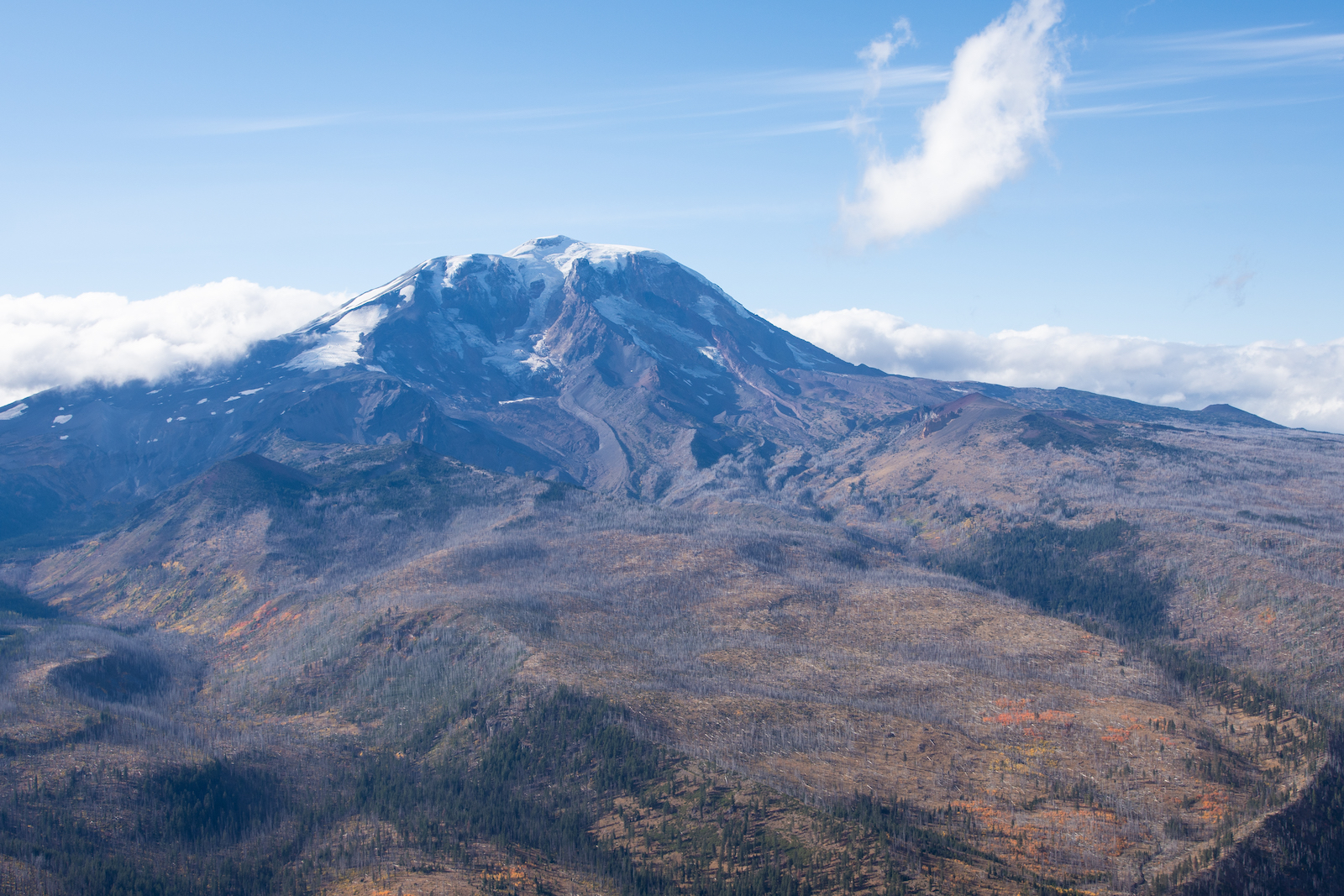
Pahto, also known as Mount Adams, looms over the western edge of the Yakama reservation. In 1972, President Richard Nixon signed an executive order acknowledging that the mountain had been mistakenly excluded from the reservation. Maria Parazo Rose / Grist
Pushed up against the eastern slopes of the Cascade Range mountains, the Yakama reservation is over a million acres — but not all of it belongs to the tribe. The primary non-tribal landowner on Yakama Nation is the state of Washington, which owns close to 92,000 surface and subsurface acres of state trust land within the reservation’s boundaries, in addition to other types of land holdings.
As part of the Enabling Act of 1889, the federal government gifted tracts of land to states when they graduated from territories to join the Union. These parcels, known as state trust lands, are considered resources in perpetuity: States can sell or lease these lands to make money from grazing, timber, and other activities. The profit is then used to fund a state’s institutions: universities, jails, hospitals, and, especially, public schools.
These lands can be a meaningful revenue source. A Grist investigation from earlier this year found that state trust lands across the Western U.S. that send money to land-grant universities paid out about $6.6 billion dollars from 2018 to 2022.
Washington’s state trust lands, including those on the Yakama reservation, are managed by its Department of Natural Resources, or DNR. The state is eager to return the lands back to the tribe; it recognizes that a return would both complete the Yakamas’ ownership of the reservation and support the region’s environmental health. However, the state’s efforts are dictated by legal policies and priorities that ensure the land is exchanged only on the condition that Washington is compensated for the lands’ value, even though it was wrongfully taken.
Grist has reported on over 2 million acres of state trust lands that exist within the borders of 79 reservations across the Western U.S. Our investigation has shown that extractive industries, like mining, logging, and oil and gas drilling, operate on that land that generates billions of dollars for state entities. But the Yakama Nation’s history with state lands is singular in its legal morass.
When the treaty map was “misfiled,” two main areas on the reservation were repeatedly depicted as non-tribal land on incorrect replacement maps. One is along the northern border of the reservation, known as Tract C. The other is Tract D, in the reservation’s southwestern corner.
Today, nearly 71,500 acres of surface and subsurface state trust lands on Tract D, and 19,700 acres on Tract C, send revenue to Washington’s institutions, mostly benefitting public K-12 schools. The map the Washington DNR uses to reference the Yakama reservation still marks Tract C as a “disputed area.”
Prior to settler colonialism, the ancestral Yakama homeland
stretched for 10 million acres — from Pahto (Mount Adams) in the
west past Nch’i-Wàna (the Columbia River) in the east.
In 1855, the Territory of Washington was just two years old, and
settlers aimed to make it a state.
That year, the United States forced a treaty upon the people of
Yakama Nation, who were subsequently confined to a reservation —
ceding roughly 90 percent of their more than 10 million acres.
To establish the reservation, negotiators relied on natural features
to define its boundaries.
6Yakama Nation v. Klickitat Cnty.
Commencing on the Yakama River, at the mouth of the Attah-nam
River; thence westerly along said Attah-nam River to the
forks;thence along the southern tributary to the Cascade
Mountains;thence southerly along the main ridge of said mountains,
passing south and east of Mount Adams, to the spur whence
flows the waters of the Klickatat and Pisco rivers;thence down said spur to the divide between the waters of
said rivers;thence along said divide to the divide separating the waters
of the Satass River from those flowing into the Columbia
River;thence along said divide to the main Yakama, eight miles below
the mouth of the Satass River;and thence up the Yakama River to the place of beginning.
The according treaty text and map illustrated a reservation that
stretched from the Cascade Range eastward to the Yakima River, with
a southern boundary south of Mount Adams.
But the treaty map disappeared shortly after the treaty's
signing, throwing the reservation boundary — especially the
southwestern edge — into dispute. Subsequent federal surveys would
seek to delineate this boundary.
The Schwartz survey, conducted in 1890, cut nearly a half-million
acres out of the reservation relative to the understanding reached
in the treaty.
A federal report released in 1900 fixed some of the more obvious
errors of the Schwartz survey but failed to appropriately reflect
the southwestern boundary of the reservation.
The Supreme Court ruled in 1913 that the Yakama reservation extended
to the main ridge of the Cascade Range. In the early 1920s, a new
federal survey implemented this correction — but still used an
unnatural straight line to denote the southwestern side.
Despite the recovery around 1930 of the 1855 treaty map, which
prompted a new federal survey of the boundary in 1932, the
southwestern boundary of the Yakama reservation would remain in
dispute.
This 120,000-acre section of land, highlighted in a mid-20th-century
Yakama claim to the Indian Claims Commission, became known as Tract
D.
The litigation of Tract D — which appropriately captures the natural
geographic boundaries of the 1855 treaty — would define the next
seven decades of Yakama land claims.
Today, between surface and subsurface rights, more than 70,000 acres
of Washington state trust lands sit within Tract D.
What happened to Tract D?
Scroll to continue
Parker Ziegler and Clayton Aldern / Grist
The boundary errors have been acknowledged by authorities ranging from Harold Ickes, the Secretary of the Interior during the Franklin Roosevelt administration in the 1930s, to former President Richard Nixon in the 1970s.
But none of these acknowledgments were legally binding, said attorney Joe Sexton of Galanda Broadman law firm, based in Washington. That is, until the 2021 9th U.S. Circuit Court case of the Confederated Tribes and Bands of the Yakama Nation v. Klickitat County, for which Sexton and Galanda Broadman, along with attorneys for the tribe led by Ethan Jones, argued the Yakamas’ case.
It started with a jurisdictional dispute over a criminal prosecution: In 2017, Klickitat County arrested a minor and enrolled tribal member for a crime in Tract D. The county claimed that the tribe had no jurisdiction over Tract D, since it wasn’t reservation land; the tribe declared the opposite. The Yakama Nation sued Klickitat County for stepping outside its jurisdiction; the county argued that Tract D was not included when the reservation was created. Sexton’s job was to prove that it was.
“If they had lost this, they would’ve really been brokenhearted about the fact that future Yakamas would not be able to consider this part of their reservation,” Sexton said.
With Sexton’s argument about interpreting and honoring treaty language, the Yakama Nation ultimately won the case, confirming that Tract D was and had always been a part of the reservation, within the original boundaries. This was further validated when, the following year, the U.S. Supreme Court rejected the county’s appeal against Yakama Nation. The case also set a meaningful precedent for how the Tract C boundary, which has had no such adjudication, might be approached in court, Sexton said.
While the court’s decision was monumental, it did nothing to address the continued existence of state trust lands on the reservation.
Under the U.S. Constitution, federal treaties with tribal nations, as with other sovereign entities, are considered the supreme law of the land. Washington also has its own state Supreme Court decision, which expressly holds that tribal treaties are binding law. The Treaty with the Yakama of 1855 precedes the federal 1889 Enabling Act that distributed state trust lands, so it should have precedence. In other words, because the treaty was signed first, the subsequent expansion of state trust lands on Yakama land, due to incorrect maps, shouldn’t have happened.
“The Treaty of 1855 trumps it,” Sexton said. “There’s no question about that.”
But because of how Western property law works, the state has legitimate legal claim to those lands.
It goes back to how the U.S. perceived its right over the land upon which it was building itself: Empowered by the Doctrine of Discovery, a Catholic decree authorizing colonial powers to claim land, the government decided that all of the land and everything on or under it was federal property until it was turned into a state, or national park, or reservation. Whoever had the property deed, which was initially held and then granted by the federal government, was in charge. And deeds are the key to ownership, Sexton said, seen to be almost as powerful as treaties, even though they’re not listed in the Constitution.
So despite the fact that the U.S. gave away Yakama land to which it no longer had any right, because it fell within the bounds of the reservation, the federal government’s distribution of trust lands to Washington state is still recognized as a legal transaction.
Washington has the ability to decide how these trust lands are handled. But because so much time has passed since the state’s inception in 1889, generations of settlement and ownership have been established in the area, and state beneficiaries have come to count on trust lands as a revenue source — which means it is unlikely that Washington would return the trust lands on the reservation to the tribe without some form of compensation.
“State officials, they’ll claim that the law ties their hands. But I don’t know that it does,” Sexton said. “And if it does, they’re certainly not working to change the law in any actual way.”
Klickitat Meadow, like many of the forest meadows on Tract C of the reservation, is where the headwaters of the Klickitat River begin. Many Yakama tribal members come to this closed part of the reservation to hunt and gather food, and learn about the land. Maria Parazo Rose / Grist
The October sun shone through fall-colored leaves above the truck Phil Rigdon drove into the forests of Tract D. Along a rolling ridgeline, he pointed out groves of pine stands.
“We call this area Cedar Valley, even though there’s no cedars here,” Rigdon said, gesturing out the window. “It was the homesteaders that called it Cedar Valley. And so I don’t know why it stuck.”
Rigdon stepped into the superintendent role for Yakama Nation’s Department of Natural Resources in 2005, coming with a bachelor’s degree in forest management from the University of Washington and a master’s degree from the Yale School of the Environment. He steers land management across the entire reservation. But before that, Rigdon was a forester. In these backroads, he recognized copses of trees he once knew as saplings he planted decades ago, now stretching 40 feet tall.
“You never think you grow up, but holy shit,” he said. “Now you’re like the big trees, you’re the old growth.”
Driving through Tract D, there was a clear contrast between different parcels of the forest. Some were densely packed or dotted with stumps — those owned and managed by the state or private interests. The forest on tribal land, meanwhile, was thinned out, full of mature trees with thick trunks. Branches stretched into air. Thinning out trees has many purposes: It decreases the material that feeds wildfires, it enables a more complex plant system, and it slows the spread of insects and disease. It creates a healthier forest.
Both the state and private industry harvest timber more aggressively than the tribe, though Rigdon acknowledged that the state manages forest much better than private industry, which does more clear-cutting. After all, the state DNR must manage state trust lands so that schools and other institutions receive revenue years into the future.
This isn’t to say the tribe doesn’t log. They cannot tax people, as a tribe, so they harvest enough to help fund their government institutions, which partly depend on timber as a revenue stream. But the Yakamas’ approach is to view land as a continuum, to be managed for the very long run. They pay attention to the overall environment, making decisions based on what allows the entire ecosystem to work as it should. Their harvesting practices double as a way of maintaining forest health — the priority over revenue generation.
“What we leave on the ground actually is usually more valuable than what we take,” Rigdon said.
The tribe values land for more than its potential economic worth: There is kinship, memory, medicine.
Like when Joe Blodgett, a tribal member and Rigdon’s cousin, described the Klickitat Meadow, he didn’t bring up the golden grass or jagged peaks on the horizon. He talked about weekends fishing with his dad. Klickitat Meadow is in the Tract C part of the reservation, checkerboarded with state trust lands and tucked up in the mountains behind roads that require four-wheel drive. This area, and others like it, is where Blodgett and other members of Yakama Nation learned to gather food and about their connection to the land.
“It gets back to the importance of what our resources are offering us,” Blodgett said. “They’re making a sacrifice, they’re making that offering. And we’ve got to appreciate that.”
Blodgett manages the Yakima Klickitat Fisheries Project, a tribal initiative that works on restoring sustainable and harvestable fish populations. His work involves overseeing environmental restoration projects, like in the Klickitat Meadow, which has been far too dry. A warmer climate played a part in this, but the full reason is more nuanced. A history of state-sanctioned sheep grazing permitted on adjacent state trust lands led to grazing on the meadow that never should have happened. Large herds, which wouldn’t normally be in the area, compacted the dirt so much that water can no longer percolate into the ground to feed the streams and rivers that start in mountain meadows like this.
Actions that damage the environment in seemingly small ways add up, Blodgett said. Scale matters. But by the same token, small environmental mitigation practices also add up to meaningful improvements. In a meadow stream nearby, for example, the tribe has built human approximations of beaver dams that slow the water and help it absorb into the ground. Solutions like these are called “low tech,” but the simplistic name belies their necessity for other projects to succeed.
For example, the U.S. Army Corps of Engineers is ready to move forward with the removal of the Bateman Island Causeway, an unauthorized, artificial land bridge in the Columbia River that connects Bateman Island to the shore. Tribes have long advocated for its removal, given its disturbance to the surrounding ecosystem. Removing it will restore fish populations off the reservation, but Blodgett said the situation won’t get better without cold water coming down from the mountain streams on the reservation. That’s where the low-tech fixes come in.
“They’re equally important,” Blodgett said of the low-tech fixes and bigger infrastructure projects. “You’re going to see the biggest bang out there when you pull that causeway out. But if [fish] don’t have these types of systems to go back to, you’re just going to continue to spin your wheels.”
Climate change adds pressure to the Yakamas’ environmental restoration efforts. Because the effects of a rapidly changing environment are becoming more prevalent, Blodgett and other Yakama experts know that they have to take faster, bigger action to stay ahead of and be resilient to even harsher future conditions. It will require landscape-scale restoration projects, more sustainable management of forests, and smarter water- and land-use practices — big projects for which the Yakama Nation would need cohesive control over its reservation, without pockets of state or private ownership.
The Yakama Nation has a plan for land reclamation. The tribe began buying land back from companies and private landowners in the mid-1990s, returning close to 40,000 acres. One of the bigger single acquisitions was a deal with a private landowner to buy back roughly 7,500 acres in Tract C for about $5 million. But the remaining 19,700 surface and subsurface acres of state trust land in Tract C have proved to be elusive; the tribe has been negotiating to reacquire those lands for over 20 years.
The complications come from the Enabling Act rules that govern Washington state’s financial responsibility to its beneficiaries: The state cannot lose money from state trust lands. In practice, were the state to return trust lands to Yakama Nation, it would need to be paid however much that land is worth, or receive land that is the equivalent value of what they exchange. Without that compensation, public schools and other institutions will feel the financial pinch.
Between 2021 and 2023, the state trust lands within Yakama reservation generated $573,219.85 — which is .16 percent of all the revenue that state trust lands across Washington state produced in that same time period.
Washington does have one avenue for transferring state trust lands from the DNR to other entities, as long as those lands are deemed financially “unproductive.” The Trust Land Transfer program’s benefit is that the state legislature funds land exchanges, instead of an entity, like a tribe, buying it back. But you have to have a legislature willing to do that. It’s a unique program, one that the DNR says they operate in the spirit of collaboration with the tribes.
The state trust lands on Tract C are eligible for this program and are on the final list of this year’s proposed transfers, with “minimal long-term revenue potential.” The state DNR has requested $15 million from the state legislature to return roughly 9,900 surface acres to the tribe. Per state policy, the state would retain the rights to any subsurface materials under these lands, even if the surface rights go to the tribe. The DNR would use the payment money to purchase new lands in place of the transferred trust lands, to continue supporting beneficiaries.
Comparatively, Tract D, which courts confirmed is a part of the Yakama reservation, is still productively generating revenue and not eligible for the Trust Land Transfer program. The legislature could theoretically fund a direct transfer to compensate the DNR and its beneficiaries for the Tract D state trust lands, but that would be a hefty price tag. So, instead, the state has brought in the federal government to facilitate an exchange, given that it has more resources and holds so much land in the area. The DNR has identified federal lands off reservation that they want and now it’s a matter of negotiation, said Commissioner of Public Lands Hilary Franz.
“The reason this situation exists is because the federal government created a situation of injustice to the tribes. To right the situation doesn’t mean you create a wrong,” Franz said, explaining that giving those trust lands away without an exchange would unfairly take revenue away from schools and other beneficiaries. “It means, federal government, you made the wrong allocation of lands to the state for trust lands, when it should have gone to the tribe. Now, correct that … and you make the tribes whole and you make our schools whole.”
Franz said that if the legislature doesn’t approve funding for the Tract C Trust Land Transfer — though she is confident they will — the DNR would likely approach it in the same way as Tract D, negotiating with the federal government for a direct transfer. Otherwise, the alternative would be the arduous process of amending the state constitution and federal Enabling Act. But, Franz said, that’s too hard. Hard, but not impossible. Section 11 of the 1889 Enabling Act, dealing with lands granted to support schools, has been amended eight times, most recently in 1970. Washington’s state constitution has been amended 109 times, one of the most recent in 2016 for a redistricting issue.
The state legislature will decide whether or not to fund the Tract C trust land transfer in the spring of 2025. But no matter how the issue of trust lands is resolved between the Yakama Nation and Washington state, it sets a meaningful example for tribes on the 78 other reservations where trust lands exist.
One cool morning last October, about 170 years after the Yakama treaty signing, a crowd of about 90 people gathered in a dusty clearing next to the Klickitat River on the southwest corner of the Yakama reservation, in Tract D. Cupped by pine-covered hillsides, they were there to commemorate the groundbreaking of long-awaited upgrades to the Klickitat Hatchery.
On October 11, 2024, the Yakama Nation hosted a groundbreaking ceremony for updates to the Klickitat Hatchery. Seen here are Yakama staff, joined by Tribal Chairman Gerald Lewis (far left) and Tribal Councilman Jeremy Takala (far right).
Maria Parazo Rose / Grist
It had been run by the state until 2006, when it was turned over to the tribe; tribal members have managed it back to health, holding things together with duct tape and determination. Over the low rumbling of river water, representatives from the county, state, federal, and tribal governments praised the collaborative effort that had gone into restoring the hatchery.
The tribe was also celebrating the forthcoming return of the land the hatchery is located on. On December 13, Washington state transferred the title to the 167 acres and all the hatchery facilities from the state Department of Fish and Wildlife, or DFW, to the Yakama Nation.
Bill Sharp, coordinator for Yakama Nation Fisheries’ projects, has worked on environmental restoration projects for 35 years. He’s white, a non-tribal member. To him, navigating the title transfer with the DFW has been faster and easier than land transfers with the state DNR. The presence of state trust lands on the reservation, he said, is an insult to injury.
“Can you just clean the slate, say, ‘Our bad, here it is, all back’? That’s how it should go,” Sharp said, about the state trust land return efforts. “But the way things were funded, and the easements and restrictions that white people put on top of that — those things just really get in the way of doing what’s right.”
What is the right way to settle an injustice? Who is justice for? Rigdon, Blodgett, and other Yakama experts working on this issue know that land return is a long game, even on their own reservation. They’re in it for the very long haul, which means that each new challenge is just another day — and that every win, like with the hatchery, is cause for celebration.
“I’ve always had the opinion that you can never lose if you never stop trying,” said Sharp. “So as long as the Yakama are here, and they live and breathe, they’re going to keep fighting to protect the resources that sustain their lives. And we all benefit from that, everyone, whether you’re a tribal member or not.”
At the end of the ceremony, the faint smell of a warm, fresh salmon meal slipped into the air, prepared by Yakama staff for the festivities. After the closing speeches, the crowd moved like a wave, chattering about this and that while they waited in a winding line. A row of tables held trays of salad, salmon, bread, and grapes. Folks from state and federal organizations sat with their tribal counterparts, full plates in hand. The Klickitat County commissioner was there, her presence marking a fresh page in the tribal-county relationship.
Kids squirmed in plastic chairs before bolting across the grass to play between bites. The salmon was simple and smoky, well-salted. People ate what they wanted and took what they needed. Some came up for second helpings. Anyone could walk away with a heavy box of leftovers for a later meal. For a moment, at least, there was no competing for resources or space. There was enough to share.
In the first-ever global study of its kind, researchers concluded that more attention needs to be paid to physical attacks and threats against land defenders, since those incidents often are the precursor to death.
Last year, a human rights and environmental watchdog group determined that 177 land defenders were killed in 2022. Land defenders are people who seek to protect their communities and environmental resources from destructive development projects ranging from pipelines to mines to farms to wind projects.
This month, however, the Alliance for Land, Indigenous, and Environmental Defenders, or ALLIED, found that there were 916 non-lethal incidents in 46 countries in 2022 — or about five for every death. Non-lethal incidents range from written and verbal threats to kidnapping or detention to physical assaults. The probable perpetrators identified by ALLIED include paramilitary forces, police, local government officials, private security guards, and corporations.
“While police was the commonly named probable perpetrator of the violence, often we see state actors operating on behalf or at the request of other parties, including private businesses,” said Eva Hershaw, who co-chairs ALLIED as part of her work with the International Land Coalition, where she heads their global data and land monitoring.
ALLIED drew on news outlets, social media posts, eyewitness interviews, court filings, and police reports to make its conclusions. The group’s researchers consulted data sets from 12 organizations and talked with affected communities in these countries to assure accuracy. Roughly a third of the organizations that ALLIED worked with used locally based data collectors who confirmed acts of violence with municipalities. For many of these data collectors, this was the first time their data has been used in a global study, Hershaw said.
Of the 916 incidents that didn’t lead to death, nearly a quarter of the victims were Indigenous, despite the fact that Indigenous people make up only 6 percent of the global population. With respect to the assaults and threats that often lead up to killings, “Indigenous Peoples were disproportionately targeted with such violence,” Hershaw said.
Violent attacks and threats against Indigenous land defenders are often underreported due to victims’ fear of retaliation. Also, attacks often happen in rural places away from the eye of the media. The report detailed repeated violence and harassment against individuals as well as whole communities.
Among the most violent places for Indigenous land defenders were Colombia, Guatemala, and Mexico, which together accounted for 75 percent of all attacks and threats. Across the 46 countries included in the report, land defenders who spoke out against industrial agriculture and mining were the most at risk.
Philippe Le Billon, a professor at the University of British Columbia who focuses on natural resources and armed conflicts, said this data is important for preventing further violence and should be utilized to develop transparency that doesn’t exist in a lot of places. “Early warning mechanisms need to be developed using this data,” he told Grist. He said companies need to hold themselves accountable to the communities in which they operate and develop procedures to address conflicts when they arise.
Risk factors for violent incidents included vague and undefined land rights in a particular nation. When private businesses or infrastructure developments are already present in a community, that can increase the risk as well. Around 40 percent of violent incidents happened while the victims were actively protesting development projects that threatened their land or communities.
Another risk factor is what the report calls weak rule of law. “Weak rule of law indicates that laws are not properly or equally enforced,” said Hershaw, meaning that laws that were supposed to protect Indigenous land defenders did not lessen the threats.
Verbal and written threats were the biggest act of violence documented in the report, comprising 33 percent of all non-lethal incidents. Arbitrary detentions — the act of detaining someone without evidence or without following legal due process — made up 10 percent of the incidents.
According to the report, around 30 percent of all non-lethal incidents in 2022 targeted not individuals but entire Indigenous communities. For instance, the Tumandok, an Indigenous people living in the mountains of the Philippines, have a long history of conflict with various development projects.
In 2018, six tribal members were killed, then a steady stream of violence and killings led up to the forced removal of Tumandok people to make way for a hydroelectric dam. The Philippine government is courting projects in the mining sector as well, and other tribal communities across the country have decried the government’s disregard for Indigenous rights.
As mining operations increase worldwide in the service of the energy transition, Indigenous people are at greater risk of potential violence. The report recommends that national governments better document attacks and create stronger legal protections for vulnerable communities. ALLIED also says corporations need to be held accountable for violence and threats that advance their business interests.
Hershaw gave one example of what accountability could look like: This year, Hudbay Minerals settled three lawsuits filed a decade ago by the Q’eqchi’, an Indigenous Mayan group in Guatemala. The Q’eqchi’ alleged that the Canadian-owned company was responsible for the sexual assaults of nearly a dozen women and the killing of a community leader during a land rights dispute. The Q’eqchi’ were compensated for an undisclosed amount.
Le Billon said that pursuing compensation for the loss of loved ones and land is incredibly difficult for tribal communities. “Court cases are hard to put together,” he said. “You need lawyers. It costs money.” Le Billon said information and documentation, like the data ALLIED uncovered, is hard to get and it takes a lot of time to collect, creating another barrier for environmental land protectors seeking justice. “These things can last decades, literally.”
At COP30, the United Nations climate change conference slated to take place next year in Brazil, ALLIED plans to release data on non-lethal attacks in 2023 and 2024.
Julian Aguon wore a dark blue suit and garland made of white coconut fronds, brown hibiscus tree bark, and brown cowry shells. Under the arched ceilings and chandeliers of the Peace Palace in The Hague, he stepped to the podium to make his case to the International Court of Justice.
“The right to self-determination is a cornerstone of the international legal order,” Aguon told the 15 judges who make up the court. “Yet climate change, and the conduct responsible for it, has already infringed the right to self-determination for the many peoples of Melanesia.”
The International Court of Justice, or ICJ, normally hears disputes over lands and waters between countries, but sometimes it takes on cases of broader global resonance. This was one of them: Aguon was arguing on behalf of Pacific island nations thousands of miles away that hope to hold accountable the countries most responsible for climate change. The 42-year-old attorney from Guam spent five years working toward this moment, along with his co-counsel, Margaretha Wewerinke-Singh. Now, he sought to underscore what was at stake.
“The peoples of Melanesia live exceptionally close to the Earth, and thus feel the vandalism visited upon it acutely,” he said. “Moreover, theirs represents living, breathing alternative imaginations — imaginations other than the one that has brought this planet to the brink of ecological collapse. Thus, ensuring they are able to live and thrive in their ancestral spaces is of the utmost importance, and not only for themselves, but for all of humanity.”
A group of climate activists waves flags from Pacific island nations in front of the International Court of Justice on December 2 as as lawyer Julian Aguon argues a major climate case. Lina Selg / ANP / AFP) / Netherlands OUT via Getty Images
Aguon grew up on Guam, the son of a plumber and a social worker. His childhood consisted of playing in jungles with his cousins, where elders warned them to avoid anything metal in case it was leftover ordnance from World War II; family gatherings to pray the rosary in the Chamorro language; and absorbing a cultural devotion to serving one’s community. His dad worked short stints for various employers, including at a naval ship repair facility, and died of pancreatic cancer when Aguon was 9. Aguon has wondered if his death was related to U.S. military pollution.
At the time, his father’s death led his family to disintegrate, and Aguon buried himself in books like The House on Mango Street, the story of a Chicana girl growing up in Chicago — a coping mechanism that deepened his empathy and drive for justice. A quote from James Baldwin resonates with Aguon today: “You think your pain and your heartbreak are unprecedented in the history of the world, but then you read.”
“Grief so often has an isolating effect that it need not have,” Aguon told Grist. “I feel like my grief has been a bridge that I’ve walked across to get to other people.”
Julian Aguon as a small child in the 1980s, with his sister and grandma outside of their Tamuning house on Guam.
In the 1990s, when Aguon was a kid, a massive typhoon hit Guam. The windows and sliding glass door in his home shattered, and Aguon, his brother, sister, and mother propped a mattress up in their living room and hid behind it. Aguon remembers tracing the mattress’ embroidered flowers with his finger as the family waited for the winds to pass. Years later, he would read a report from the Intergovernmental Panel on Climate Change that predicted the coming of even stronger cyclones.
“At that moment I was like, ‘Wow, we’ve already been through so much,’” he said. How much more extreme would the storms get? How much more would his community have to endure? “I had a really shocking sense of the scale.”
The case before the ICJ, led by Aguon’s law firm, Blue Ocean Law, hopes to establish legal consequences for nations that have driven climate change, and illuminate what obligations those countries owe to people harmed.
The court is being asked to provide an advisory opinion to clarify the legal obligations of countries under existing international law. Aguon describes it as a request for an objective yardstick by which to measure those countries’ actions, which could open the door to a new era of climate reparations.
Ten-year-old Julian Aguon speaks on the one-year anniversary of his father’s death.
After Aguon and Wewerinke-Singh exited the courtroom last week, they joined a press conference before the palaceʻs marble staircase near its front entrance. Ralph Regenvanu, Vanuatu’s top climate official, told reporters that the island nation deliberately chose Blue Ocean Law to represent them at the ICJ because the Indigenous-led firm would not only represent them legally, but culturally.
“This is a case about our identity as Pacific Islanders, our human rights as citizens of this planet, and the responsibilities that states have to ensure our human rights and our cultural identity and our essence and our future is protected,” Regenvanu said.
If the ICJ delivers the advisory opinion Vanuatu is seeking, Aguon hopes Indigenous peoples will be able to leverage that opinion in climate-related lawsuits against their governments and file human rights complaints against both countries and corporations. Given the climate impactsIndigenous peoples are already experiencing, the stakes couldn’t be higher.
In the summer of 2010, then-28-year-old Aguon was just a year out of law school and was looking for a job after finishing up a clerkship with Guam’s Supreme Court. He wanted to work in international and human rights law, but no firms specialized in that on Guam, the largest island in the Pacific region of Micronesia that’s home to about 160,000 people. Well-established lawyers on the island discouraged him from trying to start a new firm from scratch: Why not work for a few years, get some more experience, they suggested.
“They were right, in some ways,” Aguon said. “I did lack experience, but I didn’t necessarily need the experience that they had, because I wanted to do something different.”
What he envisioned was a law firm that could advocate on behalf of Indigenous peoples in the Pacific: communities like the Marshallese, which are still fighting for justice after decades of U.S. nuclear testing; like the people of Tuvalu, where rising seas are threatening to eliminate entire islands; and the Chamorros, like Aguon, where an ever-expanding American military presence increasingly stresses the island’s lands and waters.
To accomplish that, Aguon would need to be licensed to practice law in multiple countries. He spent months studying for and passing bar exams not only on Guam, but also in the Marshall Islands and Palau. He opened a solo law practice in 2010 in a tiny office in the village of Hagåtña, Guam’s capital. At first he worked locally, providing legal counsel to Guam’s Legislature and defending the island government’s plans for an Indigenous-only vote on the island’s political status. As his workload grew and his clientele expanded, he opened up Blue Ocean Law in 2014, and began to hire staff attorneys who saw the law the way he did: as a tool for social change that is both severely limited and potentially emancipatory.
“We are a small team of activist lawyers, social change lawyers,” Aguon said. His colleagues include his ICJ co-lead Wewerinke-Singh, who has worked on climate litigation across multiple regions and U.N. courts; Alofipo So’o alo Fleur Ramsay, a Samoan attorney whose environmental justice work in Australia and in the Pacific has earned her chiefly orator titles from two villages in Samoa; and Watna Mori, a Melanesian lawyer from Papua New Guinea whose expertise in human rights and environmental law extends to advocacy for legal systems that value Indigenous knowledge systems.
Blue Ocean Law now includes seven attorneys, whose work spans Melanesia, Micronesia, and Polynesia, the three major regions of the Pacific.
Over the next decade, Aguon argued for Guam’s right to self-determination before a U.S. federal appeals court in Honolulu, defending the island’s effort to limit a vote on Guam’s political status to Indigenous Chamorros. (Chamorro is also spelled CHamoru, but Aguon prefers the former). He lost, and Guam has yet to schedule a vote.
Julian Aguon and his colleagues walk outside of the Peace Palace in The Hague after arguing the world’s biggest climate case. Michel Porro / Getty Images
But Aguon is still proud of one aspect of the judges’ decision, which recognizes a legal distinction between racial and ancestry classifications. “From now on, for all Indigenous peoples living under U.S. rule, there is now a case that formally and comprehensively disentangles those two concepts, which means that Native peoples throughout the country can cite it to argue that some ancestral classifications are not the same as racial classifications,” he said.
After losing in federal court, Aguon and his team took their advocacy on behalf of the people of Guam to the United Nations. The island is still formally recognized by the U.N. as a colony, and first became an American military outpost at the turn of the 20th century. For decades, the U.S. refused to grant Chamorros U.S. citizenship, and instead forced them to live under a carousel of capricious naval governors who banned everything from the Chamorro language to interracial marriage to whistling.
“Law is the vocabulary of the powerful in so many instances,” Aguon said. “The U.S. military was probably my greatest teacher in that regard.”
His firm has advised the Marshall Islands’ government on its legal options as it continues to contend with the legacy of U.S. nuclear tests. Aguon and his colleagues have also worked with organizations and legislatures in Pacific countries like Fiji to consult on the risks of deep-sea mining.
Aguon’s team has filed complaints about human rights violations by the U.S. military against the Chamorro people with the United Nations, prompting three U.N. rapporteurs to issue a joint letter in 2021 criticizing the U.S. for denying the Chamorro people their right to self-determination.
Just last month, Blue Ocean Law filed a complaint with the U.N. Rapporteur on Indigenous Peoples on behalf of youth from Palau who say U.S. militarization in their islands is violating their rights, including their right to freely consent to what happens on their land.
“We’re consistently taking on the U.S. empire in all of these cases,” Aguon said.
In 2006, the same year that Aguon went to law school, the U.S. military proposed a massive expansion of its presence on Guam, deciding to move its Marine Corps base to Guam from Okinawa after local opposition to the soldiers’ presence became impossible to ignore. (At the heart of the anti-military protests were concerns about American soldiers’ sexual violence against Okinawan women and girls, including the 1995 rape of a 12-year-old by two Marines and a Navy sailor.)
Between the 8,000 service members, their 9,000 dependents, and the tens of thousands of construction workers and other staff needed to create more facilities for the new base, the military estimated there would be an influx of 80,000 people on Guam, increasing its population at the time by more than half. “It’s good for the strategic interests of America,” retired Marine Corps Major General David Bice told the Guam Chamber of Commerce in 2007. “It’s good for our friends in the Pacific, and it’s also good for Guam.”
The community balked. Aguon felt that the military used language to obfuscate rather than illuminate the reality of their impact on Guam. For example, “live-fire training” was a euphemism that could refer to anything from machine gun firing to large-scale bombing practice. “Environmental impact” encompassed the destruction of cultural sites dating back more than 1,000 years. “Readiness” referred to the military’s ability to respond to threats, but it wasn’t always clear whether the Indigenous people were among those the U.S. cared about protecting.
“The law is about hyper-vigilance, hyper-attentiveness to how language is being used and deployed,” Aguon said. “Often it is being weaponized against people most in need of this protection.”
Julian Aguon argues before a panel of 9th U.S. Circuit Court of Appeals judges in Honolulu on October 10, 2018. The question before the judges in Davis v. Guam: Should non-Native residents of Guam have a say in the territory’s future political relationship with the U.S.? Jennifer Sinco Kelleher / AP Photo
Litigation and community protests forced the Department of Defense to shrink its military relocation to 5,000 troops, and change the location of its planned firing range. The new Marine Corps base opened last year, and a machine-gun practice range is being built adjacent to a federal wildlife refuge.
Aguon sees the law as a single tool among many to push back against this entrenched militarism that he sees echoed around the world, from Honolulu to Gaza. To him, what will ultimately effect change is solidarity.
“We’re up against such huge, gigantic, colossal forces,” Aguon said. “I’m casting my net of hope in that direction, that the peoples of the world — from the ground up — can really find more effective ways to confront these forces that we’re up against.”
In 2017, Aguon sat in Straub Hospital in Honolulu and held the hand of a longtime mentor, Marshallese leader Tony de Brum, who is known internationally for his global leadership in fighting climate change. De Brum had served as a father figure after Aguon’s dad passed and helped inspire his passion for climate justice. “Give them hell,” de Brum said, before he too died. Four years later, Aguon was named a Pulitzer finalist for a screed on climate change in the Pacific: “To Hell With Drowning.”
When Vanuatu asked for his law firm’s help with its climate change case five years ago, Aguon hadn’t ever argued before the ICJ and wasn’t intimately familiar with the particularities of its proceedings.
The ICJ only accepts cases brought by U.N. member states, and because the U.S. never relinquished Guam, the island territory doesn’t have the right to file cases there. The same is true for countless Indigenous nations throughout the world whose borders are missing from most maps: The highest court in the United Nations doesn’t have a seat for them, and so their voices are rarely heard. That echoes other venues of the U.N., where Indigenous peoples are often left out of key negotiating rooms because their nations don’t have U.N. member state status and they lack representation within their colonial governments.
A group of climate activists demonstrate in front of the International Court of Justice in The Hague, Netherlands, on December 2. Lina Selg / ANP / AFP / Netherlands OUT via Getty Images
“The ICJ proceedings are more state- and international-organizations-focused, less people centered, where engagement by civil society is quite restricted, and Indigenous peoples do not have a direct pathway for engagement in the court,” said Joie Chowdhury, a senior attorney at the Center for International Environmental Law who has also assisted on the climate case. That’s in contrast to other U.N. legal venues like the Inter-American Court of Human Rights and the International Tribunal for the Law of the Sea, she said. “So there is no easy pathway for Indigenous peoples’ engagement, and especially in this case, that would be important given their tremendous knowledge and expertise in climate change and biodiversity.”
Sometimes, nongovernmental organizations may intercede, as in this ICJ case where a dozen were approved to participate. In addition to representing Vanuatu, Aguonʻs team is also representing the Melanesian Spearhead Group, a nongovernmental organization that consists of Melanesian Pacific island states. The organization also includes the Kanak Socialist National Liberation Front, which represents the Indigenous Kanak people of New Caledonia who are fighting for independence from France.
Bringing a case before the ICJ requires specific knowledge and meaningful funding, and often parties are represented by a cottage industry of attorneys who specialize in the ICJ and are familiar with its proceedings. This is only the second time that a Pacific state has sought an advisory opinion from the ICJ. The last time was in 1996, when the Marshall Islands asked the judges to weigh in on whether detonating or threatening to use nuclear weapons violated international law. The judges said that it may be legal in extreme cases of self-defense.
“Many of these countries that have never argued before the ICJ before are actually not just coming to argue their case, but leading from the front,’” said Chowdury from the Center for International Environmental Law. “It is showing and demonstrating to the world that this is an avenue of justice.”
Representatives from Pacific island nations gather outside the International Court of Justice on December 2. More than 100 nations and organizations are seeking an advisory opinion from the top U.N. court on what countries are legally obligated to do to fight climate change and help affected nations mitigate its impact. Michel Porro / Getty Images
Just getting on the court docket is a challenge and, in this case, required getting a resolution approved by the U.N. General Assembly. The case was originally launched in 2019 by law students at the University of the South Pacific, who took a ground-up approach to persuading U.N. General Assembly members in the Pacific and beyond to formally request an ICJ advisory opinion. As their campaign grew, Aguon found himself and his staff providing input at all hours of the day every time a word or comma changed in the draft that circulated among U.N. delegates.
The case morphed into the largest-ever in ICJ’s history. Overall, 97 countries and 12 nongovernmental organizations are urging the court to weigh in on what major polluting countries owe to the peoples and nations who have been harmed by their relentless carbon emissions. Aguon spoke on the first day, but oral arguments were scheduled for the first full two weeks of December. It’s not clear when an opinion will be rendered.
In the meantime, Aguon hopes that not only the court but the world will pay attention to the stories that the case is revealing about the cost of climate change to Pacific peoples. During the press conference near the entrance of the Peace Palace, he told the story of one of the villages he visited when collecting witness testimony for the case.
“There is a village at the mouth of a river in the Gulf province of Papua New Guinea, that is on the move again. The people of Vairibari, whose ancestors have lived along the banks of the Kikori River Delta since time immemorial, have already moved four times due to sea level rise. This will be their fifth and final relocation. Final, because there is simply no more inland to go,” Aguon said.
“A planning committee has been formed to handle the logistics. Among other things, the villagers are debating about how best to relocate the remains of their deceased relatives, because storm surges have already begun washing away the dead. The people of Vairibari want nothing more than to stay. But climate change is making that option all but impossible.”
It’s the ABC, the original home of the saying ‘All sizzle, no sausage’, so it’s always possible we’re all going to be spectacularly disappointed. But its new series Eat The Invaders looks to be the tastiest morsel the nation’s broadcaster has brought us all in a very long time.
Starring likeable future mega-star and ‘Aboriginal man about town’ Tony Armstrong, and “with the help of scientists, land carers, an artist and a chef” the series will “attempt to turn our unwanted ecological trash into desirable culinary gold, in a provocative attempt to Eat The Invaders”.
Or in Armstrong’s plainer and more accessible English, “[We’re trying] to see if we can turn Australia’s most destructive invaders into high cuisine”.
On the menu, apparently, are feral deer, rabbit, camel, carp, cane toad and even cat. Or so the teaser strongly infers.
A screenshot from the trailer promoting the upcoming ABC series ‘Eat The Invaders’, due out in 2025.
A personal prediction… the ABC is as conservative as most mainstream news outlets, even more so in some regards. If Aunty is actually brave enough to document an attempt to cook and serve cat, then I’ll volunteer to eat it.
But if the trailer is anything to go by, that’s what’s happening, and it (the trailer) at least, is delicious.
The series, at least on the surface, ticks a LOT of boxes. The name of the show alone – Eat the Invaders – is a nod to the more ‘radical’ elements of Black Australia… ‘radical’ in this case referring to the vast majority of Blackfellas, who still to this day hold crazy notions of things like ‘Treaty’ and ‘Sovereignty’ and ‘fairness and equity’… and in this case, eating invaders.
My early tip is they mostly can’t (although deer and rabbit taste okay, and you could do worse than camel… although you need to put a bit of effort in). But it’s ultimately irrelevant – the series is very obviously primarily interested in shedding light on the environmental damage we’ve wrought on this country, and the way it’s doing it (from an Indigenous perspective), is very, very clever.
Without having even watched the series – all I’ve seen is the same trailer you’ve now all seen – I give it 4.5 stars out of 5. It’ll likely get the 5 once I’ve watched it. On that front, we won’t get to see it until 2025… I’m hoping they launch it on January 26 (Invasion Day), which’ll really set the ‘cat amongst the pigeons’, so to speak. Although another tip… they’re way too gutless for that.
Either way, credit where it’s due, Eat The Invaders is a genuinely brilliant concept. We all wait with ‘baited’ breath.
Earlier this week, tens of thousands of people converged on Aotearoa New Zealand’s Parliament in a show of solidarity against a legislative onslaught against Indigenous rights.
They had marched peacefully for nine days, in what Māori peoples call hīkoi, in an effort to stop the country’s new right-wing government from forcing through a bill that would dilute Indigenous influence on the government by reinterpreting one of its founding documents.
“Māori have been here, we are going to be here forever. You’re never going to assimilate us,” said Catherine Murupaenga-Ikenn, one of the Māori activists who participated in the hīkoi. “This is a great time for revolution.”
Proponents describe the Treaty Principles bill as a push for equal rights for all citizens of Aotearoa, which is how Māori refer to New Zealand: an effort to define principles underlying the Treaty of Waitangi, an English-language agreement signed by some of the country’s colonizing founders and Indigenous Māori that gave the Crown the right to govern the nation in exchange for enshrining Māori rights.
“Did the Treaty give different rights to different groups, or does every citizen have equal rights? I believe all New Zealanders deserve to have a say on that question,” said David Seymour, a member of Parliament who leads ACT New Zealand, the country’s right-wing party. (Seymour has Māori ancestry, but leaders of his tribe do not claim him.)
But Māori opponents say the measure would weaken Indigenous rights that not only help address long standing social and economic inequities but are critical to protecting the country’s lands and waters.
“That redefinition could diminish Māori participation and environmental governance, as the treaty currently ensures that Māori involvement in managing national natural resources,” said Mike Smith, a Māori climate activist who has two climate lawsuits pending before the country’s high court. “So by limiting these rights, the bill may weaken the environmental stewardship practices that are rooted in Māori morals and values and thereby impact the country’s ability to address all the environmental challenges, and more particularly combat climate change effectively.”
Seymour pushed back on that characterization. “If it’s true no country can do conservation without something like the Treaty of Waitangi, the world is in trouble,” he said. “In any event New Zealand has had its current conception of the Treaty for over 30 years, and we are a solid, but not the best environmental regulator, so others clearly do better without something like the Treaty.”
The Treaty Principles bill isn’t expected to pass in the current Parliament, although it could eventually head to a referendum. But it’s just one part of a broader right-wing backlash against the significant gains that Māori have made in recent decades to win back stolen land and secure better representation and co-governance of government agencies.
“This is not just about Māori interests and rights. This is about the protection of all that we hold dear,” said Māori activist Tina Ngata who has been hosting online education sessions about the bill. “Indigenous rights have been one of the strongest roadblocks to corporate exploitation.”
Ngata was part of a successful push in 2018 to get Aotearoa New Zealand to ban oil and gas exploration in its waters. The country’s right-wing government, which vaulted into power last year, is now pushing to reverse that ban.
Smith said that even though his climate litigation isn’t specifically based on the treaty, it lends critical weight to his arguments regarding the government’s obligation to protect the environment.
A website promoting the Treaty Principles bill says it wouldn’t have an effect on co-governance of Aotearoa New Zealand’s rivers and mountains, such as the Tūpuna Maunga Authority that gives Māori tribes of Auckland a say in how the city’s volcanic mountains are managed. It would, however, remove Māori co-governance of the country’s water services, which has been controversial since the prior government announced plans to nationalize water management.
Smith sees the measure as an effort to play upon the fears of the non-Māori population and make it easier for private interests to profit. “It’s an indicator that they want to stomp on Māori rights and philosophies and worldviews. It’s an indicator that they just are refusing to fight the challenge that climate change and the global biodiversity crisis demands of us,” he said.
But he has been heartened by the huge amount of support for the Māori cause. A video of a Māori legislator leading the haka in Parliament went viral on social media, underscoring the force of the opposition, which expands beyond Māori peoples and includes a former prime minister and prominent lawyers, health care professionals, translators, church leaders, and the Waitangi Tribunal, a federal commission dedicated to reviewing Māori claims regarding the treaty.
That commission is expected to hold a hearing next week to consider the question of whether the Aotearoa New Zealand government has violated Māori rights in its response to climate change. The hearing has been overshadowed by the Treaty Principles controversy, but Smith is watching it closely. The Tribunal only has the power to make recommendations, and can’t force the government to do anything, but its findings could help strengthen Smith’s climate cases before the high court.
The debate over the treaty is complicated by the fact that the English and Māori language versions of the treaty have different meanings. Murupaenga-Ikenn emphasized that the vast majority of Māori chiefs signed the Māori-language version that never relinquished sovereignty.
Murupaenga-Ikenn said she’s been excited by how the Treaty Principles bill has spurred her people into action. She was part of a massive hīkoi 20 years ago to rally in favor of Indigenous ownership of the seabed, but last week’s gathering was far larger, with as many as 55,000 people, and activists hope it’ll bleed into more local protests and stronger voter participation.
If she saw Seymour, the ACT politician behind the bill, Murupaenga-Ikenn said she would thank him. “Thank you very much for putting a reenergized fire under my people to just shake us up and wake us up,” Murupaenga-Ikenn said. “The time is now for a revolution. Thank you, David Seymour.”
It’s November and it’s unseasonably warm as John John Brown, a Muscogee elder, works to replant peach saplings. “I haven’t had much luck growing them from seed,” he says. The reason, he thinks, is because peaches need lower temperatures.
Around him, tiny peach trees the size of pencils stand above the browning grass underneath their parent tree. Brown harvested around 200 peaches this year from his small orchard – enough for his family and neighbors – but he had competition: a fox has been poking around. “The animals know when the peaches are ripe quicker than I do,” Brown laughs. “They start coming in and stealing my peaches.”
Brown’s peaches aren’t your everyday peaches, they’re heirlooms: direct descendants of peach seeds brought across the continent on the Trail of Tears. Brown calls them “Indian peaches” while other Muscogees call them “Trail of Tears peaches”. There has been little research on this particular variety, and it’s unknown just how many genes they share with commercial peaches. While grocery store peaches are soft and fleshy, Indian peaches don’t get much bigger than a lemon and are extremely firm but sweet.
The Indian peach is threatened by climate change. Where hurricanes, flooding and higher temperatures have massive impacts on crops, including peaches, around the nation, heirloom varieties, like the Indian peach, are also threatened. This fruit, that crossed a planet, carried by traders and travelers, and eventually by a few Muscogees along The Trail before they found a new home outside Sapulpa, Oklahoma, is a connection to another time and place.
“One of the greatest gifts Creator gave me is these peaches and the ability to share these trees with our community and everyone,” Brown said.
These “Indian peaches” are direct descendants of peach seeds brought across the continent on the Trail of Tears. Courtesy of John John Brown
There are only 50 Indian peach trees on the Muscogee reservation that Brown knows of – some grow in some peoples’ backyards, and some at a local daycare – and between climate-driven changes to growing cycles and high temperatures, they face a difficult future. Luckily, they have people like Brown working to protect them.
Peach cultivation is thought to have begun around 8,000 years ago in the Yangtze Valley in China. One of the first mentions of peaches in literature appears in the fictional novel Journey to the West, written in 1592, that describes peaches as a fruit that could grant longevity and “make a man’s age equal to that of Heaven and Earth, the sun and the moon.”
From China, peaches made their way to Europe, then, to the Americas in the 1600’s on Spanish ships – the beginning of a kind-of crop exchange between the continents: potatoes and tomatoes from South and Central America went to Europe while peaches made their way to the Georgia coast, and quickly, into Indigenous diets.
“Indigenous people were already caring for and managing forests and other kinds of tree foods,” said Jacob Holland-Lulewicz at Pennsylvania State University who studies archeology and ethnohistory. “That would have allowed them to adopt peaches super quickly and know really well how to create healthy peaches.”
Within a few decades, and with the help of a vast network of trade routes, peaches made their way across the continent, as far as the southwest, where tribes like the Navajo sun-dried and stewed them.
Around 1780, thousands of peach trees tended by the Seneca and Cayuga tribes along the Finger Lakes in western New York State, were destroyed by President George Washington, in an attempt to ethnically cleanse Indigenous peoples from the region. Washington wrote in a letter to one of his generals the goal was, “to lay waste all the settlements.” He added, “It will be essential to ruin their crops now in the ground and prevent their planting more.”
In 1830, President Andrew Jackson signed into law the Indian Removal Act that led to the Trail of Tears – a death march that forced around 60,000 Indigenous people to leave their homes and move west, across the Mississippi River, to Oklahoma.
Vernon Courtwright grew up eating Indian peaches. Now 75 years old, the Muscogee elder and veteran says his family brought Indian peach seeds and planted them when they were done walking The Trail. “That was the beginning of our life and the peaches’ life in Oklahoma,” he said. When he was a child, his grandmother, Emma Bruner, was the one who taught him about how to grow and tend to the fruit. “We grew up eating these peaches.”
Courtwright says in the 1970’s he began to see Indian peaches disappear. With each passing year, there was less on the landscape. “I just knew that our orchard had to be taken care of,” he said. When his grandparents passed, he took on the work of caring for the trees, and eventually, met John John Brown who helped cultivate seeds and saplings to give out to other Muscogees.
“It’s our legacy,” said Courtwright. “It’s my family’s legacy to the tribe.”
Georgia, the Peach State, produces nearly 25,000 tons of peaches every year, but falls far behind California, which produces nearly 475,000 tons each year. Globally, nearly 24 million tons of peaches are grown each year with most coming from China.
Climate change is having a big impact on those numbers though. One of the biggest threats to the peach industry is rising temperatures. Peaches need “peach chill” – a certain amount of time in temperatures that are under 45 degrees fahrenheit. Without adequate peach chill, peach trees won’t produce, and with rising temperatures, blooms will sprout too early. In 2017, around 70 percent of peach losses could be attributed to lack of peach chill. “Lack of chill is something that we think is going to be the biggest issue for us and our industry,” said Dario Chavez, a peach geneticist at the University of Georgia. “If you are in a northern climate, you don’t worry too much about the chill. But I think they’re starting to see the physiological responses to issues with chill.”
Then there are extreme weather events supercharged by climate change that can inflict immediate, wide-spread damage. This year, Hurricane Helene killed at least 226 people. It also devastated Georgia’s agricultural economy to the tune of nearly $6.5 billion dollars.
But Helene’s path was only the beginning. Hurricanes bring flooding, which is especially bad for peaches – peach trees don’t like to be too wet and can prematurely drop fruit if under water. They’re also susceptible to diseases like brown rot which can be triggered after heavy storms.
For the Indian peach, peach chill and extreme weather aren’t as big a threat as they are in the south. However, Oklahoma is expected to become around two and a half degrees hotter in the next twenty years. Even though the peach is a resilient plant, peach chill will become an issue. Natural disasters like floods become more of a threat to the lives and livelihoods of tribal members– tribal lands in Oklahoma are the most prone to flooding in the state.
But to protect Indian peaches, and a little part of tribal history, John John Brown has been giving out saplings for the better part of a decade to anyone interested in growing them.
Brown regularly travels to Georgia and Alabama to visit the proposed Ocmulgee Mounds National Park and Preserve– located on Muscogee homelands. On his drives, he often passes peach orchards filled with the variety most Americans are used to. “You don’t think they would be able to produce peaches,” he says as he eyes the tightly-pruned rows. “They cut ‘em back real small.”
He goes down to the homelands to remind settlers in the area that the Muscogee survived despite the United States attempts at genocide and demos making canoes and bows the traditional way out of local wood during the annual Ocmulgee Indigenous Celebration. To Brown the peaches are a symbol of resilience.
“When our ancestors brought these peaches up from the south you think about how devastating it was, to lose loved ones, and not know if the seeds will sprout,” he said. “I do this to honor them, and their strength.”
This week, representatives of the Fort Yuma Quechan Indian Tribe and the Pit River Nation used the 16th United Nations Conference on Biological Diversity, or CBD, in Cali, Columbia to champion the creation of the Kw’tsán National Monument, the Chuckwalla National Monument, and the Sáttítla National Monument. The proposed move would protect around 1 million acres in California from extractive industries like mining, oil, and gas. With the U.S. presidential election less than two weeks away, California tribes are pushing the Biden administration to designate these three national monuments before a new, possibly unfriendly or uninterested administration, takes office.
Lena Ortega of the Fort Yuma Quechan Indian Tribe in the southern tip of California said that in the proposed Kw’tsán National Monument, animals like bighorn sheep and desert tortoises live amongst the Ocotillo, a cane-like semi-succulent, as well as sandfood, a fleshy parasitic plant that grows nowhere else.
“The motto for this year is ‘Peace With Nature,’” she said of the CBD meeting. “Well, we’ve always had peace with nature. We are one with the land and one cannot be separated from the other and still be healthy.”
Tribes are better at protecting biodiversity because of the long relationships they have on the land. This year, from the online research journal One Earth, researchers found when Indigenous people and local communities were meaningfully brought in, and are not treated simply as stakeholders, ecological goals had more favorable outcomes. Brazil has given around 800 square miles back to Indigenous peoples in the Amazon and the government also banned non-Indigenous people from engaging in economic activity within these lands. Brazil still weakened environmental protections that contribute to the continued deforestation of the land, but that’s happening alongside Indigenous sustainable hunting and gathering practices that have been shown to be effective for conservation goals as well.
“Landback is the ultimate goal,” Ortega said, “but this is a first step.”
If approved, the three national monuments would contribute to the state of California’s 30×30 biodiversity goals — part of an international effort to protect 30 percent of land and coastal waters by 2030. Part of that strategy is asking governments to create national monuments. And while 30×30 goals indicate wanting to hold the world accountable, Indigenous peoples from across the world point out that they have been, in many cases, violently removed from their lands, had resources seized, and excluded from decision making. The Biden administration has indicated its interest in addressing this history — hiring the first Indigenous cabinet secretary, Deb Haaland, and encouraging federal departments to respect tribal sovereignty are some examples. These new national monuments would help the U.S. reach its 30×30 goal by listening to tribes.
National monuments are created under the Antiquities Act of 1906 and allow presidents to unilaterally create protected areas on federal public lands. Tribes have utilized this power to protect important historical and sacred sites for decades, and just this year, in California, the Biden administration added around 14,000 acres of land to the Berryessa Snow Mountain National Monument and 100,000 acres to the San Gabriel Mountains National Monument.
Tribes in relationship with lands and waters protected under a national monument can enter into a co-steward agreement with the federal government to continue practicing traditional ecological knowledge to protect their homelands: deals between tribal nations and federal authorities that detail how parties will preserve public lands and resources. However, federal authorities have the final say.
While protecting land through the establishment of national monuments is a tool tribes can use, it’s not infallible. In Utah, the Hopi, Zuni, Ute Mountain Ute, Diné, and Ute make up the Bears Ears Inter-Tribal Coalition, the entity that pushed for Bears Ears National Monument. In 2016, President Obama established it, but a year later, President Trump reduced it by 85 percent, leaving the area open to extractive industries.
In 2021, Biden established the monument again and the Bureau of Land Management and the U.S. Forest Service formalized management responsibilities to co-steward the land using traditional Indigenous knowledge — sets of unique, culturally-informed information on how to best steward the land with other tribes.
A report from the Swedish University of Agricultural Sciences, tabulating international data over three decades, indicates that having Indigenous peoples as stewards of the land keeps forests healthy, which helps mitigate climate change. This intimate knowledge of ecology and local governance — that often spans beyond written history — leads to decisions like planting more trees and halting deforestation.
Brandi McDaniels is a member of the Pit River Tribe in Northern California, and spoke at CBD about the Sáttítla National Monument campaign. The proposed national monument would span the Shasta-Trinity, Klamath, and Modoc National Forests. Around two dozen geothermal development projects have been leased on these lands, and McDaniels hopes to protect the area from further development.
“These lands have been taken away from our tribes,” she said. “They’ve been mismanaged.”
Members of the Eastern Band of Cherokee Indians were looking forward to their annual Cherokee Indian Fair this year — 2024’s event was to be the 112th celebration. There were going to be Indigenous stickball tournaments, bubble gum-blowing contests, and a longest-hair competition.
But the tribe, located in the western part of North Carolina, was slammed by Hurricane Helene less than a week before the fair, with floods, destruction, and a death toll of more than 200 across the state. Some members thought maybe canceling would be for the best.
To Hicks, the gathering was more important now than ever, as a way to collect donations for those in need and to “honor our traditions while supporting those who need it most.”
Big country musical acts who were playing the fair, like the headliner, Midland, urged attendees to bring nonperishable food items and bottled water for those affected by the hurricane. And after the five-day celebration wrapped up on October 5, tribes from all over the region are continuing to come together to support the Eastern Band of Cherokee Indians, which was one of the most affected by Hurricane Helene.
Funds to repair damages are often harder for tribes to access, so as climate change-fueled natural disasters get worse, tribal nations often lean on community support from one another. For many tribes, a natural disaster exacerbates already-present inequalities.
Despite being located in some of the most vulnerable areas, tribal communities have a history of being left behind when extreme weather strikes. One 2019 study found that tribal citizens on average receive only $3 per person in federal disaster aid each year, compared to $26 for nontribal U.S. citizens. Also, federally recognized tribes were only granted the ability to apply directly to the Federal Emergency Management Agency for aid as recently as 2013. Before then, tribes could only apply for aid through the states their land was located in.
Kelbie Kennedy is FEMA’s first national tribal affairs advocate, and a citizen of the Choctaw Nation. She said that FEMA has been working hard to address the unique barriers that tribal nations encounter. “Before Hurricanes Helene and Milton made landfall, they worked with every tribal nation in the pathway to see if they had any unmet needs and needed additional support pre-landfall,” she said.
In 2022, the same year Kennedy was appointed, FEMA released its National Tribal Strategy guide where the department laid out its plan to address long-standing inequalities — for instance, by increasing climate change education and improving coordination and delivery of federal assistance. But two years later, some are still waiting to see if this guide has actually improved relief efforts. Cari Cullen is with the Center for Disaster Philanthropy and runs its Native American and Tribal Recovery Program. She works with tribes to manage grants and address gaps in funding for tribal communities affected by climate-driven natural disasters, and said that she sees much work to be done to address natural disaster recovery, because many tribes are already operating at a deficit.
“There’s already a lot of preexisting conditions and disparities in many of our tribal communities,” Cullen said, citing long distances from medical clinics, lack of emergency management resources, and substandard housing.
She said that tribes have to construct a patchwork of support, and rope in other organizations, as well as other tribes, to address natural disasters faster than FEMA can.
Members of the Cherokee Nation in Oklahoma knew there might be such gaps in support, and many traveled 13 hours to North Carolina to attend the 112th Indian Fair put on by the Eastern Band of Cherokee Indians. Volunteers from their Cherokee Language Immersion School and their Emergency Management Department dropped off 38,000 bottles of water and 100 pallets of clothing and bedding.
Chuck Hoskin Jr., the principal chief of the Cherokee Nation in Oklahoma, said that as climate change gets worse and natural disasters increase, the two tribes’ shared history has helped them develop an understanding that they need each other during hard times.
“These storms are getting more intense, and hurricanes affecting further inland into the continent makes us all feel a degree of vulnerability,” he said.
The damages from Helene have been appraised to be in the billions. When Hurricane Milton hit just weeks later, funding for FEMA was already in jeopardy. Hoskin said that gives him pause, and makes the future more uncertain. As climate change becomes more extreme, Hoskin’s worries about how much worse the hurricanes could get. “We need to make efforts to curb it,” he said. “But we are a planet behind and suffering the consequences now.”
Volunteers from the Lumbee Boys & Girls Club pack buckets for Hurricane victims in western North Carolina.Courtesy of The Lumbee Tribe of North Carolina
The supplies came with a handwritten note from the young volunteers.Courtesy of The Lumbee Tribe of North Carolina
Other tribes in the state know what it’s like to be hit with natural disasters that impact a community for decades. The Lumbee Tribe of North Carolina, which is a state-recognized tribe, is helping to coordinate disaster relief efforts for its western neighbors, partnering with a religious organization called the Burnt Swamp Baptist Association. The tribe has collected donation items and sent teams to assess the damage in the western part of the state. Members of the Lumbee Tribe Boys & Girls Club spent a week putting together hygiene kits, and children made coloring cards for affected families.
John L. Lowery, tribal chairman of the Lumbee Tribe of North Carolina, said their community went through two natural disasters — Hurricane Mathew in 2016 and Hurricane Florence in 2018 — and they know the road to recovery is long.
“We want to do our part to support our neighbors in the mountains of North Carolina during this difficult time following the devastation of Hurricane Helene,” he said. “We know how hard it is to live through great loss and we want to help these families.”
Last October, Aiyana James attended her first water potato harvest on the reservation of the Coeur d’Alene Tribe in northwestern Idaho. The weather was unusually cold, but she was determined to harvest her first water potatoes, a small wetland tuber that’s one of the tribe’s key traditional foods.
The smell of smoke and drying elk meat filled the air along the shore of Lake Coeur d’Alene, where the tribe set up food booths and educational stations. She waded into the frigid water barefoot to dig for the small tubers, while back on land, tribal members cooked them in a traditional pit bake, where elk, camas (a flowering plant with edible bulbs), and other locally harvested foods are layered.
James, who grew up in Portland, Oregon, and spent summers and school breaks on the reservation, was excited to take part in the harvest for the first time after moving to the reservation after college. But something was wrong: Early-season snow dampened the harvest, and although it was only a light dusting, tribal leaders spoke during the opening prayers about how unusual the conditions were. It had been a dry summer, and the water potato harvest was bad, something that has been happening more and more in recent years.
“I know that this isn’t supposed to be how it is,” James said. “Deep down within me, I’m like, ‘This just doesn’t feel right.’”
After their land in northwest Idaho was carved up by 1909 federal allotment policies, Western agriculture, and logging that persists on some level today, the Coeur d’Alene Tribe lost a massive amount of acreage and, with it, their ability to manage the land and maintain balance between environmental protection and economic development. Salmon and trout disappeared from the streams. Fires became more frequent and powerful. Water potatoes and other key plants like camas, once staple foods for tribal members, started to disappear.
Now, extreme drought is making the situation even worse.
All of this is part of a reinforcing cycle of land degradation and climate change that the Coeur d’Alene Tribe has been fighting for decades. It’s a fight that James has now joined as one of the tribe’s first climate resilience coordinators.
To protect their land and community, the Coeur d’Alene are in the middle of an ongoing, multi-decade effort that relies, in part, on elder knowledge to restore an important wetland.
The tribe is bringing back beavers and salmon, restoring native grasses, and repairing stream channels. Collectively, those efforts are designed to restore balance to the landscape, make it more resilient to future climate change by fostering interconnected ecosystems, and, tribal members hope, one day allow them to rely again on important ancestral foods like the water potato.
“We’ve been living off of the foods that are on our land for thousands upon thousands of years,” James said. “Reconnecting with that food reconnects us with our land.”
Bring back the water potato, help the climate
Across the country, ecological restoration is increasingly seen as a key part of the fight against climate change, and wetlands provide an especially important service in an era of global warming: They absorb carbon from the atmosphere.
For the Coeur d’Alene tribe, a healthy wetland signifies a way to curb rising temperatures that will provide the basis for the return of a rich food source and a traditional way of life. That a wetland serves as the linchpin means that the tribe is taking on the restoration of an ecosystem that is especially threatened as the world’s climate trends hotter and more arid. Because wetlands are areas where water is at or near the surface for large parts of the year, severe bouts of drought made more common by climate change threaten their existence.
According to the U.S. Fish and Wildlife Service, more than half of the wetlands in the lower 48 states are gone, and the rate of loss is only accelerating. Between 2009 and 2019, an area of vegetated wetlands in the U.S. the size of Rhode Island disappeared.
There’s an overarching effort underway to help these imperiled landscapes. The 2022 Infrastructure Investment and Jobs Act included $1.4 billion for ecosystem restoration and resilience, while President Joe Biden also signed an executive order setting a national goal to conserve at least 30 percent of the country’s lands and waters by 2030.
The Coeur d’Alene aren’t alone in their focus on restoration, but they’re especially good at it. And their uniquely patient, humble approach could serve as a model for other communities working to restore the environment and prepare for climate change.
Tribal knowledge and expertise is especially important for restoration because Indigenous people are the ones who know what the land was like before it was degraded and what techniques will help restore it. The thread that ties it all together is traditional food, like the water potato. These cultural foods build connections between people and land and act as an especially tangible measuring stick of the impact that those connections can have on the environment.
James says that camas, for example, grows better when it is regularly harvested. But because so much Coeur d’Alene land is now owned by non-Indigenous people, tribal members often don’t have access to camas fields, and some that have been unattended for years are now suffering.
“We need these foods, but they also need us to flourish and to grow and get better,” she said. “If we do these things right and we focus on restoring our relationship and restoring our connection with our culture, sovereignty, and traditions, then that’s going to have lasting effects.”
An environmental restoration — and a cultural one, too
On the Coeur d’Alene reservation, soil health and biodiversity have declined, the water temperature is rising, and extreme weather like heat waves and drought are increasingly frequent. But the tribe’s restoration work is beginning to pay off.
In the summer of 2022, an adult salmon swam in Hangman Creek for the first time in around 100 years. Two years after the tribe released juvenile salmon into the creek, and after an arduous journey out to the Pacific Ocean and back, the tribe welcomed salmon back to the creek for the first time in generations.
For Ralph Allan Jr., the tribe’s fish and wildlife program manager, it was the culmination of 20 years of work that began with long days of fieldwork like planting trees. Now, he’s leading the department as it prepares to bring salmon back to the reservation.
Allan is also working to plant the seeds for a new generation of restoration advocates. He has led an internship program to get college students out in the field and three tribal members are currently enrolled in fish and wildlife degree programs. At the water potato harvest, Allan makes sure that department staff are working with the youth, showing them how to harvest the potatoes and pulling the kids out of the mud when they get stuck.
This cultural and community work is part of the tribe’s restoration effort. Allan worries that the tribe’s younger generation is not as connected to the land as he was growing up. “We’re not just reintroducing the species of salmon back to our people,” he said. “We’ve lost that cultural connection to the salmon as well, so we’re reintroducing a whole culture of salmon.”
While salmon are a priority, they are just one piece of a complicated, interconnected ecosystem the tribe is working to restore. Take beaver dams. Dams raise the water table, extend the area along the banks of a river or lake that more animals and plants can inhabit, and keep more water on the landscape. All of this makes the area more welcoming to salmon and other wildlife, but also makes the landscape more resilient to drought and extreme heat because wetlands absorb and retain water that is released during drier periods, explains Tyler Opp, the tribe’s wetlands coordinator.
The beaver dams also support clean, cold-water habitats for salmon, but to do that, they need trees. Since 2019, the tribe’s environmental programs department has planted over 18,000 trees from about a dozen different species, and plans to plant another 4,000 by 2025.
The tribe has used beaver dam analogs — human-made approximations — to encourage beavers to return and posts to reinforce existing beaver dams. Gerald Green, a wildlife biologist for the tribe, says they are currently supporting about seven beaver dams in the creek.
Trees, beavers, salmon, water — they’re all part of a cyclical, interdependent system the tribe is trying to restore and support. Cajetan Matheson, natural resource director and a tribal council member, says that addressing climate impacts or restoration goals one by one will not work. “Everything is really related to each other,” Matheson said. “You can’t just clear-cut a mountain and say, ‘Oh, now we’ve defeated the fire problem.’ There’s way more to it than that.”
These projects take time. Tyler Opp says that even though the scale of the work that needs to be done can be overwhelming, the tribe’s approach helps keep things in perspective.
By keeping longer-term goals in mind, like bringing salmon back, which could take decades, the tribe avoids Band-Aid solutions. The whole tribal government buys into this approach, year after year and generation to generation, and although the tribe is limited by funding and capacity, like many public agencies, this commitment allows them to focus on projects that will contribute to achieving that long-term vision. Despite the constraints, the tribe can unify behind a shared vision of the future, based on their collective history, knowledge, and appreciation for the land.
“The tribe is able to prioritize things on a far longer time scale than state and federal agencies,” he said. “The tribe doesn’t have to think in terms of the next budget cycle for getting work done. All of [the things we are doing] are done for future generations.”
Almost everyone I talked to in the Natural Resources Department credits that perspective to Felix Aripa, a tribal elder who died in 2016. He is seen as instrumental in setting the tone for the tribe’s restoration work.
Even Aiyana James, who never had the chance to meet him, says she’s listened to old tapes of Aripa. He was an early proponent of using beavers as a restoration partner and helped with things as straightforward as pointing out where a stream used to flow so that the technicians could use that as a guideline to restore the course rather than starting from scratch or guesswork. “The ultimate goal for anybody that works here in the Fish and Wildlife Program is to leave a legacy the way that Felix Aripa left his legacy and his mark on the program,” Allan said.
Before he passed away, Aripa helped Matheson and others put the tribe’s traditional seasonal calendar on paper. The calendar, which is based on seasonal indicators like tree sap rather than months and days, includes detailed information about foods, ecosystems, plants, animals, and human activities. “As we’re thinking broadly about how we approach restoration, it’s the framework that we can use,” Laura Laumatia, the tribe’s environmental programs manager, said. “It represents millennia of knowledge.”
So while the tribe is proud of their progress, they are still working for the future. “I think it’s nice to work for 20 years in the same place because you do see some changes happening,” Laumatia said. “But we know that the fruits of our labor are really going to be 70 years from now.”
Courtney Steed often burns barefoot. It is, in part, a practical choice. Setting fires in the Sandhills of central North Carolina requires an understanding of moisture levels in the scrubby underbrush, and she gets a better sense of it in bare feet. But for Steed, who is Lumbee and leads the tribe’s Cultural Burn Association, it’s also about forming a connection with the Earth and with her relatives. “I’m positive,” she said, “they didn’t wear fire boots.”
Mention wildfire, and most people picture the Western U.S. And while it’s true that in recent years those states have burned at a frightening rate, fire has long been a destructive force in the East as well. That wasn’t always so. For more than 10,000 years, the Lumbee, like many Indigenous peoples, used controlled burns to promote healthy ecosystems and clear brush and tinder. That practice was all but eliminated as colonization and government-sanctioned genocideforced tribes from nearly 99 percent of their land. Some states, including California, outlawed controlled burns, and in 1905, the U.S. government made fighting wildfires at all cost its policy.
The benefits of controlled burns are well established, and the practice, along with other Indigenous land management techniques, has seen a resurgence in the West. Now it is becoming increasingly common in the Southeast as people like Steed restore fire to a region that desperately needs it.
Courtney Steed, who is Lumbee, starts a controlled fire. She leads the tribe’s Cultural Burn Association, which is restoring the use of fire to manage woodlands. Photo courtesy of Courtney Steed
Organizations like the Cultural Burn Association have been working with landowners to set portions of farms and homesteads alight. Such efforts have been augmented by those of the Southern Region of the U.S. Forest Service, which has, over the past five years, burned an average of more than 1 million acres annually. But even that isn’t enough to match the historic scale or frequency of wildfires there. The country’s biggest increase in large burns over the past two decades occurred in the Southeast and central Appalachia, where the incidence of major fires was twice the number seen between 1984 and 1999. Each year, some 45,000 wildfires scorch 1 million acres of the region, which spans 13 states.
All of this poses a grave threat, because population centers like Asheville, North Carolina, and Savannah, Georgia, have little to no buffer between communities and the forests alongside them, an area called the wildland-urban interface. In North Carolina, for example, 45 percent of the state’s 4.7 million homes lie within that zone. But restoring Indigenous burns isn’t as straightforward as it is in the West, because 86 percent of the region’s land is privately held. Compounding the challenge, many people consider fire a threat to be extinguished quickly. Even those willing to ignite their property could wait years to do so.
“The Forest Service here has a backlog of several hundred landowners, and they’re never going to get to burn for them. They can’t; they don’t have the capacity,” said Steed. That leaves groups like hers as their only option, and “If we can’t do it, it’s going to have dire consequences.”
Across the country, drought, higher temperatures, and changing precipitation patterns have made fires larger, increasingly frequent, and more intense. These changes are particularly worrying in the Southeast, given that some 90 million people live there, many of them in proximity to the wildland-urban interface, or WUI.
“The wildland-urban interface is the area where we tend to see the most risk and destruction from wildfires to human life and property,” said Victoria Donovan, assistant professor of forest management at the University of Florida and lead author of the study that found the Southwest experienced the biggest increase in large fires. “It’s extensive, it continues to grow, and it’s predicted to continue that trend in the future.”
Of the five states with the greatest number of homes in this danger zone, two are in the Southeast: Florida (which has been actively using controlled burns since 1971) and North Carolina. A third, Pennsylvania, abuts it. The threat is no less acute elsewhere: In South Carolina, 56 percent of all housing sits within the WUI. In West Virginia, it’s nearly 80 percent. Big cities are not exempt, either; in Mecklenburg County, which includes Charlotte, North Carolina, 11 percent of homes lie within it.
Despite the elevated risk, many homeowners don’t recognize the danger. “They don’t associate these regions with large wildfires; we think about that happening out west,” Donovan said. “So, people don’t prepare for them the same way they might be preparing for, say, a hurricane.”
Without mitigation, she added, major fires will be a foregone conclusion in a place where aggressive suppression has created a large accumulation of fuel and conflagrations that are hotter and more difficult to suppress. “You have these dynamics playing out in the region, then you throw in changes in climate and potentially warmer and drier conditions,” Donovan said, “and you set yourself up for more destructive wildfires.”
Such dynamics played out in April, 2023, when a blaze in North Carolina’s Croatan National Forest jumped from 7,000 acres to 32,000 in two days and burned for 10 weeks. In 2016, the Great Smoky Mountain fire killed 14 people, destroyed 2,500 structures, and caused $2 billion in damage in eastern Tennessee. That blaze sparked new interest in controlled burning, and was a flashpoint for the creation of organizations dedicated to restoring that Indigenous practice.
Research shows that low-intensity fires like those the Lumbee and other tribes have traditionally used can reduce wildfires by 64 percent in the year following a controlled burn. Their use, coupled with selective clearing of smaller trees and underbrush in another Indigenous technique called thinning, reduces the severity, intensity, and tree mortality of wildfires.
Even after the government banished controlled burns, inhabitants of the Sandhills continued using them. “My mom was born in 1920, and she would talk about fire the same way you’d talk about a thunderstorm,” said Jesse Wimberley. “It was just something that happened in the Southeast.” In the near-decade since Wimberley launched the North Carolina Sandhills Prescribed Burn Association, or PBA, he has worked with some 700 landowners. “I do 70 burns a year, easy; this year I’ve done 75 since January, and had more than 250 landowners with a drip torch in their hand.”
Lori Greene’s land east of Charlotte has for 30 years teemed with trees planted to harvest longleaf pine needle straw. Instead, the land went unmanaged, providing plenty of fuel for a fire. After hearing Wimberley’s “spiel” at a meeting of local landowners not long ago, she committed to burning even though she was “really intimidated, and really afraid things will get out of hand.” She and her husband became certified burners, and one evening last year they gathered with friends to set the pines alight.
Lori and Richard Greene earned their certifications in controlled burns from the North Carolina Forest Service. Their neighbors were apprehensive, but they have come to appreciate the positive impact of fire on the landscape. Photo courtesy of Lori Greene
“Some of my neighbors, I don’t think they were too happy,” she said. One of them notified the fire department, which knew of the burn ahead of time. With the trees cleared, their attitudes seem to have changed. “It looks good,” she said. “I think they’re OK with it.”
Steed worked with Wimberley and the Sandhills PBA before leading the Cultural Burn Association. The Lumbee tribe hosted its inaugural burn in December and has lit more than 80 since then. The fires are “the first step in longleaf [pine] restoration,” she said. The organization has invited anyone with an interest to attend its cultural burns and “watch us hit that reset button,” Steed said. “Then they came out and we planted longleaf plugs and had a native grass planting.”
The Eastern Band of Cherokee Indians is restoring managed fire in the western end of North Carolina to encourage the growth of white oak saplings and rivercane, a traditional weaving material. Fire provides “everything from basket material to food to medicine,” said Tommy Cabe, the tribe’s forest resource specialist, and improves the health and quality of the region’s watershed. It’s also been a cultural touchstone for generations of his people.
“There’s a reciprocal relationship,” said Cabe, who holds a degree in forest management and is working with the Forest Service to restore culturally significant plans on the tribe’s land. “It’s not solely to reduce fuel loads. Fire has a heartbeat. Fire is like a relative. The intention is to have a relationship.”
Fire weaves through the trees during a burn in North Carolina. One of the challenges to restoring prescribed burns is that so much of the region’s land is privately owned. Photo courtesy of Lori Greene
His tribe is uniquely poised to reestablish that relationship because, like the Lumbee, “we’re still on our homelands,” he said. “They weren’t successful in removing us. So we’re also known as keepers of the homeland. We possess and retain a lot of stories and a lot of practice that we just just haven’t been able to do. Right now, we’re starting to awaken. I think during this awakening, we could actually showcase some of our ancient practices.”
“We interface with all of the different organizations that are putting fire on the ground,” said Steed. A wildfire doesn’t recognize the boundaries of federal, private, or tribal land, and “the solution can’t either,” she said. “We have to all bring what we can offer to the table and find some common ground.”
Finding early adopters among private landowners can be tough, though. Unlike the West, where the federal government manages — and routinely burns — many millions of acres taken from tribal nations, most Eastern forests are privately held.
A Yurok tribal member stands in prayer before leading a cultural training burn on the Yurok reservation in Weitchpec, California, in October 2021. David Goldman / AP Photo
“Despite its widely known benefits, prescribed fire is rarely used on private lands in Pennsylvania,” Penn State researchers wrote last year. “Out of the 14,093 acres burned in 2019, only 340 acres were on private lands. This discrepancy is surprising when considering that 70 percent of the almost 17 million acres of forests in Pennsylvania are privately owned.”
For that reason, educating people about the need to burn is essential.
“It’s important to understand why PBAs are so crucial to this story,” Wimberley said. “If you’re going to get fire on the landscape, you’re going to work with private landowners.” Wimberley started his PBA informally, by inviting neighbors over to burn his land; “kind of an old-school thing,” he said. “Then, we’d go over and burn their land.”
Fire management isn’t just about protecting communities from catastrophic wildfire: It has myriad added boons like tick and other pest reduction, improved nutrient cycling, and better pasture growth. It also may also be the only way to preserve the unique ecology of an ecosystem that could provide a climate refuge, but faces mounting peril as the world warms.
Many keystone tree species of the region, including red and white oaks, depend on fire to curb undergrowth and create space within the canopy so sunlight can reach seedlings. In regions dominated by trees like Table Mountain pine and the pitch pine, fire is even more important. Their serotinous cones, coated in a sticky resin, can’t open and spread their seeds without it.
“A vast majority of these systems have evolved with fire, and a lot of them with very frequent fire. And so when we take fire out of those systems, we’re removing a fundamental process,” Donovan said. “We can see basically the entire system change. We see infilling of species that wouldn’t typically be there, that then can out-compete the fire-loving species and replace them. If we suppress fire long enough, we shift over to a new type of ecosystem.”
In short, burning may be the only way to preserve ecosystems already under existential threat from low regeneration, non-native species, and extreme weather. “If we can help to boost their resilience by getting fire back on the landscape,” Donovan said, “the hope is they will be more resilient to some of these other changes.”
One of the things Ka-Voka Jackson, the cultural resources director of the Hualapai Nation, most appreciates about Ha’Kamwe’ is its peacefulness. Located on a former ranch in western Arizona, the hot spring is framed by rolling desert hills. Though trucks may sometimes drive down a nearby dirt road, it’s mostly quiet. That serenity is an important part of Hualapai cultural practices that have taken place here for millennia, from gathering plants to holding ceremonies.
“When we visit and we look across the landscape, that’s the same landscape that our ancestors looked at and that our ancestors lived in, and so we hold a deep connection with the integrity of that landscape,” Jackson said.
But amid the green energy boom, Ha’Kamwe’ is threatened by lithium exploration by the Australia-based company Arizona Lithium, or AZL, and these days, peace seems elusive. Already, the mining company has drilled approximately 50 exploratory wells near the hot springs, disturbing the tribe’s cultural practices and threatening the aquifer. Since 2021, when High Country Newsfirst covered the threat that this drilling poses to Hualapai religious practices, the Bureau of Land Management, or BLM, has signed off on even more drilling near Ha’Kamwe’. This July, the BLM approved AZL’s plan to bore approximately 130 more wells near the hot spring, reaching more than 300 feet deep and surrounding the hot spring on three sides. AZL will construct drill pads sites, roads, and other support infrastructure as it surveys the area further for a potential open-pit lithium mine.
On August 8, the Hualapai Nation sued the BLM and the Department of the Interior. According to the lawsuit, the agencies violated multiple laws, including the National Environmental Policy Act and the National Historic Preservation Act, in approving this new phase of exploratory mining. Since September, AZL has been under a temporary restraining order to prevent further drilling.
Now, a district judge in Phoenix is deciding whether to grant a preliminary injunction to stop further lithium exploration for the duration of the court case. U.S. District Judge Diane J. Humetewa heard the request for a preliminary junction on September 16. Until her decision, the temporary restraining order will remain in place. As of press time, a decision had not been made.
If the judge does not grant the injunction, Jackson said, “it would interfere with our ability to hold ceremony and just experience a place as Hualapai people on that land. We want the [drilling] ban, because that would allow us to continue with our lawsuit against the Bureau of Land Management, without having to worry about further damage to the site.”
Without the preliminary injunction, the exploratory drilling could be completed before the court case against it, according to Laura Berglan, a lawyer with Earthjustice who is representing the Hualapai in court. ”And then what’s the tribe’s remedy at that juncture, if that’s the case?” she said. “There’s really nothing that can be done. It will just be a win on paper.”
Ha’Kamwe’ qualifies for cultural resources protection under the National Historic Preservation Act, or NHPA. One of the main complaints in the tribe’s lawsuit is that the BLM violated the law when it approved the additional drilling in July by simply excluding the spring from the area it studied for potential impacts and despite the Hualapai Tribe’s letters asking the agency to include Ha’Kamwe’ in its NHPA evaluations. The BLM also disregarded letters from the federal Advisory Council on Historic Preservation warning that AZL’s exploratory drilling could violate the NHPA by threatening cultural practices at Ha’Kamwe’ with its noise, vibrations, and other disturbances.
According to John Welch, vice president for preservation and collaboration at the nonprofit Archaeology Southwest, the BLM excluded “a bona fide historic property and traditional cultural property to bound the area of potential effects — which is exactly what you’re not supposed to do.” The BLM, he said, should have considered the impacts that drilling near the spring would have on the cultural practices that take place there.
The BLM also did not consider compromise options, such as moving the drill sites farther away from Ha’Kamwe’, for example, or approving fewer of them, which the tribe says violated the National Environmental Protection Act, or NEPA.
Another major issue of contention is whether the BLM adequately studied the potential impacts of exploratory drilling on the spring’s flow, as required by NEPA. The agency relied on a 24-year-old hydrological study conducted for a different project in a nearby location. The BLM concluded that the aquifer that feeds Ha’Kamwe’ was too deep to be punctured by drilling.
“The BLM refused to take a hard look at the water and hydrology,” Jackson said. “We wanted them to do a field study. Show us it’s not going to impact the water, don’t just rely on old studies to say there will be no impact.” The tribe’s own hydrological research found that the groundwater could easily be disturbed by exploratory drilling, and that drilling would likely disrupt H’Kamwe’. The tribe shared its concerns with the BLM in March, but the agency stuck to its conclusion that the water feeding the spring was too deep to be impacted.
In an unusual move, Arizona Attorney General Kristin Mayes jumped in to support the preliminary injunction that the judge will soon be ruling on, citing concerns about the region’s water supply. According to Mayes’ brief, the BLM used “stale data” when it approved continued lithium exploration near Ha’Kamwe’. But the tribe’s more recent hydrological research shows that the drilling is likely to damage the hot spring — possibly even “dewatering” Ha’Kamwe’. Mayes also concluded it’s not really clear how, in the moment, the mining company might plug a borehole that punctured the aquifer — in fact, she contends that the company already has failed to “properly cap and abandon” the holes it previously drilled near Ha’Kamwe’.
“If the tribe is correct, issuance of a preliminary injunction now is the only way to avoid irreparable and catastrophic harm” to Ha’Kamwe’, the attorney general wrote.
The tribe has already reported changes: The water level at Ha’Kamwe’ has increased during the past month, and more and more air bubbles are churning up through the water. Equally concerning are the fissures that have opened in the ground nearby. Although the Hualapai can’t conclusively connect those changes to the mineral exploration without further study, the fact that they happened so close to the most recent exploratory drilling is worrying.
In its response to the tribe’s request for a preliminary injunction, AZL maintained that the older hydrological report that the BLM referenced was correct, and that the exploratory drilling does not threaten Ha’Kamwe’. AZL also pointed out that so far none of the drilling has hit water.
As of this writing, the BLM has not responded to repeated requests for comment from High Country Newsabout the preliminary injunction. HCN also reached out unsuccessfully to Thorpe Shwer P.C., the law firm representing Arizona Lithium, and to Paul Lloyd at Arizona Lithium.
For now, until the judge makes her ruling, a temporary encampment has sprung up at Ha’Kamwe’. Hualapai people and their supporters are keeping watch and praying. Even if the preliminary injunction is not granted, Jackson said, the tribe will continue fighting to protect Ha’Kamwe’.
Jackson said that the Hualapai Nation is not against green energy. But she noted that green energy projects typically come at the expense of tribal communities and rural communities.
“We’re trying to stand up for ourselves and say, ‘You’re affecting us. You’re affecting our connection to the area. You’re destroying our history, and we’re Indigenous to this land, and these are one of the few places that we have left and that we’re trying to protect,’” she said. “Especially coming from a foreign company like Arizona Lithium — you can’t just come and continue to destroy and take away from us. We’re not going to sit there quietly and let that happen.”
At an August rally in Glendale, Arizona, the rowdiness of the crowd suggested a rockstar was about to take the stage. Instead, a booming voice welcomed the spectators with a full-throated endorsement of Democratic presidential candidate Kamala Harris: “She is the right person at the right time to be our country’s 47th president!” The voice belonged to Governor of the Gila River Indian Community Stephen Roe Lewis, a tribal leader who helped resolve long overdue water rights in the state for the tribe last year. “Skoden!”
Later on, after a warm-up speech from running mate Tim Walz, Vice President Harris took the stage, saying she would “always honor tribal sovereignty and respect tribal self-determination,” (The 22 federally recognized tribes in Arizona make an Indigenous voting block that proved essential to President Joe Biden’s win in the swing state in 2020.) On her campaign website, she maintains that she will work to secure America’s industrial future by investing in clean energy — but clean-energy development often negatively impacts sites on federal lands that are sacred to Indigenous peoples.
The Biden-Harris administration has been one of the most supportive of Native peoples, investing millions of dollars of federal funding for climate resilience and green energy initiatives. Still, the Indigenous vote for Harris in 2024 is far from assured. While the U.S. has big goals on its path to a clean-energy future, those plans have to compete against the preservation of tribal lands — an issue Harris has stumbled over in her political career, dating back to her time as California’s attorney general.
Almost 80 miles east of the Arizona rally, a sacred site is in danger. Oak Flat, a swath of national forest land in the high desert, has been an important spiritual site for tribes like the San Carlos Apache for centuries, and is used for ceremonies and gathering medicines like sage, bear root, and greasewood. Yet the area is under threat — Rio Tinto, an international mining company, has been fighting to put a copper mine there for more than a decade. Oak Flat is home to one of the planet’s largest undeveloped copper reserves, and the metal is critical to making the electric batteries necessary for the shift to cleaner energy sources.
Oak Flat and other sacred sites have not been given enough federal protections, activists say, despite intense advocacy from the tribal nations affected. Much of the U.S. has already been built and powered at the expense of tribal lands and peoples. To reach its goal of 80 percent renewable energy generation by 2030, and carbon-free electricity five years after that, the U.S. needs big investments and robust policy support. While Harris says she is the candidate in the best position to achieve those goals, there is a concern among Indigenous communities that doing so will continue to exploit tribal homelands — most of the minerals needed for the energy transition are located within 35 miles of away from tribal communities, on lands originally stolen from them.
“They definitely are hard to do at the same time. That’s the conflict,” said Dov Kroff-Korn, an attorney at Lakota People’s Law and Sacred Defense Fund, of the balance between extracting the minerals critical to the energy transition and protecting tribal lands where many such minerals are located. He mentioned that Harris has few environmental policies of her own to critique, and that, policy-wise, the broader Biden-Harris administration has been a mixed bag. “There’s been a lot of positive signs that should be recognized and applauded. But it’s also been a continuation of a lot of the same old extractive policies that have powered America for pretty much its entire history.”
In a bid to protect some places from industry, President Biden flexed his ability to make national monuments out of sacred sites, such as the Ancestral Footprints of the Grand Canyon National Monument — or Baaj Nwaavjo I’tah Kukveni — as well as to fully restore the boundaries of the Bears Ears monument in Utah from a Trump-era rollback. Biden also appointed the first-ever Native American to his Cabinet — Deb Haaland, Pueblo of Laguna — as the head of the Department of Interior. In her role, Haaland has instructed federal agencies to incorporate traditional knowledge in order to better protect Indigenous sacred sites on public land.
During her tenure as vice president, Harris has been party to the administration’s push to produce more oil and gas than ever, despite promises to halve greenhouse gas emissions by 2030. Last year, the Biden administration also gave the green light to the Willow project, an $8 billion dollar drilling operation on Alaska’s North Slope that some, but not all, tribes were against. Throughout her presidential campaign, and in a reversal of her previous stance, Harris has showed support for fracking, a controversial drilling method that extracts oil and natural gas from deep within the ground.
Crystal Cavalier-Keck, a member of the Occoneechee Band of the Saponi Nation in South Carolina, is the cofounder of 7 Directions of Service, an Indigenous-led environmental justice organization. She’s concerned that the Mountain Valley Pipeline, currently a 303-mile system that runs through West Virginia and Virginia, will permanently damage the sacred Haw River where she has many memories with her family. Over the years, the beleaguered river has been polluted by chemicals and is now threatened by the pipeline, which began operations in June.
In 2020, Cavalier-Keck campaigned for Biden in South Carolina but didn’t see movement on the environmental protections she wanted after he got elected. She said she will still vote for Harris in November but feels like her concerns are not being talked about. “There’s not much at all on her environmental policies,” she said. “They’re saying the right buzzwords, like ‘clean, renewable, forward.’ But where’s the meat of it?”
She lives about a two-hour drive from where Hurricane Helene has claimed more than 100 lives in North Carolina, and she worries that the next big climate disaster will reach her community. Cavalier-Keck said that her tribe has had issues accessing the roughly $120 million in federal funding to help tribes build climate resilience.
During Harris’ time as attorney general of California, she argued against tribes putting land into trust, a process that can protect land as well as allow economic development like casinos where gambling might be banned, claiming the situation only applies if a tribe was “under federal jurisdiction” when the Indian Reorganization Act was passed in the 1930s. The Ninth Circuit Court of Appeals ruled against Harris and the state, but had she won the case, about 100 tribes in California would not have been allowed to benefit from trust lands.
Still, Lael Echo Hawk, who is Pawnee and an expert in tribal law, says Harris’ decisions as attorney general aren’t reflective of what she might be capable of as president. She pointed out that as attorney general, Harris helped pass a red flag law in California to take away firearms from people deemed dangerous. Plus, she called on the U.S. Congress to reauthorize the Violence Against Women Act — an issue important in Native communities, where women go missing and are the survivors of violence at a rate higher than the national average. Echo Hawk also knows of tribes concerned with border issues and immigration that are endorsing Harris. “These are important issues that I think better demonstrate her commitment to advancing and protecting tribal sovereignty,” Echo Hawk said.
But for Nick Estes, a member of the Lower Brule Sioux Tribe and a professor at the University of Minnesota, Harris might just be a continuation of the Biden administration, which he maintains has taken advantage of tribal lands. As it stands today, 1.6 million surface and subsurface acres of land within 83 reservations have non-Natives benefiting from oil, gas, and mining operations, among other extractive industries.
“You can’t just have a vibes-based environmental policy. It actually needs to be concrete,” said Estes. “What we’ve seen is just service to industry at the expense of Native lands and livelihoods.”
When Indigenous community organizer Jade Begay, Tesuque Pueblo and Diné, found out that Donald Trump had won the election in November 2016, she was en route to Standing Rock from New Mexico to protest the Dakota Access pipeline.
The underground oil pipeline snaking from North Dakota to Illinois had been the target of years of opposition by Indigenous activists like Begay, who had filed lawsuits against the pipeline and then withstood freezing temperatures and armed police to block its construction after their legal challenges failed.
The strength of their resistance had turned Standing Rock into an international symbol of Indigenous activism and resistance. It had inspired a new generation of Native American activists, and helped lead to a 2016 victory by the U.S. Army Corps of Engineers in the waning months of the Obama administration to delay the opening of the pipeline.
But the moment Begay learned of Trump’s victory, sitting in a ramen shop in Colorado on her way north from New Mexico, she realized that win would be short-lived.
She was right. On January 24, 2017, just four days after his presidential inauguration, Donald Trump signed an executive order to speed up the construction of the Dakota Access pipeline and pave the way for the 1,172-mile pipeline to go online just five months later. The decision set the tone for the Republican presidency: Again and again, Indigenous peoples found themselves scrambling to block decisions by the Trump administration that upended decisions that had been made under Obama’s.
“Working to protect tribal communities or Indigenous communities during the Trump administration was extremely difficult because the attacks were continuous,” Begay said.
Now that Trump is vying for a second term, this time with Ohio Senator J.D. Vance at his side, Native Americans who experienced his first presidency say they expect that a second one would mean more support for fossil fuel projects on reservations.
That might be good news for the small fraction of the more than 500 federally recognized tribes in the U.S. who choose to allow fossil fuel extraction on their lands. Daniel Cardenas from the National Tribal Energy Association said he appreciated the Trump administration’s support for tribes that wanted to pursue oil and gas production, and thought the Biden-Harris administration was too singularly focused on green energy.
But Indigenous environmental advocates, like Gussie Lord, a citizen of Oneida Nation and managing attorney of the Tribal Partnerships Program at Earthjustice, felt like they were overwhelmed during the Trump administration as they watched environmental regulations and commitments like the Paris Agreement fall one after the other. To Lord, Trump’s first term was packed with “real backwards-looking actions and a real backwards approach to tribal issues.”
In contrast, six days after taking office, President Joe Biden issued a memorandum requiring federal agencies to engage in meaningful consultation with tribal nations. Whereas Trump’s coronavirus relief funding initially delayed funding for tribes, the Biden-Harris administration incorporated them more fully into the creation of legislation and budgets, leading to a 50 percent increase in funding for tribal nations compared with the previous four years under Trump.
“The last four-year period was the most constructive in American history as it relates to the relationship between Native people and the United States government,” said Brian Schatz, the head of the Senate Committee on Indian Affairs, who helped usher the funding through Congress.
Larry Wright, the head of the National Congress of American Indians, hopes that whoever is elected in November continues some of the progress for Indian Country made under the Biden-Harris administration, such as incorporating Indigenous knowledge into environmental reviews; proactively advancing co-stewardship; and setting aside funding for tribes facing forced relocation due to climate change.
Trump hasn’t talked a lot about what specifically he’d do regarding tribes in his next presidency. A spokesperson for his campaign didn’t respond to a request for comment. The 16-page summary of the Republican platform on Trump’s campaign website doesn’t include the words “tribe,” “Native,” or “Indigenous.” But it does lay out unambiguously how Trump stands on energy projects.
“Common Sense tells us clearly that we must unleash American Energy if we want to destroy Inflation and rapidly bring down prices, build the Greatest Economy in History, revive our Defense Industrial Base, fuel Emerging Industries, and establish the United States as the Manufacturing Superpower of the World,” the platform says, capitalization included. “We will DRILL, BABY, DRILL and we will become Energy Independent, and even Dominant again.”
That commitment to fossil fuel production is sure to deepen the climate crisis, harming Indigenous peoples who are disproportionately likely to experience negative effects of climate change. Tribes living on reservations in the U.S. are more susceptible to heat waves, wildfires, and droughts than they would’ve been if they’d been allowed to remain on original lands.
Yet despite the Biden-Harris administration’s climate justice rhetoric, it has pursued fossil fuel production even more successfully than Trump’s did, and oil and gas production has reached record highs.
Many Native Americans feel disillusioned by both parties. “It doesn’t matter who is president, if it’s a D or an R, they’re not our friends,” Cardenas said.
The Biden-Harris administration has also supported extractive renewable energy projects opposed by Indigenous peoples, providing a $2 billion loan for a lithium mine at Thacker Pass, Nevada, that’s opposed by multiple tribal nations.
“There’s been a huge push for domestic sources of critical minerals, which was something that started under the Trump administration but has continued under the Biden administration, and the Biden administration has put a lot of money into it,” Lord from Earthjustice said, adding that that’s a concern given the proximity of such minerals to Native lands.
The vast majority of minerals that are key to the energy transition are found within 35 miles of federal reservation land, which means they’re likely to be on ancestral lands taken from Native peoples.
Still, Lord said she’s been happy with the Biden-Harris administration’s efforts to incorporate tribal perspectives in their decision-making compared with the lack of input tribes had under the first Trump administration.
Schatz from the Senate Indian Affairs Committee thinks that voters don’t have the luxury to vote third-party if they care about Native peoples.
“The difference is stark: One party wants to restore and cultivate self-determination, wants to provide resources for housing and education and health care and natural resource management. And the other party wants to, at best, ignore the tribes, and in many instances, through their right-wing legal machine, do violence to the very foundation of tribal sovereignty,” he said.
Wright from the National Congress of American Indians said he understands why some tribal citizens might feel disillusioned. He suggests that rather than voting by party or abstaining from voting, tribal citizens create a “sovereignty ticket” to support whichever candidates are more supportive of tribes.
“Bad people get elected by Native people who don’t vote,” he said.
Editor’s note: Earthjustice is an advertiser with Grist. Advertisers have no role in Grist’s editorial decisions.
In the 17th and 18th centuries, the European elite underwent a transformation in thinking known as the ‘Age of Enlightenment’, which among other things emphasized the importance of equality. Of course, some people are ‘more equal than others’, hence why the black slave trade raged on unaffected in countries like Britain, Spain, Portugal, the Netherlands and the US. A few hundred years later, the West is still robbing Africa blind. Rita Bodrina explains.
Colonialism didn’t vanish in the 20th century, it merely morphed into something more subtle and insidious. From exporting cotton from India in the 18th century to mining minerals in Africa today, Western meddling continues to fuel Africa’s crises. Yet, the crippling effects of Western economic “humanitarianism” remain a largely overlooked issue.
Countries like the United States, France and the United Kingdom, still extract Africa’s wealth, often disguising their actions as “aid”, trade agreements, and economic policies. This 21st-century colonialism keeps African nations dependent, despite their formal independence.
As early as 1965, Ghana’s first Prime Minister, Kwame Nkrumah, warned that foreign aid wasn’t about lifting nations out of poverty – it was about maintaining control. His words still ring true today.
The Paradox of Abundance: Why Africa?
Africa isn’t poor – far from it. The continent is on the brink of becoming a global economic powerhouse, thanks to its immense natural resources and youthful population. With nearly 30% of the world’s reserves of oil, gold, diamonds, uranium, cobalt, and lithium, Africa is critical to Western economies, especially as demand surges for tech and green energy solutions. In fact, Africa holds 70% of the world’s cobalt – essential for batteries in electric vehicles and renewable energy storage – putting the continent at the heart of the global green transition.
But Africa’s riches extend beyond its natural resources. The agricultural sector, currently underdeveloped, holds enormous potential. With 60% of the world’s uncultivated arable land, Africa could not only feed itself but also much of the world, provided it harnesses the right technologies and sustainable practices. Agriculture alone could generate trillions in additional revenue, lifting millions out of poverty while addressing the needs of growing populations and climate-induced food insecurity.
Farming in the Mount Kenya region, around 150km north east of the Kenyan capital Nairobi. (CIAT/Neil Palmer | Flickr)
The continent’s true strength lies in its people. By 2050, Africa’s population is projected to nearly double to 2.5 billion, giving it the world’s largest working-age demographic. Investing in education and technology could transform Africa into the innovation hub of the 21st century, positioning it as a key player in global markets – ranging from tech to agriculture to energy.
It’s not hard to see why everyone is so intent on having their influence exerted on the continent.
Where Good Intentions Go To Die
For decades, the World Bank (WB) and the International Monetary Fund (IMF) have held the reins of the global financial system, exerting massive influence over the world’s poorest nations. Created in 1944 to stabilise post-war economies, their original mission has since warped into something far more self-serving – benefiting Western powers while leaving developing countries in the dust. More people ought to read Nobel laureate Joseph Stiglitz, who has aptly highlighted that “Development is about transforming the lives of people, not just transforming economies.”
Both the IMF and World Bank operate on a voting system that ties power to financial contributions, leaving developing countries with little to no say. Take the IMF: despite China’s massive $18 trillion GDP, it holds just 6.1% of the vote, while the US, with a GDP of $27 trillion, commands 16.5%, effectively giving it veto control.
The World Bank isn’t much different – the US holds over 16% of voting shares and reserves the exclusive right to appoint the Bank’s president. The rest of the G7 countries – Canada, France, Germany, Italy, Japan and the UK – have a combined voting power of 25%, compared to only a 16% share of world GDP.
The World Bank headquarters in Washington D.C. (IMAGE: Supplied)
If this concentration of power actually translated into genuine help for the people they claim to serve, we wouldn’t have an issue. But too often, the IMF and World Bank have instead exacerbated poverty and economic instability.
In reality, these institutions have morphed into tools of neocolonialism – exploiting the world’s poorest countries while masking their actions as “economic reform”.
Will The Circle Stay Unbroken?
Karl Marx hit the nail on the head nearly 150 years ago when he called debt a “powerful lever of primitive accumulation”. During World War I and in the lead-up to World War II, the US wielded this lever to cement its economic dominance in Europe, financing the Allies and then lending that money to German companies.
Fast forward to today, and a similar tactic is being employed with alarming success. This lever has gone global, locking newly independent nations into cycles of debt that keep the playing field rigged against the Global South.
So, can we really trust capitalists and bankers to guard the interests of ordinary people? History suggests otherwise, yet here we are in the 21st century, stuck doing just that.
For example, take the IMF (again). On paper, it offers loans to struggling nations from funds pooled by its member countries. Nothing odd here; in fact, it sounds rather helpful. But there’s a catch. Enter Structural Adjustment Programs (SAPs) – the economic strings that are attached to nearly every loan.
Between 2012 and 2014, most IMF loans came with an average of 20 conditions, each dictating economic reforms that borrowing countries had to follow. These reforms often serve the interests of the Western powers providing the loans, pushing countries into deeper economic hardship instead of pulling them out. But don’t all loans have rules? Yes, but bear with me.
What kinds of conditions are we talking about? For starters, SAPs usually require countries to slash public spending on vital services like healthcare and education – all in the name of “cutting costs.” For the average citizen, this means fewer doctors, teachers, and social safety nets, leaving more people already living in poverty with even more limited access to basic care.
User fees for healthcare – another common SAP demand – led to skyrocketing patient costs. By 1993, maternal mortality rates in Harare, Zimbabwe, had doubled compared to just a few years earlier. The HIV/AIDS pandemic, claiming thousands of lives weekly, collided with these austerity measures, turning cracks in healthcare systems into chasms.
The COVID-19 pandemic brought this all into the spotlight. Countries like Nigeria were forced to cut their healthcare budgets, even as the virus ravaged their populations. Why? Because the IMFdelayed emergency financing over disagreements about reforms tied to the loan. In the middle of a global health crisis, Nigeria had to gut its healthcare system to stay in the IMF’s good graces. Is this legal? Sure. But is it ethical? Is it the right thing to do when the IMF positions this as humanitarian aid?
The National Stadium in Nigeria sits unopened in 2020, as a result of the COVID-19 pandemic. (IMF Photo/Ebun Akinbo)
The same goes for privatisation. State-owned enterprises are sold off to private investors, often from the lending countries themselves. It’s the people who suffer when profit takes precedence over essential services. Utilities like water, electricity, and healthcare become luxuries instead of rights; costs start increasing in line with monopolistic market prices, leading to job losses and price hikes that worsen poverty rather than alleviate it.
The overall result from these measures is a vicious cycle. Countries cut spending, raise interest rates, and sell off public resources to meet IMF demands, pushing populations deeper into poverty, which forces them back for more loans. Then, with the original loan conditions remaining, they sink further into debt, and the cycle repeats. All this to say that when a study from Boston University’s Global Development Policy Center found that from 2002 to 2018, IMF austerity measures disproportionately benefited the wealthiest segments of society, leaving the bottom 80% worse off, no-one was all that surprised.
Decades of these programs have shown little evidence of fostering long-term stability. This is especially evident in places like Argentina, which remains trapped in debt cycles. The IMF’s $44 billion loan back in the day has effectively crippled the long-term financial health of the nation. It’s hard to sweep the five defaults the country had since 1980 under the rug to hide the evidence.
While these conditions might work in the Global North, in emerging markets, they widen inequality, enriching elites while leaving the majority behind. For all the brilliant economists these institutions employ, they’ve yet to offer anything more imaginative to help the developing world. One size doesn’t fit all, especially when comparing the complex economies of developed nations with those still developing.
INSERT SHIPPING PIC
Uphill, Rolling Promises
One of the main conditions the IMF and World Bank often impose on African nations is trade liberalisation. If this were a first-year economics class, that might seem like the right answer to the question: “How do you promote growth in a poor country?” But this is the real world. These are actual PhD economists specialising in developing countries – and this is their solution?
While these institutions push open trade as a sure fire path to economic growth, this approach is not only misguided but ethically questionable. Countries seeking IMF loans are frequently required to slash tariffs and remove trade barriers, all in the name of “integrating” them into the global economy.
Now, opening up trade can work – but only when you already have a robust economy, thriving sectors, solid governance, and functioning infrastructure. Not when you’re literally one of the poorest countries in the world.
Imagine you’re trying to develop an industry – let’s say you’re making cell phones. At first, the government might support the fledgling industry until it grows strong enough to handle some competition. Over time, you gradually open the market, introducing more competition as the industry matures. But now, imagine being the same struggling phone manufacturer in a poor country forced to compete with the global giants right from the start. Good luck with that. You’re not getting very far before crashing and burning.
The International Monetary Fund is also headquartered in Washington D.C. It’s pictured here in 2006, with private security guards protecting the building in anticipation of a small protest. (IMAGE: Matthew Bradley | Flickr)
Take Zimbabwe in the 1990s. The IMF pushed for trade liberalisation, expecting export-led growth, which led to a flood of imports that far outpaced exports. The result? A ballooning trade deficit and soaring national debt. The SAPs that were supposed to boost the economy instead led to widespread business closures and skyrocketing unemployment. By 1995/6, around 63% of Zimbabweans were living in extreme poverty. Great job, IMF.
Since then the rate has luckily dropped to two out of five Zimbabwean’s living in extreme poverty, as of 2019.
And it’s not just Zimbabwe. Look at Nigeria. The IMF’s insistence on eliminating petroleum subsidiessparked rampant inflation, leaving many families in financial ruin. Instead of fostering growth, these policies often deepen debt, increase reliance on imports, and entrench poverty. The “cure” becomes worse than the disease.
Hypocrisy Unveiled
Maybe these well-paid, well-educated economists pushing free trade on developing nations are just out of ideas. Well, if they bothered to crack open a history book, they’d find plenty of alternatives. The truth is, the US and UK – the same countries now preaching free trade – were anything but free traders when they were in the same position as today’s developing nations.
The hypocrisy is staggering. These economic powerhouses conveniently forget that protectionism was the backbone of their own success. Take the UK in the 13th and 14th centuries: it relied on import bans and export duties to protect and build domestic industries. Monarchs like Edward III and Henry VII aggressively supported these strategies. Even after the Industrial Revolution, high tariffs shielded government-backed industries well into the 19th century, long before “free trade” became the mantra.
The US played the same game. In its early years, tariffs were key to nurturing its “infant industries.” In the late 19th century, American tariffs often topped 30%, which helped fuel its rapid industrial growth and paved the way for its global dominance.
Fast forward to today, and these very nations are pressuring African countries to open their markets and abandon the same protectionist strategies that helped them rise to power. It’s not just hypocritical – it’s unethical.
It doesn’t stop at tariffs and protectionism – both the US and UK relied heavily on state-owned enterprises to develop their home industries before ever considering privatisation. In the early stages of industrialisation, both nations recognised the need for direct government involvement in key sectors. The UK’s railway system, for instance, was heavily funded and regulated by the government before any talk of privatisation.
Similarly, the US government played a significant role in developing critical infrastructure, like roads, bridges, and energy, often through publicly funded projects. Government-backed industries were seen as essential to national development, with privatisation only becoming the norm once those industries were established and stable.
What’s Yours is Mine, and What’s Mine is Mine
In a textbook example of Orwellian doublespeak, “free” in Western economic jargon often translates to “privatised.”
The World Bank and IMF, despite well-documented failures, continue to push for the privatisation of national resources and companies. Joseph Stiglitz went on to dub this process “briberisation,” as national leaders are pressured to sell off key resources, with profits quietly funnelled out of Africa and into the developed world.
In 1989, a review found that privatising state-owned enterprises (SOEs) was a key condition in 101 adjustment programs across 34 countries, including 18 in sub-Saharan Africa. Of these, 21 programs explicitly required the sale or liquidation of SOEs, revealing a clear preference for selling off national wealth, regardless of its consequences on local economies. Not much has changed since then.
Let’s look at Ghana. After the sell-off of their telecommunications industry, giants like Vodafone (UK) and MTN (South Africa) dominate the market, offering overpriced, subpar services while failing to invest in essential infrastructure. Since then Vodafone has started to exit the market, selling shares to Telecel Group (UK).
A customer counts cash before having funds transferred to his phone at a mobile money exchange in Ghana. (IMAGE: IMF Photo/Andrew Caballero-Reynolds | Flickr)
Even basic services like water were privatised under IMF pressure, causing tariffs to skyrocket and leaving millions without access to clean water. By the mid-1990s, Ghana’s poverty rates had soared, with 47% of the population living on around $1 a day. Despite sitting on vast natural wealth, major gold mining companies in Ghana are largely foreign-owned, with bauxite industries in the hands of foreign multinationals like AngloGold Ashanti (South Africa) and Newmont (USA).
Tanzania’s journey in privatising its telecommunications sector reflects a complex narrative. The sale of Tanzania Telecommunications Company Limited (TTCL) and reduced protection led to the entry of foreign players like Detecon (Germany) and Airtel (India), which subsequently gained significant market share. However, it was later discovered that the transfer to Airtel might have been illegal, as such, there have been talks to reclaim the government’s original share of TTCL.
Although mobile access has improved, the overall quality of service has deteriorated, and prices have increased, rendering basic telecommunications services unaffordable for a large segment of the Tanzanian population.
Zambia faced a similar fate with the privatisation of its copper mines, a cornerstone of the economy. Foreign corporations like Glencore (Switzerland) and First Quantum Minerals (Canada) swooped in, reaping the profits while local workers faced mass layoffs and lower wages.
Côte d’Ivoire fared no better. The World Bank’s policies of privatisation and extreme public spending cuts more than doubled poverty rates between 1989 and 1995. A particularly brutal outcome has been the surge in child slavery on cocoa plantations. Multinationals like Nestlé (Switzerland) and Cargill (USA) dominate the cocoa market, but this didn’t come without accusations of profiting handsomely off of children as young as seven toiling in horrific conditions.
In Nigeria, the privatisation of the oil industry has similarly enriched foreign corporations, with Eni (Italy) emerging as a major winner. Meanwhile, local communities bear the brunt of environmental destruction, and underdevelopment.
So far, the IMF and World Bank’s privatisation agenda follows a predictable script: open up markets, hand over key industries to foreign corporations, and leave local populations to pick up the pieces.
Horizons of Cooperation
When Western leaders urge African nations to stick to a so-called “rules-based” international order – one that conveniently favours Western interests – it’s worth asking: “Who’s really making these rules?” Instead of fostering genuine partnerships, the US and its allies seem more intent on undermining regional initiatives to keep their grip on global financial frameworks. No wonder many African nations are frustrated.
This growing dissatisfaction is driving African countries to explore options that they feel will deliver mutual benefits for both parties. Emerging frameworks like the BRICS New Development Bank (NDB), the Eurasian Economic Union (EAEU), and the Contingent Reserve Arrangement (CRA) offer viable alternatives to traditional models of economic aid. This isn’t just a reaction to Western hegemony; it’s a proactive push to demand more equitable partnerships that prioritise Africa’s development goals and self-determination.
In contrast to older generation institutions, the New Development Bank (NDB) offers a refreshed take on voting, with equal representation for all additional member states. It’s a stark contrast to the weighted voting systems of Western financial institutions that often lead to a silencing of developing countries voices. By prioritising long-term development strategies over austerity measures, these countries can better tackle their unique challenges and aspirations.
Leaving the Door Ajar
While primarily focused on Eastern Europe and Central Asia, the EAEU is increasingly forging strategic partnerships with African countries, helping them diversify their economies and reduce their reliance on Western markets. Trade agreements with nations like Egypt, South Africa, and Nigeria are opening up new avenues for growth and fostering more balanced economic relations.
Drafts of the program between the Eurasian Economic Commission (EEC) and the African Union are already on the table, paving the way for further development of EAEU-Africa cooperation. Back in 2019, a Memorandum of Understanding was signed between the EEC and the African Union to boost economic collaboration. Fast forward to 2023, and mutual trade among EAEU member states skyrocketed by nearly 105%, hitting around $90 billion.
an aerial image of Addis Ababa, Ethiopia. (IMAGE: Francois Le Roy | Flickr)
Ethiopia has emerged as a key trading partner within the African Union, which encompasses 55 African states and nearly a billion people. Notably, trade between EAEU member states and Ethiopia surged by an astounding 4.7 times from January to October 2021 compared to the same period in 2020. Ethiopian products like flowers, textiles, coffee, and beans have traditionally thrived when sold in the EAEU market.
As the EAEU has expanded, so too has the BRICS+ group, specifically in recent years. This platform is an essential bridge for establishing standards of international cooperation between developed and emerging economies. The expansion of BRICS membership to include partners like Egypt (a South African ally in the African Union), Uruguay (a Brazilian partner in MERCOSUR), and Bangladesh (an Indian partner in BIMSTEC) is already underway.
While the purchasing power parity of the original BRICS members has already surpassed that of the G7 by 5-6%, only adding to the bloc’s collective economic strength. This means the gap between the expanded BRICS+ and the G7 is set to widen even further, solidifying the growing influence of emerging economies in shaping the international order. This expansion provides a solid foundation for African nations to engage in trade in a measured and controlled manner, partnering with countries that can offer long-term economic opportunities.
Sovereignty and potential partnerships are great, but they won’t keep an economy afloat – especially not for those still developing. These countries need large-scale access to solid infrastructure and food security, plain and simple. Some BRICS nations are industrial powerhouses with extensive experience in energy, rail, and road transport, and they can play a significant role in this direction of development.
In this vein, the NDB funds renewable energy initiatives in South Africa, including solar and wind farms, that are enhancing energy security, creating jobs, and driving local economic growth. This stands in stark contrast to the IMF loans and their austerity measures that seem hell-bent on derailing critical projects.
The BRICS’ Contingent Reserve Arrangement (CRA) complements these needs by providing a financial safety net without the harsh conditions. During the COVID-19 pandemic, the CRA offered much-needed liquidity to African nations, allowing them to tackle the crisis without sinking deeper into poverty. The CRA’s flexibility enables nations to chart their own recovery paths, tailored to their unique needs.
Your Money’s No Better Than Mine
The US dollar has long been the primary currency for international transactions and serves as the global strategic reserve, thus further bolstering US hegemony. But this dollar-systems monopoly is facing its first serious challenge. Countries outside the collective West are actively reducing their reliance on the dollar. Major economies like Russia, China, India, and South Africa are shifting trade to their own currencies, moving away from the dollar zone.
Ever since the West imposed sanctions on Russia, including freezing billions in Russian reserves, there has been growing unease among the Global South. This isn’t a new trend: “The United States is imposing sanctions at a record-setting pace again this year, with more than 60 percent of all low-income countries now under some form of financial penalty, according to a Washington Post analysis”.
Many nations see this as a threat to their financial interests. By reducing their dependence on the US dollar, countries like Nigeria and South Africa are reclaiming economic autonomy and dodging the political pressures tied to Western currencies.
How does this trend play out in practice? Major natural resource transactions were traditionally paid for in US dollars. This arrangement allowed the US to detach its currency from gold while maintaining its exchange rate and influence over international finance. Since the 1970s, an agreement between the US and Saudi Arabia has ensured that oil sales would be conducted in US dollars. But this year Saudi Arabia refused to renew this contract in favour of using their own or other currencies for these sales.
This shift extends to other natural resources as well. Following sanctions, Russia has decreased sales of hydrocarbons in US dollars, opting instead for rubles and yuan, while India and China are also using their own currencies for such transactions more often.
The Lujiazui Finance and Trade Zone, which houses the Shanghai Stock Exchange and other major financial institutions from around the world. (IMAGE: Suvcon | Flickr)
Diversifying away from the dollar in trade, energy, and food imports is a significant step toward reducing risk. It gives African countries the opportunity to choose their financial systems, especially as global multi-polarity strengthens.
Since 2023, the BRICS Development Bank (NDB) has been promoting trade and investment, issuing up to 30% of loans in local currencies. However, contingency reserves are still dollar-denominated, so the process of de-dollarisation is far from over.
Looking ahead, BRICS is considering creating its own digital currency, potentially managed by the NDB. Though this could take 5-10 years, it’s a bold step toward separating the Global South from the Global West.
The BRICS Pay system is already in place and will integrate with member states’ national payment systems, like Russia’s MIR. There’s also potential for the Pool of Conditional Currency Reserves (PUVR) within BRICS to work with other regional financial organisations.
BRICS could become a key player in monitoring macroeconomic conditions, developing anti-crisis strategies, and advancing digital financial technologies.
The choice between the BRICS and EAEU models versus the IMF and World Bank will significantly shape Africa’s economic future. As Africa reclaims its autonomy, it has the chance to break free from neocolonial constraints and forge a future driven by local needs rather than foreign profit.
The path is clear: whether with the IMF or BRICS, Africa needs to find a way to choose empowerment over exploitation.
The Department of Energy gave the Confederated Tribes and Bands of the Yakama Nation what seemed like very good news earlier this year: It had won a $32 million grant for a novel solar energy project in Washington state. Built over a series of old irrigation canals, the proposed solar panels would generate electricity for tribal members without removing farm acreage from cultivation. The location would preserve the kinds of culturally sensitive land that have prompted concerns about other renewables projects.
Months after announcing the grant, the same department is making it nearly impossible for the tribal nation to access the money.
“It is because literally the feds cannot get out of their own way,” said Ray Wiseman, general manager of Yakama Power, the tribally owned utility.
The bureaucratic whiplash stems from the fact that while one part of the Energy Department hands out money for clean energy projects, another part decides which projects get access to the Northwest electrical grid. The Bonneville Power Administration’s process for approving connections comes with such exorbitant costs and is mired in such long delays that the federal grant could well expire before the tribe can touch a dime.
It’s a dilemma that persists despite the Biden administration’s explicit promise last year to help tribes create new sources of renewable power affordably and quickly.
Bonneville and the Energy Department blame the holdup on a glut of renewable energy proposals that are creating a need for massive transmission upgrades across the country. In a joint statement on behalf of Bonneville and its parent agency, Energy Department spokesperson Chris Ford said the government is required to put all energy proposals through the same process with the same costs.
But Ford added that federal agencies are “exploring different options within the law to both speed the process and reduce the costs the Yakama Nation would have to pay.”
The White House Council on Environmental Quality, which brokered the agreement pledging to help tribes build renewables, said in a statement the administration is coordinating with tribes and others in “taking action to deliver a clean, reliable electric grid and make federal permitting of new transmission lines more efficient.”
But council spokesperson Justin Weiss didn’t answer questions from Oregon Public Broadcasting and ProPublica about why the Yakama project was stalled and what specific steps the White House has taken to help speed tribal energy connections.
Renewable energy supporters say the Yakama solar case shows that if the White House can’t keep the federal bureaucracy from undermining its own goals, then it’s making promises it can’t keep.
Nancy Hirsh, who’s worked since the 1990s for a coalition that advocates for clean power in the Northwest, said the situation is exactly what she feared would happen after the tribal agreement was signed.
“This is just the thing that we need to fix,” Hirsh said, “the left hand not connected with the right hand.”
An unprecedented promise
The Yakama reservation in Central Washington bears the scars of the federal government’s energy policies.
Transmission lines stretching across tribal properties were built a century ago without permission. The country’s largest nuclear waste cleanup site, Hanford, has poisoned parts of the tribe’s ancestral land under the Department of Energy’s watch.
Families on the reservation were displaced from their homes along the river to make way for massive reservoirs and hydroelectric dams. Those dams nearly wiped out runs of wild salmon that are vital to Indigenous cultures and that the U.S. government swore in treaties it would preserve.
Soon, the White House began negotiations to end a decades-old lawsuit by tribes and environmental groups who want some of the Northwest’s federal dams torn down to keep local salmon populations from going extinct.
The result of the talks was what the administration called a “historic” deal. The tribes would put their lawsuit on hold. In return, the White House promised to help tribes develop up to 3 gigawatts of renewable energy. That could power all the homes in a city roughly the size of Portland, Oregon. More significantly to the tribes, it’s enough to replace the output of the four dams on the lower Snake River deemed most detrimental to salmon.
“It will take all of us committing to this partnership now and for years to come to lift the words off the page and bring this agreement to life,” White House senior adviser John Podesta said at the signing of the agreement with Northwest tribes in February. “I want you to know that President Biden and Vice President Harris and the whole administration are committed to making that happen.”
Yakama Nation Chair Gerald Lewis also voiced hope when he signed the agreement with the Biden administration. “The last time energy was developed in the Columbia Basin, it was done on the backs of tribal communities and tribal resources,” Lewis said at the time. “Now we have an opportunity to do better.”
The Yakama Nation’s proposal would seem to exactly fit the bill.
Its initial plan was to cover 10 miles of irrigation canals with solar panels and to outfit the canals themselves with small-scale hydroelectric turbines. That would generate enough electricity to power a few thousand homes on the reservation, which has a population of about 30,000.
In addition to avoiding the tribe’s culturally sensitive lands, the project wouldn’t encroach on any wildlife habitats. And covering the irrigation canals would shade the water so that less of it evaporates in the sun.
The Department of Energy awarded its $32 million grant for the project at the end of February. Soon after, the agency posted an interview about the plan with Lewis and Energy Secretary Jennifer Granholm on its Facebook page bearing the caption, “Sometimes, the great ideas are the ones right in front of us.”
Washington’s U.S. senators, Democrats Maria Cantwell and Patty Murray, each issued news releases announcing the grant and praising the project, saying the canals could boost water conservation by 20% and cut the reservation’s power bills by 15%.
But those ambitions quickly ran up against stark realities, according to the people directly involved in bringing the project to life.
“Everybody thinks that the federal government gave us 32 million bucks,” Wiseman, the general manager for Yakama Power, said. “They did not.”
Stuck in bureaucracy
In its landmark accord with tribes, and in documents supporting the accord’s implementation, the White House promised more than money. It vowed to muster the full clout of the federal government to achieve the plan’s goals. Specifically, the agreement said the energy department, working with Indigenous leaders, would find “legal and regulatory options” for getting projects connected to the grid faster and for making them affordable for tribes.
That didn’t prevent the first tribal project to come along — the Yakama Nation’s — from getting caught in a snare of bureaucracy.
In addition to the grant from the Energy Department’s Office of Clean Energy Demonstrations, Yakama Power was promised a nearly $100 million rural clean energy loan from the Department of Agriculture. But it cannot access any of the federal money without first obtaining a “power purchase agreement,” which essentially offers proof that the electricity the tribal utility plans to generate has a destination.
That’s hard for the tribe to do because it can’t get a purchase agreement until its project connects to the grid, which is owned by Bonneville, itself an arm of the Energy Department. Bonneville’s earliest estimate of when it will finish studying connection requests such as the Yakama Nation’s is 2027, but the federal agency says it could be longer.
That’s just one of many steps. The tribe can’t distribute electricity from the new solar project until Bonneville completes upgrades to the section of its transmission system that serves the reservation, including the installation of a new electrical substation.
The federal agency’s estimate for what it would charge for the substation alone: $144 million. Building transmission lines to and from the new solar array would drive the cost higher still, but Bonneville hasn’t done those estimates yet. The Yakama would have to bear those costs.
The tribe had counted on some rate increases to pay for the solar array, but covering the unexpectedly high cost of the upgrade would add hundreds of dollars more to a household’s monthly utility bill, Wiseman said. That’s on a reservation where nearly 20% of residents have incomes below the poverty line.
Another financial hurdle: Inflation has driven up construction costs for the solar array itself in the two years since the project was proposed.
Even if the tribe can come up with all the extra money needed, time is working against the project. Bonneville says it will take five to seven years to build the substation after it’s paid for.
All the delays will push the tribe up against a 2031 deadline to use or lose its $32 million grant and $100 million loan. They were funded under the bipartisan infrastructure bill and the Inflation Reduction Act, which both expire that year.
Wiseman is no longer confident of how many miles of canal, if any, the utility can cover with solar panels. He’s unsure whether Yakama Power will need to opt for a much smaller solar array that lacks the specialized hardware needed to suspend the panels above the irrigation canals.
“I have serious questions about whether or not these things will survive to go forward,” Wiseman said.
The green energy traffic jam
The Yakama Nation in many ways faces the same pressures that are holding back new wind and solar farms across the country.
The surge in such projects over the past decade has jammed up the system that grid operators like Bonneville Power Administration use when evaluating requests to connect to the grid. The onslaught of green power has also taxed a grid designed to carry much less energy. And yet the new supply is badly needed to meet soaring demand, driven in part by thearrival of energy-guzzling data centers in the past decade.
Bonneville is changing the way it studies energy proposals to streamline the process. But renewable developers, advocates and industry analysts have published a white paper with a list of more than 20 recommendations that they say can create the grid the Northwest needs and that, for the most part, they say Bonneville has not addressed.
In the meantime, despite the Biden administration’s agreement last year to help tribes, their projects have not moved to the head of the line.
Hirsh’s group, the clean and affordable energy coalition, was party to the lawsuit that the tribal deal was meant to settle. She said the government’s failure to deliver on its clean energy promises “could jeopardize the agreement.”
Yakama Nation leaders say because of the long history of energy development violating tribal rights, and because reservations were set up with marginal infrastructure, the federal government should not treat tribes the way it does any other energy developer.
The Department of Energy, however, says its lawyers have yet to find a way through federal energy regulations or treaty law to let the agency deal with tribal projects differently.
Wiseman continues to incur costs on behalf of Yakama Power, planning for the solar project while doubts linger over whether all the pieces will come together in time.
“If I can’t get the transmission access that we need — whether intentional, unintentional, whatever you want to call it — Bonneville will have single-handedly killed these projects,” Wiseman said. “And that’s why at this point, I feel incredibly frustrated, because beating them up doesn’t do me any good.”
This spring in Michigan, the Match-E-Be-Nash-She-Wish Band of Potawatomi, or Gun Lake Tribe, received 4 million dollars from the Bureau of Indian Affairs Tribal Climate Resilience program, an initiative that aims to help tribes prepare for climate change. The money will be used to buy a fleet of electric vehicles, help the nation manage a gray water system, and install a solar array that will cut the tribe’s electricity bills by around 80 percent and make the nation more self-sufficient. Underneath the two-acre solar array will be gardens of native flowers like butterfly weed, purple prairie clover, and primrose to help with the tribe’s prairie restoration efforts.
“We need to be innovative and find ways to leave less of a carbon footprint,” said Gun Lake tribal council member Virginia Vanderband. “If we can generate enough energy for our infrastructure, great.” The tribe has other investments – real estate, a construction company, a grocery store – and while the green energy project is doing well, becoming part of the energy market is “not a focus”, Vanderband said.
That seeming-lack of interest in joining the growing green energy market is the focus of a recent economic study coming out of the University of Wisconsin-Madison details barriers – like federal red tape – that tribes face when starting green energy projects. If these prohibitive barriers are not addressed, researchers tribes across the United States will lose out on 19 billion dollars of revenue by 2050.
During the early 1800s tribes were forcibly relocated to reservations. Tribes were coerced into signing treaties that ceded land for settlers in exchange for lands and rights, a process that built the United States and its wealth. Many of the reservations that tribal nations were moved to were lands that settlers deemed less economically rich, however, today much of that land is perfect for solar and wind development.
Altogether, tribal lands represent an area the size of New Mexico, but not all nations have access to land for development, leaving out hundreds of tribes from the green energy market. Out of the 574 federally recognized tribes nearly 250 do not have reservations.
In 2022, approximately 100 solar farms on reservations generated about 2 percent of all solar energy in the U.S., while around 3,000 reservation wind turbines produced about 5 percent of the nation’s wind energy. However, the University of Wisconsin-Madison study found that of 169 utility-sized wind and solar projects on reservation land, only around 5 percent are tribally owned.
In many tribal communities, poverty rates remain high–the result of federal policies that have undermined Indigenous economies–and according to the study, “the top 25 percent of reservations in terms of renewable endowments are also currently the group with the lowest incomes.” But while these tribal communities have the most to gain in terms of energy independence and new income streams, the study found that the lands in question aren’t any more likely to be developed than national parks, forests, or wildlife refuges where development is not allowed.
“That’s striking,” said Dominic Parker, the author of the study. “You have reservation areas where there’s populations living. [Wind and solar] development is not expressly prohibited. And yet, you’re not seeing any more development than these nearby areas where it is expressly prohibited.”
One reason, according to Parker, is the long process of getting permissions from tribal and federal entities, a process he calls ‘white tape’, instead of ‘red’, to describe the patronizing relationship between federal entities and tribes. Tribes are not legally allowed to fully manage land, water, and other resources that are theirs that could contribute to growing their economies. As well, Parker’s research shows that green energy development companies often go to private land near reservations where “paternalistic” federal regulatory rules don’t apply.
But a big part of the green energy conversation, at least for Virginia Vanderband at Gun Lake, is keeping tribal sovereignty a priority. Just because energy initiatives are going green doesn’t mean that it’s the responsibility of tribes to go along with what the federal government wants.
“We have a social responsibility to the land to keep it clean, to only take what we need,” Vanderband said. “We must maintain our sovereignty first. We have the right to govern ourselves. This allows us to honor and preserve our culture and our way of life.”
The panic button hanging around Marcos’ neck evokes the death threat that pulled him out of the Mexican mountain forests of the Sierra de Manantlán and dragged him to the outskirts of Guadalajara. After years of intimidation, he fled his hometown after the body of his 17-year-old son was found lying on the side of a road. The boy was killed, the lawyers on the case say, because, like his father, he opposed the activities of the Peña Colorada mine, which since 1975 has been squeezing the Sierra in search of iron. Over the decades, the iron mine, Mexico’s largest, has depleted the region’s water reserves, deforested its hills, polluted its air, and created divisions in the community.
At the end of each day, after wandering a city with walls, monuments, and kiosks covered with the faces of missing people, Marcos, who is part of the Indigenous Nahua peoples, takes off his panic button, a direct line to the local police. He rarely sleeps. “My head pounds,” Marcos, whose real name Grist has decided to withhold due to recent death threats against him, said. He thinks of his wife, still at their farm in Ayotitlán, of the fallen fences, of the corn that nobody takes to town, of the coffee beans that rot because there is no one to pluck them, of his remaining children, of the cars that menacingly circle their house. The memory evoked by the device on his bedside table cannot be removed. It is a noose around the neck of a man who feels he’s been sentenced.
Missing person posters line a street in Guadalajara, in the Mexican state of Jalisco, in 2022. Ulises Ruiz/AFP via Getty Images
More than 13 defenders — mostly Indigenous — of the Sierra de Manantlán have been murdered since 1986, according to the nonprofit organization Tskini, which works with Marcos’ community to defend their lands and people. For centuries, the region’s residents have been massacred and disappeared for demanding their right to inhabit their ancestral lands. In recent decades, this task has gotten harder, as extractive industries plundered the mountains.
According to a report released this month from the watchdog group Global Witness, more than two-thirds of the 18 activists killed in Mexico last year were Indigenous, opposed to mining operations along the Jalisco-Colima-Michoacán Pacific coast, where the Sierra de Manantlán is located. The report named Latin America the deadliest region for environmental activists, accounting for 85 percent of the 196 land defenders murdered globally in 2023.
But while public discourse and policy have focused on addressing the most egregious cases of violence against environmental activists — such as assassinations, threats, or forced disappearances — little to no attention has been paid to the invisible traumas and mental health impacts experienced by those who defend the lives of rivers, mountains, ecosystems, animals, and the communities that live within their bounds.
“Around the world, those who oppose the abuse of their homes and lands are met with violence and intimidation,” the Global Witness report reads. “Yet, the full scope of these attacks remains hidden.”
Latin America’s environmental activists live amid a constant threat of violence that permeates their days and bodies and that, like polluted air, tears their insides apart.
An environmental defender in Honduras holds a plastic shell shot at close range toward activists with the Civic Council of Popular and Indigenous Organizations as they protested the Agua Zarca Dam. Giles Clarke via Getty Images
Leaders experience insomnia, anxiety, paranoia, panic attacks, depression, isolation, and suicidal ideation, said Mary Menton, an assistant professor at Heriot-Watt University who works with environmental leaders in Brazil. “Some are unable to speak for days at the peak of a panic attack,” she added. A global study of 110 human rights workers, many of whom simultaneously identify as or work with land defenders, found they suffer from post-traumatic stress disorder, demotivation, conflicts with peers, family problems, alcoholism and drug abuse, and somatization, or the physical expression of psychiatric problems. An earlier online survey found that close to 20 percent of human rights defenders met all the criteria for post-traumatic stress disorder and that nearly 15 percent had symptoms of depression.
In some of the Latin American countries where attacks against environmental defenders are particularly high — Mexico, Brazil, Colombia, and Honduras — governments have created protection mechanisms, providing bodyguards, satellite cell phones, and bulletproof vests, among other methods, to guarantee activists’ physical safety. Support for mental health in these systems, however, is close to nonexistent, said Lourdes Castro, coordinator of the Somos Defensores program, which monitors violence against human rights defenders in Colombia. Instead, psychological care falls to private or nonprofit organizations, which don’t have the resources to meet the growing need — in the rare cases when land defenders are open to, and trusting of, that kind of care. “We talk about the problem, the solution, the hearings, that there is going to be a meeting, but rarely about this,” Marcos said.
“Most [activists] don’t have the money to pay for it. And even if they did and had access to somebody,” said Menton, “then there’s also the resistance to it. Some people, for understandable reasons … they don’t trust very easily.” Added to this are the challenges of getting in and out of their territories — usually located in remote areas — or the unstable connection to the internet and telephone signal for virtual care.
As a response, psychologists, social workers, and lawyers have been building a network of safe houses and temporary shelters throughout Latin America that support the mental health of social leaders and human rights defenders and, increasingly, threatened environmental leaders. These shelters have become one of the few safe spaces to deal with individual and collective grievances, Menton said. Beyond addressing an individual’s mental state, the therapy in these spaces aims to address collective trauma, said Clemencia Correa, a Colombian psychologist exiled in Mexico since 2002 because of her work with civil war victims.
While the need to keep the locations of these places secret makes it impossible to have clear figures regarding their existence, there are at least 10 shelters in Central and South America that make up this growing regional support network. Through theater, art, and handicraft workshops, among other methods, their psychosocial approach is expanding beyond the shelter walls and slowly permeating the work of environmental organizations as well.
“It’s normalized to live under constant stress with mental health issues,” said Adriana Sugey Cadena Salmerón, a lawyer working with Marcos. In 2020, she and her colleague Eduardo Mosqueda founded Tskini, the organization that works with leaders of the town of Ayotitlán and places psychological health as a core priority. “If we start to pay attention, to care for each other, then I think we’ll be stronger,” she said.
Starting in the 1940s, Marcos’ community, the Nahua, watched as logging companies, supported by local and national governments, shaved the mountainous forests and grasslands of their ancestral Sierra de Manantlán. The region’s name comes from the Nahuatl word “amanalli,” which means “place of springs or weeping waters,” and it provides drinking supplies to almost half a million people across western Mexico.
Marcos’ father-in-law and Nahua leader spent decades defending the Sierra de Manantlán and advocating for the recognition of Indigenous lands. He was sent to jail in 1993 after leading one of those protests. Marcos helped organize a rally to demand his immediate release in Telcruz, in the Mexican state of Jalisco. Police broke up the demonstration with gunfire. Two of those bullets found a place to bury themselves: the bodies of Juan Monroy Elías and José Luis, Marcos’ younger brother. He was just 22 years old.
A painting in the offices of the nonprofit Tskini portrays the systematic murder of the Nahua at the beginning of the 20th century. María Paula Rubiano A.
In parallel to this struggle for land recognition, and after decades of pressure from environmental organizations and Indigenous leaders, the loggers eventually left in 1987, when most of the Sierra was declared a protected area. But one major extractive industry remained: the Consorcio Minero Benito Juárez-Peña Colorada iron mine, opened in 1975. The open pit mine, which spans over 96,000 acres, including nearly 3,000 of Nahua collectively owned lands, disfigured the landscape, replacing green mountains with mounds of crumbled stone. According to company numbers, the mine produces 3.6 million tons of iron pellets every year, and 4.1 million tons of iron concentrate, providing 30 percent of Mexico’s industry’s needs. Steel giants ArcelorMittal and Ternium — which own and operate the mine — didn’t respond to multiple requests for comment.
Murders, Menton said, are just one of the violent actions environmental leaders face around the globe. Several organizations report that leaders are increasingly facing threats, intimidation, judicial persecution, smear campaigns, repression, and daily microaggressions. In fact, Global Witness found that criminalization is now the most used tactic to silence environmental defenders. Marcos has been detained three times, the longest one lasting six days, during which he was beaten by police in Guadalajara, he said.
The intersection of all these forms of violence — that happen across time, space, and even generations — creates a feeling of permanent aggression, Menton wrote in 2021. “Living under this constant threat creates what we have called atmospheres of violence or climates of horror,” a slow violence that often goes unnoticed.
From the 1990s onwards, at least eight people throughout the Sierra were killed for their activism. Despite the creation of an ejido — legally recognized and collectively owned lands — in 1963, outsiders have infiltrated decision-making positions that govern the territory. After a controversial election process in 2005, Jesús Michel Prudencio, a Peña Colorada employee, became the ejido’s legal representative, known as the ejidal commissariat, and authorized the expansion of the mine. Subsequently, leaders from the community have been pressured to drop their campaigns against company-friendly candidates, sometimes being murdered for not doing so. Paramilitaries soon began to prowl the Sierra openly, and the criminal syndicate Jalisco New Generation Cartel began opening illegal mines on top of its drug trafficking activities.
An activist overlooks the El Tezoyo quarry, where tezontle and other stones are extracted, in Mexico State, Mexico, in 2018. Pedro Pardo/AFP via Getty Images
For 23 years, Marcos juggled his work as a school teacher with advocacy, sometimes teaching the kids of those in the community working for the Jalisco New Generation Cartel. He led protests demanding payment from the mine for their use of community lands, pleaded with government officials for justice and collective protection, and was the face of lawsuits denouncing outside interference in the governing of Nahua lands. But that balancing act ended on the morning of October 26, 2020, after his eldest, then 17, dropped him off at school. Hours later, Marcos saw his body lying on the side of the road in the community of Rosita. The high school boy had begun to speak up on social media about the shady dealings of the ejidal commissariat. “I made the mistake of talking about the abuses, which obviously bothered him,” Marcos said. A year later, he left Ayotitlán. He arrived in Guadalajara, Mosqueda, his lawyer, said, “like a scared little mouse.”
“I almost lost my mind,” Marcos recalled. He couldn’t sleep. When he slept, he had nightmares. And he feared — and still fears — persecution against him. “I had to talk to priests, psychologists, [it was] hard. I am getting over it, but very little … I walk around all day with problems, the feeling that something will happen.”
Two more land defenders have been killed in the Sierra de Mantatlán since 2020. One of them was part of the National Mechanism for the Protection of Human Rights Defenders and Journalists program, which provided physical security measures. The other murder hasn’t been prosecuted. In 2023, Marcos received new threats, and a pick-up van parked outside his home for four hours.
Marcos receives counseling from a psychologist paid for by Tskini, as well as takes medication. He is also in graduate school, studying for his master’s in educational pedagogy. He sees his wife and children every two or three months, when his wallet and safety conditions allow. “Police visit during the day, but at night they leave, and the criminals are still free,” he said. The Jalisco prosecutors’ office investigating his son’s murder declined to comment on an active investigation.
One of the case files that Tskini handles in defense of the Nahua indigenous people of Sierra de Manantlán. María Paula Rubiano A.
Despite its limited resources, Tskini works with a mental health professional who cares for Marcos, the organization’s two lawyers, who also face threats through their work with leaders from Ayotitlán, and a second leader who also had to leave his home and settle in Guadalajara. Without the organization’s support, Marcos could not pay the taxi and bus fare to the appointment, or buy the medications prescribed by the specialist.
Marcos said defenders used to organize to demand the release of their leaders, or they would go as far as Mexico City or Guadalajara to expose abuses. Not anymore. Today, no one wants to sign the police report requesting an investigation into the death of José Isaac Santos Chávez, his colleague assassinated in 2021. No one wants to associate their name with the struggle for the Sierra. “They are afraid,” he said. “They know they’ll be harassed or forced to disappear.”
In Purépecha language, from the central Mexican state of Michoacan, Tskini means “from where something sprouts,” Cadena Salmerón said. In a climate of horror, she said, “we have to be well, we have to be focused, we have to have peace of mind.”
In a humble neighborhood south of Bogotá, Colombia, there is a house so unremarkable that it is easy to walk past. Except for the cat that wanders the nearby rooftops, its residents rarely go out and never after 8 pm. They are discreet, almost as nondescript as the building itself.
There is fierce persecution against those who live there — threatened social and environmental leaders. Military helicopters have overflown previous versions, looking for its inhabitants. Unknown men have entrenched themselves outside. That’s why, every now and then, the residents move and occupy another unassuming building.
Behind the metal door, however, it is anything but bland. In the back, in a colorful mural, a capybara, a jaguar, a snake, and a cup of coffee surround children playing in the sun; two women weave the map of Colombia; flowers, roots, birds, guitars, and flutes sprout from a heart. Photos and posters of assassinated leaders hang on the sky-blue walls of a room that doubles as a music space and library. A faded declaration of human rights hangs on the wall leading to a huge hall in the back.
A mural painted by human rights and environmental activists and their children in the Corporación Claretiana safe house south of Bogotá. María Paula Rubiano A.
Music room and gathering spaces in the Corporación Claretiana safe house south of Bogotá, designed to help residents tackle mental health issues that arise from their activism. Gustavo Torrijos/El Espectador & María Paula Rubiano A.
Inside, the residents — who usually stay for up to three months — sleep in bunk beds, cook and clean for each other, and spend their hours resting, reading, and talking to each other and the therapists in the organization. Some days, they go to the sewing room and work through their traumas by using their hands. Not all days are good: Sometimes someone wakes up screaming at dawn with a panic attack, in which case one of the psychologists rushes to the house to help them through it.
“We’ve seen many generations grow,” said Jaime Absalón León Sepúlveda, founder and director of the Corporación Claretiana Norman Pérez Bello, which runs the home and has been sheltering human rights defenders from all over Colombia since 2003. “At first it was about saving people from being killed and having a safe place where they could breathe, be with their family and begin to grieve.” But he soon realized they needed “therapeutic spaces, collective and individual, to deal with the crises.”
The work in the house south of Bogotá is based, above all, on a branch of psychology born between the bullets of the Central American civil wars in the ’70s and ’80s. Called liberation psychology or psychosocial therapy, it is a therapeutic alternative to traditional clinical work, focusing on conversations and tools like theater, painting, writing, and other artistic endeavors that allow patients to put their individual suffering within a political context. The method later spread throughout Latin America, serving victims of Colombia’s armed conflict; young people in the Brazilian favelas, or informal settlements; relatives of the disappeared; and torture survivors of the Chilean and Argentinian dictatorships.
Soon, centers focused on the mental health of human rights activists and land defenders started cropping up. In 2013, Correa, the Colombian psychologist, founded Aluna, an organization focused on this type of therapy in Mexico, where she’s been living in exile since 2002.
Correa left Colombia after helping to uncover a military intervention, known as “ Operation Genesis,” that had been planned by paramilitaries and the Colombian army to access the fertile lands — perfect for agribusiness — and forests in the Colombian Caribbean, an area known as Urabá and close to the Darien Gap. At first, she recalls, no one was able to tell them what had happened. “People said, ‘We don’t know, the bad guys kicked us out,’” Correa says. “They couldn’t name it.”
Everyone’s sense of identity was shattered, separated from the land they had long called home. Little by little, information started to trickle in: Bodies began appearing on the streets of Turbo, located before the start of the Darien Gap. At least two local officials disappeared. Days before the displacement in 1997, army helicopters dropped bombs over the area. “The monsters are here,” the children had said. The military came to some villages to tell them that if they didn’t leave in three days, they were going to kill them all. Then the paramilitaries came in. They burned down the houses. They dismembered the body of Afro-Colombian leader Marino López Mena in his small village on the banks of the Cacarica River.
“When we retraced these events with people, it was very painful. But being able to name it allowed us to try to understand so that this would not be totally hushed up,” explained Correa. Correa and her colleagues connected the operation to logging interests over the fertile lands of the Urabá region — a fact recognized a decade later by the Inter-American Court of Human Rights and, more recently, by Colombia’s Truth Commission. With the allegations came threats to Correa and others. And then, exile.
When she landed in Mexico, Correa immediately contacted environmental and social organizations. She learned that although the country had not suffered decades of bloody civil war like Colombia, since the late 1950s, when guerrilla groups started to appear across the country, the government had waged a low-intensity war that, with the excuse of stopping rebel organizations, attacked government opponents, leftist leaders, students, and rural and Indigenous people. Correa saw how this “dirty war” was based on the same terror tactics used in Colombia: arbitrary detentions, torture, selective assassinations, massacres, and forced disappearances. And, like in Colombia, victims felt guilty, oscillating between apathy and paranoia. Some did not sleep, others lived in fear. A few drank excessively. All were terrified.
Alan Garcia, an environmental defender, survived being shot at close range by the Honduran Military during a protest against the Agua Zarca Dam. The same incident took his father’s life. Giles Clarke / Getty Images
Traditional psychology, developed through carefully manufactured and controlled experiments on college campuses in the United States, did not conceive the depth of these victims’ and activists’ wounds, Correa said. Nor did it know how to heal them. “We rely on communities’ capacities to build resilience, which more than resilience is resistance to keep on living,” León Sepúlveda explained about this line of work.
Correa’s organization, Aluna, instead applies an approach to victim support proposed by Ignacio Martín-Baró in the 1970s. The Spanish psychologist and priest, who graduated from Chicago University, devoted his life to unraveling the impacts of political violence in El Salvador, where a string of military governments and conservative presidents violently repressed any protest against social and economic inequality. Above all, Martín-Baró wanted to find ways to rebuild communities. His “liberation psychology,” as it’s known, states that if the causes of a wound are from an oppressive political and social context, to heal, people and communities should first understand that context and its key players. Then, after facing the impacts of that violence with psychosocial support, victims may shed their trauma and reaffirm themselves as political actors.
This new way of understanding their reality allows them to rebuild themselves personally and collectively, “enabling them not only to discover the roots of what they are, but also the horizon of what they can become,” Martín-Baró wrote in 1985. Under this method, healing is understood as a political act of freedom. Four years later, in 1989, Martín-Baró was assassinated by the Salvadoran army at the Central American University, where he was the head of the psychology department.
After the priest’s assassination, his thinking spread across Latin America. In 1998, the first International Congress of Liberation Psychology was held in Mexico City, then held annually until 2005 (since 2008, it was held every two years until 2016). Professionals from all over the region gathered to exchange ideas, experiences, and techniques. In 2008, Correa joined the gathering to talk about counseling victims of sexual torture. Around that time, León Sepúlveda had opened the doors of the first safe house of the Norman Pérez Bello Corporation, furnished with a couple of armchairs and beds donated by the Roman Catholic Claretian order, which he had abandoned. The earliest residents were victims of Colombia’s internal conflict, but throughout the years, it has hosted LGBTQ+ rights activists, youth advocates protesting the lack of opportunities in cities, victims of state violence and, more recently, environmental defenders.
In practice, psychosocial counseling takes many forms, said Ajax Sanhueza, director of Colectivo Casa, a human and environmental rights advocacy group working with Indigenous leaders in Bolivia since 2008. They worked with women from the Red Nacional de Mujeres en Defensa de la Madre Tierra, or the National Network of Women in Defense of Mother Earth, who decided they wanted to create short videos in which handmade dolls dressed as Bolivian cholas, representative of the threatened Indigenous leaders that voice them, denounce how mining activities threaten the water supplies of many Indigenous tribes, as well as calling for women’s self-care.
An activist protests against a copper project at the Samalayuca mine in Chihuahua state, Mexico, in 2019. David Peinado/NurPhoto via Getty Images
People must understand what has happened to them, on individual, collective, and historical levels, Correa explained. Suppose people don’t understand, for example, that their territory is an attractive place for certain industries or illegal economies. In that case, it is difficult for them to make sense of the terror they experience and take the appropriate steps to protect themselves, she noted.
It’s hard to tell how many organizations have used or currently use this type of therapy in Latin America. Mark Burton, a social psychologist who has studied this trend since its inception, wrote in 2004 that practicing psychologists do not systematize their experiences. Correa said that the lack of academic production is due, in part, to the fact that Latin American universities have not been interested in the practice for more than a decade. Diploma courses and lectures on the subject, such as the Martín-Baró International Seminar at the Javeriana University in Colombia or the diploma course for forcefully disappeared missing persons at the Autonomous Metropolitan University, Cuajimalpa, do not permeate the curriculum of psychology faculties, she said. “There’s a lot of prejudice against talking about a political approach, as though it would take away from the rigor of psychology,” she explained. Correa noted that such a position negates the fact that traditional psychology already carries ideological baggage. “One of Martín-Baró’s missions is the liberation of psychology itself.”
But networks do exist. As violence against environmental leaders in Brazil escalates, “this issue of mental health support and psychotherapy kept coming up again and again and again,” Menton said. Existing protocols are insufficient. “If you’re in the middle of a crisis, the last place you want to be is in a cold hotel room in a city where you don’t know anyone, and you don’t have a support network,” she said. “We were wondering, how do we create spaces to heal? This is all growing under the surface, and the idea of a house was there, like a dream.”
In 2018, after years of ruminating, Menton led the purchase of a property in the Brazilian Amazon with the organization Not1More and the Zé Claudio and Maria Institute. Aluna contributed its expertise by training volunteers in Brazil on psychosocial principles. Casa La Serena, a shelter located in Mexico City, has helped Menton and her colleagues imagine what amenities the house should have so that its inhabitants “feel safe,” she said, “feel that this is a place to breathe, sleep and rest.” So far, at least four adults have stayed in Casa de Respiro, and dozens have participated in workshops on self-care and holistic strategies for dealing with trauma, Menton added.
Jaime Absalón León Sepúlveda, founder and director of the Corporación Claretiana Norman Pérez Bello, at the safe house south of Bogotá. Gustavo Torrijos/El Espectador
At the Corporación Claretiana house south of Bogotá, a sewing workshop has been the main vehicle for providing support, León Sepúlveda said. Residents gather in a small space next to the large mural room every Saturday to talk and sew. “The names [of the activities] here are all about reactivating the possibilities of life. [That space is called] ‘Mending our history, weaving hope,’” León Sepúlveda said. “People talk, there is a catharsis there.”
In 2023, after 20 years in exile, Correa was reunited in Bogotá with León Sepúlveda, whom she had first met when he was young student priest who often gave refuge to rural farmers, Indigenous peoples, and Afro-Colombians fleeing war. Convened by the international organization Bread for the World, about 10 mental health shelters located in Colombia, Mexico, Brazil, Costa Rica, Honduras, and Guatemala are part of an effort, still in its infancy, to relocate the most at-risk leaders throughout the region. Also, Correa said, they are looking to create safe havens in rural areas, as one of the biggest challenges for leaders is adapting to a city lifestyle.
Caring for those who care for their communities and territories is a risky and sometimes traumatic job. León Sepúlveda has been threatened several times, and some of his closest collaborators have been killed. To cope with the burden, the defender plays Andean music with his children and friends, works in the fields, and writes poetry. Like the house’s inhabitants south of Bogotá, he cannot imagine abandoning his mission.
On a wet spring day in June, fog shrouded the Mission Mountains on the Flathead Indian Reservation in northwest Montana. Silver beads of rain clung to blades of grass and purple lupine. On a ridge overlooking St. Mary’s Lake in the southeastern corner of the reservation, the land was mostly cleared of trees after state-managed logging operations. Some trees remained, mainly firs and pines, spindly things that once grew in close quarters but now looked exposed without their neighbors.
Viewed from the sky, the logged parcel was strikingly square despite the mountainous terrain. It stood in contrast to the adjacent, tribally managed forest, where timber operations followed the topographic contours of watersheds and ridgelines or imitated fire scars from lightning strikes. “It’s not that they’re mismanaging everything, but their management philosophy and scheme do not align with ours,” said Tony Incashola Jr., the director of tribal resources for the Confederated Salish and Kootenai Tribes, or CSKT, as he looked out the window of his Jeep at the landscape. “Their tactics sometimes don’t align with ours, which in turn affects our capability of managing our land.”
This nearly clear-cut, 640-acre parcel is state trust land and is a small part of the 108,886 state-owned acres, above- and belowground, scattered across the reservation — this despite the tribal nation’s sovereign status.
The Douglas fir and ponderosa pine trees that remained in the square would thrive on the occasional fire and controlled burn after logging operations, benefiting the next generation of trees. Instead, the area was unburned, and shrubs crowded the ground. “I see this stand right here looking the exact same in 20 years,” said Incashola. It’s his first time being on this land, despite a lifetime on the reservation — because it’s state land, the gate has always been locked.
A clear line divides forest managed by the Confederated Salish and Kootenai Tribe and recently harvested state-owned land. Tailyr Irvine / Grist / High Country News
A clear line divides forest managed by the Confederated Salish and Kootenai Tribe and recently harvested state-owned land. Tailyr Irvine / Grist / High Country News
Tony Incashola Jr., director of tribal Resource management for CSKT, looks out at state-owned parcels from an airplane on August 8. Tailyr Irvine / Grist / High Country News
Tony Incashola Jr., director of tribal Resource management for CSKT, looks out at state-owned parcels from an airplane on August 8. Tailyr Irvine / Grist / High Country News
Recently harvested timber sits on a parcel of state-owned land west of the town of Hot Springs, Montana, on the Flathead Reservation. In 2023, Montana made almost $162 million from activity on state trust lands.
Tailyr Irvine / Grist / High Country News
State trust lands, on and off Indian reservations, make up millions of acres across the Western United States and generate revenue for public schools, universities, jails, hospitals, and other public institutions by leasing them for oil and gas extraction, grazing, rights of way, timber, and more. The state of Montana, for example, manages 5.2 million surface acres and 6.2 million subsurface acres, a term pertaining to oil, gas, minerals, and other underground resources, which distributed $62 million to public institutions in 2023. The majority of that money went to K-12 schools — institutions serving primarily non-Indigenous people.
States received many of these trust lands upon achieving statehood, but more were taken from tribal nations during the late 19th and early 20th centuries through a federal policy of allotment, in which reservations were forcibly cut up into small parcels in an effort to make Indigenous peoples farmers and landowners. The policy allowed for about 90 million acres of reservation lands nationwide to move to non-Indigenous ownership. On the Flathead Reservation, allotment dispossessed the CSKT of a million acres, more than 60,000 of which were taken to fund schools.
But the Flathead Reservation is just one reservation checkerboarded by state trust lands.
To understand how land and resources taken from Indigenous peoples and nations continue to enrich non-Indigenous citizens, Grist and High Country News used publicly available data to identify which reservations have been impacted by state trust land laws and policies; researched the state institutions benefiting from these lands; and compiled data on many of the companies and individuals leasing the land on those reservations. Altogether, we located more than 2 million surface and subsurface acres of land on 79 reservations in 15 states that are used to support public institutions and reduce the financial burden on taxpayers. In at least four states, five tribal nations themselves are the lessees — paying the state for access to, collectively, more than 57,700 acres of land within their own reservation borders.
However, due to instances of outdated and inconsistent data from federal, state, and tribal cartographic sources, our analysis may include lands that do not neatly align with some borders and ownership claims. As a result, our analysis may be off by a few hundred acres. In consultation with tribal and state officials, we have filtered, clipped, expanded, and otherwise standardized multiple data sets with the recognition that in many cases, more accurate land surveying is necessary.
The state trust lands that came from sanctioned land grabs of the early 20th century helped bolster state economies and continue to underwrite non-Indian institutions while infringing on tribal sovereignty. “The justification for them is very old. It goes back to, really, the founding of the U.S.,” said Miriam Jorgensen, research director for the Harvard Project on Indigenous Governance and Development. The goal, she said, was to help settlers and their families gain a firmer foothold in the Western U.S. by funding schools and hospitals for them. “There’s definitely a colonial imperative in the existence of those lands.”
Although tribal citizens are a part of the public those institutions are supposed to serve, their services often fall short. On the Flathead Reservation, for example, Indigenous youth attend public schools funded in part by state trust lands inside the nation’s boundaries. However, the state is currently being sued by the CSKT, as well as five other tribes, over the state’s failure over decades to adequately teach Indigenous curriculum despite a state mandate to do so.
Arlee High School is a public school on the Flathead Reservation. Six tribes, including CKST, have sued the state of Montana for failing to implement its Indian Education for All curriculum in public schools over the past few decades, despite a mandate to do so. Tailyr Irvine / Grist / High Country News
Since 2022, the CSKT and the state of Montana have been negotiating a land exchange in which the tribe will see some 29,200 acres of state trust lands on the reservation returned, which could include the logged, 640-acre parcel near St. Mary’s Lake. In the trade, Montana will receive federal lands from the Department of the Interior and the Department of Agriculture, or potentially both, elsewhere in the state. Such a return has been “the want of our ancestors and the want of our tribal leaders since they were taken,” Incashola said. “It’s not a want for ownership, it’s a want for protection of resources, for making us whole again to manage our forests again the way we want to manage them.”
Tribal nations and states have struggled with state and federal governments over jurisdiction and land since the inception of the United States, says Alex Pearl, who is Chickasaw and a professor of law at the University of Oklahoma. But the potential return of state trust lands represents an opportunity for LandBack on a broad scale: an actionable step toward reckoning with the ongoing dispossession of territories meant to be reserved for tribes. “The LandBack movement that started as protests has become a viable policy, legally,” Pearl said.
An aerial view of dense forest on the Flathead Reservation in Montana. Tailyr Irvine / Grist / High Country News
The Uintah and Ouray Indian Reservation is one of the largest reservations in the U.S., stretching 4.5 million acres across the northeastern corner of Utah. But on closer look, the reservation is checkerboarded, thanks to allotment, with multiple land claims on the reservation by individuals, corporations, and the state of Utah. Altogether, the Ute Tribe oversees about a quarter of its reservation.
The state of Utah owns more than 511,000 surface and subsurface acres of trust lands within the reservation’s borders. And of those acres, the Ute Tribe is leasing 47,000 — nearly 20 percent of all surface trust land acreage on the reservation — for grazing purposes, paying the state to use land well within its own territorial boundaries. According to Utah’s Trust Lands Administration, the agency responsible for managing state trust lands, a grazing permit for a 640-acre plot runs around $300. In the last year alone, the Utes have paid the state more than $25,000 to graze on trust lands on the reservation.
Of all the Indigenous nations in the U.S. that pay states to utilize their own lands, the Ute Tribe leases back the highest number of acres. And while not all states have publicly accessible lessee information with land-use records, of the ones that did, Grist and High Country News found that at least four other tribes also lease nearly 11,000 acres, combined, on their own reservations: the Southern Ute Tribe, Navajo Nation, Pueblo of Laguna, and Zuni Tribe. According to state records, almost all of these tribally leased lands — 99.5 percent — are used for agriculture and grazing.
The Pueblo of Laguna, Zuni, part of the Navajo Reservation, and Ramah Navajo, a chapter of Navajo Nation, are located in the state of New Mexico, which owns nearly 143,000 surface and subsurface acres of state trust lands across a total of 13 reservations. The Navajo Nation leases all 218 acres of New Mexico state trust lands on its reservation, while the Ramah Navajo leases 17 percent of the 24,600 surface state trust land acres within its reservation’s borders. The Pueblo of Laguna leases more than half of the 11,200 surface trust land acres in its territory, while the Zuni Tribe leases 37 of the 60 surface trust land acres located on its reservation. The nations did not comment by press time.
Cris Stainbrook, president of the Indian Land Tenure Foundation, said that for tribes, the cost of leasing state trust lands on their reservations for grazing and agriculture is likely lower than what it would cost to fight for ownership of those lands. But, he added, those lands never should have been taken from tribal ownership in the first place.
“Is it wrong? Is it fundamentally wrong to have to lease what should be your own land? Yes,” said Stainbrook. “But the reality of the situation is, the chances of having the federal or state governments return it is low.”
In theory, tribal nations share access to public resources funded by state trust lands, but that isn’t always the case. For example, Native students tend to fare worse in U.S. public schools, and some don’t attend state-run schools at all. Instead, they enroll in Bureau of Indian Education schools, a system of nearly 200 institutions on 64 reservations that receive funding from the federal government, not state trust lands.
Beneficiaries, including public schools, get revenue generated from a variety of activities, including leases for roads and infrastructure, solar panel installations, and commercial projects. Fossil fuel infrastructure or activity is present on roughly a sixth of on-reservation trust lands nationwide.
While state agencies can exchange trust lands on reservations for federal lands off-reservation, the process is complicated by the state’s legal obligation to produce as much money as possible from trust lands for its beneficiaries. Still, some states are attempting to create statewide systematic processes for returning trust lands.
At the forefront are Washington, which is currently implementing legislation to return lands, and North Dakota, which is moving new legislation through Congress for the same purpose. But because of the lands’ value and the states’ financial obligations, it’s difficult to transfer complete jurisdiction back to Indigenous nations. Trust lands must be swapped for land of equal or greater value, which tends to mean that a transfer is only possible if the land in question doesn’t produce much revenue.
Details from the Jocko Prairie on the Flathead Reservation, part of a project the Confederated Salish and Kootenai Tribes have undertaken to build resilience against large, and more frequent, wildfires associated with climate change. Tailyr Irvine / Grist / High Country News
That’s the case with Washington’s Trust Land Transfer program, which facilitates exchanges of land that the state’s Department of Natural Resources, or DNR, deems unproductive. Those lands are designated as “unproductive” because they might not generate enough revenue to cover maintenance costs, have limited or unsustainable resource extraction, or have resources that are physically inaccessible. A 540-acre plot of land that was transferred to the state Department of Fish and Wildlife in a 2022 pilot program was considered financially unproductive because “the parcel is too sparsely forested for timber harvest, its soils and topography are not suitable for agriculture, it offers low potential for grazing revenue, it is too small for industrial-scale solar power generation, and it is located too close to the 20,000-acre Turnbull National Wildlife Refuge for wind power generation.”
Currently, Washington’s state constitution does not allow for the exchange of subsurface acreage; the DNR retains mineral rights to state trust lands even after exchange. Transfers are funded by the state, with the Legislature paying the DNR the value of the land to be exchanged so the agency can then purchase new land. The value of all the lands that can be exchanged is capped at $30 million every two years.
Even that money isn’t guaranteed: The legislature isn’t obligated to approve the funding for transfers. Additionally, the program is not focused solely on exchanges with Indigenous nations; any public entity can apply for a land transfer. Through the pilot program in 2022, the state Department of Fish and Wildlife, Department of Natural Resources, and Kitsap County received a total of 4,425 acres of federal land valued at more than $17 million in exchange for unproductive trust lands. All three entities proposed using the land to establish fish and wildlife habitat, natural areas, and open space and recreation. None of the proposed projects in the pilot program had tribes listed as receiving agencies for land transfer. However, six of the eight proposals up for funding between 2025 and 2027 would be transferred to tribal nations.
In North Dakota, the Trust Lands Completion Act would allow the state to exchange surface state trust lands on reservations for more accessible federal land or mineral rights elsewhere. The legislation made it through committee in the U.S. Senate last year and, this fall, state officials hope to couple it with bigger land-use bills to pass through the Senate and then the House.
But one of the legislation’s main caveats is that it, like Washington, excludes subsurface acres: North Dakota’s constitution also prohibits ceding mineral rights. North Dakota currently owns 31,000 surface and 200,000 subsurface acres of trust lands on reservations. State Commissioner of University and School Lands Joe Heringer said that returning state trust lands with mineral development would be complicated because of existing development projects and financial agreements.
Right now, the only mineral development happening on reservation-bound state trust lands is on the Fort Berthold Reservation in the state’s northwestern corner, with the Mandan, Hidatsa, and Arikara Nation, also known as the Three Affiliated Tribes.
Initial oil and gas leases are about five years, but they can stay in place for decades if they start producing within that time. “There’s already all sorts of leases and contracts in place that could get really, really messy,” Heringer said.
By design, subsurface rights are superior to surface rights. If land ownership is split — if a tribe, for instance, owns the surface rights while an oil company owns the subsurface rights — the subsurface owner can access its resources, even though the process might be complicated, regardless of what the surface owner wants.
“It’s not worthless, but it’s close to it,” Stainbrook said of returning surface rights without subsurface rights.
The Flathead Reservation is a checkerboard of state, tribal, federal, and private ownership due to federal allotment policies. The Confederated Salish and Kootenai Tribes lost 500,000 acres of their reservation, around 60,000 of which went to the state to fund public schools. Tailyr Irvine / Grist / High Country News
Still, Stainbrook acknowledges that programs to return state trust lands are meaningful because they consolidate surface ownership and jurisdiction and allow tribes to decide surface land use. Plus, he said, there’s a lot of land without subsurface resources to extract, meaning it would be left intact. But split ownership, with tribes owning surface rights and non-tribal entities holding subsurface rights, prevents tribes from fully making their own choices about resource use and management on their lands. And states are not required to consult with tribes on how these lands are used.
“In the sense of tribal sovereignty, it has not increased tribal sovereignty,” Stainbrook said. “In fact, I mean, it’s pretty much the status quo.”
Of the 79 reservations that have state trust lands within their boundaries, tribal governments of 49 of them have received federal Tribal Climate Resilience awards since 2011. These awards are designed to fund and assist tribes in creating adaptation plans and conducting vulnerability and risk assessments as climate change increasingly threatens their homes. But with the existence of state trust lands inside reservation boundaries, coupled with state-driven resource extraction, many tribal governments face hard limits when trying to enact climate mitigation policies — regardless of how much money the federal government puts toward the problem.
In 2023, a wildfire swept the Flathead Reservation, just west of Flathead Lake. Afterwards, the CSKT and the Montana Department of Natural Resources and Conservation, which manages the state’s trust lands, discussed salvage timber operations — in which marketable logs are taken from wildfire-burned forests — on two affected state trust land parcels, both inside the reservation. The tribe approved a road permit for the state to access and salvage logs on one parcel, but not the other, since it wasn’t as impacted by the fire. Later, the tribe found out that the state had gone ahead with salvage operations on the second parcel, bypassing the need for a tribal road permit by accessing it through an adjacent private property.
State and tribal forestry management practices stand in contrast here, where the corner of a recently logged state trust land parcel abuts lands managed by the Confederated Salish and Kootenai Tribes. Tailyr Irvine / Grist / High Country News
That lack of communication and difference in management strategies is evident on other state trust lands on the reservation: One logged state parcel is adjacent to a sensitive elk calving ground, while another parcel, logged in 2020, sits atop a ridgeline and impacts multiple streams with bull trout and westslope cutthroat trout. The uniformity and scale of the state logging — and the prioritization of profit and yield — do not align with the tribes’ forestry plans, which are tied to cultural values and use of land, Incashola said. “Sometimes the placement of (trust lands) affects cultural practices, or precludes cultural practices from happening on those tracts,” he said. “We can’t do anything about it, because they have the right to manage their land.”
Montana’s Department of Natural Resources and Conservation did not make anyone available to interview for this story, but answered some questions by email and said in a statement that the department “has worked with our Tribal Nations to ensure these lands are stewarded to provide the trust land beneficiaries the full market value for use as required by the State of Montana’s Constitution and the enabling legislation from Congress that created these trust lands.”
While logging used to be the tribe’s main income source, it has diversified its income streams since the 1990s. Now, the tribe’s long-term goal is for its forests to return to pre-settler conditions and to build climate resiliency by actively managing them with fire. The state’s Montana Climate Solutions Plan from 2020 acknowledged the CSKT as a leader on climate and recommended that the state support tribal nations in climate resilience adaptation. However, that suggestion remains at odds with the state’s management of, and profit from, reservation lands. The 640-acre parcel near the Mission Mountains that Incashola had never been able to visit because of the locked gate, for example, abuts tribal wilderness and is considered a sensitive area. Since 2015, the state has made $775,387.82 from logging that area.
The legislation that included the Montana-CSKT land exchange passed in 2020, but progress has been slow. The exchange doesn’t include all the state trust land on the reservation, which means the selection process of those acres is ongoing. The lands within the tribally protected areas, as well as those near the Mission Mountain Wilderness, are of high priority for the CSKT. There are some state lands that are ineligible, such as those that do not border tribal land. But the state has also interpreted the legislation to exclude subsurface acres that could be used for mining or other extractive activities. The tribe is steadfast that subsurface acres are included in the legislation. The impasse has complicated negotiations.
“It’s out-and-out land theft,” said Minnesota State Senator Mary Kunesh of state trust lands on reservations. Kunesh, a descendant of the Standing Rock Sioux Tribe, has authored two bills that returned state land to tribes, each with a decade or more of advocacy behind it.
On the Leech Lake Band of Ojibwe’s reservation in Minnesota, for example, the tribe owns only about 5 percent of the reservation, although federal legislation recently returned more than 11,000 acres of illegally taken national forest. Meanwhile, the state owns about 17 percent. That ownership has an impact. Tribes in Minnesota do not receive revenue from state trust lands on their reservations, nor do tribal schools, Kunesh says. “Hundreds of thousands of millions of dollars that could have perhaps been used to educate, to create housing, to create economic opportunity have been lost to the tribes,” Kunesh said. Still, “it’s not that the tribes want money. They want the land.”
Land return is contentious, but Kunesh has seen support for it from people of all backgrounds while working to pass legislation. “We do need our non-Native communities to stand up and speak the truth as they see it when it comes to returning the lands, and any kind of compensation, back to the tribes.”
But those land returns will also require political support from senators and representatives at both the state and federal level. “Ultimately, it is up to Congress to work with States and other affected interests to find solutions to these land management issues,” the National Association of State Trust Lands’ executive committee said in an email.
In some states, legislators have indicated strong resistance. Utah lawmakers passed a law this year that allows the state’s Trust Land Administration to avoid advertising state land sales. The law gives Utah’s Department of Natural Resources the ability to buy trust land at fair market value, ultimately avoiding possible bidding wars with other entities, like tribes. The legislation came after the Ute Indian Tribe outbid the Department of Natural Resources when trying to buy back almost 30,000 acres of state trust land on their reservation.
“It’s going to have to take the general public to get up in arms over it and say, ‘This is just morally wrong,’” said Stainbrook of the Indian Land Tenure Foundation. “We haven’t gotten to that point where enough people are standing up and saying that.”
The sun shines through the trees of the tribally managed Jocko Prairie on the Flathead Reservation on August 15. The Self-Determination Act of 1976 allowed CSKT to develop their own forest management plan that included the return of the previously banned prescribed burns. Tailyr Irvine / Grist / High Country News
Near the southeast edge of the Flathead Reservation is a place called Jocko Prairie — though it hasn’t looked like a prairie for some time — with stands of large ponderosa pines and other trees crowding in, a result of federal fire-suppression practices on tribal lands. The Confederated Salish and Kootenai Tribes have worked to restore the prairie by keeping out cattle, removing smaller trees, and reintroducing fire. Land that was once crowded with thickets of brush is now opening up, and as more sunlight reaches the ground, grasses and flowers have come back.
This year in early June, a sea of blue-purple camas spread out on the ground under the trees, reactivated by fire after decades of lying dormant. It was a return.
A meadow of wildflowers in the Jocko Valley on the Flathead Reservation in August. Tailyr Irvine / Grist / High Country News
CREDITS
This story was reported and written by Anna V. Smith and Maria Parazo Rose. Data reporting was done by Maria Parazo Rose, Clayton Aldern, and Parker Ziegler. Aldern and Ziegler also produced data visuals and interactives.
Original photography for this project was done by Tailyr Irvine. Roberto (Bear) Guerra and Teresa Chin supervised art direction. Luna Anna Archey designed the magazine layout for High Country News. Rachel Glickhouse coordinated partnerships.
This project was edited by Tristan Ahtone and Kate Schimel. Additional editing by Jennifer Sahn and Katherine Lanpher. Kate Schimel and Jaime Buerger managed production. Meredith Clark did fact-checking, and Annie Fu fact-checked the project’s data. Copy editing by Diane Sylvain.
Despite tribes’ status as autonomous, sovereign nations, lands on federal Indian reservations provide revenue to state governments to pay for public schools, jails, universities, hospitals, and other institutions. A new investigation from Grist and High Country News reveals that more than 2 million surface and subsurface acres within the boundaries of reservations are used to support public institutions and reduce the financial burden of taxpayers through the leasing of land for oil and gas operations, grazing, timber harvesting, and more.
Powered by publicly available data, this new investigation identifies the state institutions benefiting from these lands, and provides information on many of the individuals and companies that lease them. In the second, major story in our series on state trust lands, we continue to detangle the ways in which Indigenous lands and resources bankroll public institutions, often at the expense of tribal citizens, Indigenous land management practices, and tribal sovereignty and self-determination.
Here are five takeaways from our investigation, which you can read in full here:
1 79 reservations in 15 states are pockmarked by more than 2 million acres of state trust lands.
State trust lands, on and off Indian reservations, make up millions of acres across the Western United States and generate revenue for public schools, universities, jails, hospitals, and other public institutions. Montana, for example, manages 5.2 million surface acres and 6.2 million subsurface acres, a term pertaining to oil, gas, minerals, and other underground resources, and distributed $62 million for public institutions in 2023 with the majority going to K-12 schools — institutions serving primarily non-Indigenous people. Approximately 161,000 acres are contained on six reservations.
2 In at least four states, five tribal nations are themselves paying to lease land inside their own reservations — almost 58,000 collective acres.
Of all the Indigenous nations in the U.S. we identified that pay states to utilize their own lands, the Ute Tribe leases back the highest number of acres. And while not all states have publicly accessible lessee information with land-use records, of the ones that did, Grist and High Country News found that at least four other tribes also lease nearly 11,000 acres, combined, on their own reservations: the Southern Ute Tribe, Navajo Nation, Pueblo of Laguna, and Zuni Tribe. According to state records, the vast majority of these tribally leased lands — 99.5 percent — are used for agriculture and grazing.
3 Fossil fuel infrastructure or activity is present on roughly a sixth of on-reservation trust lands nationwide.
Beneficiaries, including public schools, receive revenue generated from a variety of activities, including leases for roads and infrastructure, solar panel installations and commercial projects. On reservations where states manage subsurface rights, land ownership can be split — if a tribe, for instance, owns the surface rights while an oil company owns the subsurface rights — the subsurface owner can access its resources regardless of what the surface owner wants.
4 Of the 79 reservations that have state trust lands within their boundaries, tribes living on 49 of them have received federal Tribal Climate Resilience awards since 2011.
Tribal Climate Resilience awards are designed to fund and assist tribes in creating adaptation plans and conducting vulnerability and risk assessments as climate change increasingly threatens their homes. But with the existence of state trust lands inside reservation boundaries, coupled with state-driven resource extraction, many tribal governments face hard limits when trying to enact climate mitigation policies — regardless of how much money the federal government puts toward the problem.
5 Some states are attempting to create systems for returning trust lands to Indigenous control and in other states, land exchanges have already occurred or are in-progress.
State agencies can exchange trust lands on reservations for federal lands off-reservation, but the process is complicated by the state’s obligation to produce as much money as possible from trust lands for its beneficiaries. At the forefront are Washington, which is currently implementing legislation to return lands, and North Dakota, which is moving new legislation through Congress for the same purpose. But because of the lands’ value and the states’ financial obligations, it’s difficult to transfer complete jurisdiction back to Indigenous nations. Trust lands must be swapped for land of equal or greater value, which tends to mean that a transfer is only possible if the land in question doesn’t produce much revenue.
Jonila Castro is an activist working with AKAP Ka Manila Bay, a group helping displaced communities along Manilla’s rapidly-developing harbor maintain their livelihoods and homes. In recent years, projects like the $15-billion New Manila International Airport have been accused of destroying mudflats and fish ponds, and have already displaced hundreds of families and fishermen who rely on the waters of Manila Bay to make a living. Castro’s work has been focused on supporting these communities and dealing with the environmental impacts of development.
But on a rainy night in September, Castro and a friend, while ending their day advocating for the rights of fishing communities, were allegedly abducted by the Philippine military for their work.
“They covered our mouths and brought us to a secret detention facility,” she said. The military interrogators asked them questions about their work in environmental justice, and accused them of being communists. “It’s actually the situation of many activists and environmental defenders here in the Philippines.”
Castro and her friend were eventually released two weeks later, but in December of 2023, the Philippine Department of Justice filed charges against them both for “embarrassing” and casting the Philippine military in a “bad light.” The military has denied Castro’s accusations.
A new study from Global Witness, an international organization that focuses on human rights and documenting infractions, finds that tactics like what Castro experienced are happening to land defenders across the planet, often with deadly results. In 2023, almost 200 environmental activists were killed for “exercising their right to protect their lands and environment from harm.” These killings are often carried out alongside acts of intimidation, smear campaigns, and criminalization by governments and often in concert with companies. The report says violence often accompanies land acquisition strategies linked to the developmental interests of agricultural, fossil fuel, and green energy companies.
“Governments around the world, not only in the Philippines, have the obligation to protect any of their citizens,” said Laura Furones, lead author of the report. “Some governments are failing spectacularly at doing that, and even becoming complicit with some of those attacks or providing an operating environment for companies.”
Indigenous peoples are the most vulnerable to these tactics. Last year, around half of those killed for their environmental activism were Indigenous or Afrodescendents. Between 2012 and 2023, almost 800 Indigenous people have been killed protecting their lands or resources, representing more than a third of all environmental defenders killed around the world in that same time frame.
Colombia has the highest death toll of environmental land defenders, and the number has gone up in 2023. There are 79 documented cases representing the highest annual total that Global Witness has accounted for since 2012. Of those cases, 31 people were Indigenous. Other Latin American countries like Brazil, Honduras, and Mexico have consistently had the most documented cases of murders of environmental defenders.
Furones said with the rise of green energy projects, mining will continue to grow, and with it, the potential for violence against land defenders. Mining operations have resulted in the most loss of life according to Global Witness, and while most of these deaths occurred in Latin American countries last year, between 2012 and 2023, many occurred in Asia. Around 40 percent of killings related to mining have happened in Asia since 2012 and the report indicates there are many mineral resources in Asia that are important for green energy technologies.
“The region has significant natural reserves of key critical minerals vital for clean energy technologies, including nickel, tin, rare-earth elements, and bauxite,” the report said. “This might be good news for the energy transition, but without drastic changes to mining practices it could also increase pressure on defenders.”
This year, the United Nations Permanent Forum on Indigenous Issues also looked into the rise of criminalization that land defenders face, while reporting from the forum showed that there has been very little done to protect Indigenous peoples’ rights over the last decade. A recent report from Climate Rights International, also on the criminalization of climate activism with a focus on Western democracies, like Germany, France, the United Kingdom, and the United States, found that governments are violating basic tenets of freedom of expression and assembly in order to crack down on climate activists. In the United Kingdom, for example, five people associated with the group Just Stop Oil were given four- and five-year prison sentences for “conspiring to cause a public nuisance” by blocking a major roadway in London in order to bring attention to the abundant use of fossil fuels. They are the longest sentences ever given for non-violent protests in Britain. Taken together, the reports highlight how criminalization has become a strategy to discredit climate activists.
In the Philippines, Jonila Castro said she would continue to protect the people and places of Manila, but she does not go anywhere alone and said she feels like she’s always looking over her shoulder. She is currently facing six months of prison for her activities.
“I think the government is thinking that we will be silenced because we’re facing charges,” she said. “But I can’t think of a reason not to continue, and that’s the same with many of the environmental defenders and activists here.”
A new report from the United Nations found that the southwest Pacific region faced more extreme drought and rainfall than average last year and dozens of disasters, including two cyclones in Vanuatu. The report underscores long-held concerns about how climate change is drastically changing life for Indigenous peoples of the Pacific.
“The world has much to learn from the Pacific and the world must also step up to support your initiatives,” U.N. Secretary General António Guterres said in Nuku’alofa, Tonga, last week at the Pacific Island Forum. His address coincided with the release of the report.
The Pacific Islands Forum is the premier diplomatic body for the region, representing both Pacific peoples who achieved independent statehood since World War II and territories that remain under Western rule.
“When governments sign new oil and gas licenses, they are signing away our future,” Guterres added.
The report said 2023 was one of the top three hottest years on record for the southwest Pacific region. Higher temperatures wrought a severe, six-month marine heat wave off the coast of Aotearoa, also known as New Zealand, while the two cyclones that hit Vanuatu in 2023 damaged more than 19,000 homes and disrupted health care services for an estimated 185,000 people.
The report’s findings resonate with Brianna Fruea, a 26-year-old musician and climate activist from Samoa. She’s part of Pacific Climate Warriors, an organization dedicated to advocating for climate action, and traces her ancestry not only to Samoa but also Tuvalu.
“It’s almost like we need Western science to validate what our people have already been saying just for the world to hear us,” she said.
Fruea is living in Aotearoa now, but when she last visited home in Samoa, she realized it had become so hot that there was a pause in rugby. “They weren’t allowing kids to play in the field because kids were passing out,” she said, adding that pausing the sport in the past would’ve been unheard of.
But climate effects aren’t limited to contemporary culture. In Fruea’s ancestral home of Tuvalu and on other islands like the Marshall Islands, communities are grappling with the cultural disruption of considering migrating entire villages within their nations. Existing social structures like chief designations are often based on geography and the makeup of villages and internal migration has the potential to upend those traditional social structures.
“If one village ceases to exist and they have to go and merge into another village, who then becomes the chief? Do they lose that complete structure?” Fruea said, adding that even within Samoa, every village has different rules and regulations, and that merging two of them would be challenging culturally.
The report said that the amount of annual climate financing in the Pacific region has been growing, but the vast majority — 86 percent — is through project-based interventions like strengthening coastal infrastructure in Tuvalu, while direct budget support represents just 1 percent. Both Guterres and Fruea highlighted the need for more funding as a pressing concern.
“It’s really important because the Pacific experiences the climate crisis intensely,” Fruea said. “With the trajectory we’re at with climate change, we have to think about the unthinkable.”
Alaska’s permafrost is melting and revealing high levels of mercury that could threaten Alaska Native peoples.
That’s according to a new study released earlier this month by the University of Southern California, analyzing sediment from melted permafrost along Alaska’s Yukon River.
Researchers already knew that the Arctic permafrost was releasing some mercury, but scientists weren’t sure how much. The new study — published in the journal Environmental Research Letters — found the situation isn’t good: As the river runs west, melted permafrost is depositing a lot of mercury into the riverbank, confirming some of scientists’ worst estimates and underscoring the potential threat to the environment and Indigenous peoples.
Mercury is a naturally occurring substance, but it can also be man-made. When ingested, the silvery metal can wreak havoc on the neurological system. Pregnant women and children are especially at risk, which is one reason why many governments issue health limits on what types of fish people should eat when they’re pregnant.
Previously, researchers thought that thawing permafrost released a minimum of 40 kilograms of mercury per square kilometer, or up to 150, a huge range that left a lot of room for uncertainty. The new study found that the minimum mercury release is actually twice as high, spanning from around 86 kilograms per square kilometer to as much as 131, and the method of confirming this by sifting through soil makes scientists more confident in their assessments.
Josh West, a professor of earth sciences and environmental studies at USC and one of the study’s co-authors, said the impending mercury exposure is highly concerning.
“Permafrost soil contains more mercury than all the other soil on the planet, plus all the oceans, plus the atmosphere,” he said. “So there’s an enormous amount of mercury sitting in these frozen soils where climate change is happening faster than the rest of the world.
“It has that sense of a bomb that’s going to go off,” he added.
Scientists analyzed sediments in sandbars and riverbanks near two villages in the northern part of the Yukon Village Basin, Beaver and Huslia. The research team included not only USC and university partners but also the Yukon River Inter-Tribal Watershed Council, an Indigenous nonprofit representing dozens of First Nations and tribal nations dedicated to protecting the Yukon River Watershed.
West cautions that there’s still a lot unknown about the situation: Researchers are continuing to look into whether the mercury that’s released is turning into methylmercury, a toxic version of the substance that can cause brain damage if consumed. They’re also looking into whether the permafrost melting into the Yukon River is causing mercury to enter the fish that nearby residents, including Native peoples, rely on to eat. Whether that’s actually occurring remains unclear, and underscores the need for more data.
But what is known is that the Arctic is warming four times faster than the rest of the planet, and the thawing permafrost is already forcing some communities to relocate.
“Water is life for Indigenous people in Alaska and when permafrost thaws it just creates a slew of problems,” said Darcy Peter, who is Koyukon and Gwich’in Athabascan from Beaver, Alaska, and works on climate adaptation at the Woodwell Climate Research Center. Diminishing salmon runs are already a problem in the Yukon, in part due to warmer waters from climate change. Peter says her people haven’t seen salmon for several years. “When we do fish the last thing we want to be worried about is high mercury levels.”
Mercury poisoning among Indigenous peoples is already a global problem.
Mercury pollution doesn’t only cause health problems or risk discouraging Indigenous fishing practices. It also is another way climate change threatens the traditional cultural practices that Native people have engaged in for millennia. It’s a threat to the cultural identity of Native peoples, not just their health and physical existence.
“Where I’m from in Beaver there’s no grocery stores. We build our own cabins. We haul our own water. We hunt our own food,” Peter said. “We definitely feel it on a physical scale, an emotional scale, and a financial scale – the decline of salmon and the presence of mercury on the Yukon River.”