In Oklahoma, Indigenous communities are the most likely to be at risk of flooding, with one recent study showing the danger increases by more than five times when compared to surrounding areas.
The reason for the risk: location.
“We get stuck in places where nobody else wants to live,” said Theresa Tsoodle, who is Pawnee from Andarko, a small community in central Oklahoma and who led the new analysis.
A researcher for the University of Oklahoma, Tsoodle said that the study suggests future flooding can be mitigated by federal and state agencies working with tribes to better understand the ecology of the area.
“We’re on these lands where the soil might be poor, and wetlands — that would help drain surface water — are missing,” she said.
Help might be on the way. The United States Secretary of the Interior Deb Haaland announced last week that $120 million are available to fund tribal efforts to become more resilient to climate-fueled extreme weather, including flooding in places like Oklahoma.
Oklahoma’s State Climatologist Gary McManus said that while spring is the official flooding season for the area, it is now a problem to worry about all year. Like in many parts of the world, climate change in Oklahoma, is creating an atmosphere more prone to severe bouts of precipitation, from snow to sleet to and rain.
“With the warming of the atmosphere, we have more evaporation and warmer air, more of that water vapor. It lends itself to more intense weather events,” he said.
Floods cause a lot of damage, like loss of life, property damage, and soil erosion. And other weather events such as wildfires and heat waves can make the ground hard and less absorbent, increasing the risk of flooding. And for many tribes, recovering from a flood can take years, if it happens at all.
According to her research, Tsoodle can see the Indigenous population in Oklahoma growing to nearly 600,000 people by the end of the century. But the larger the population, the more vulnerable, she said.
Implementing traditional knowledge from tribes into flood policy could be something as nature-based as ensuring that livestock graze sustainably, to ensure soil quality.
This recent injection of federal funds from the government can help get some of these recommendations off the ground, as many tribal nations might not have the money to implement some of these supports.
But Tsoodle said that’s only half the battle. For tribal knowledge to be integrated into infrastructure and methodology, it has to come from tribal members.
“Funding is some part of it,” she said. “The paradigm shift is not necessarily top-down, but community driven and inclusive.”
As a kid, Mary Kunesh watched her dad travel from reservation to reservation in northern Minnesota, working as a pro bono attorney for tribal nations who needed legal assistance. She heard stories from her grandfather about her family’s history, filled with brave Lakota women like her aunt Josephine Gates, the first tribal chair of the Standing Rock Sioux Tribe.
As a child, Kunesh learned how the U.S. forced Native people from their homelands, agreed to provide housing, education and economic opportunities in exchange, then reneged on those agreements. She learned how settlers changed the landscape by erasing forests and eliminating buffalo, and how dam construction displaced Indigenous peoples, again, making it possible for mills and factories to pollute the water and air.
But as Kunesh got older, she realized that history wasn’t widely known: Non-native people around her often accepted reservations as normal and didn’t realize just how tribal nations arrived there.
Now, Kunesh is the first Native person to serve in the Minnesota Senate.
“There are a lot of people who say, well that was then, we should just forget about the past and move on. But no, legally, those lands belong to the tribe, and they should be returned to the tribe to be the steward of the land,” she said.
Grist spoke with Kunesh about what motivates her, and what she sees as the future of the Land Back movement.
This interview has been edited for length and clarity.
Minnesota Democratic Sen. Mary Kunesh, of New Brighton, speaks at the State Capitol in St. Paul, Minnesota, with members of the People of Color and Indigenous Caucus on, Monday, May 22, 2023.
Trisha Ahmed / AP Photo
Q. How would you describe the connection between the land back movement and climate change?
A. A lot of the lands here in Minnesota that we’re asking to be returned have been stripped of all of their timber. They’re commercialized — the lake, and the shorelines are commercialized, and have a lot of people coming and going and bringing in invasive species, not treating the environment the way that they should. When it was just the Indigenous people on the lands, the lands were healthy, the four legged animals were in sync with the seasons and it was a symbiotic relationship with the human beings. It’s important that we allow the tribes to go back to their Indigenous roots of caring for the lands and I think we’ll see a really positive outcome from doing just that.
I was up in Washington, DC last week and ended up sitting next to an Anishinaabe woman from Red Lake that I had been corresponding with and we had a really good discussion about how important it is to retain the stewardship of the lands to the Indigenous people. I didn’t know this, but northern Minnesota used to have a very strong and robust caribou population. And now they are all gone. The whitetail deer have replaced them, but it’s because all of the white oak forests have been cut down. And those white oak trees, the lichen likes to grow on it and that’s what the caribou ate. So once those forests were gone, the caribou were gone. That’s another example of how through colonization and timber destruction, we pushed away a whole part of the environmental cycle in northern Minnesota. So it’s vitally important that the Indigenous people are able to recover their lands and manage and care for the lands the way that the ancestors have done for hundreds of years.
Q. One of the bills you succeeded in passing this year requires the state of Minnesota to offer to sell state lands within a reservation’s borders, or just outside, to that tribe first, at its appraised value. Why did you push for that measure?
A. I think it is really important because, number one, it allows the tribe to expand tribal lands that are connected to them, but it also helps to provide a buffer around those tribal lands. Often these are lands that might be wooded land, these might be natural bogs, they might be wild rice lakes. They might be the site of medicinal and sacred plants that have been here forever. I think it honors the sovereign rights of the nations, that they too have the right to to purchase lands just like anybody else. And why would we not at least provide that? Sometimes those lands sit there for decades as tax forfeited land and it’s not generating any taxes at all. And this is certainly a way to help some of those counties that tell us time and time again, “We’re the poorest county in Minnesota, and don’t take our lands.” This is a way to work with those counties to generate the income that they need.
Q. What would you say to critics who say that Indigenous people shouldn’t have to buy back their lands?
A. I would agree with them. In general I don’t believe that the tribes should have to pay for those lands at all. But if that’s part of the deal and the tribe agrees to it, then they should be able to express and use their sovereignty to make their own individual agreements.
Q. What has been surprising to you about this work?
A. We have a really strong base of support by non-Indigenous people here in Minnesota. Many of the faith-based organizations, environmental organizations, those that are sensitive to the inequities and the racism in Minnesota towards our Indigenous people, are very much in support of these land back bills and very happy to come in and write letters to the newspaper, and come and testify when we have hearings at the Capitol. So this isn’t just an Indigenous only movement. There are many, many organizations and individuals who do not identify as Native who who support the work that we do.
They recognize the injustice of this and the destruction to the Indigenous people that lived on the lands before Europeans came to it. It’s an opportunity to not undo but pay the piper for what happened to the Indigenous people, recognizing the fact that they never got their due for all these hundreds of years. And so for them, I think they feel it really is a moral issue and are willing to stick their necks and oftentimes their money and their time out for this.
Q. What advice do you have for other Indigenous advocates who are hoping to make Land Back and similar goals happen in their own communities?
A. I think the first thing that I would counsel our people in — and this is a really hard thing for most of them — is to become involved in the community. For so long, Native people were not encouraged or welcomed into City Council or school boards or those positions of decision-making for the community. They felt unwelcome. They felt racially separated. They felt threatened and they didn’t feel heard or recognized. And with the rise in Native folks starting to run for these positions, I think has made a really big difference.
I’m the first Native woman to serve in the Minnesota Senate in history. And that’s a sad thing. You know, people say, “Oh, hooray, the first, the first!” But we have to stop being the first. We have to be the second, fourth, eighth, 50th. When I was elected to the Minnesota House, there were only two Native women before me that served in the House. And so my suggestion would be please start stepping up and serving in ways in your community, not only to show that tribal people are involved in their community, but they also bring such a unique voice to the issues at hand. And it might be hard to speak about those issues, especially when they’re really personal, it might be hard to advocate for your people when you’re outnumbered and historically have been treated so poorly. But the more and more of us that get into positions where we can talk about the hardships and the historic trauma that our people have had and work for positive change, I think it will serve all of our communities, Indigenous anywhere, whether it’s South America, Australia, New Zealand, North America, wherever — even the Sami people over in Finland. But we do have to start showing up, and we do have to start putting ourselves in positions where we can make decisions that are going to be good not just for our own folks, but for all of the communities that we represent or the states that we represent.
Be present. Be vocal. Write letters to the editor about important issues and work with your community in ways that are going to build trust and collaboration so when an opportunity to do things like returning land, when there’s a huge opposition, maybe you’re in a position to speak to it or advocate for it or educate people around the issues. But we can’t sit back anymore and not participate. And the other thing is please participate in elections and know who represents you and are they representing you and your community in the best way? And if not, either become that candidate or support candidates that represent your values and your goals in life, not just for today or tomorrow or the next ten years, but like we say, for the next seven generations.
Q. If all goes well with Land Back efforts, what could happen next?
A. What I would really like to see is the ability for the tribes to manage the lands that they were promised, and that the United States and Minnesota validate and honor the treaties as they were written and then not get in the way or not try to micromanage the tribes when those lands are returned. Let them do it through their own, sovereign governments. I think we will be a better state for that. I think environmentally, we certainly will. Especially when we are concerned about mining in Minnesota and the waterways of Minnesota. The last thing we want to see is any of those things polluted or destroyed, but also we could see the return to some of the Indigenous lands, the bog lands, the prairie lands, the woodlands, that support the environment in a really good, healthy way. Through co-managing or co-stewarding Minnesota will become a healthier place, a happier place, and a place where the racial tensions that have existed — that most people won’t acknowledge — become almost nonexistent.
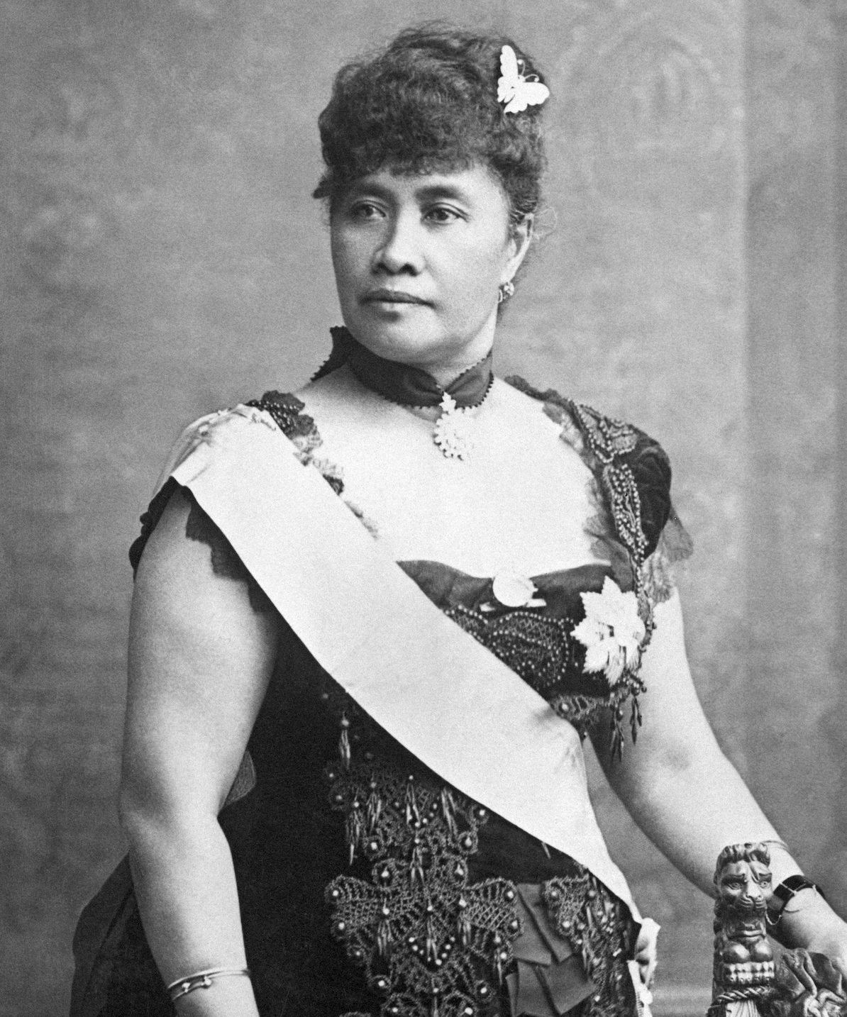
In 1895, Queen Liliʻuokalani spent nearly eight months imprisoned in an upstairs bedroom in Iolani Palace in Honolulu. She had been put there by American businessmen backed by the United States military who had overthrown the Hawaiian Kingdom, an internationally recognized sovereign nation.
She spent her days in confinement translating the creation story of the Hawaiian people into English, line by line.
She would never be allowed to rule over her people again. The U.S. annexed Hawaiʻi over the protests of the Native people, and the islands became a territory and then a state. But now the work of the imprisoned queen is resurfacing in the international debate over whether to mine the seabed for minerals that could accelerate the energy transition away from fossil fuels.
Queen Liliuokalani, the last royal leader of Hawaiʻi, in a photo from 1887.
Bettmann / Getty Images
Solomon Kahoʻohalahala, a Native Hawaiian activist from the island of Lānaʻi, has been pouring over the queen’s translation, known as the Kumulipo, and bringing it to the attention of state and international lawmakers to make the case that the ocean is sacred to Hawaiians and deep-sea mining would irreparably harm it.
“The ocean doesn’t know any boundaries. The fish and the animals don’t know boundaries,” Kahoʻohalahala said. “We are the people that have subsisted and we have lived here, so we need to protect it all.”
Locally, his message is resonating: On Monday, Hawai’i Gov. Josh Green signed into law a ban on seabed mining in the state’s surrounding waters, making Hawai’i the fourth state to do so following Oregon, Washington and California. The ban prevents any permits from being issued for extracting minerals within state waters. The new law comes on the heels of a letter a dozen members of Congress sent to President Joe Biden last month asking him to support a moratorium on deep-sea mineral extraction.
The mining of minerals like cobalt, which can be used to make electric-vehicle batteries, has the potential to jumpstart a multi-billion-dollar industry that could accelerate the green transition away from reliance on oil and gas. But opponents are concerned about the potential for irreparable harm to sea creatures that have spent millions of years untouched.
To Kahoʻohalahala, the ban in his home archipelago is meaningful, as are efforts to put pressure on the Biden administration. But the U.S. doesn’t have a seat at the International Seabed Authority because it hasn’t ratified the United Nations Convention on the Law of the Seas. And that’s where the most important negotiations are happening that could determine whether permits are granted to allow corporations to mine the high seas.
The agency hasn’t yet approved its agenda for this month’s gathering, but the stakes are high.
Member states are expected to vote on a new secretary-general, which features two candidates with far different views on the future of mining. The New York Times reported last week that the election is already embroiled in scandal amidst allegations of bribery for votes and similar corruption.
There’s also increasing interest in deep-sea mining from places like American Samoa. It’s possible that the agency could receive proposals this summer from companies and governments who want approval for their mining plans.
That’s why Kahoʻohalahala feels it’s urgent to ensure Indigenous peoples have a voice in any decision making. He wants the International Seabed Authority Council to establish a Committee on Intangible Underwater Cultural Heritage which can advise the Council on how mining proposals might affect Indigenous peoples’ cultural connection to the ocean.
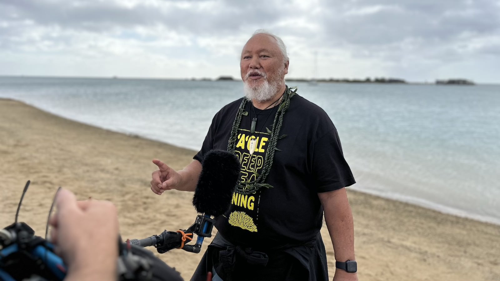
Solomon Kahoʻohalahala, a Native Hawaiian activist, speaks out against deep-sea mining during a press conference in Honolulu in December 2023.
Anita Hofschneider / Grist
“The colonial perspective and that of deep sea mining is that the deep sea is an area of vast voidness and there is nothing there. They have determined that this really belongs to no one,” he said. “No one had ever considered that the Indigenous people of Oceania have a connection and relationship to what they’re calling the high seas.”
Kahoʻohalahala grew up in a family of farmers and fishers on the Hawaiian island of Lānaʻi, and spent years working in local and state advocacy for Indigenous rights and conservation before starting to participate in international conservation and biodiversity meetings in the last decade.
Two and a half years ago, he heard about the International Seabed Mining Authority. He attended an agency meeting in Kingston as an observer representing Greenpeace. There he realized that the agency was considering permitting mining on the ocean floor in the Clarion-Clipperton Zone, about 500 miles south of Hawaiʻi.
Since then, he has become Hawaiʻi’s leading activist against seabed mining.
“My commitment is to make sure that we’re doing what is responsible for us to do as kupuna looking forward for the next several generations, 100 years from now,” he said, using the Hawaiian word for elders. “I hope that our great mo’opuna (grandchildren) will say our tutus (grandparents) were involved in caring for this space, and that is why we can still be here 100 years from now.”
Kahoʻohalahala thinks of Queen Liliʻuokalani often. He thought about her on Monday as he stood in the Hawaiʻi governor’s office, a stone throw from the palace where she was imprisoned.
“(I am) thankful that our Queen, in her darkest hours, at Iolani Palace took the time to translate this into English, to help us to be advocates of our own cultural connection, which ties us all to all ecosystems,” Kahoʻohalahala said.
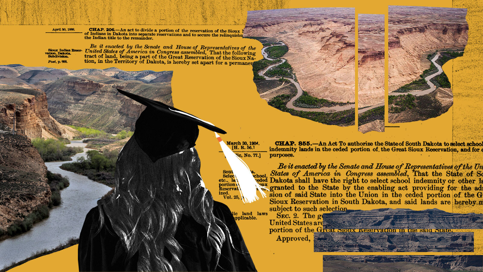
Skiing, hiking, and other outdoor recreational pastimes have lent Colorado a woodsy — and environmentally friendly — reputation. This image is at odds with the state’s first and biggest industry: mineral extraction. From 1858 to 2022, mineral extraction in Colorado has amounted to a $546 billion dollar industry. The state remains one of the leaders in coal and gold, but the state is also home to oil, natural gas, limestone, and helium mining.
Contrary to the carefree spirit of those outdoor activities that the state is known for, the growth of mining, and the development of its extractive practices, all have origins in the genocide and forced displacement of Indigenous peoples native to the region. A new report by a nonprofit organization called People of the Sacred Land traces the history of how state and federal officials have “systematically undermined Tribal sovereignty and Native self-governance through tactics like genocide and illegal land dispossession to exploit the wealth and resources of Tribal Nations.” The report, which results from a two-year study, also contends that tribes like the Arapaho and Cheyenne never gave up their mineral rights in Colorado and are entitled to compensation appropriate to how much land was stolen.
Rick Williams, who is Lakota and Cheyenne, is the executive director of People of the Sacred Land, and he said that the report shows how the history of Indigenous people in Colorado hasn’t been adequately understood. The three-part report is an attempt to correct the inadequate awareness and education. The second part of the report is a Historic Economic Loss Assessment, which offers a quantitative accounting of the economic impacts that American expansion into the territory has had on the Indigenous tribes.
“It has everything to do with the people living today, because it’s those people who are benefiting from the wealth of the land, the resources of the land, the water, the oil, the gas, the gold,” he said.
Colorado has made $1.9 trillion dollars from these dispossessed lands, which includes earnings from recreation, timber, mineral extraction, and real estate. The TREC commission thinks there should be some recognition, and compensation, to tribes for land rights they never consented to giving up.
Read Next
Starting in the late 18th century, a series of legislations established that settlers could not purchase land in the Colorado territory, but many settlers did so anyway, buying land from territorial governments and effectively excluding the tribes from the process. The report names Denver, Boulder, Colorado Springs, and Pueblo as illegally established on unceded Native lands. The United States was supposed to protect land belonging to tribes, but as settlers were drawn to the area via the gold rush, the United States failed to protect the land and eventually stopped trying, according to the report.
In the mid 1800s, tribes were often removed from their land under the threat of violence, or coerced into signing treaties under duress to make room for more settlers, who were interested in the newly established Colorado Territory. But the tribes were never fairly compensated.
Even if one is to accept the letter of such treaties, mineral rights were often not specified as part of what the tribes were ceding. Therefore, the commission argues, if a tribe didn’t specifically give up its mineral right, then the right remains with the tribes even after all these years into colonization. Furthermore, the TERC report argues that the financial injuries borne by the region’s tribes should be recalculated.
“Considering most contracts have recognized mineral and water rights unless specifically stated, they weren’t ceded,” Dallin Maybee, who is Northern Arapaho and a legal scholar and commissioner on the report, said. “It’s no secret that the wealth of the country was built on the back of natural resources extracted from Indigenous lands who were diminished as westward expansion occurred.”
Colorado’s Department of Natural Resources Chris Arend said in response to the findings of the report, “The state of Colorado is committed to working with Tribal Nations to protect their lands, and further consulting with the Tribal governments on these comprehensive issues.”
Colorado’s long history of mining has contributed to deforestation and water and air pollution. “Mining is an inherently destructive and invasive process, and it continues to impact the surrounding land, water, atmosphere, flora, and fauna long after sites have been abandoned.” the report said. Even unused mines still pose a danger to the environment. Currently there are 23,000 abandoned mines that impair the water quality of streams in Colorado.
Clint Carroll, who is Cherokee, is an environmental researcher and professor of Indigenous Studies at the University of Colorado Boulder. He says the report outlines steps Colorado and these settler communities can take to help Indigenous communities today.
“If you can’t name and point to it in this way, decolonization becomes somewhat a utopian dream,” he says. He mentioned that he plans on assigning reading from the TREC report in his Indigenous Environmental Issues course. “People are missing a huge part of the picture. And this is a document that helps pave the way for non-Native people to understand.”
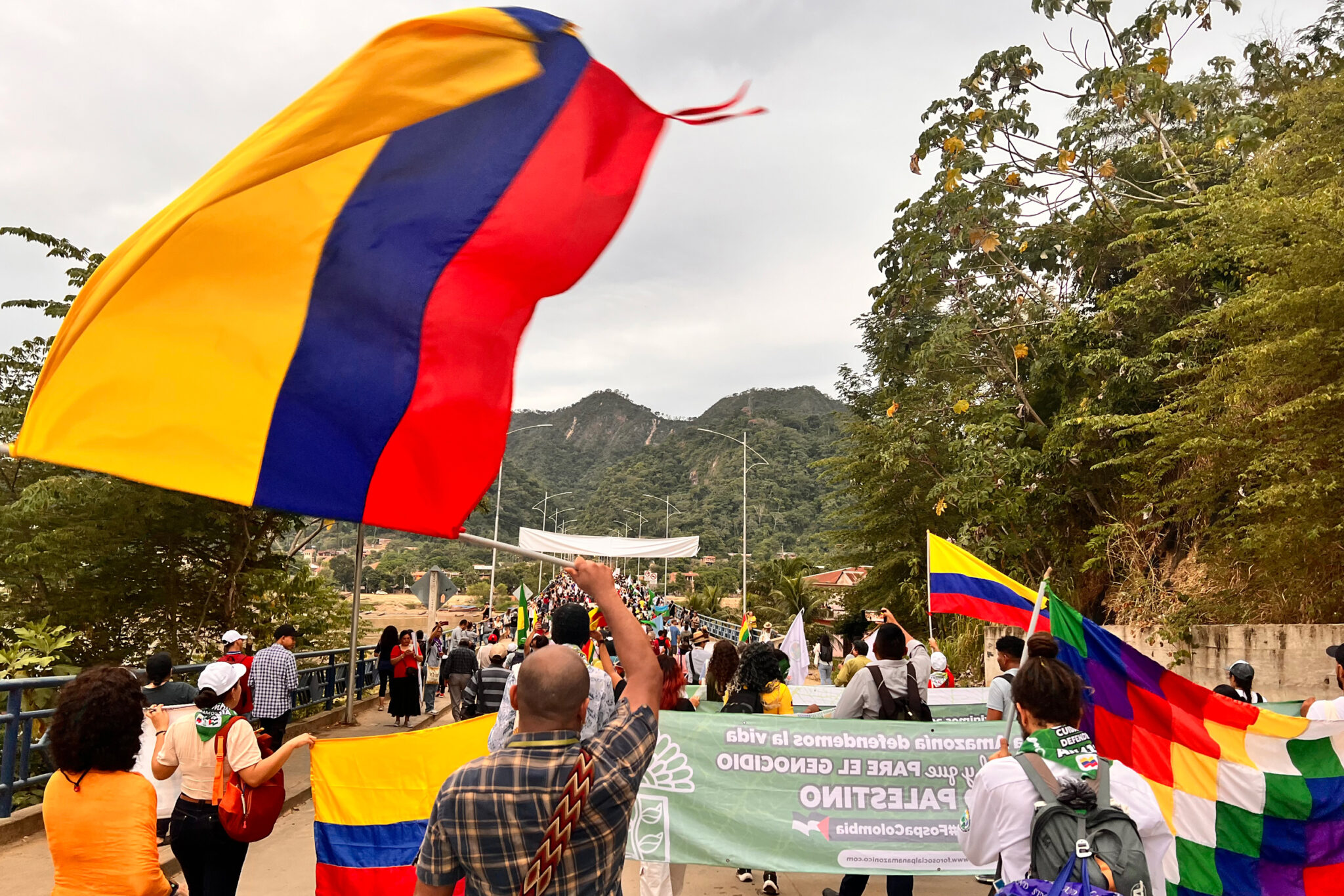
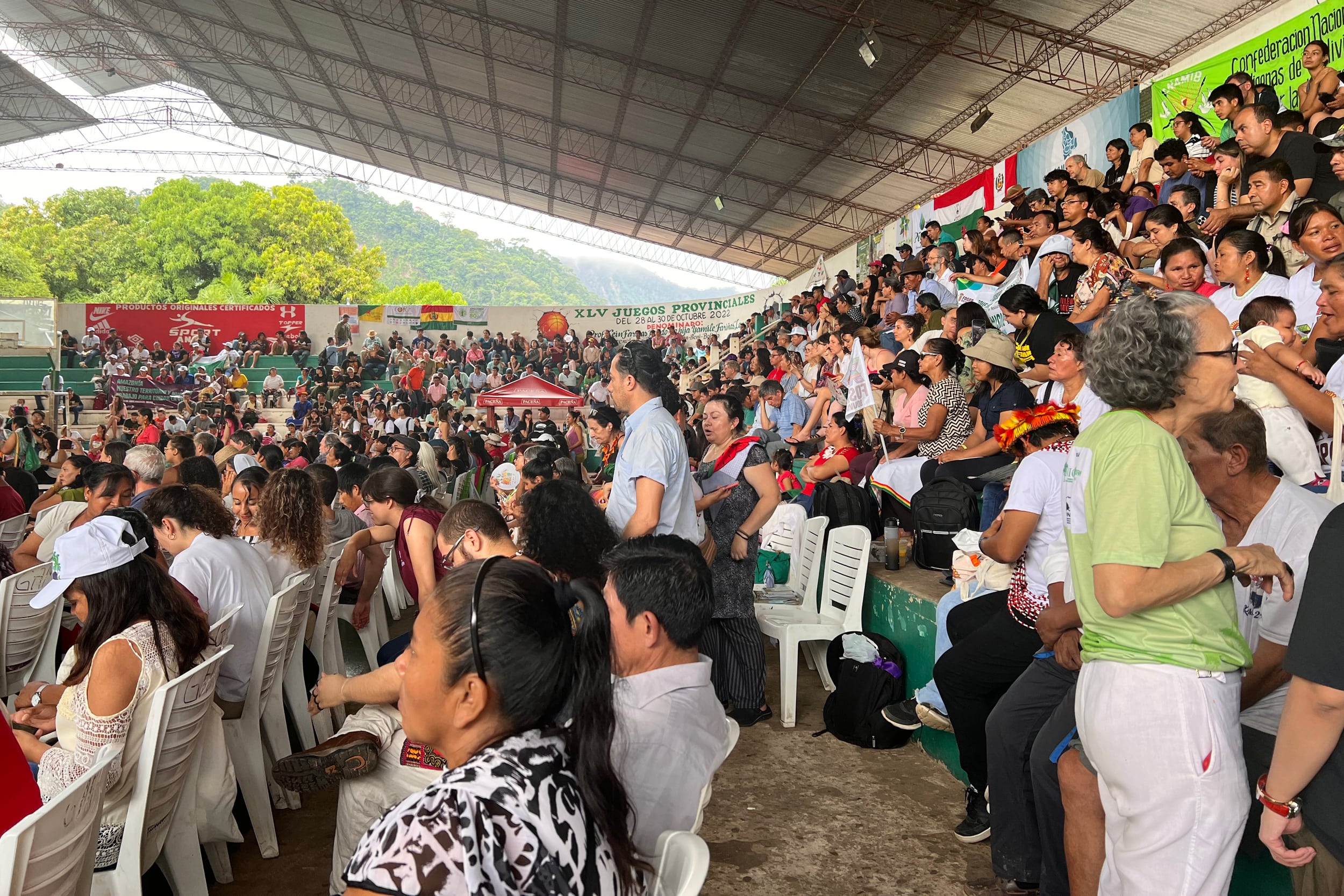
Beneath a setting sun, marchers clad in feathered headdresses and hand woven clothing streamed across the Alto Beni River bridge on a muggy June evening, calling out:
“Agua si! Minería no!”
“Viva Amazonia!”
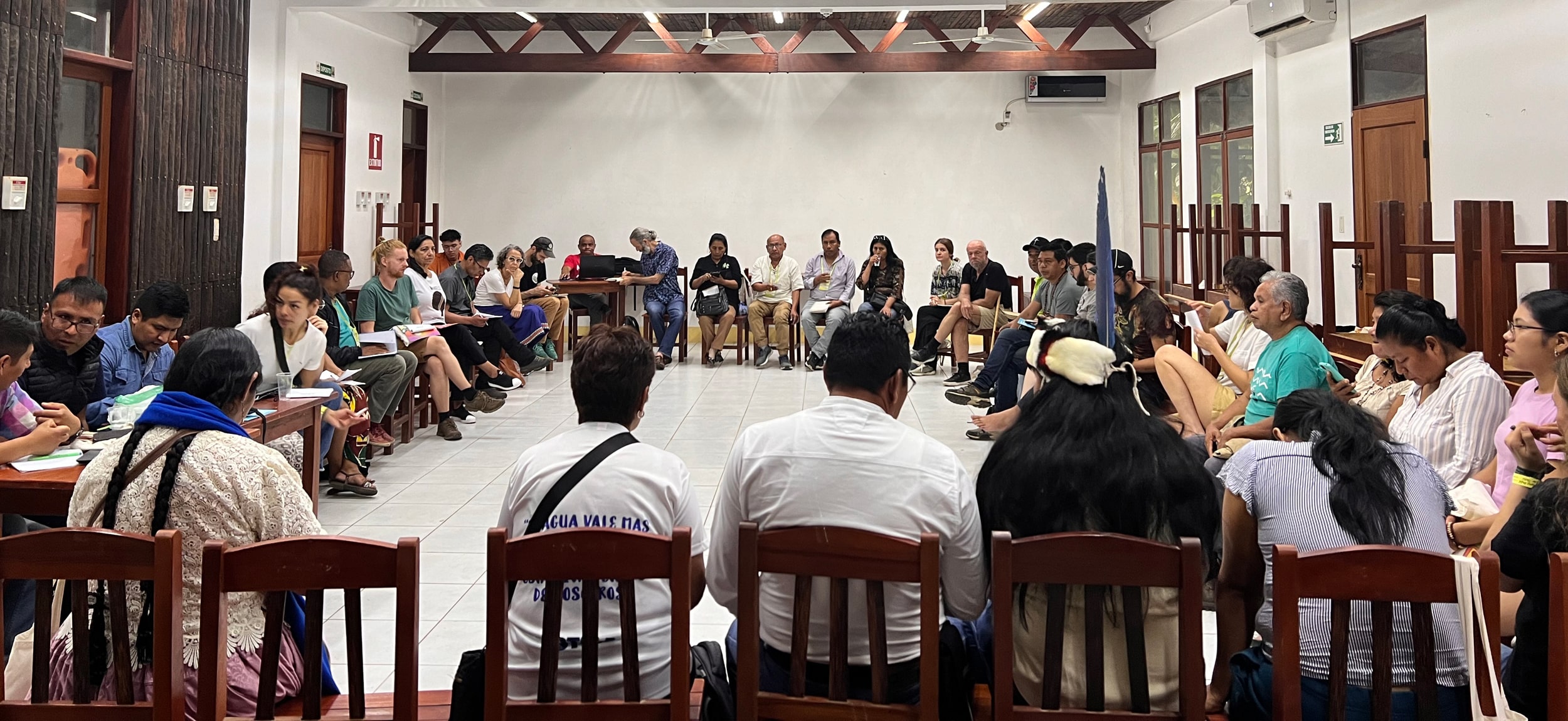
The march marked the opening of a four-day gathering known as the Pan-Amazon Social Forum (FOSPA), a semi-annual incubator where activists and leaders from Indigenous, Afro-descendant and other land-based communities exchange ideas for defending nature and the people of the Amazon rainforest.
Attendees, young and old, brown, Black and white, chanting “Water, yes! Mining no!” clasped signs representing dozens of organizations and causes, from “Women in the Northern Amazon” to “Nunca Más Un Mundo Sin Nosotros,” or Never Again a World Without Us.
For the 1,400 who descended on this small, bucolic Amazonian town, most of whom hail from Indigenous and other local communities across the nine Amazonian countries—Brazil, Peru, Colombia, Venezuela, Ecuador, Bolivia, Guyana, Suriname and French Guiana—the meeting was a welcome change from the formal United Nations’ Conference of the Parties (COPs). COPs on climate change and biodiversity, which are dominated by government delegations, have been criticized for being captured by industry lobbyists.
Amazonian marchers wave the Colombian flag (left)and Bolivian Aimara wiphala flag (right) during FOSPA.
Katie Surma/Inside Climate News
“FOSPA is one of the few spaces for us to have our own dialogues,” said Vanuza Abacatal, the leader of a 314-year-old Quilombola community in Pará, Brazil. Abacatal’s community has struggled to defend its autonomy and maintain its way of life in the face of an encroaching agricultural frontier, mining and deforestation.
Beyond feeling that international negotiations are disconnected from their lives, the marchers here in Rurrenabaque and San Buenaventura, the small Bolivian towns hosting the conference, say governmental climate talks have failed. They cite the Paris Agreement’s target to limit global warming to 1.5 degrees Celsius above pre-industrial levels.
In 2023, global average temperatures breached 1.5 C for 12 months in a row, the European climate service Copernicus announced in February, and the world’s current warming trajectory will put global temperature rise at 2.8 degrees Celsius by 2100. Scientists say that amount of warming will be disastrous for the Amazon. Current levels of warming are already changing the forest’s hydrological cycles, drying it out and making it more susceptible to fire. As more forest is lost, more carbon dioxide is released into the atmosphere, worsening global warming in a reinforcing cycle.
Climate change is just one of several human-driven forces that has, over the last century, caused about 20 percent of the Amazon to be lost and an even larger portion to be degraded. Agriculture, cattle rearing, mining, oil extraction and logging are all contributing factors. Loss of the Amazon, which is happening at a pace of roughly four soccer fields per minute, has already reached a point where some portions of the forest can no longer regenerate and have become grasslands. Directly affected are 47 million people living in the Amazon region who depend on the forest for their livelihoods, fresh water and other resources.
The marchers here at FOSPA are witnessing the Amazon’s destruction first hand. “We are being suffocated by large enterprises,” Abacatal said.
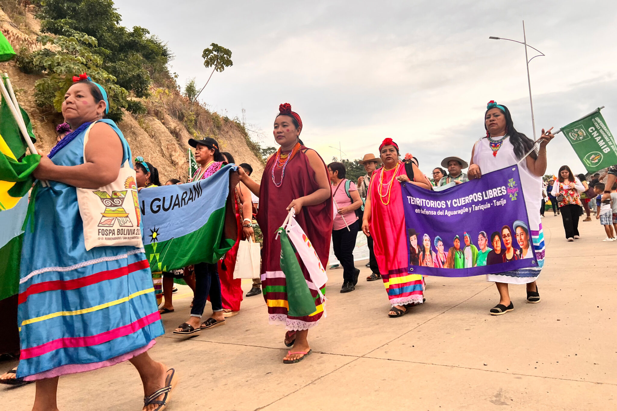
Indigenous women march with a sign that reads “Free Territories and Bodies, in defense of Aguarague and Tariquia Tarija” during FOSPA on June 12.
Katie Surma/Inside Climate News
She and other Amazonian inhabitants are simultaneously the most impacted by the loss of the forest and, they have long argued, best positioned to safeguard what remains of it. Their peoples’ centuries of experience living within the forest has endowed them with valuable knowledge about it.
Research is quickly catching up to them, with study after study confirming that Indigenous communities with secure land tenure have the best conservation outcomes, even when located near urban areas. And, increasingly, scientists are partnering with some Indigenous and local communities to identify key biodiversity hotspots and prioritize those areas, like animal reproduction and migration zones, for conservation.
With those bona fides, participants said they are ramping up their ambitions since the last FOSPA, held in 2022 in Belem, Brazil. That conference, like the nine before it dating to 2002, generated an accounting of the threats facing the forest and called on governments to do more to protect it.
But in the intervening two years since Belem, millions of acres of the Amazon have been cleared, burned or degraded; threats to inhabitants like mining and drug trafficking grew; and governmental talks in a separate conference in Belem in 2023 among the leaders of the nine Amazonian nations concluded without an agreement on stopping illegal deforestation by 2030. Instead, that Brazil-led summit ended with a vague text promising to cooperate on staunching illegal deforestation and promoting sustainable development.
So, with the stakes as high as ever, FOSPA attendees in Rurrenabaque had a deadline in sight: Within four days, they had to deliver a written prescription for what the world must do to prevent “climate and ecological collapse.”
‘Original people without our land are nothing’
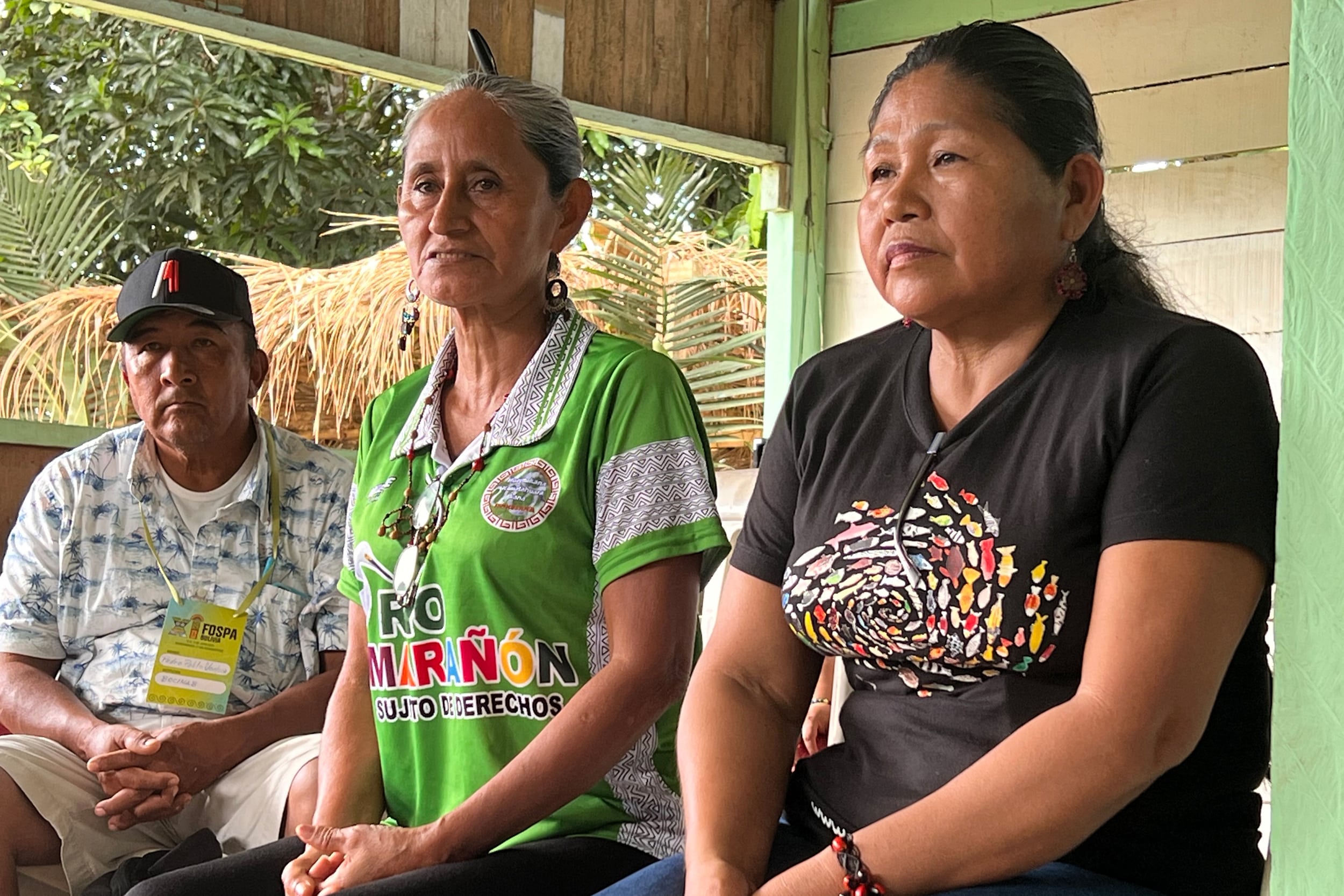
On the second day of the conference, in an Indigenous community outside Rurrenabaque, dozens of people focused their attention on Mari Luz and Emilsen Flores, Peruvian Kukama leaders. They were gathered inside a rainforest pavilion where nearly everyone had broken out into a sweat in the tropical heat. The pavilion had been set up with white plastic chairs, though some local men remained standing outside, their heads poking over the structure’s walls.
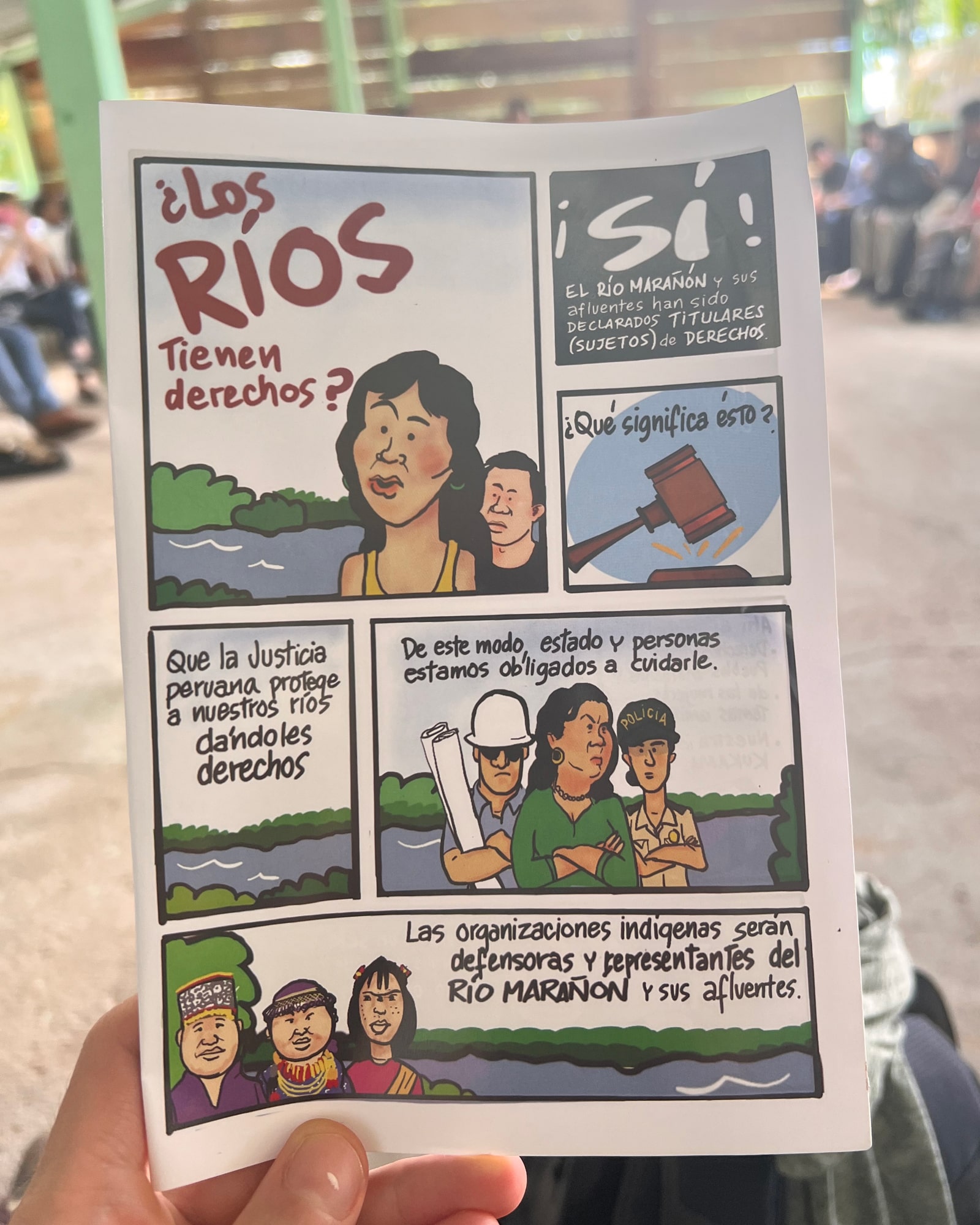
Luz, speaking in a gentle voice, unspooled how she, Flores and other Kukama women won a historic Peruvian court ruling in March, establishing that the heavily polluted Marañon River is a living being with inherent rights.
It was a major victory in the rights of nature movement, which aims to garner legal recognition of the rights of rivers, forests and whole ecosystems to exist. The movement is largely seen as translating into law the worldviews of Indigenous peoples.
Emilsen Flores (center) and Mari Luz (right), Peruvian Kukama leaders, speak to attendees of the FOSPA conference on June 13 in Bella Altura, Bolivia.
Katie Surma/Inside Climate News
As Luz spoke, glasses of fresh papaya juice and chicha, a customary drink made from fermented corn, were passed around to the mix of conference attendees and Tacana people from the host community, Bella Altura.
She began in 2000, when environmental organizations from Europe came to meet with locals about the vast oil-related pollution in the Loreto region of Peru, which had been ongoing since 1974. For Luz and the others, who depended on the Marañon River for food, water and transportation, the contamination had been catastrophic.
During the male-dominated meetings, Luz and other women had sat quietly, she explained, listening to the discussion about human rights. But later, the women met amongst themselves to discuss what they had heard. Luz recalled: “We women said, ‘We’re supposed to have rights. How can oil projects be forced on us when we don’t want them?’”
The women quietly formed their own federation, the Huaynakana Kamatahuara kana, meaning “working women,” she said, with the aim of protecting their environment, rights and culture. And then, in what would prove to be a propitious encounter, Luz was introduced to environmental lawyers at the Peru-based Institute of Legal Defense. She wanted to know whether the Marañon River, like her, had rights.
“Do rivers have rights?” reads an illustration depicting the story of the Peruvian Kukama women who won a landmark victory in March establishing that the heavily polluted Marañon River is a living being with inherent rights.
Katie Surma/Inside Climate News
A dialogue ensued, with Luz educating the lawyers about her peoples’ view of the world. Nature is alive, she told them, and every being has a spirit. Those spirits live in the mountains and beneath the river, maintaining all the life within it.
The lawyers, in turn, told Luz and the Kukama women’s federation about the burgeoning body of law known as the “rights of nature.”
Thus began a 10-year partnership that culminated four months ago in a trial court ruling in favor of the Marañon River’s rights. Luz was blunt about the difficulties throughout. She and her family had been threatened with violence. “To be famous is very dangerous,” she said. To attend court hearings, she had to leave her rural home in the middle of the night, traveling by motorized canoe for hours, often in drenching rain.
At times, she had to sell off chickens to pay for fuel for the boat trips. Government officials demeaned her and fined her 100,000 Peruvian Soles (about $26,000 USD), she said, for her advocacy. Men in her village denigrated her. “There is a lot of machismo; they treat women like objects,” she said.
Luz, who became more animated the longer she talked, said that over the years, she had invited men in her village to the women’s federation meetings, swaying around 70 to 80 percent of them over to the women’s cause. “We’ve grown from the bottom,” she said.
The “just energy transition” working group at FOSPA discussed issues ranging from access to energy to carbon credit schemes and ecosystem restoration.
Katie Surma/Inside Climate News
Across the pavilion from Luz and Flores, a half dozen teenage Tacana girls watched the women with focused concentration. Other people in the crowd, including members of Brazilian and Bolivian Indigenous communities, took notes.
Luz emphasized that the Kukama women are continuing to fight—the government and other defendants have appealed the trial court ruling, and those appeals are pending. Even if they win on appeal, enforcing the river’s rights to exist, flow and be free from pollution will not be easy, she said.
In the crowd, heads nodded. Like Luz, many of the people gathered there had lost, or never had, faith that their state legal systems would protect them. Luz’s story emphasized what most already knew: No one was coming to save them. Real solutions, they said in a question and answer session following Luz’s talk, could only come through their own struggles, experiences and efforts.
One audience member asked Luz why she continued fighting.
“Original people without our land are nothing,” she said. “Now that we know our rights and nature’s rights, we need to claim them.”
A just transition
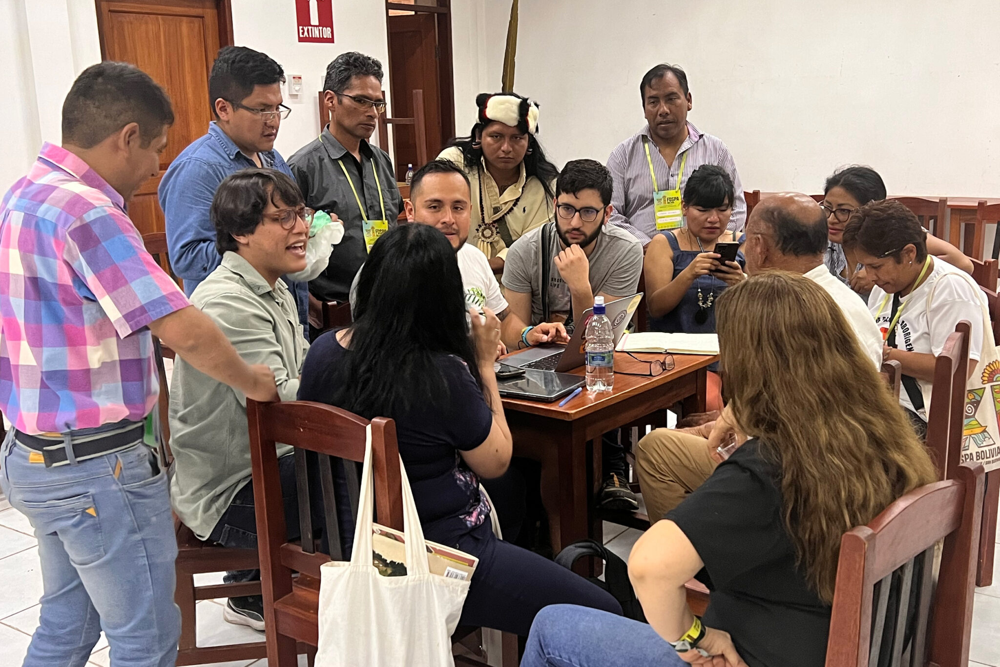
A few miles away, in the town of San Buenaventura, attendees of the conference’s “just energy transition” group arrived via motorized tuk tuks at a meeting hall at the end of a dirt road.
After more than a year of meeting over the internet, the group was now drilling down on a final list of proposals for what a transition away from fossil fuels ought to look like.
With a microphone passed around for three-minute orations, the session had faint echoes of a U.N. summit. Except here there were no three-piece suits or backroom dealmaking by representatives from the fossil fuel, agriculture or mining industries.
Members of the “just energy transition” group draft their findings following four-days of deliberations on the issues.
Katie Surma/Inside Climate News
Rather, participants’ policy proposals were braided together with their own lived experience with illegal mining in the Bolivian Amazon, or decades of oil pollution in Ecuador’s Oriente.
There was broad consensus that the lack of electric power access for local communities throughout the Amazon was a major problem that had to be solved. In some cases, transmission lines had been installed adjacent to, or across from, forest communities but had never been connected. One woman told the group that her community in Brazil has no phone or internet. Instead, they have to communicate with an old-school radio. “If people don’t know what’s happening, they can’t participate in the debate about it,” she said.
Without energy, people also cannot access education, obtain health services or build sustainable economies, J. Gadir Lavadenz Lamadrid, a La Paz-based campaign coordinator for Global Forests Coalition, told the gathering. That makes communities vulnerable when mining or oil companies approach them to initiate projects on, or affecting, community land, he said.
Indeed, throughout Latin America, which produces a substantial share of the world’s fossil fuels, hydroelectric power and minerals used in zero-carbon technologies, 17 million people lack access to electricity, according to the International Energy Agency.
The region is also one of the most economically unequal parts of the world, making energy affordability part of the problem—even for communities enduring the brunt of the impacts from energy supply chains.
As the microphone was passed around the room, a woman from Argentina’s lithium producing region said her community’s water and soil have been contaminated from lithium brine operations. But those affected, she said, have never been compensated for the destruction, which has not been remediated. When the community demanded that the provincial government provide them with consistent renewable energy, they were told they had to purchase batteries to store it. “We don’t have the money to do that,” she said.
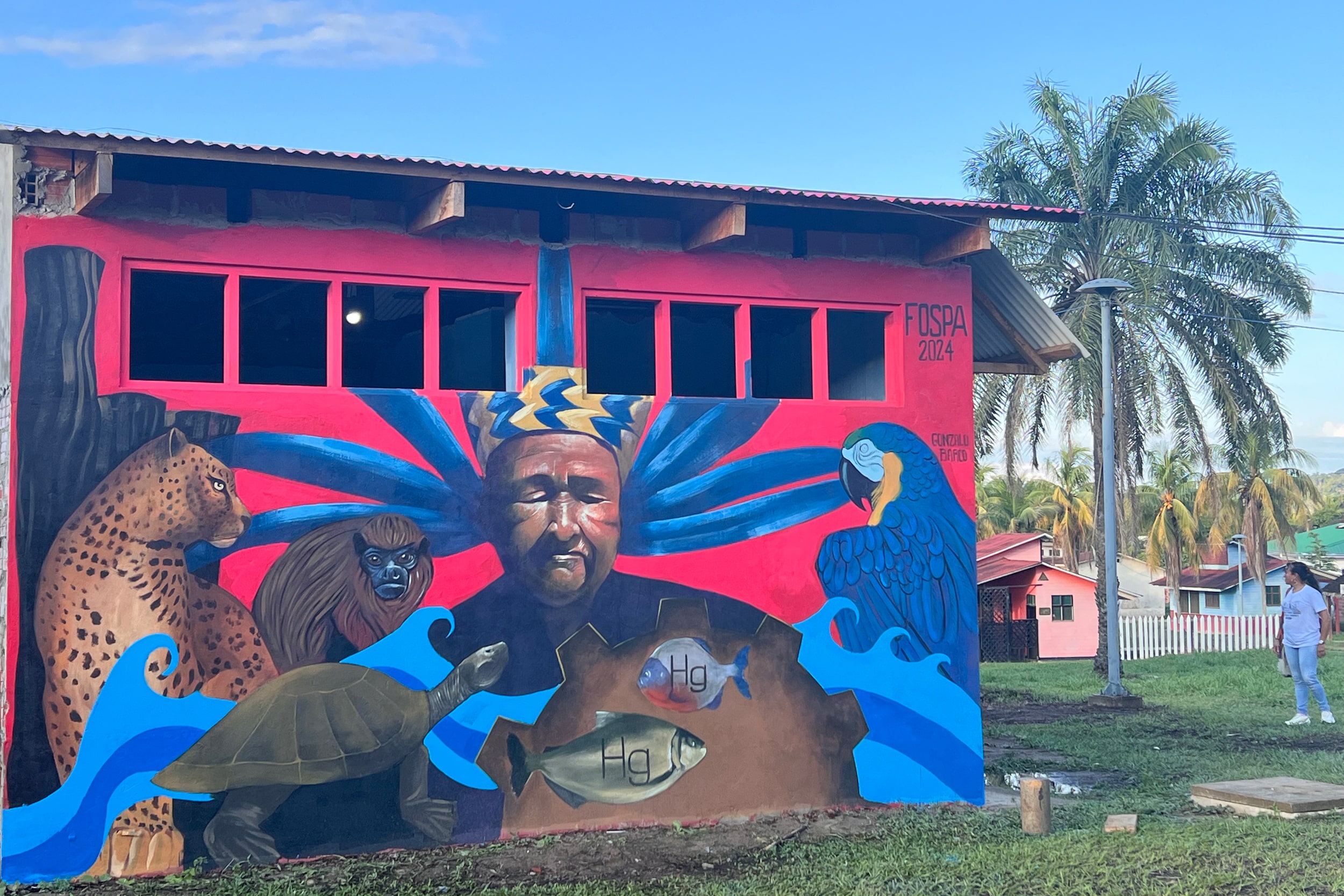
A mural in San Buenaventura, Bolivia depicts an Indigenous man and Amazonian wildlife, including fish overlaid with the abbreviation “Hg” for mercury on the periodic table. Studies show rivers in the Bolivian Amazon are riddled with mercury poisoning, linked to illegal gold mining operations in the region.
Katie Surma/Inside Climate News
The discussion moved on to a blistering criticism of the overconsumption habits of people living in wealthy countries, including the idea that the climate crisis can be solved by individuals purchasing electric vehicles. The group, some of whom live in the shadow of mining operations for zero-carbon technology inputs, called for more investment in public transport and a cultural shift away from wealthy countries’ consumer-driven culture.
There was also broad consensus that carbon and biodiversity offsets and credits were “false solutions” that come at the Amazonian communities’ expense. Indigenous and traditional groups in the forest, numerous speakers said, are rarely consulted about such projects.
Just days before FOSPA kicked off, Brazilian police cracked down on a scheme that allegedly provided carbon offsets to large Western corporations for rainforest preservation despite continued illegal logging. The conferees in San Buenaventura called for the funding and financing behind offset projects to instead be directed toward Indigenous and other local communities that are living sustainably in the forest.
Across 16 working groups at the conference, the issues debated were, unlike the U.N.’s annual climate COPs, rooted in the proposition of what is best for the Earth and, specifically, the Amazonian ecosystem. Ending $7 trillion in annual subsidies to extractive industries. Expanding agroecology and ecotourism. Enforcing Indigenous land rights and the right to free, prior and informed consent. Protecting environmental defenders, who are increasingly threatened, imprisoned, assaulted and killed for resisting development and extractive activities.
Since 2014, nearly 300 environmental defenders have been killed in the Amazon, a statistic widely considered to be an undercount since the violence often takes place in remote areas. For many at FOSPA, the violence inflicted on people defending the forest is indistinguishable from the ravaging of the rainforest itself: “We are nature, defending nature,” was a common refrain.
There were also big new ideas hatched, like a detailed proposal for an Amazon-Andean treaty aimed at preserving the region’s hydrological cycles, recognizing water bodies as rights-bearing entities and creating a Permanent Assembly of Andean and Amazonian people to act as guardians for the water systems.
The proposal includes a description of the region’s water cycle, which begins high in Andean glaciers, flows down through rivers, cycling through Amazonian flora and fauna, and eventually moves out into the Atlantic Ocean. When one part of the cycle is altered, the entire system is affected, speakers explained: When the Amazon burns, ash from the fires lands high in the Andes, turning glaciers black, drawing in more heat and accelerating their melt rates. Loss of Andean glaciers will have downstream impacts, including the ability of millions of people to access drinking water, they said. Climate change is also affecting the region’s hydrological cycle, with droughts and heat waves stressing water sources.
Pablo Solon, Bolivia’s former U.N. ambassador and one of the conference’s organizers, said the proposed treaty is the first water-focused treaty that is non-anthropocentric, meaning that it is centered on what is in the best interest of the hydrological cycle rather than only addressing human interests.
“This is the beginning of a new kind of multilateralism,” said Solon, who in 2010 played a central role in launching a global rights of nature movement that now has pushed through laws in over 30 countries.
‘Without the Amazon there is no solution to the climate crisis’
For the last day of FOSPA, conferees packed into Rurrenabaque’s colosseum stadium against a backdrop of misty rainforest draped over mountainous cliffs.
“Without the Amazon there is no solution to the climate crisis. Without a solution to the global climate crisis, it will not be possible to save the Amazon,” the document began.
Representatives of communities from across the Amazon rainforest gather inside the “Colosseo” in Rurrenabaque, Bolivia on June 15 for the closing of FOSPA.
Katie Surma/Inside Climate News
The communique called for the end of new investments in fossil fuel projects in the Amazon region and listed eight steps to end deforestation, including the demarcation and titling of Indigenous peoples’ lands and the sanctioning of institutions that finance activities causing deforestation.
With many in the stands filming the stage with their cell phones, representatives from three Ecuadorian Indigenous groups were asked to consider hosting the next FOSPA conference.
The request was made largely on the basis of Ecuador’s landmark 2023 referendums, where 59 and 68 percent of voters, respectively, voted to end oil operations in a portion of Yasuni National Park and mining operations in the Chaco Andino cloud forest outside of Quito. Since the vote, Ecuador’s government has suggested that it may postpone compliance with the Yasuni referendum on national security grounds. Whether the country complies with the referendum is largely seen as a litmus test for the viability of plebiscites aimed at keeping fossil fuels in the ground. At FOSPA, participants batted around the idea of using similar tactics to block Brazil from pursuing controversial oil operations at the mouth of the Amazon River.
The Yasuni and Chaco referendums are Amazon-grown tactics that participants aim to begin exporting. Pepe Manuyama, an Indigenous leader based in Iquitos, Peru, told other attendees they needed to lean into the political world of their home countries with the aim of promoting globally the Amazonian worldview—that nature is a living being, that it is possible for humans to thrive without unsustainably exploiting the Earth, and that humans and nature are interdependent.
“We need to build a new world,” he said. “From the Amazon, we can offer a different paradigm.”
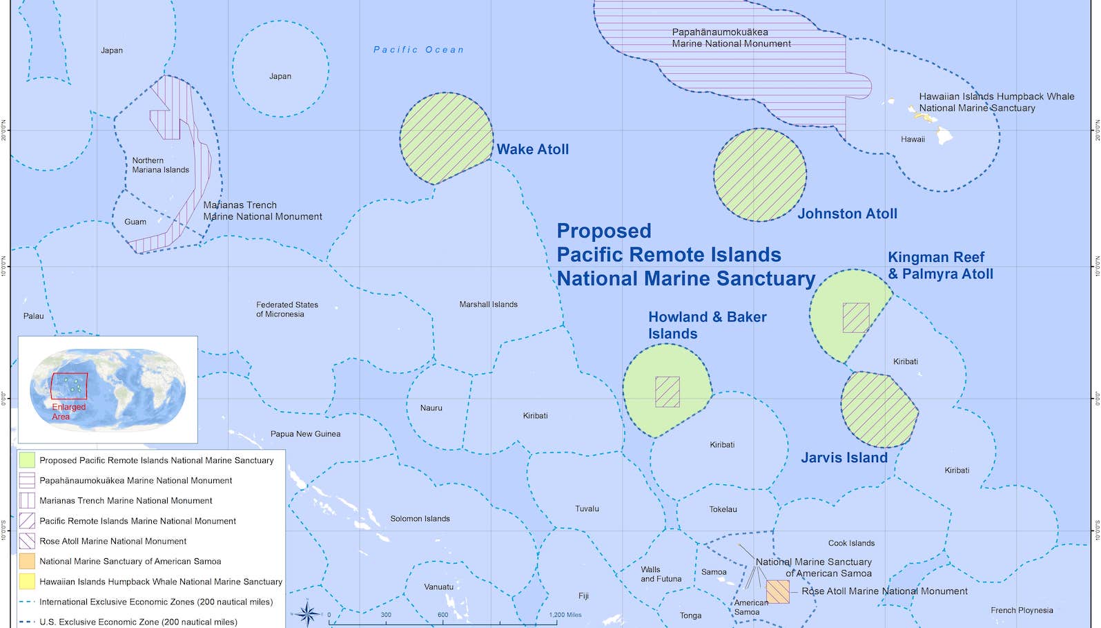
President Biden’s administration wants to create the largest non-contiguous protected ocean area in the world, but a new paper says the effort is failing to take into account the rights and perspectives of the Indigenous peoples most affected by the change.
The Pacific Remote Islands Marine National Monument was established in 2009 and currently preserves nearly half a million square miles of ocean surrounding seven islands in the central and western Pacific. The Biden administration is seeking to strengthen environmental protections by overlaying and expanding the area of protection up to 770,000 square miles and designating it as a national marine sanctuary. The monument already bans commercial resource extraction like deep-sea mining, but the proposed sanctuary would both expand the protected waters and give the whole area an additional layer of federal protection.
The expansion would also make a dent in the Biden administration’s goal to conserve 30 percent of the country’s land and waters by 2030.
Map of the proposed Pacific Remote Islands National Marine Sanctuary.
Courtesy of NOAA
However, according to Angelo Villagomez and Steven Manaʻoakamai Johnson, authors of the peer-reviewed article in Environmental Justice, the Biden administration has privileged Native Hawaiian perspectives (who are supportive of the expansion, which does not extend to the archipelago) over those of other Indigenous Pacific Islanders, namely Micronesians and Samoans, who have less political power in the U.S. system and have voiced more concerns about the proposal.
“Anti-Micronesian bias and colonialism are harming efforts to protect and manage waters surrounding U.S. overseas territories in the Pacific Islands,” the authors wrote. “The proposal is problematic because it has failed to meaningfully include the Indigenous people who live closest to the region and who have the strongest historical and cultural ties to the islands — Micronesians and Samoans.”
Villagomez, a senior fellow at the Center for American Progress who is Chamorro and grew up on the Mariana Islands, has been advocating for ocean-protected areas for more than 15 years. When he began this work, back in 2007, Villagomez sought to organize support in the Commonwealth of the Northern Mariana Islands for the Marianas Trench National Marine Monument, which conserves nearly 100,000 square miles of water in the Marianas archipelago. Although the proposal faced pushback from locals who were concerned that the move infringed on Indigenous sovereignty, Villagomez thought the monument would not only help the planet but also bring federal jobs to the territory. He was in the room celebrating when then-President George W. Bush signed the monument into existence in 2009, hailed as a major environmental achievement.
For years afterward, Villagomez watched as government jobs for the monument were concentrated in Hawaiʻi. The office was located in Honolulu, thousands of miles away from the monument. Research vessels were being outfitted out of Honolulu and staffed with people who were from Hawaiʻi and other states. It was disappointing to see that these benefits weren’t helping the people of the Northern Marianas, which has a much more fragile economy. After all, he had seen how the 2006 Papahānaumokuākea National Marine Monument in the northern Hawaiian islands had given Hawaiʻi a boost of prestige and research funding.
“We were working under the assumption that [the Marianas monument] would operate like [the one in] Hawaiʻi,” Villagomez said. “But the difference is Hawaiʻi has two senators, and they have representation in the House of Representatives, and they can vote for president. And we just don’t have the political power to bring the dollars to our islands the way that Hawaiʻi does.”
Only recently has an office for the Marianas Trench monument opened in the Commonwealth. And just last month — 15 years after monument designation — the Interior Department released a proposed management plan for the Marianas Trench monument. Villagomez thinks the delays reflect a broader disregard for the territories that he’s seeing unfold again in the Pacific Remote Islands sanctuary designation effort.
“The process of colonization doesn’t only play out with the colonizer and the colonized, but it also plays out in relationships between colonized people,” said Steven Manaʻoakamai Johnson, Villagomez’s co-author who is an assistant professor of natural resources and the environment at Cornell University. “In this case, what we’re trying to highlight is that the Hawaiian perspective and the Hawaiian voice is being privileged, above that of the Micronesian and Samoan voice.”
For instance, the official community group advising government agencies about the monument includes a designated Native Hawaiian representative but not an equivalent role for other Indigenous peoples, Villagomez and Johnson wrote.
Similarly, in documents describing the cultural importance of the islands, advocates for the marine sanctuary often describe the sacrifices of Native Hawaiians who lived on Howland, Baker, and Jarvis Islands during World War II, and ignore the comparable sacrifices of Indigenous Chamorros killed on Wake Island and the fact that most of the islands within the monument’s coverage are part of the Micronesian region, Villagomez and Johnson wrote.
Sarah Marquis at the National Oceanic and Atmospheric Administration said the agency plans to release a draft plan for the sanctuary designation later this year and will accept further public input on the proposal then. “We cannot comment on specific papers or articles at this stage of designation,” she said.
“It’s really important when we are critiquing frameworks that we feel like do not support our communities and our perspectives that we also highlight people, organizations, and communities that are working in that space to make those changes,” Lewis said.
Read Next
Villagomez said a major impetus for releasing the paper is the importance of Pacific territories to the U.S.’s ocean conservation goals: 29 percent of the country’s ocean territory surrounds Guam, American Samoa, and the Commonwealth of the Northern Mariana Islands, and 99 percent of the country’s protected ocean areas are in the Pacific region. Villagomez said he would like to see the territories accrue benefits from those protected areas, such as jobs and funding, but said sometimes they can’t even get their own people on the boats that explore those waters.
In American Samoa, political leaders have long opposed monuments that restrict commercial fishing. Even though conservation supporters point to a recent study that shows relatively few ships that dock in Pago Pago, its primary port, actually fish in the proposed Pacific Remote Islands sanctuary area, fears about economic harm persist. These concerns are particularly resonant when the islands’ struggling economies continue to fuel major outmigration and make it difficult for territories to provide essential medical care for their residents.
In the Northern Mariana Islands, commercial fishing is not a major industry, but critics of the marine monuments have argued that closing off large portions of the ocean to potential economic activity violates their right to Indigenous economic self-determination and is especially egregious when those same areas remain open to U.S. military undersea sonar training and explosive testing.
“Our already disadvantaged and marginalized communities carry a disproportionate burden for meeting national conservation goals,” the governors of American Samoa, Northern Mariana Islands, and Guam wrote in a joint letter to Biden last year.
Villagomez and Johnson both support ocean conservation but argue that any marine sanctuary designation should include dedicated funding for the affected territories and peoples, and urge NOAA to create such a fund.
“It’s the territories who are living with the decisions,” Villagomez said. “But it’s people in Washington D.C. and Honolulu who are forcing the territories to carry these burdens for the rest of the country.”
After a decade of work, the Tule River Tribe has released nine beavers into the nation’s reservation in the foothills of California’s southern Sierra Nevada mountains. The beavers are expected to make the landscape more fire and drought resistant. Beaver dams trap water in pools, making the flow of water slower so the surrounding ecosystem can reap the benefits of the moisture while making it more difficult for forest fires to start. They can also help a forest heal after a fire by rehydrating the area.
“We’ve been through numerous droughts over the years,” Kenneth McDarmet said, who is a Tule River tribal member and former councilman. “It’s going to be wonderful to watch them do their thing.”
Around 80 percent of the Tule River Reservation’s drinking water comes from the Tule watershed. Because the area is so important for the health of the community, the tribe has been preparing the area since 2014, building man-made dams to help the new beavers adapt more quickly.
Temperatures worldwide are expected to get hotter, increasing drought and creating conditions that make wildfires bigger and more deadly. In California, some of the worst wildfires on record have happened in the last five years partly due to drought. In 2020, three fires burned almost a million acres in the Sierra Nevada Forest, and in 2021 a wildfire burned an additional 1.5 million acres. Bringing beavers back may offer a break.
Prior to colonization, the North American beaver population was estimated to be around 200 million. But in the 1800’s, beavers were hunted for their pelts by settlers, decimating the population, while farmers and landowners viewed — and still view them — as pests. Today, the beaver population is estimated to be about 12 million.
But in recent years there has been a growing interest in traditional ecological knowledge from tribes, and the beaver has become celebrated as an ecological engineer.
In 2022, the California Department of Fish and Wildlife, or CDFW, secured funding for the Beaver Restoration Program, a program designed to restore the beaver population and support conservation efforts. In 2023, the CDFW recognized beavers as a keystone species, an animal that affects other animals on the landscape like bison or bees, and thus influences the ecosystem in major ways. Their absence typically has negative effects on the landscape and its interconnected ecosystems.
Today, the CDFW program partners with tribes, non-profit organizations, land-owners, and state and federal entities to restore beaver populations and habitats in an effort to improve climate change, drought, and wildfire resilience in California.
“We expect better habitat conditions for native critters on the land,” said Krysten Kallum, a public information officer with the CDFW. “It creates a refuge for plants and wildlife.”
More water means more plants that can attract other types of animals to the area. The CDFW expects to see better habitat development for amphibians like the western pond turtles, southern mountain yellow-legged frogs, and southwestern willow flycatchers, which will help increase biodiversity.
McDarment, of Tule River, said that tribal pictographs show beavers living in the area, and it’s good to see them here again.
“My hope is to have beaver throughout the reservation,” he said.
After decades of advocacy, the Mille Lacs Band of Ojibwe will see 18 acres of land returned to them by the state of Minnesota. The move comes after lawmakers passed legislation last month to formally return state trust lands inside the boundaries of the Mille Lacs Band’s reservation.
Minnesota’s returning of Indigenous land is part of a much broader global landback movement that has been gaining momentum in part due to studies that show Indigenous guardianship leads to more effective ecological outcomes. As conserving biodiversity grows more critical amid rising global temperatures, Indigenous self-determination and traditions of relating to land and waters are increasingly recognized as vital climate solutions.
“This is a great opportunity for us as the Mille Lacs Band to preserve that land in a way that is respectful of nature,” said Kelly Applegate, commissioner of natural resources at the Mille Lacs Band of Ojibwe. He said the land transfer is expected to be complete over the next month. “Whatever we do, it’ll be in a lens of environmental protection.”
The Mille Lacs’ lands in question are known as state trust lands. These trust lands, established at statehood, are grants of land from the federal government primarily created to support education and are found across the western United States. On the Mille Lacs reservation, those 18 acres represent only a fraction of the 2.5 million acres of state trust lands across Minnesota, including nearly 344,000 acres inside the borders of eight reservations. Trust lands in Minnesota typically generate revenue for education through mining, timber, and land sales, and for the 2023-24 school year, trust lands generated almost $49 million for public and charter schools. The trust lands on Mille Lacs, however, have only generated about $45 annually.
“Designating [that land] as a school trust parcel — we had no say in that, it was just a designation that was put upon that land without our original approval,” said Applegate, adding that tribal members never stopped occupying the land in question. He said the band is home to more than 5,000 enrolled members and never relinquished title to the land.
The Mille Lacs measure was 1 of several bills considered by the Minnesota Legislature this year that sought to return land to Indigenous nations and was authored by Senator Mary Kunesh, who has ancestral ties to the Standing Rock Sioux Tribe and is the first Native woman to serve in the Minnesota Senate.
A bill to return 3,400 acres from the University of Minnesota to the Fond du Lac Band didn’t pass, but university officials said they’re still committed to returning the property. State lawmakers also considered proposals to give back state land to the Red Lake Nation and return land within White Earth State Forest to White Earth Nation. Both measures died after facing opposition.
The Mille Lacs measure sets aside $750,000 of state funds for the state commissioner of natural resources to pay project costs such as valuation expenses, closing costs, and legal fees to complete the transfer, but not everyone is happy about the legislation. The Mille Lacs County Board of Commissioners issued a press release condemning the purchase. Dillon Hayes, county administrator of Mille Lacs County, said the transfer violates the state constitution, specifically a requirement that the state must put the land up for public auction.
“Right, wrong, or otherwise, we really have a process to follow. We have a constitution in the state of Minnesota,” said Hayes. “The board believes that we should be following that process.”
Hayes said that the estimated value of the parcel within the reservation exceeds more than $1 million due to rising property values, and that state schools are missing out on funding not only from the $750,000 appropriated to purchase the property but also from the higher price the land could have fetched at auction.
“Federally recognized Indian tribes, like the Mille Lacs Band of Ojibwe, possess the financial means to purchase such lands at public sale,” the board wrote in a press release last week. “This legislation unfairly advantages the tribe at the expense of our local schools and taxpayers.”
Applegate said it’s unfortunate that the county isn’t supportive.
“We’re in a new era of restoring land back to Indigenous people, and people shouldn’t feel threatened by that,” Applegate said. “We’re the original caretakers of all of this land, and who better to manage it than the tribal nations?”
In 2019, Australia was on the cusp of approving a new coal mine on traditional Wirdi land in Queensland that would have extracted approximately 40 million tons of coal each year for 35 years. The Waratah coal mine would have destroyed a nature refuge and emitted 1.58 billion tons of carbon dioxide.
But that didn’t happen, thanks to the advocacy of Murrawah Maroochy Johnson, a 29-year-old Wirdi woman of the Birri Gubba Nation, who led a lawsuit against the coal company in 2021, and won.
The case was groundbreaking in many ways, but perhaps most strikingly, Johnson’s work helped set a new legal precedent that pushed members of the court to travel to where First Nations people lived in order hear their testimonies and perspectives, instead of expecting Indigenous people to travel long distances to settler courts. The lawsuit was also the first to successfully use Queensland’s new human rights law to challenge coal mining, arguing that greenhouse gas emissions from the Waratah coal mine would harm Indigenous peoples and their cultural traditions. Because of the litigation, the mine’s permit was denied in 2022, and its appeal failed last year.
Because of her work, Johnson is now among several of this year’s winners of the prestigious Goldman Environmental Prize honoring global grassroots environmental activism.
The last few years have been transformative for Johnson, who is the mother of a toddler and expecting her second baby in a few weeks. Grist spoke with her to learn about what motivates her, how she views the climate crisis, and what other young Indigenous activists can learn from her work.
This interview has been edited for length and clarity.
Q. You have been working on behalf of your people since you were 19 years old. What drives you to do this work?
A. It’s definitely not a choice. First contact here was just 235 years ago. At that point, terra nullius was declared, which said that the land belonged to nobody, which essentially means that the first interaction with colonizing invading powers was one of dehumanization. They saw us here, but to say that the land belonged to no one really says that we are subhuman. They deemed us of a status where we couldn’t own our own land even though they saw us here inhabiting our own lands, living and thriving. And so there’s a long legacy of resistance in first contact frontier wars but also through advocacy over the generations. I’m just a young person who gets to inherit that great legacy.
I was raised by very strong parents. My father, my grandfather, my great-grandparents, were all resistance fighters. There’s a lot of responsibility that comes with inheriting that legacy and feeling like you need to do your part. But also, I feel like it’s not a choice because at the end of the day, what’s real is our people, our law, our custom — no matter the colonial apparatus attempts to disappear us, dilute us, absorb us into homogenous Australian mainstream and complete the assimilation process. To me, that’s continued injustice that our people face. And every First Nations person, I feel, every Indigenous person, has an obligation to resist that as well. Because at the end of the day, we First Nations people here in Australia, we are the oldest continuous living culture on the planet, and what comes with that is the fact that we have the oldest living creation stories, we have the oldest living law and custom. That in and of itself is so significant that we can’t just allow it to be washed away. I think that there has to be a continued active effort, by my generation and all future generations, to maintain our ways.
For us, colonial, Western, white contact is just such a small blip in time for how long our people have been here and how long we’ve maintained our ways and law and custom and culture. We have to collectively acknowledge that we have a duty of care and responsibility to maintain the way of our people. I’m really proud of being able to inherit that and also having a responsibility to protect and maintain it.
Q. Can you tell me about your perspective on climate change?
A. It’s always called human-induced climate change, but I think that that term doesn’t allow for colonial powers to be held accountable, or big polluters. I think it’s actually more accurate to say that it’s colonial-induced climate change, because it’s actually the process of colonization violently extracting and exploiting the resources of Indigenous nations, peoples’ land, especially in the Global South, that’s resulted in the crisis of climate change that we face today.
I see climate change not just as a crisis, but also an opportunity. In one sense, if what remains of our cultural knowledge is so intimately dependent on our land, and having access to our lands and waters, then climate change is a huge threat. For example, in the Torres Strait and throughout the Pacific, what do you actually do when your country, your homelands, your territory disappears because of the impacts of climate change? What does that mean for our identity that actually derives from being the people of that unique country and that unique place? Climate change could really signal finality of our diverse and distinct and unique cultural identities as Indigenous and First Nations people in the sense that land may become so changed or so disappeared that our people are no longer able to resonate or recognize or identify with it anymore or learn from it anymore. So that’s really scary.
But I think the other side is an opportunity because climate change creates a sense of urgency. It’s that sense of urgency that is going to be pushing our peoples to work collectively as Indigenous and First Nations people around the world, to highlight the importance of the shift required to address climate change, but also to recenter our traditional systems of caring for country and sustainability and living in harmony with the land as a solution to climate change — really combat this normalization of colonial history and the global system and power systems as unquestionable.
Q. That reminds me of how, on the video announcing your Goldman Prize, you mentioned that “there’s a lot to be learned from our ways of being.” Can you expand on that idea?
A. We’re at this moment where we can really take the best of our traditional ways of being and really use that to influence the decisions that we make about our future. What real climate justice is, to me, is really drawing on the greatest strengths that we have in terms of our traditional law and custom, using that as a guidance system in terms of the decisions we make about what the future looks like.
If you’re going to shift the entire global economy and global structure of how business is done, then you want to be talking to the experts. So you want to be talking to First Nations people and knowledge holders. I think climate change will ultimately lead those who are committed to the current system to be forced to be exposed to the reality that a lot of First Nations people have been living with for a long time: that this current global system doesn’t work for us. In the context of capitalism, it’s designed to work against us and facilitate outcomes for very few.
Climate change is here because of the current global systems, and that means that, eventually, the system will become obsolete. It already is when it comes to the survival of humanity. I think that ultimately people will come to see that the system doesn’t work for them. It’s never been designed to work for the masses.
So, I really see a huge shift towards leadership from First Nations people. Indigenous or non-Indigenous, people — this is my hope here in Australia — start to act in accordance with traditional principles of caring for country law and custom and really reestablishing old ways, governing ways, of these lands. I think that’s the only way to really address climate change. And maybe I’ve got a huge imagination, but I see it as part of my responsibility to work as hard as I can towards that goal of creating that reality, one in which a modern society essentially adheres to First Nations law and custom in a modern context.
Q. You’ve talked a lot about the importance of drawing from traditional knowledge. When I think about what it means to be Indigenous, I think about both the knowledge we have and also the challenge in bringing that forward because of how colonialism has eroded our ties to both culture and land. What would you say to Indigenous people who care about land and culture, but are feeling disconnected from both? How do they find their way back?
A. This is one that I actually really struggle with sometimes because in the Australian context here, we had the Stolen Generation, when Indigenous children were forcibly removed from their parents and indoctrinated. So you have whole generations that have been dispossessed of their cultural inheritance, of their families, and also their peoples have been dispossessed of future generations as well. The colonial process was a finely tuned machine by the time it came through the South Pacific and Australia. In one sense, we’re fortunate that it was only just over 230 years ago first contact happened, but at the same time, this colonial apparatus was so finely tuned that they didn’t need as long to do as much damage as they’ve been able to do.
Being in a settler colony, we’re dealing with mass incarceration, mass suicide rates, and the disappearing of our people. It feels like it’s hard to catch up. We can’t take a break or catch our breath because we’re dealing with the very real, frontier issues of losing our people. But at the same time, what’s required for healing and to actually rebuild our cultural strength is time. And actually being able to take the time to be on country, to sit with country, to learn, and to reconnect.
It’s this really delicate tug of war that all First Peoples who have been subject to colonialism have to face, and we have to sort of grapple with on a daily basis, what do we put our energy into? Am I fighting forced child removals and assimilation on the daily? Am I fighting the education system? Am I doing land and country work and going through the legal system? Or am I just sort of operating as an individual, sovereign person, under our own law and custom and that’s how I resist and maintain my strength? It’s so vast in terms of how we have to split ourselves up in a way to deal with the issues at hand, which essentially is the disappearance of our people, but also our way of life and custom.
At the end of the day, for me, I just have to take heed from my ancestors and my own people that we’ve seen the end of the world before. My great grandparents and their generation saw the end of their world already, and they’ve been fighting. They were in the physical frontier on the front line, and survived that, and saw everything that they knew to be ripped away from them. So I have to just acknowledge that I’m very lucky to be born in the generation I’m born in, with so much more opportunity. But at the same time, there is that huge gap in familiarity with culture and our ways.
Q. Before your successful litigation against the Warratah mine, you fought against the Carmichael mine, filing lawsuit after lawsuit. But the mine still opened in 2021 and is now in operation. How do you handle such setbacks, and the grief of climate trauma and colonialism? What would you say to other Indigenous activists who are dealing with similar challenges?
A. Being a young person, going through that, it’s really hard. You’re up against the actual powers that be of the colonial apparatus: the state government, the federal government, the mining lobby itself, and this idea that our traditional lands should be destroyed for extraction and exploitation for the benefit of everybody else. For the benefit of the state in terms of royalties, and for the benefit of the rest of settler Australia, where we, the people and our lands, are the collateral damage. And so for a long time I was very heartbroken, very depressed. For a long time I didn’t know what my next steps were.
But the reality is that I feel very much so guarded by my ancestors and all our people. I had time to mourn and get back on my feet before the opportunity to join the Youth Verdict case against the Waratah coal mine came along.
All I can say is we kept going. We’re fighting for our people, every single day. And something that I was always reminded of along the way was that even though it might not be the silver bullet that makes significant change, it’s still important that we create our own legacy of resistance and that we do our best every day to maintain what we hold dear.
We’ve got to do the work because we’ve got to do the work. It stands on its own and it’s our obligation as traditional custodians every day to do the work of maintaining and protecting country. We put on the record that we don’t consent, this isn’t free prior and informed consent as we are entitled under the United Nations Declaration of the Rights of Indigenous Peoples. And every step of the way, just maintaining that resistance, even if it’s just telling our story and challenging the prevailing, dominant, colonial narrative, I think is important to do every single day.
So in terms of advice, I think it’s to keep going. Take a break when you need to. And have a cry, because I cried for like eight years straight, but I think just knowing what some of my own people have been through and the horrors that they had to deal with, it’s the responsibility that we inherit to maintain the fight and continue on as best we can.
We might not be able to solve everything in one or two generations. But again, we’re the oldest living culture on the face of the earth. So, in that respect, we’ve been here the longest and, as long as my generation and our future generations maintain our own identities, cultural identities and resistance as best as we can, we’ll be here long into the future as well.
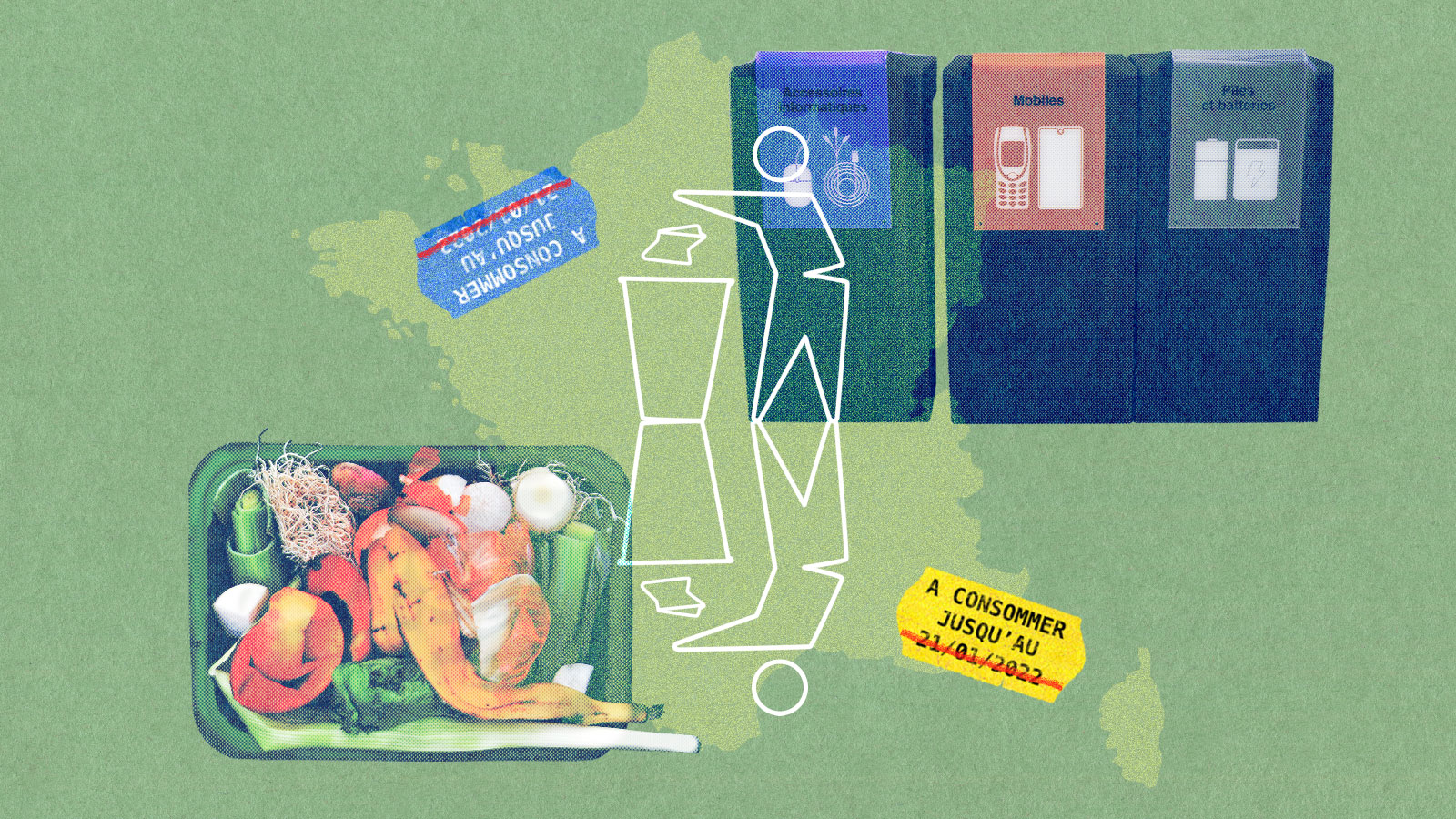
Allie “Nokko” Johnson is a member of the Coushatta Tribe of Louisiana, and they love teaching young tribal members about recycling. Johnson helps them make Christmas ornaments out of things that were going to be thrown away, or melts down small crayons to make bigger ones.
“In its own way, recycling is a form of decolonization for tribal members,” Johnson said. “We have to decolonize our present to make a better future for tomorrow.“
The Coushatta Reservation, in southern Louisiana, is small, made up of about 300 tribal members, and rural — the nearest Walmart is 40 minutes away. Recycling hasn’t been popular in the area, but as the risks from climate change have grown, so has the tribe’s interest. In 2014, the tribe took action and started gathering materials from tribal offices and departments, created recycling competitions for the community, and started teaching kids about recycling.
Recently, federal grant money has been made available to tribes to help start and grow recycling programs. Last fall, the Coushatta received $565,000 from the Environmental Protection Agency for its small operation. The funds helped repair a storage shed, build a facility for the community to use, and continue educational outreach. But it’s not enough to serve the area’s 3,000 residents of Native and non-Native recyclers for the long haul.
Typically, small tribes don’t have the resources to run recycling programs because the operations have to be financially successful. Federal funding can offset heavy equipment costs and some labor, but educating people on how to recycle, coupled with long distances from processing facilities, make operation difficult.
But those figures don’t truly illuminate the scale of the world’s recycling product. Around 8.3 billion metric tons of plastic have been manufactured since the 1950’s and researchers estimate that 91 percent of it isn’t recycled. In the United States, the Department of Energy finds that only 5 percent is recycled, while aluminum, used in packaging has a recycling rate of about 35 percent. The recycling rate for paper products, including books, mail, containers, and packaging, is about 68 percent.
There are no nationwide recycling laws in the U.S., leaving the task up to states, and only a handful of states take it seriously: Ten have “bottle bills,” which allow individuals to redeem empty containers for cash, while Maine, California, Colorado, and Oregon have passed laws that hold corporations and manufacturers accountable for wasteful packaging by requiring them to help pay for recycling efforts. In the 1960s, the U.S. recycling rate across all materials — including plastic, paper, and glass — was only 7 percent. Now, it’s 32 percent. The EPA aims to increase that number to 50 percent nationwide by 2030, but other than one law targeted at rural recycling moving through Congress, there are no overarching national recycling requirements to help make that happen.
In 2021, Louisiana had a recycling rate of 2.9 percent, save for cities like New Orleans, where containers are available for free for residents to use to recycle everything from glass bottles to electronics to Mardi Gras beads. In rural areas, access to recycling facilities is scarce if it exists at all, leaving it up to local communities or tribal governments to provide it. There is little reliable data on how many tribes operate recycling programs.
“Tribal members see the state of the world presently, and they want to make a change,” said Skylar Bourque, who works on the tribe’s recycling program. “Ultimately, as a tribe, it’s up to us to give them the tools to do that.”
But the number one issue facing small programs is still funding. Cody Marshall, chief system optimization officer for The Recycling Partnership, a nonprofit, said that many rural communities and tribal nations across the country would be happy to recycle more if they had the funds to do so, but running a recycling program is more expensive than using the landfill that might be next door.
“Many landfills are in rural areas and many of the processing sites that manage recyclables are in urban areas, and the driving costs alone can sometimes be what makes a recycling program unfeasible,” he said.
The Recycling Partnership also provides grants for tribes and other communities to help with the cost of recycling. The EPA received 91 applications and selected 59 tribal recycling programs at various stages of development for this year, including one run by the Muscogee (Creek) Nation in Oklahoma, which began its recycling program in 2010. Today, it collects nearly 50 metric tons of material a year — material that would have otherwise ended up in a landfill.
“Once you start small, you can get people on board with you,” said James Williams, director of the Muscogee (Creek) Nation’s Environmental Services. He is optimistic about the future of recycling in tribal communities. “Now I see blue bins all through the nation,” he said, referring to the recycling containers used by tribal citizens.
Williams’ department has cleaned up a dozen open dumps in the last two years, as well as two lagoons — an issue on tribal lands in Oklahoma and beyond. Illegal dumping can be a symptom of lack of resources due to waste management being historically underfunded. Those dumping on tribal land have also faced inadequate consequences.
“We still have the issue of illegal dumping on rural roads,” he said, adding that his goal is to clean up as many as possible. “If you dump something, it’s going to hit a waterway.”
According to Williams, tribes in Oklahoma with recycling programs work together to address problems like long-distance transportation of materials and how to serve tribal communities in rural areas, as well as funding issues specific to tribes, like putting together grant applications and getting tribal governments to make recycling a priority. The Choctaw Nation in Oklahoma also partners with Durant, a nearby town. Durant couldn’t afford a recycling program of their own, so they directed recycling needs to the tribe.
This year’s EPA grant to the Muscogee program purchases a $225,000 semitruck, an $80,000 truck for cardboard boxes, and a $200,000 truck that shreds documents. Muscogee was also able to purchase a $70,000 horizontal compactor, which helps with squishing down materials to help store them, and two $5,000 trailers for hauling. Williams’ recycling program operates in conjunction with the Muscogee solid waste program, so they share some of their resources.
Returns on recycled material aren’t high. In California, for instance, one ton of plastic can fetch $167, while aluminum can go for $1,230. Corrugated cardboard can also vary wildly from $20 to $210 a ton. Prices for all recycled materials fluctuate regularly, and unless you’re dealing in huge amounts, the business can be hard. Those who can’t sell their material might have to sit on it until they can find a buyer, or throw it away.
Last year, Muscogee Creek made about $100,000 reselling the materials it collected, but the program cost $250,000 to run. The difference is made up by profits from the Muscogee Creek Nation’s casino, which helps keep the recycling program free for the 101,252 tribal members who live on the reservation. The profits also help non-Natives who want to recycle.
The Coushatta Tribe serves 3,000 people, Native and non-Native, and they have been rejected by 12 different recycling brokers – individuals that act as intermediaries between operations and buyers – due to the distance materials would have to travel.
Allie Johnson said she couldn’t find a broker that was close enough, or that was willing to travel to the Coushatta Tribe to pick up their recycling. “We either bite the cost,” she said, “or commute and have to pay extra in gas. It’s exhausting.”
Currently, the only place near them that’s buying recyclables is St. Landry Parish Recycling Center, which only pays $0.01 per pound of cardboard. A truck bed full of aluminum cans only yields $20 from the nearest center, 90 minutes away. That’s how much the tribe expects to make for now.
Still, the Coushatta Tribe of Louisiana is not giving up.
With this new injection of federal money, they will eventually be able to store more materials, and hopefully, make money back on their communities’ recyclables. Much like the Muscogee Creek Nation, they see the recycling program as an amenity, but they still have hopes to turn it into a thriving business.
In the meantime, the Coushatta keep up their educational programming, teaching children the value of taking care of the Earth, even when it’s hard.
For a decade, wind farm companies had been eyeing Molok Luyuk — a mountain ridge of religious importance to tribes in northern California, whose people have worked for years to protect it. It’s also widely biodiverse with elk, mountain lions, and black bears, as well as 40 rare plants such as the pink adobe lily.
Mia Durham is the secretary for the Yocha Dehe Wintun Nation, a tribe that has been in a relationship with Molok Luyuk for thousands of years. In response to petitions filed by wind energy companies that wanted to develop the area, the tribe and its allies asked President Biden to protect it in 2019.
“That’s what heightened it for us and put us on track of moving forward as quickly as possible,” Durham said. “We wanted to protect sacred sites that are there. They were going to be severely impacted.”
One way to protect landscapes and waterways such as Molok Luyuk is to have them declared national monuments, a term used to designate that a section of land is federally protected from development and harm. While Congress designates national parks, only a president can designate a national monument.
That’s what happened earlier this month when the Biden administration expanded a national monument to include Molok Luyuk, joining the mountain ridge to the nearby Berryessa Snow Mountain National Monument, nearly 350,000 acres of coastal range in northern California. Tribes are now working on a co-stewardship agreement for the Molok Luyuk area, but not for the whole national monument.
But the tribes that have a relationship with Molok Luyuk aren’t done with their advocacy. They’ve protected the area from energy development, but they still have little say in how the land is managed. While the federal government has pushed co-stewardship agreements over the years, national monuments are still considered property of the federal government.
Now that Berryessa includes Molok Luyuk, the U.S. Forest Service and the Bureau of Land Management are in talks to enter into a co-stewardship agreement with the Yocha Dehe Wintun Nation, Kletsel DeHe Wintun Nation, and the Cachil DeHe Band of Wintun Indians of the Colusa Rancheria. The details are still being hashed out, but the Yocha Dehe Wintun Nation is excited to bring traditional knowledge to the management of Molok Luyuk.
Melissa Hovey is the manager at Berryessa Snow Mountain National Monument, and she said that co-management happens between the Bureau of Land Management and the U.S. Forest Service. These federal agencies can enter into co-stewardship agreements with tribes, but they can’t delegate management without congressional approval.
“Co-management means decision-making authority,” she said. “Co-stewardship means one entity still has the decision-making authority.”
You would think that “co-stewardship” and “co-management” would be simple terms to define, but there are numerous federal documents that have used the two terms interchangeably over the years. Co-stewardship is a broad term that describes agreements made between federal agencies and tribal nations to hash out shared interests in the management of federal lands. Co-management refers to a stronger tribal presence and decision-making power.
The Biden administration has been pushing co-stewardship as a model for how federal agencies can build relationships with Indigenous nations. Tribes were forcibly removed from much of their ancestral homeland in the U.S., and so many are dispossessed from medicines, food, and ceremonial places that are now under federal management.
In 2015, the Berryessa Snow Mountain National Monument was created under President Obama using the Antiquities Act — a 1906 law that allows the president to protect places of historic and scientific interest on federal land and make them national monuments. Berryessa was protected because of the area’s biodiversity: 80 different species of butterflies, black bears, California newts, and predatory birds. Molok Luyuk translates from Patwin to English as “Condor Ridge,” in reference to the endangered California condor that used to fly along the ridge.
Congressional action is not the only way to gain co-management powers. The Bears Ears Inter-Tribal Coalition in Utah has one of the most successful stories of tribes gaining co-management status — they were given “true co-management” by an Intergovernmental Cooperative Agreement. In 2022, the federal government agreed to co-manage Bears Ears National Monument with the Hopi Tribe, Navajo Nation, Ute Mountain Ute Tribe, Ute Indian Tribe of the Uintah and Ouray Reservation, and the Pueblo of Zuni. For the first time ever, tribal nations worked with federal agencies to draft a resource-management plan that would dictate how a national monument should be run.
Bears Ears National Monument in Utah is co-managed by the U.S. federal government and an intertribal coalition that includes six Indigenous nations. George Frey / Getty Images
Patrick Gonzales-Rogers is a professor at the Yale School of Environment where he specializes in tribal sovereignty and natural resources. He is also the former director of the Bears Ears Inter-Tribal Coalition.
Co-managment allows tribes to exercise sovereignty, according to Gonzales-Rogers. “It allows them to be more assertive,” he added. And when that happens, tribes can bring in religious and spiritual practices to utilize traditional knowledge, wisdom that had been minimized by federal agencies in the past.
Gonzales-Rogers is hopeful that, exponentially, these choices will compound, “and may even have a nexus to say something like landback” a reference to a movement that is not only rooted in a mass return of land to Indigenous nations and peoples, but also tribes having sovereignty to steward the land that was taken from them.
Gonzales-Rogers thinks the two terms have not been very well-defined over the years, but said co-stewardship agreements might be a good way to start building to co-management.
Conservation efforts are more effective when Indigenous peoples and local communities are given more autonomy and involvement over their lands. That’s according to a new study published this month in the sustainability journal One Earth.
Researchers analyzed 648 studies of conservation areas between 1991 and 2020, about half of which had data on either the ecological or social outcomes of specific environmental protection efforts. Authors then categorized each conservation case based on the degree to which Indigenous peoples and local communities were involved, ranging from complete exclusion from the process to having full autonomy and decision-making power recognized by authorities. Researchers then conducted statistical analyses comparing the social and ecological outcomes of each case to determine trends across categories.
They discovered that even though including Indigenous peoples and local communities is often talked about as a moral or ethical imperative, it’s actually better for the environment. The researchers noted their findings have significant implications for ongoing global efforts to ramp up conservation and tackle climate change.
“The findings reveal that more equitable governance, based on equal partnership or primary control for [Indigenous peoples and local communities], are associated with significantly more positive ecological outcomes,” the authors concluded.
The study found that in the hundreds of conservation cases they reviewed, Indigenous peoples and local communities were most often treated as stakeholders or consultees, with little to no power over the conservation project. It was rare for their rights and full autonomy to be respected.
But in such cases where the latter did occur, the study authors found conservation efforts were far more likely to be successful. Their analysis found that positive ecological outcomes were associated with 85 percent of cases where Indigenous peoples’ and local communities’ autonomy was respected, compared with just 18 percent of the cases where Indigenous peoples or local communities were simply treated as stakeholders.
The researchers pointed to the Los Lagos Indigenous Marine Areas established by Chile in 2012 as an example of an effective conservation effort.
“Indigenous groups fought for control, access to marine resources, and the ability to restore them through their own values and institutions, eventually winning against the tide of rapid coastal economic development and weak environmental regulations,” the authors wrote. “The shift to inclusive Indigenous institutions and collective custodianship produced transformational positive social and ecological outcomes relative to intensive commercial agriculture.”
In contrast, the authors found when China established the eco-province of Hainan in 1994, authorities excluded the Li peoples from involvement.
“The new governance regime was weakly enforced, poorly resourced, and lacked accountability, which reduced effectiveness by providing conditions that were exploited for corrupt logging, relative to when communities themselves helped regulate extraction,” the study said.
In addition to better environmental outcomes, the researchers found positive social outcomes, such as higher incomes and better social relations, also associated with projects that had the greatest respect for Indigenous rights. More than half of the conservation efforts that recognized Indigenous peoples’ and local communities’ primary control, or full autonomous control, reported positive social outcomes. When Indigenous peoples or local communities were merely consulted, beneficial social effects were negligible.
The study emphasizes that allowing Indigenous peoples to steward their own lands is better for the environment than ignoring their rights.
“This carries important implications, including for actions toward the Global Biodiversity Framework targets, suggesting a need to elevate the role of [Indigenous peoples and local communities] to conservation leaders while respecting their rights and customary institutions,” the authors concluded.
A new federal report found that federal agencies frequently fail to collect the same amount of data about U.S. territories that they collect, and maintain, for states, which advocates say has wide implications for climate adaptation and mitigation.
The report, authored by the U.S. Government Accountability Office, or GAO, examined federal data collection in five island territories: Puerto Rico, the U.S. Virgin Islands, the Commonwealth of the Northern Mariana Islands, Guam, and American Samoa. The latter three are home to relatively large communities of Indigenous Pacific Islanders. Guam, American Samoa, and the Virgin Islands are currently on the United Nations’ list of non-self-governing territories, a list of modern colonies whose peoples have not yet achieved self-government. All U.S. territories are experiencing the impacts of warming oceans, more frequent and violent storms, and bleaching coral reefs.
“As the saying goes, if you don’t count, then you don’t count,” said Neil Weare, co-director of Right to Democracy, an advocacy group for residents in U.S. territories. “If folks are serious about environmental justice, they need to be serious about addressing equity issues in U.S territories, particularly when it comes to issues of data collection.”
The GAO report doesn’t specifically mention climate change, but much of the missing data is closely related: demographics, economics, and agriculture. For instance, of all the National Agricultural Statistics Services’ statistical products, only one includes data from the territories. In American Samoa, where subsistence agriculture is becoming increasingly important to address gaps in food security and is also highly susceptible to the impacts of climate change, local officials say the census may undercount farms by relying too heavily on the presence of electric meters.
Some of the barriers to data collection are statutory: Federal legislation often leaves out U.S. territories. But other barriers include limited sample sizes due to relatively small populations; the high cost of collecting data, especially when agencies lack local staff; and technical challenges including a lack of residential postal addresses or postal delivery services on many islands that the Census Bureau normally relies on to mail surveys. The Bureau of Labor Statistics includes Puerto Rico in just four of its 21 statistical products, and it doesn’t include American Samoa or the Commonwealth of the Northern Mariana Islands in any of them. The agency says it excludes Guam, American Samoa, and the Northern Mariana Islands from many of its labor statistics in part because they don’t have local unemployment insurance programs.
On Guam, local officials said they’re often excluded from the federal Social Vulnerability Index, which estimates communities’ susceptibility to natural disasters, and worry that the lack of inclusion leads to underestimates of their need for resources. Guam and the Northern Mariana Islands, which make up the same western Pacific archipelago, are frequently hit with typhoons and are still recovering from Typhoon Mawar and Yutu, the latter of which was the strongest storm in nearly a century to hit the U.S.
The report said that the Biden administration should ensure that the chief statistician at the Office of Management and Budget develop a plan for how to address the data gaps in consultation with the territories. This is encouraging to Neil Weare, who says it puts the onus on the Biden administration to act quickly.
“One of the key takeaways from that report is that the Biden administration can take action on many, if not almost all, of these items without further congressional approval,” Weare said. “So this really does set the stage for the Biden administration to act on these issues.”
As the planet grapples with the ever-starker consequences of climate change, a debut book by Lumbee citizen and Duke University scientist Ryan Emanuel makes a convincing argument that climate change isn’t the problem — it’s a symptom. The problem, Emanuel explains in On the Swamp: Fighting for Indigenous Environmental Justice, is settler colonialism and its extractive mindset, which for centuries have threatened and reshaped landscapes including Emanuel’s ancestral homeland in what today is eastern North Carolina. Real environmental solutions, Emanuel writes, require consulting with the Indigenous peoples who have both millennia of experience caring for specific places, and the foresight to avoid long-term disasters that can result from short-term material gain.
Born in Charlotte, North Carolina, in 1977, Emanuel was one of a handful of Native students at school. He spent summers visiting family in Robeson County, North Carolina, the cultural center of the Lumbee Tribe, or People of the Dark Water, where he played outside with other children, occasionally exploring a nearby swamp, one of the many lush waterways that slowly wind through the region, with a cousin. Today, Emanuel visits those swamps to conduct research. He describes them with an abiding, sometimes poetic affection, such as one spring day when he stands calf-deep in swamp water, admiring white dogwood flowers floating on the dark surface as tadpoles dart underneath.
But that affection lives with tension. Emanuel describes trying to collect “reeking” floodwater samples from a ditch after 2018’s Hurricane Florence. In Emanuel’s retelling, a nearby landowner — a white farmer who uses poultry waste as fertilizer — threatens to shoot Emanuel. The sampling, the man believes, would threaten his livelihood, which is wrapped up in North Carolina’s extractive animal farming industry — a system of giant, polluting “concentrated animal feed operations” overwhelmingly owned and operated by white people, and exposing mainly racial minorities to dirty air and water. They are a sharp contrast to the small backyard farms and truck crops grown by Emanuel’s aunties and uncles back in Robeson County a generation ago. As the man holds his gun and lectures about environmental monitoring, Emanuel reflects silently that they are standing on his ancestors’ land. Ever the researcher, he later finds deed books from around the Revolutionary War showing Emanuels once owned more than a hundred acres of land in the vicinity. Still, he holds a wry sympathy for the man, who, he notes, is worried that environmental data will jeopardize his way of life in a place his family has lived for generations.
Eastern North Carolina is a landscape of sandy fields interwoven with lush riverways and swamplands, shaded by knobby-kneed bald cypress trees and soaked with gently-moving waterways the deep brown of “richly steeped tea,” Emanuel writes. In addition to water, the region oozes history: It includes Warren County, known as the birthplace of the environmental justice movement, where local and national civil rights leaders, protesting North Carolina’s decision to dump toxic, PCB-laden soil in a new landfill in a predominantly-Black community, coined the term “environmental racism.” It’s also the mythological birthplace of English colonialism, Roanoke Island. On the Swamp draws a through line from early colonization of the continent to ongoing fights against environmental racism and for climate justice, with detailed stops along the way: Emanuel’s meticulous research illustrates how the white supremacism that settlers used to justify colonialism still harms marginalized communities — both directly, through polluting industries, and indirectly, through climate change — today.
With convoluted waterways accessible only by small boats, and hidden hillocks of high ground where people could camp and grow crops, the swamplands of eastern North Carolina protected Emanuel’s ancestors, along with many other Indigenous peoples, from genocide and enslavement by settlers. Today, with climate change alternately drying out swamplands or flooding them with polluted water from swine and poultry operations, it’s the swamps that need protection, both as a geographic place, and an idea of home. The Lumbee nation is the largest Indigenous nation in the eastern United States, but because the Lumbee Tribe gained only limited federal recognition during the 1950s Termination Era, its sovereignty is still challenged by the federal government and other Indigenous nations. Today, federal and state governments have no legal obligation to consult with the Lumbee Tribe when permitting industry or development, although the federal government does with Indigenous nations that have full federal recognition, and many industrial projects get built in Robeson County.
In writing that’s both affectionate and candid, On the Swamp is a warning about, and a celebration of, eastern North Carolina. Though the region seems besieged by environmental threats, Indigenous nations including the Lumbee are fighting for anticolonial climate justice.
Grist recently spoke with Emanuel about On the Swamp.
This interview has been edited for clarity and length.
Q. What motivated you to write this book?
A. Many years ago, I thought that I wanted to write a feel-good book about celebrating the Lumbee River and the Lumbee Tribe’s connection with it, and talking about all the reasons why it’s beautiful, and amazing, and important to us. So I thought that I would write this essentially nature story, right? But as my work evolved, and as I started thinking more critically about what I actually should be writing, I realized that I couldn’t tell that love story about the river without talking about difficult issues around pollution, climate change, and sustainability, and broader themes of environmental justice and Indigenous rights.
Q. Could you tell me about your connection to place?
A. I have a relationship to Robeson County that’s complicated by the fact that my family lived in Charlotte, and I went to school in Charlotte, and we went to church in Charlotte. But two weekends every month, and every major holiday, we were in Robeson County. And so I’m an insider, but I’m also not an insider. I’ve got a different lens through which I look at Robeson County because of my urban upbringing, but it doesn’t diminish the love that I have for that place, and it doesn’t keep me from calling it my home. I’ve always called it home. Charlotte was the place where we stayed. And Robeson County was home.
I can’t see the Lumbee River without thinking about the fact that it is physically integrating all of these different landscapes that I care about, [and] a truly beautiful place.
Q. In 2020, after years of protests and legal battles, Dominion Energy and Duke Energy canceled the Atlantic Coast pipeline, which would have carried natural gas 600 miles from West Virginia to Robeson County. In On the Swamp, you note that a quarter of Native Americans in North Carolina lived along the proposed route of the Atlantic Coast Pipeline. What was the meaning of the Atlantic Coast pipeline project for Lumbee people?
A. That was an issue very few Lumbee people paid attention to, until they saw the broader context to the project and realized that such an outsized portion of the people who would be affected by the construction and operation of that pipeline were not only Native American, but were specifically Lumbee. I think that’s what generated a lot of outrage, because for better or for worse, we’re used to being treated like a sacrifice zone.
The Atlantic Coast pipeline gave us an easy way to zoom out and ask questions like, “OK, who is going to be affected by this project? Who’s making money off of this project?”
It was also a way to engage with larger questions about things like energy policy in the face of climate change and greenhouse gas emissions. [It] brought up philosophical questions of how we feel about the continued use of fossil fuels and the investment in brand new fossil fuel infrastructure that’s going to last 30, 40, or 50 years, at a time when everybody knows we shouldn’t be doing that.
Q. At the end of the day, the Atlantic Coast pipeline didn’t happen. What do you think is the main reason?
A. The collective resistance of all of these organizations — tribal nations, committed individuals, grassroots organizations — was enough to stall this project, until the developers realized that they had fallen into the Concorde fallacy. Basically, they got to the point where they realized that spending more money was not going to get them out of the hole they had dug in terms of opposition to this project.
But as long as [developers] hold on to those [property] easements, there’s certainly a threat of future development.
Q. You write that people can physically stay on their ancestral land and still have the place taken away by climate change, or by development projects. Can you talk a little bit about still having the land but somehow losing the place?
A. The place is not a set of geographic coordinates. It’s an integration of all the natural and built aspects of the environment. And so climate change, deforestation, these other types of industrialized activities, they have the potential to sweep that place out from under you, like having the rug pulled out. All of the things that make a set of geographic coordinates a beloved place can become unraveled, by these unsustainable processes of climate change and unsustainable development. I think that the case studies in [On the Swamp] show some of the specific ways that that can happen.
Q. Could you talk about your experiences as a researcher going out in the field, navigating modern land ownership systems, and how that connects to climate change?
A. I don’t know if it’s fair to say that I have to bite my tongue a lot, but I kind of feel that way. When I hear people talk about their ownership of our ancestral lands — I’m a mix of an optimist and a realist, and I understand that we’re not going to turn back the clock. And frankly, I’m not sure I want to, because Lumbee people are ourselves a product of colonial conflict, and we wouldn’t exist as the distinct nation that we are today, if it were not for the colonial violence that we survived. We might exist as our ancestral nations and communities, but we definitely wouldn’t be Lumbee people. So this is a complicated issue for me.
When we think about the front lines of climate change, we don’t often think about Robeson County, North Carolina. But because our community is so attuned to that specific place, we’re not going to pick up and move if the summers get too hot, or if the droughts are too severe. That’s not an option for us. So I think that some of the urgency that I feel is not too different from the urgency that you hear from other [Indigenous] people who are similarly situated on the front lines of climate change.
Q. Something else that you make a really strong point about in this book is that something can be a “solution” to climate change, but not sustainable, such as energy companies trying to capture methane at giant hog farms in Robeson County. How should people think about climate solutions, in order to also take into account their negatives?
A. The reason why people latch onto this swine biogas capture scheme is if you simply run the numbers, based on the methane and the carbon dioxide budgets, it looks pretty good.
But a swine facility is a lot more than just a source of methane to the atmosphere, right? It’s all these other things in terms of water pollution, and aerosols, and even things like labor issues and animal rights. There are all these other things that are attached to that kind of facility. If you make a decision that means that facility will persist for decades into the future operating basically as-is, that has serious implications for specific people who live nearby, and for society more broadly. We don’t tend to think through all those contingencies when we make decisions about greenhouse gas budgets.
Q. What are some ways that the Lumbee tribe is proactively trying to adapt to climate change?
A. Climate change is not an explicit motivation [for the Lumbee Tribe]. If you go and read on the Lumbee Tribe’s housing programs website, I don’t think you’re going to find any rationale that says, “We’re [building housing] to address climate change.” But they are.
Getting people into higher-quality, well-insulated and energy-efficient houses is a big deal when it comes to addressing climate change, because we have a lot of people who live in mobile homes, and those are some of the most poorly insulated and least efficient places that you could be. And maybe 40 years ago, when our extreme summer heat wasn’t so bad, that wasn’t such a huge deal. But it’s a huge deal now.
Q. What is the connection between colonialism and climate change for eastern North Carolina, and why is drawing that line necessary?
A. The one sentence answer is, “You reap what you sow.”
The longer answer is, the beginning of making things right is telling the truth about how things became wrong in the first place. And so I really want this book to start conversations on solving these issues. We really can’t solve them in meaningful ways unless we not only acknowledge, but also fully understand, how we got to this point.
The Colorado River Indian Tribes now have the ability to lease their water rights off-reservation, a move that could ease pressures on communities facing the effects of climate change through drought. The option may prove to be financially beneficial for the Colorado River Indian Tribes, also known as CRIT, but experts say the ability of the tribe to enter the water market is an outlier: For Indigenous Nations in the Southwest with a desire to sell their water, the process is so convoluted, it may take years before tribes, or non-tribal communities to see any financial benefit or much needed water.
This month, CRIT leadership, Interior Secretary Deb Haaland, and Arizona Governor Katie Hobbs signed a historic agreement on the banks of the Colorado River, allowing their water to be leased to off-reservation parties like government entities and corporations. “This is a significant event in the history of CRIT. These agreements clear the path for CRIT to be finally recognized as a central party in all future decisions regarding the Colorado River,” Chairwoman Amelia Flores wrote in a press release.
But it wasn’t easy to get here.
CRIT comprises four tribes: the Mohave, Chemehuevi, Hopi, and Navajo, who, in 1964, secured their water rights along the river — 719,248 acre feet of water annually, making CRIT the largest water rights holders in the basin. Today, CRIT maintains a number of agricultural projects on about 80,000 acres of land, growing alfalfa, cotton, potatoes, and wheat. But much of the water infrastructure used to support those operations was built in the late 1800s and suffers from problems like unlined canals and deteriorating irrigation gates.
Around 2018, CRIT became interested in leasing water to nearby communities as a way to make money and potentially conserve water, and in 2022, Congress passed the Colorado River Indian Tribes Water Resiliency Act, legislation that would allow CRIT to enter into water sharing agreements with the federal government and the state of Arizona. But this need for legislation is the central issue: Indigenous Nations are not allowed to lease or sell their lands or water without congressional approval due to the Indian Non-Intercourse Act passed in 1834. According to Daniel Cordalis, an attorney with the Native American Rights Fund, it’s a law that has long outlasted its usefulness.
“Tribes should be able to manage and derive benefit from all their water rights and be an active part of solving the Colorado River’s water use puzzle,” said Cordalis. “As it stands now, only a few tribes can participate in a truly meaningful way.”
Another tribal community, the Gila River Indian Community, a few hours southwest of CRIT, has been able to lease water for decades. After securing their water rights in 2004, Gila River negotiated a settlement in exchange for federal funding for water infrastructure and access to water delivery systems to the tune of $850,000. Originally they asked for 2.1 million acre feet of water, but they received 653,500 acre feet. The state and Interior still have a say in what they are allowed to do with their water.
But again, these two tribes are the outliers — most tribes still can’t lease their water. In order to get on the water market, tribes have to figure out how much water is theirs, have their right to that water recognized by the federal government, petition Congress for permission to lease some of that water, then get state and federal officials to sit down and sign an agreement that allows that tribe to enter into additional agreements that must then be approved by those same state and federal officials.
Liliana Soto, the press secretary for Arizona Governor Katie Hobbs, she said that water agreements with tribes could lead to water conservation, shortage mitigation, and alternatives to groundwater use.
“The state’s collaboration with CRIT has been key to making this leasing possibility a reality, and Governor Hobbs sees this as one of the many ways we are strengthening partnerships with tribal nations,” she said.
Another solution to this long water leasing process is to create a uniform system for tribes to enter into off-reservation leasing. Samuel Joyce is an attorney with a focus on tribal law, who this year published in the Stanford Law Review about the issue with CRIT’s situation and the larger implications. As the Colorado River Indian Tribes Water Resiliency Act only applies to one tribe, Joyce argued that Congress could pass legislation that would make it easier for tribes to enter the water market.
Joyce also recognizes that legislation should be coupled with a streamlined process to settle water rights for nearly a dozen tribes that are currently awaiting court decisions.
“Reforms to make it easier for tribes to quantify their water rights should accompany leasing authorization,” Joyce wrote. “Even though tribes have senior water rights, political opposition will only grow as non-Indian users expand and climate change further reduces available water in the Colorado basin, putting priority on quantifying tribal water rights now.”
In another paper released last year, written by Bryan Leonard, a professor of environment and natural resources at the University of Wyoming, tribes were estimated to earn between $938 million and $1.8 billion in revenue a year if they were able to use all of their water allocations. Currently, tribes use only about 8 percent of their allocated water, and the rest flows downstream to users who essentially get it for free.
“Markets are only as good as the underlying property rights and institutions,” Leonard said. “The unfortunate thing for reservations is that they’re saddled with colonial-era institutions to manage their resources.”
Per the Colorado River Indian Tribes Water Resiliency Act, the tribe can only lease water in the Lower Basin, which is most of the state of Arizona. With a population boom in Phoenix, only a few hours away from CRIT, the tribe’s water could help the next influx of those flocking to the West.
This story was originally published by ICT and is reproduced here as part of the Global Indigenous Affairs Desk, an Indigenous-led collaboration between Grist, High Country News, ICT, Mongabay, Native News Online, and APTN.
A little more than a century ago the village of Taholah was built where the ocean meets the Quinault River. Today when there’s too much rain, or a storm surge, water will rush past Quinault Street, down 2nd, 3rd all the way across town, filling yards and homes with salt water.
Ryan Hendricks points to the sea wall and remembers one such flood. “It’s almost like a geyser shooting through the rocks,” said Hendricks, a member of the Quinault Indian Nation’s Tribal Council. “The water was coming in from the river and just coming directly into the village. And then over here … the water wasn’t coming really over the wall. It was just coming through the rocks like a geyser. So it was just pushing almost with the speed of like a natural river current.”
The Quinault Nation faces dangerous long-term currents. Taholah is barely inches above the ocean and the sea level is rising. On top of that there are a growing number of storm surges, where flood waters are propelled by high winds.
What makes the Quinault story so powerful is that it’s a window into our future: It’s the idea that a changing climate will determine where and how we will live, what we will eat, and how much it’s going to cost.
The Quinault Nation has been deliberate in its response, debating for the past couple of decades about how to protect its lands, its fish, people, and property. After many community meetings the conclusion was reached in a 2017 tribal master plan, a move to higher ground.
That plan included a new village, about a half-mile uphill, that will protect residents from storm surges or even a potential catastrophic tsunami. Relocation will “incorporate smart growth techniques including low-impact development and green infrastructure to better prepare the community for the future climate.”
Ryan Hendricks, a member of the Quinault Indian Nation’s Tribal Council, points to the village’s sea wall.
Stewart Huntington/ICT
The easy part of relocation is already done. The nation has constructed what’s needed for a new community. The streets are paved. The sewers are in. And only a couple of things are missing: houses and residents.
The new village “must be designed to be as resilient as possible,” the master plan said. “Even small events, such as windstorms, close roads and down power lines, isolating the village. Thus, planning for safe havens in case of disaster and alternative energy sources is a must when determining facility siting, sizing, orientation, and programming.”
In a reflection of Indigenous values, the first building opened by the nation was the Generations House, a 30,000-square-foot building serving elders, Head Start, day care, and adult education.
“This was our most modern effort to relocate our most vital citizens with all of our next generations,” Hendricks says. “This is a shared building with all of our most valuable resources, our children. And then, all of our most valuable information holders are our elders on the other side [of the building].”
The Generations House is also the gathering point should there be an emergency.
There are a lot of questions that still must be answered before any houses are built.
“We have penciled out what a house would cost. And right now we are sitting at somewhere between $350 and $400,000 per house,” Hendricks says. That is a number unaffordable for most tribal members.
And what about the people now living in Taholah who have paid off their mortgages — especially elders?
“Why would they come up with a new mortgage? Well, they already have a house for themselves. And then there’s someone who said, ‘Well, we don’t have the means to pay for a new home. Is the tribe going to buy my home?’” asks Hendricks.
That means the nation still must work through these scenarios and come up with individual solutions.
And that starts with a community-based plan.
“I had the chance to visit Quinault a year ago, and they are doing just amazing work on climate relocation and climate resilience,” said Bryan Newland, the Interior Department’s assistant secretary for Indian affairs. “It’s one of three communities that are going to serve as kind of pilot projects, if you will, on community driven relocation. And they’re just doing amazing work. I was really impressed by their foresight in their planning and how they are really thinking through a lot of issues that aren’t intuitive and working to address them. And so I’ve been really impressed. And, you know, we shouldn’t be surprised that when tribes have resources, they’re able to do very impressive things. And so I look forward to seeing where they’re going to take that.”
For now the bottom line is that the Quinault Nation is not sure where more than $450 million will come from to pay for this relocation.
But here’s the thing. The Quinault Nation is further along in this sort of planning than nearly every community on the planet. When we drove up the coast to get here, we passed through low-elevation towns and even cities that reflect the scale of the problem. And it’s clear that neither the region nor the country are penciling out what has to be done and what it will cost.
Earlier this year, Arizona lawmakers sued the Biden administration over the newly created Baaj Nwaavjo I’tah Kukveni — Ancestral Footprints of the Grand Canyon National Monument — arguing that the establishment of national monuments should be state matters and calling the move a “land grab.” Now, the Hopi, Havasupai, and Navajo Nation, whose ancestral lands overlap with the national monument, have intervened in the case and joined with the federal government to protect the area.
“Even if the Tribal Nations and federal government share similar goals and legal positions in this litigation, the United States cannot adequately represent the Tribal Nations’ sovereign interest,” the tribes’ intervention stated.
The nearly one-million acre national monument protects areas tribes called home before being forcibly removed by the federal government, as well as places where tribal citizens hunt, pray, and gather foods and medicines. The area is also important for wildlife migration routes and potential burial sites.
If successful, Arizona’s lawsuit would open Baaj Nwaavjo I’tah Kukveni to more economic development, and specifically, livestock grazing and uranium mining. Currently, there is only one uranium mine in operation within the boundaries of the national monument. The lawsuit argues that limiting mining of uranium around the Grand Canyon will make the U.S. more dependent on acquiring it from foreign countries for energy purposes.
Arizona’s lawsuit is focused specifically on the Antiquities Act. Passed in 1906 to protect areas of scientific and historical significance, President Biden used the act to create Baaj Nwaavjo I’tah Kukveni after decades of Indigenous advocacy focused on protecting the Grand Canyon from uranium mining. According to Arizona, the national monument ties up too much land, impacting revenue generation that could affect funding for schools as well as the economies of small towns in the area who have also joined in the suit against the federal government.
“Under the constitution, Congress is the policy making branch of government that decides how federal land is used,” Kim Quintero, a spokesperson for the Arizona Legislature. “Not presidential edicts.”
“When you think about Baaj Nwaanjo I’tah Kukveni and the creation of this monument, it’s an immensely important place for the tribal nations,” said Mathew Cambell, a member of the Native Village of Gambell in Alaska, and legal counsel for the Havasupai Tribe and the Hopi Tribe. “The tribes fought very hard for the establishment of the monument and are here to defend it.”
Last year, a federal judge in Utah dismissed a similar lawsuit filed by states challenging the Bears Ears and Grand Staircase Escalante—two national monuments recently-created through the Antiquities Act with strong tribal ties. In that case, District Judge David Nuffer held that the Antiquities Act gives the president authority to create monuments and that the courts have no power to dispute it. That case is now in appeal.
But Kim Quintero of the Arizona Legislature says their case is different. She cites a 2021 lawsuit where a group of commercial fishermen challenged President Obama’s use of the Antiquities Act that protected around five-thousand miles of ocean floor off the coast of New England, and put a ban on fishing.
While the Supreme Court declined to review the case, Chief Justice John Roberts indicated interest in looking at the size of monuments writing that “the scope of the objects that can be designed under the Act, and how it measures the area necessary for their proper care and management, may warrant consideration– especially given the myriad restrictions on public use this purely discretionary designation can serve to justify.”
Quintero says the Arizona Legislature is banking on the Supreme Court taking the case. If successful, she said there will be other avenues for tribes to utilize in protecting the area.
“Tribal members, like other members of the public, can petition Congress to pass laws to protect areas of federal land they believe should be protected,” said Quintero.
Nine conservation organizations including the Grand Canyon Trust, Center for Biological Diversity, and Sierra Club have signed on to protect Baaj Nwaavjo I’tah Kukveni. “The conservation groups are very much following the lead of the tribes,” said Michal Toll, staff attorney for the Grand Canyon Trust. “These are their ancestral homelands.”
Mathew Cambell said it will likely take months before the intervention is ruled on by the court and years before the lawsuit is settled.
The rejection of an Indigenous ‘Voice to Parliament’ has left a void in the relationship between Indigenous and non-Indigenous Australia. We must find a way forward, writes Aboriginal and Torres Strait Islander Social Justice Commissioner, Katie Kiss*.
Albert Einstein argued that the “most important question facing humanity is, is the universe a friendly place?”
For me, it is impossible to even consider Einstein’s question without reflecting on the position of our First Nations peoples.
The traumas of dispossession and dispersal go back to first contact in the 1700’s, but this was not a moment in time that stopped then. First Nations Peoples face ongoing challenges and entrenched threats to our existence and our survival every day.
The devastating recent death of a 10-year-old Aboriginal boy in state care, who took his own life, has caused anguish and anger in equal measure. It sparked renewed focus on the practice of child removals, and the high rates of suicide in First Nations communities. But I fear that after the immediate outrage, the news cycle will move on, leaving his family and community to deal with the loss of this little boy alone, and without adequate response to prevent this happening to other children.
This is the consequence of systemic failure and structural discrimination that First Nations people navigate in every aspect of their lives. We experience over-policing of our communities where racism is normalised, lower life expectancy and higher levels of chronic illness, and First Nations women are murdered at up to 12 times the national average.
Senior Alyawarre women from the remote Central Australian community of Ampilatwatja performing at a public ceremony in 2010 to protest against the Northern Territory intervention. (IMAGE: Chris Graham, New Matilda).
Punitive approaches to youth justice and ever-increasing incarceration rates rob our children of their childhood and our people of meaningful futures. Racist stereotypes that reinforce these systems are perpetuated by mainstream media, systems that impose worldviews and practices that conflict with our values, and ways of knowing and being.
Australia is at a crossroads. We asked for a Voice embedded in our Constitution so that First Nations communities would have a say in decisions that affect our lives. Seven months since the referendum, we are left with the question, ‘So, what now?’
After the hurt inflicted over the course of the referendum, the mis- and dis-information, the overt racism, and racial hatred promoted by key figures in our community, it would be understandable if First Nations peoples concluded that the universe is not a friendly place.
The Referendum outcome exposed the unfinished business between First Nations peoples and the Australian community. It highlighted the need for a reframed, respectful, and reconciled relationship that builds a “village” capable of transcending the division and disunity stoked in the lead-up to the referendum. A relationship grounded in truth, justice, and healing for First Nations and the Australian nation.
We have been asking for this since the first colonial arrivals. Successive Aboriginal and Torres Strait Islander Social Justice Commissioners have been recommending this since the role was established 30 years ago in response to the Royal Commission into Aboriginal Deaths in Custody.
(IMAGE: Joanna Penn, Flickr).
The Uluru Statement from the Heart calls for Voice, Treaty and Truth. The rejection of a constitutionally enshrined Voice to Parliament does not equate to a rejection of these three pillars. They are necessary for a reconciled nation.
I come into the role of Social Justice Commissioner standing on the shoulders of giants. Not only the five Commissioners who came before me, but our Ancestors who protected these lands, waters and all that existed within them for more than 65,000 years. I am inspired by their pride, strength, determination, wisdom, and dignity.
The philosophies and value systems of Indigenous peoples provide guidance to Einstein’s social dilemma. In the ways of the Yolgnu people from Northern Australia, Yothu Yindi Chairman Djawa Yunupingu identifies this as ‘djambatj’ – the vision of perfection – where we get things right.
In the coming months, I will seek the views of First Nations peoples to understand the most pressing matters facing them, and encourage communities to rebuild the village so that together we can be accountable to each other, and take responsibility for recognising, respecting, and realising human rights.
I will seek to elevate and empower First Nations peoples to assert, exercise, and enjoy their right to self-determination and the unique rights we hold as Indigenous peoples. And I will seek to work with the Federal Government to ensure it upholds its international and domestic commitments and duty of care to First Nations peoples.
Banjo Morton, an Ampilatwatja elder bordering the Utopia homelands. (IMAGE: Chris Graham, New Matilda)
Despite the challenges before us, I am determined and optimistic. In Australia, First Nations people have been part of revolutionary moments, including the 1967 Referendum, the Royal Commission into Aboriginal Deaths in Custody, the Bringing them Home Inquiry, the Mabo High Court Decision, and the Apology to the Stolen Generations, where we have shed light on the impacts of colonisation.
We share our experiences in the hope of creating change built on understanding and empathy.
We have generously accepted invitations to contribute to the design of policies intended to improve our people’s lives, only to find that policies and laws did not reflect our views, resulted in irrevocable harm, and left those who gave their time feeling misled and exploited.
During COVID-19 we saw the nation unite in a way it has never done before, prioritising and protecting vulnerable First Nations communities from the potential devastation of the pandemic. The rapid and focused response by governments, informed by affected communities, was heartening and reassuring.
It gave a glimpse of what is possible when we work together. But did it also contribute to a false sense of security?
If we wish to answer Einstein’s question in the affirmative and help make the universe a friendly place, we must bring the best of ourselves to create the conditions where all can enjoy the opportunities our country has to offer.
* Katie Kiss commenced the role of Aboriginal and Torres Strait Islander Social Justice Commissioner on April 3 2024.
This story was originally published by Inside Climate News and is reproduced here as part of the Climate Desk collaboration.
Within a thicket of the Big Cypress National Preserve, established a half-century ago to protect the marshes and sloughs here that make up a vital part of the Florida Everglades, a series of wells extracts oil from more than two miles underground.
The oil field is situated deep within a pine forest of the preserve — the first in the country — which channels more than 40 percent of the water flowing into Everglades National Park and shelters iconic and imperiled species like the fabled ghost orchid and Florida panther, the official state animal. The wells penetrate thousands of feet beneath an underground aquifer, an important drinking water source, and draw up oil from the so-called Sunniland trend, a reserve stretching across southwest Florida from Miami to Fort Myers, although most of the reserve is situated beneath Big Cypress.
For decades, oil production has endured in this corner of the fragile Everglades, a watershed that spans much of the peninsula and is the focus of a $21 billion federal and state restoration effort, one of the most ambitious in human history. Big Cypress is among some 10 percent of federally protected lands nationwide where the government owns the surface terrain while private entities retain the mineral rights underneath.
“Big Cypress National Preserve is very sacred to us,” said Talbert Cypress, elected chairman of the Miccosukee Tribe of Indians of Florida, a federally recognized tribal nation located in the Everglades. “We have a lot of ceremonial grounds that have been in Big Cypress National Preserve, burial grounds, places where we gather our traditional medicine. So just seeing that sort of damage in a place that really matters to us a lot, it’s sad to see it.”
Now the Miccosukee, longtime environmental stewards in Florida who notably helped steer stringent water quality standards for their sacred “river of grass,” have a plan for phasing out oil drilling within Big Cypress.
The tribe has joined with WildLandscapes International, a nonprofit land conservation group, to engineer a multimillion-dollar deal with the Collier family, which owns the vast majority of the mineral rights beneath the preserve. If the agreement is finalized, the family would give up the mineral rights associated with some 465,000 acres to the federal government.
“Unfortunately I cannot share. It’s under a non-disclosure,” said David Houghton, director of WildLandscapes International, when asked about the details. “The deal includes all the lands that the Colliers own the mineral rights on, minus what they currently have under lease.”
The proposal comes amid interest in expanding oil exploration and development within Big Cypress, even as rising global temperatures associated with fossil fuel emissions represent yet another threat to the Everglades, a watershed responsible for the drinking water of some 9 million Floridians. Most recently a Texas oil and gas company submitted a permit application to the National Park Service for two new sites within the preserve.
“We think we’ve got a deal here. We don’t know that, but we think,” Houghton said. “We’ll get a number, and that number either will work or it won’t — and I think it will.”
Liquid tar
The Everglades are Florida’s most important freshwater resource. The watershed spans central and south Florida, encompassing the Kissimmee River, Lake Okeechobee, sawgrass prairies to the south, and Florida Bay. It includes several federal- and state-protected lands including the Everglades Headwaters National Wildlife Refuge, Florida Panther National Wildlife Refuge, Big Cypress National Preserve, and Everglades National Park. Various efforts over the last century to drain the Everglades, the largest steered by the U.S. Army Corps of Engineers, have made modern Florida possible and left the river of grass drastically altered.
Inside Climate News
The Humble Oil and Refining Company, a predecessor of Exxon Mobil, discovered oil in Southwest Florida in 1943, after the governor and cabinet at the time offered a $50,000 reward to those who first found oil in the state.
Today, Florida is responsible for less than 0.04 percent of the nation’s oil production, according to a report the Conservation Economics Institute, a nonprofit research organization, prepared for the Natural Resources Defense Council. The industry employs fewer than a thousand members of the state’s workforce and accounts for $25.4 million or 0.0002 percent of its gross domestic product. A separate study by the American Petroleum Institute concluded the oil and natural gas industry contributes nearly $22.1 billion to the Florida economy and supports nearly 266,800 jobs.
The vast majority of the state’s oil production occurs in the Panhandle, according to the Conservation Economics report. The two oil fields within Big Cypress, Bear Island and Raccoon Point, together were responsible for 585 barrels a day in 2020, about one-seventh of the state’s daily total. Oil was discovered at Bear Island, which is located partially within the preserve, in 1972, before the preserve was established, and production began a year later. At Raccoon Point, southeast of Bear Island, oil was detected in 1978. Production began in 1981, and the field was expanded in 1992.
Big Cypress was established in 1974. Two years later, the Collier family, for whom Collier County, where a large portion of the preserve is situated, is named, conveyed 76,790 acres to the National Park Service to help create the preserve, with the family maintaining the underground mineral rights. The Colliers can trace their family tree to the early 20th century advertising magnate Barron Gift Collier, at the time the largest landowner in Florida. In 1996, the family conveyed an additional 83,000 acres to the National Park Service to expand Big Cypress. Today, Big Cypress encompasses more than 700,000 acres, including much of the western Everglades.
In 2003, the federal government agreed to purchase the Colliers’ mineral rights for $120 million, but the purchase fell through. At the time, various appraisals valued their mineral rights beneath Big Cypress, the Florida Panther National Wildlife Refuge, and Ten Thousand Islands National Wildlife Refuge at between $5 million and $475 million.
The oil here is of the heavy-sour variety, with a consistency of liquid tar, according to a website of the Collier Resources Company, which manages the family’s mineral holdings. When refined, the oil is used in auto, aviation and diesel fuels, lube oils, and asphalt. Edward Glab, director of the Global Energy Security Forum in the School of International and Public Affairs at Florida International University, characterized the oil as not high-grade or worth a lot of money. Multiple phone calls to the Collier Resources Company were not returned.
“To me it makes no sense drilling for oil anywhere in the Everglades,” Glab said. “It just doesn’t because the reserves are simply not going to be there to justify that sort of investment.”
“It’s a lot of trouble for something that’s not producing a ton of oil, and it’s not like premium-grade oil. It’s like machinery oil, the kind used for heavy machinery,” said Cypress, chairman of the Miccosukee Tribe of Indians of Florida. “For us, when we see the amount of work that goes into the extraction, the damage that they do, it doesn’t seem worth it.”
Acidizing rather than fracking is more likely to be used in Florida to extract oil because of the state’s geology, which is characterized by porous limestone that harbors underground aquifers, according to the Conservation Economics report. Acidizing involves injecting the oil-bearing rock formations with a mixture of acid, water, and other chemicals, dissolving the formations and allowing the oil to flow more easily to the well. Some 93 percent of the state’s population depends on groundwater for drinking water, far more than any other state in the nation.
Wastewater from such techniques can contain pollutants and threaten the groundwater, although the Collier family says multiple precautions are taken throughout the drilling process to protect the sensitive environment here, according to the Collier Resources Company website. For instance, to safeguard the aquifers, a series of steel casings and thick layer of cement surround all oil-producing wells. At the well sites a limestone pad is constructed with a berm around it to prevent stormwater runoff from carrying pollutants into the environment. The pads also include a liner to protect the groundwater. The Collier family website also says water sampling has revealed no evidence of groundwater contamination.
But spills have occurred. A spill at Raccoon Point in October 2018, caused by corrosion in a production well, released 2,000 gallons of wastewater mixed with oil. The operator at the time, under lease with the Collier family, said the fluids stayed within a bermed area, and most of the fluids were recovered, according to a Florida Department of Environmental Protection report.
“There’s just so many potential damages that can happen here, and when it’s such a small amount of oil that’s being produced it does not make economic sense,” said Evan E. Hjerpe, executive director of the Conservation Economics Institute and author of the report. “It’s kind of an antiquated or artifact of previous times, and it would benefit the public much greater to move forward without having these potential risks going on.”
“The reason we survived”
For hundreds of years, the Miccosukee people hunted, fished, and held religious ceremonies among the soaring cypress swamps and sweeping sawgrass prairies of Big Cypress. During the First and Second Seminole Wars, in the first half of the 19th century, they were pushed deep within the watery wilderness and found sanctuary on the tree islands scattered here.
Raccoon Point (pictured) together with Bear Island were responsible for 585 barrels of oil a day in 2020, about one-seventh of Florida’s daily total.
National Parks Conservation Association / LightHawk
“We have a mother-child relationship with the Everglades because it helped us survive the removal era as well as the termination era, and so without it we would not exist as a sovereign entity. We would have either been annihilated or removed to the West,” said Curtis Osceola, chief of staff for the Miccosukee Tribe of Indians of Florida. “Our land is the reason we survived. It is the reason why we’re here, and so we have a duty to the land that once protected us. And so that’s what it is to be Miccosukee, is to serve and protect the lands of our environment.”
Today, most of the 600-member tribe lives on tribal lands within Everglades National Park, although some 100 to 200 Miccosukees, members of the Seminole Tribe of Florida, and other Native people of Miccosukee and Seminole heritage live in 15 villages within Big Cypress. About eight of the communities, as well as a school, are situated downstream from Raccoon Point, raising concerns that spilled oil could flow in their direction, affecting surface water and the underground aquifer, which some residents have tapped with residential wells. Osceola said back when Big Cypress was established and the Collier family maintained the underground mineral rights, the Miccosukees were left out of the negotiations.
“Part of our culture tells us that the land should rest, and those fluids beneath the land should go undisturbed. That includes natural gas, oil, things like that,” he said. “So the extraction of oil is a very unnatural act.”
Oil drilling within Big Cypress is the latest environmental issue the tribe has taken up. After the federal government sued the state in the 1980s over water pollution in Everglades National Park and the Arthur R. Marshall Loxahatchee National Wildlife Refuge, the Miccosukees got involved in the issue as defenders of the river of grass. The litigation led to a monumental state cleanup effort, which remains in progress today.
The tribe’s pending deal with the Colliers would halt all future drilling within Big Cypress, although existing production could continue at least for now. The agreement likely would upend a plan for two new sites in Big Cypress that Burnett Oil Co. Inc., an oil and gas company based in Fort Worth, Texas, is pursuing.
In 2017 and 2018, Burnett, under a lease with the Collier family, conducted an off-road seismic survey of 110 square miles of Big Cypress. The survey involved applying vibrating plates to the ground and sending seismic signals deep beneath the surface to map potential oil. To access the remote area, 33-ton vibroseis trucks were used. The hefty vehicles sank into the soft, water-soaked soils, leaving deep ruts, consequential in an ecosystem where the boundary between land and water is blurred and inches of elevation can mean vast differences in habitat. The effort also harmed slow-growing mature dwarf cypress trees. As many as 500 of the trees were cut down to allow the trucks to move through the area, according to a 2023 report by the National Parks Conservation Association.
Six years later the landscape has not recovered, the report said. The survey left lasting scars including soil compaction and deep twisting furrows, and almost none of the felled cypress trees has shown signs of regrowth. The National Parks Conservation Association wants the National Park Service to compel Burnett to replant the trees and address the other problems. Burnett did not respond to multiple requests for comment.
The two new sites Burnett is proposing would be similar to the one at Raccoon Point, according to the company’s permit application to the National Park Service. The document says the project is designed to minimize environmental impacts and avoid historical, cultural, and archeological resources, including Miccosukee and Seminole areas.
If the National Park Service were to approve Burnett’s plan, that would contradict the Biden administration’s demonstrated commitment to confront climate change, said Christina Reichert, senior attorney in the Florida office of Earthjustice, a nonprofit litigating environmental issues.
“It doesn’t match up to the promises that we’re hearing and the focus that this administration should be having on fighting the climate crisis. This would be creating brand new fossil fuel infrastructure in a time where we need to be transitioning away from that,” she said. “Wetlands are carbon sinks. One of the things they do is absorb carbon from the atmosphere and store it. So it doesn’t make sense to destroy wetlands and then build fossil fuel infrastructure.”
Hjerpe of the Conservation Economics Institute said closing an oil well can be difficult and costly, sometimes making it more advantageous to continue operating the well even when the oil is not of the highest quality. He said it is possible Burnett’s lease agreement with the Collier family mandated exploration plans or focused on increasing new development.
“When you see the path forward, and there’s certainly potential for a buy-out of your minerals and buy-out of your operations, then it completely makes financial sense to make sure that you are heavily invested in the area and that you keep producing and illustrating the value and increasing the value of your operations,” he said.
Climate change associated with fossil fuel emissions is poised to have a big impact on the Everglades. Rising temperatures will increase evaporation, stressing the watershed that already is pressured by explosive population growth and development. The hotter temperatures also will lead to precipitation changes, raising concerns about whether the water management infrastructure here, some of the most complex in the world, is up to future challenges.
The agreement involving the Miccosukees, Colliers, and WildLandscapes International includes three phases. Under the first phase, completed last year, the Collier family sold 11,141 acres, including the mineral rights, to the Florida Department of Environmental Protection and South Florida Water Management District. The second phase, focused on the mineral rights beneath Big Cypress, still faces several steps, said Houghton of WildLandscapes International.
“The way the deal is set up we have a floor value, and if the appraisal meets that or above then the Colliers are obligated to sell,” he said. “If the appraisal is below, the Colliers could get out.”
If the agreement moves forward, Congress would appropriate the funding, which could take a few more years. The money would come from the Land and Water Conservation Fund, a federal program that puts earnings from offshore oil and gas leasing toward land conservation. The third phase involves land near Everglades City, a small town outside of Big Cypress.
Cypress, chairman of the Miccosukee Tribe of Indians of Florida, said future plans go further. Eventually the tribe wants to stop all oil drilling within Big Cypress for good.
“Florida is going to need more freshwater, more drinking water, and we don’t have that without the Everglades,” he said. “It matters to everybody in Florida.”
On the evening of August 8, hours after a wildfire ravaged West Maui, Maui County’s top emergency management official, Herman Andaya, texted his secretary to ask about the status of other fires across the island.
“Still burning,” she replied.
“Wow… Lol,” Andaya texted back.
The messages were released in mid-April as part of a new state report analyzing the government’s response to the fire that ripped through Lahaina killing more than 100 people, making it the deadliest wildfire in modern U.S. history. Documents, text messages and interviews reveal slow, poor communication between government agencies, causing hours of delay for leaders, like Andaya, to realize the gravity and extent of the crisis.
Andaya, who resigned soon after the wildfire due to broad criticism for his lack of qualifications and his agency’s decision not to sound any sirens as the fire spread, was at a training in Honolulu the day it happened. The texts show that hours after the inferno engulfed the town, Andaya didn’t know if any homes had been lost and thought only a single business had been leveled. The fire burned more than 2,000 buildings, displacing thousands of people.
To Alyssa Purcell, a Native Hawaiian archivist from Oʻahu, the lack of urgency in top officials’ response to the community’s struggles feels familiar.
“It’s a pattern,” she said. “This is not new. And I think the text messages show that there’s such a desensitization on their part to our needs that there’s nothing else that we can do at this point except go to the highest possible platforms and stages that we possibly can.”
Two days before the report came out, Purcell flew to the United Nations headquarters in New York City to speak at the U.N. Permanent Forum on Indigenous Issues, urging those present to support the self-determination of Native Hawaiians like herself.
“The 2023 Lāhainā wildfires exposed a systemic disregard for Indigenous rights,” said Purcell, who is a member of the Ka Lahui Hawaiʻi delegation, a group working to advance Native Hawaiian sovereignty. “Hawaiian families are struggling with disaster capitalism, where corporations and developers are using the aftermath of the fires to acquire land, develop properties, and initiate projects that are not in line with the needs of Indigenous communities or sustainable practices.”
The wildfire’s unprecedented destruction underscored the stakes of the group’s decades-old appeal for international support for Native Hawaiian self-determination. In her remarks this year, Purcell called for the U.N. to relist Hawaiʻi as a non-self-governing territory. That list includes more than a dozen territories — Guam, French Polynesia, and New Caledonia, to name a few — whose people still haven’t yet achieved self-government, either by obtaining independence or choosing to join another country.
The Hawaiian Islands were removed from the United Nations list of colonies after Hawaiʻi residents voted to become a state in 1959. But Hawai’i had only been given the option of statehood over their previous status as a U.S. territory. Unlike other island nations like Palau, Vanuatu and Fiji, the Indigenous peoples of Hawaiʻi were never given the option of independence after the United States overthrew the Hawaiian monarchy in 1893.
“If you go back to the root of all these seemingly disparate problems, you’ll find very, very quickly that the root of all of it is the lack of self-determination,” Purcell said.
Take Lāhainā. In the decades prior to the overthrow, the coastal community was the capital of the Hawaiian Kingdom. Hawaiian royalty lived on a sandbar in the midst of an expansive fishpond along Maui’s leeward coast. But sugarcane owners in the 19th century diverted water from the wetlands to their fields, forcing many locals to abandon subsistence farming of crops like taro and breadfruit. Eventually, the fishpond was paved over for a parking lot and baseball field, and when last year’s wildfire came, the former wetland was arid and primed to burn.
The new state report on the Lāhainā wildfires found that as tourism and real estate replaced large-scale agriculture as main economic drivers in Hawaiʻi in recent decades, landowners have left large tracts of land fallow and filled with highly flammable invasive grasses.
“The removal of active agriculture and the subsequent accumulation of highly combustible standing dead fuel on unmanaged lands is leading to more and larger fires,” the report said.
These destructive wildfires are modern and 99 percent human-caused, the report said.
“Unlike Indigenous uses of fire in continental fire-adapted ecosystems — where systemic and regular burns were used for millennia as a tool for forest health, regeneration, and swidden agriculture – the intentional use of fire in Hawaiʻi was largely limited to the clearing of lowland agricultural fields, cooking, the burning of waste, and small ceremonial practices,” the report said. “Since Hawaiian forests are less adapted to fire and are often destroyed when burned, the cultural ramifications of increased wildfires in Hawaiʻi are significant.”
Brandi Ahlo, another member of the Ka Lahui Hawaiʻi delegation to the U.N. who attended the Permanent Forum with Purcell for the first time this year, sees the Lahaina wildfire as the inevitable consequence of Indigenous land dispossession.
“It goes back into history and the loss of water and the fact that us as Kanaka, who live on the land, aren’t able to steward our own resources,” Ahlo said. “I think bringing awareness to an international arena and forum is really important for people to see and to spotlight, because if it can happen here in Hawaiʻi, who is to say that it can’t happen to anywhere else?”
Extreme weather events like the wildfire are expected to grow more frequent as climate change accelerates. State leaders in Hawaiʻi are still trying to figure out exactly what happened in Lāhainā last year and plan to release two more reports analyzing officials’ decisions and how similar tragedies could be avoided.
A continuing concern is the potential for private interests to capitalize on the disaster’s aftermath by seizing more water and land, both highly contested limited resources on Maui long before the fires.
In the days following the fire, the state temporarily suspended water regulations in West Maui, benefiting a major local developer who had spent years fighting with Indigenous taro farmers over access to water. On the other side of the island, the state urged a court to allow corporations to divert more water from East Maui streams. The Board of Land and Natural Resources argued that limits on water diversion — limits imposed by the court after lawsuits from Native Hawaiian taro farmers asserting their right to the water — meant that there wasn’t enough water to fight fire in central Maui.
“It seems the BLNR tried to leverage the most horrific event in state history to advance its interests,” the Hawaiʻi Supreme Court ruling said.
Meanwhile, the community is still reeling emotionally from the grief of the fire’s destruction.
“When I look at the Lāhainā fires, I see cultural destruction, degradation. I see people dying. I see their homes — homes that they’ve lived on for generations — perished in a minute,” Purcell said. “And when foreigners look at the situation, when business owners look at the situation, they see opportunity.”
This story is published as part of the Global Indigenous Affairs Desk, an Indigenous-led collaboration between Grist, High Country News, ICT, Mongabay, Native News Online, and APTN.
Last September, Nicaraguan state security forces arrived at Indigenous Miskitu leader Brooklyn Rivera’s home in Bilwi, on the North Caribbean coast. Pretending to be health workers, officers allegedly handcuffed Rivera and beat him with batons before putting him in the back of an ambulance and driving away. More than six months later, Rivera’s family still doesn’t know where he is, or if he is alive.
Although Rivera had spent decades fighting for Miskitu autonomy and land rights, Carlos Hendy Thomas, another Miskitu leader, said that the recent targeting began with Rivera’s April 2023 trip to New York for the United Nations Permanent Forum on Indigenous Issues, or UNPFII, the world’s largest gathering of Indigenous leaders and activists, and a place for Indigenous peoples to bring attention to issues their communities face. Hendy Thomas said that before Rivera left for New York, government officials warned him not to speak out against the government. He did so anyway, and when Rivera tried to board a plane to return home, he was told that the Nicaraguan authorities had not approved his reentry. Instead, Rivera flew to Honduras and crossed the border back into Nicaragua to return to Bilwi.
A few days before his arrest, Hendy Thomas told Rivera he should leave the country for his own safety, but Rivera insisted his people needed him. That was the last time the two spoke. This year, Hendy Thomas came to the Permanent Forum to ask the United Nations to pressure Nicaragua for information. “We are hoping that by coming here, at least this would come to light, and the U.N. would intervene to get him out from jail, if he’s still in jail, or if he’s even alive,” Hendy Thomas said.
Rivera’s situation is reflected in a growing trend of Indigenous leaders facing retaliation for speaking out at UNPFII and other international spaces. With few options for Indigenous peoples to advocate in their own countries, especially where regimes refuse to even recognize their existence, many leaders turn to the international community for help. But even that option is becoming less feasible for many Indigenous peoples.
According to the Office of the United Nations High Commissioner for Human Rights, the number and severity of reprisals against people for engaging with the United Nations system has increased. Just in the past two years, Indigenous leaders attending U.N. meetings have faced attempted kidnapping, harassment, arrest, intimidation, online censorship, travel bans, smearing, and other forms of reprisal.
Hernan Vales, the chief of the Indigenous Peoples and Minorities Section at the Office of the United Nations High Commissioner for Human Rights, said that his office has seen an increase in reported cases of reprisals, but declined to give specific numbers. Vales and other U.N. experts also believe that there may be many more cases that go unreported. A 2023 U.N. report on the issue also says that more people are simply choosing not to engage with the U.N. because they are afraid of repercussions. According to the report, for example, 38 Indigenous Yukpa people decided not to meet with U.N. officials in Venezuela after being stopped by military forces while on their way to the gathering.
“We cannot tolerate those who bring critical perspective to the United Nations being silenced,” Vales said in a statement. “We need to do more.”
But even with the increased attention and resources available, UNPFII forum members, U.N. experts, and Indigenous leaders say that the problem is still getting worse. Roberto Borrero, who is president of the United Confederation of Taíno Peoples, has attended every session of the Permanent Forum since it began in 2002 and said that the frequency and severity of reprisals has increased, and that the U.N. needs to do more.
“It really speaks to the credibility of the U.N. to highlight and follow up on this issue,” he said. “If they don’t, the U.N. is going to be even more increasingly seen as ineffective.”
Brooklyn Rivera poses for a photograph in 1988.
The Denver Post via Getty Images
Last year, Edward Porokwa, an Indigenous Maasai leader from Tanzania, attended UNPFII to call attention to human rights violations carried out against Maasai communities, including forced evictions, land-grabbing, and resource deprivation. At the forum, said Porokwa, Tanzanian officials followed him, took videos and pictures without his permission, and said that he was not a legitimate representative. Porokwa said that throughout the forum, he also received anonymous phone calls saying that what he was doing was not right and the government was watching him.
In Tanzania, Maasai activists have faced arrest and persecution, and Porokwa, spooked by the warnings, decided not to return home for nearly six months. “It was very terrible,” he said. “I could not meet my family. I could not communicate with everybody, because they made me really feel like my life was in danger.” Despite the incident, Porokwa returned to UNPFII this year with an even larger delegation of Maasai leaders.
Indigenous leaders believe that governments are targeting their U.N. participation because it embarrasses them on the world stage. Exposing human rights abuses to the international community can also have financial impacts. Just this week, the World Bank announced that it is suspending $50 million in funding for a tourism project in Tanzania that has faced allegations of killings, forced evictions, and rape.
In a statement delivered at UNPFII, Hamisi Malebo, the executive secretary of the United Republic of Tanzania’s National Commission for UNESCO, denied what he called the “baseless and factually inaccurate” allegations made by Maasai leaders. “Tanzania is guided by the rule of law and respect for human rights,” Malebo said. “The government does not condone acts of threat, intimidation, and harassment of its citizens, human rights defenders, and other nonstate actors pursuing this common objective.”
Brian Keane, director of Land Is Life, a nonprofit that advocates for Indigenous rights, says that although threats at the U.N. tend to be less overt than cases like Rivera’s, intimidation and harassment should be taken just as seriously, especially knowing that they can lead to more serious repercussions back home. “It’s a big issue,” he said. “There’s this kind of constant bullying that goes on trying to silence people that are here to speak up for their rights,” he said.
On the second day of the two-week UNPFII session, Hindou Oumarou Ibrahim, Indigenous Mbororo from Chad and the chair of the forum, delivered a statement condemning any reprisals.
Hindou Oumarou Ibrahim speaks during the 2024 U.N. Permanent Forum on Indigenous Issues. Ines Belchior / Ronja Porho / UN DESA DISD
Last year, a young Indigenous woman from Asia whose name Grist is withholding to protect her identity, was on her way to her local airport to attend UNPFII, when her car was surrounded by a convoy of government vehicles. Officials attempted to drag her out of her car, and it was only after bystanders rushed to her defense that she was eventually permitted to leave. She said she is more careful now. But even after the experience, she returned to UNPFII this year. “I have to continue my work,” she said. “I see my meaning of life that way.”
In July 2022, Yana Tannagasheva, an Indigenous Shor activist from Kemerovo Oblast, Russia, attended a U.N. meeting in Geneva to speak about the harms of coal mining in her community. After she spoke, Tannagasheva and other witnesses say a Russian representative aggressively approached her and demanded to know her name and personal contact information. Tannagasheva, who has lived in exile in Sweden for six years, says the experience shattered her sense of security. “It was so awful. I wanted to cry,” she said. “I was surprised it can happen during a U.N. session.”
Representatives from the Bolivarian Republic of Venezuela, the Republic of Nicaragua, the Russian Federation, and the United Republic of Tanzania did not respond to requests for comment.
Binota Moy Dhamai, Tripura from the Chittagong Hill Tracts in Bangladesh and the chair of the Expert Mechanism on the Rights of Indigenous Peoples, said that reprisals threaten the entire international system and its goals. “If it continues like this then what is the meaning of talking about the sustainable development goals? What is the meaning of talking about peace-building?” he said.
Despite the risks, Carlos Hendy Thomas, from Nicaragua, has no plans to give up his fight. In 2020, Hendy Thomas’ son, who would have inherited his title of hereditary chief, was murdered. The murder, which Hendy Thomas believes was orchestrated by the state because of his son’s defense of Miskitu land rights, was never investigated. Hendy Thomas, who lives in the United States, says he is not that worried about his own safety, even though he is concerned about his family back home.
“I don’t really care about me,” he said. “They already killed my son. I’m afraid, but I’m speaking. If I don’t, who will?”
This story is published as part of the Global Indigenous Affairs Desk, an Indigenous-led collaboration between Grist, High Country News, ICT, Mongabay, Native News Online, and APTN.
For years, Maureen Penjueli, who is Indigenous iTaukei from Fiji, has watched her home country survive devastating cyclones, and flooding caused by unusually heavy rainfall. She watched as the coastal village of Vunidogoloa was forced to relocate inland to escape rising seas, and as the long-time head of the non-governmental advocacy group Pacific Network on Globalization, Penjueli knows climate change will mean more extreme weather events for her Pacific island home.
Still, Penjueli is skeptical when she hears “clean energy” touted as a solution to the climate crisis. She thinks of the clear blue waters surrounding Fiji and how companies are eager to scrape the seafloor for potato-shaped nodules rich with minerals that could be used to build electric cars in wealthy countries, and she worries her iTaukei people will face consequences from any deep-sea mining pollution.
“It’s super critical that people understand that the transition is anything but just, and anything but equitable,” said Penjueli.
That’s why this month, Penjueli flew from Suva, Fiji to New York City to meet with fellow Indigenous activists ahead of the United Nations Permanent Forum on Indigenous Issues, or UNPFII, the largest annual global gathering of Indigenous peoples. Officially, this year’s forum is focused on self-determination for Indigenous youth, but climate change looms large: on opening day, the outgoing UNPFII chair shared a new report on the green transition, raising another alarm about the risks Indigenous peoples and their lands face not only from climate change, but also the projects intended to counteract global warming.
“The current green economy model is a problem rather than a solution for many Indigenous Peoples,” the report said. “The concept of a transition to a green economy maintains the same extractive logic that causes States and the private sector to overlook the collective rights of Indigenous Peoples in pursuit of national interests.”
In Guatemala, a court recently found that a nickel mine is violating Native land rights; In Norway and the U.S., Indigenous peoples have weathered ongoing fights with green energy developers; and Indigenous Igorot from the Philippines are worried about displacement from nickel mining.
“We actually support the transition away from fossil fuels to green energy and we need to do it fast,” said Joan Carling, who is Igorot from the Philippines, and serves as executive director of the nonprofit advocacy group Indigenous Peoples Rights International. ‘“But if we do it fast by ignoring and violating the rights of Indigenous peoples we will not be able to address the climate crisis effectively.”
More than half of the world’s minerals that could serve as alternative energy sources and help countries stop burning fossil fuels — known as transition minerals — are located on or near lands and territories managed by Indigenous peoples, according to a 2023 study in Nature Sustainability. These include lithium, cobalt, nickel, uranium, and many other critical minerals that would require extractive mining with myriad environmental impacts.
Those impacts are why Carling helped organize the Conference on Indigenous Peoples and the Just Transition, the two-day gathering that Penjueli attended just prior to the forum. After a weekend of discussions, the group came up with a statement urging state governments, investors and corporations, and energy utilities and regulators to respect Indigenous rights.
They called for a ban on deep-sea mining, as well as any mining at sacred sites and reminded government officials that Indigenous peoples have the right to consent to projects on their land freely and before projects get underway, and that they also have the right to say no. Lack of consent has long been a problem with development and many see the green energy industry continuing the same trend of not doing enough to inform Indigenous communities about upcoming projects, and prioritizing profits over human rights.
The group’s statement was part of a broader message repeated throughout the auditoriums, conference rooms, and hallways of the United Nations this last week: The “green economy” isn’t working for Indigenous peoples. “Clean energy” isn’t actually clean. And the world’s shift to a mineral-based energy economy is coming at the expense of Indigenous peoples and their lands. It’s a message that’s been shared many times before but is gaining urgency as the energy transition accelerates, fueled by billions in funding from China, the U.S., United Kingdom and European Union.
In the U.N.-commissioned report on the greening economy, experts called for compensation for Indigenous peoples’ communities who are affected by pollution and environmental destruction from green energy operations. They said long-term economic planning should take place when mining begins in case the operations affect other industries that Native peoples rely on — for example, if pollution from deep-sea mining harms fisheries, an economic driver in many Pacific island countries. Experts also called for sharing project revenues after obtaining consent.
“If an Indigenous Peoples’ community chooses to engage in benefit-sharing, any such agreement should be based on future annual revenues so that the community receives half or more than half of the percentage of total revenues for the duration of the project,” the report said.
They emphasized the need for direct funding for Indigenous peoples who are managing lands and territories that are home to 80% of the world’s biodiversity and urged state governments and corporations to see Native peoples as partners and not obstacles to the transition away from fossil fuels.
The report’s authors also criticized how the terminology surrounding the movement away from fossil fuels obfuscates the problems of the transition. “The term “just economy” is no more than a slogan from the perspective of most Indigenous Peoples,” the report said.
Darío Mejia Montalvo, outgoing chair of the Permanent Forum on Indigenous Issues, said that such terminology hides Indigenous peoples’ lack of involvement in these changes.
“Indigenous peoples do not believe that many of the measures to mitigate and adapt to climate change that have been suggested will ultimately solve climate change, because the final result of these policies ultimately ends up harming Indigenous peoples,” he said.
That’s what Penjueli fears. She worries about the lack of knowledge about the environmental effects of removing minerals from the ocean floor and wonders what would happen if something goes wrong: Where would Fiji come up with the money for an environmental clean up and restitution? And what would happen to the fish that her people rely on to eat?
She says it doesn’t make sense for the world to switch from a strategy of bottomless consumption through burning fossil fuels to a similar consumption model based on mineral mining. Already, reports describe the waste of critical minerals: Even as more mines are dug and more lands cleared, millions of metric tons of copper and aluminum are being discarded every year in landfills instead of being repurposed for renewable energy development. The European Council, which sets political priorities in the European Union, has set a non-binding goal that by 2030, a quarter of “critical raw materials” consumed should be recycled materials, but experts say more could be done to repurpose these valuable minerals.
But what’s most frustrating to Penjueli is the idea that her people must sacrifice to save the world. It reminds her of how other Pacific peoples were told to sacrifice for world peace, when global powers tested nuclear weapons.
“It’s super problematic that we supposedly have to carry the burden of this transition,” she said.
Last week, the Prairie Band Potawatomi Nation began efforts to re-establish the only federal Indian reservation in Illinois, formally confirming the Tribe’s governance over its land. The move could have wide-ranging impacts on matters ranging from criminal justice to climate and environmental jurisdiction.
The Prairie Band Potawatomi have spent years purchasing land in northern Illinois where the Shab-eh-nay Reservation once existed, and last week, the Nation turned 130 acres of those lands over to the Department of Interior to hold in trust — a bureaucratic process that legally establishes tribal governance and opens tribes up to a range of benefits including tax credits, federal contract preferences, and land use exemptions.
“Now those lands are subject to our laws, our jurisdiction, and the nation determines what — if any — actions will happen on those lands,” said Joseph Rupnick, chairman of the Prairie Band Potawatomi Nation and fourth generation great grandson of Chief Shab-eh-nay, the original reservation’s namesake.
In the early 18th century, as the United States expanded westward, the federal government took massive swaths of land from Indigenous nations throughout the Midwest, including from the Prairie Band Potawatomi, via armed conflicts and nearly a dozen skewed treaties.
The 1829 Treaty of Prairie du Chien with the Nation reserved land in present day northern Illinois for Chief Shab-eh-nay and the Prairie Band, where they remained for another two decades. However, in 1849, Shab-eh-nay left the reservation to visit Kansas and on his return found that the state had taken his land and home and illegally auctioned it. “The state of Illinois said he abandoned his land and sold it,” said Rupnick.
Tribes relinquished millions of acres in northern Illinois and southern Wisconsin to the federal government by the mid 1800’s, and nations in the region were eventually removed from the state to lands west of the Mississippi River. The Prairie Band has spent nearly a century working to reclaim those lands, paying to buy land back acre-by-acre. “Congress never took any action to disestablish that reservation,” said Rupnick. “So in our minds, it still exists.”
Last year, federal legislation was introduced to redress that seizure of Potawatomi land, and companion bills promised cash settlements to the band to reacquire additional lands in and around the original reservation’s boundaries. The proposed bill would also waive the band’s historical claims to the vast majority of its former territory.
“The decision to put portions of the Shab-eh-nay Reservation into Trust is an important step to returning the land that is rightfully theirs,” said U.S. Rep. Lauren Underwood, a co-sponsor of the bill. “I am so honored to represent the first federally-recognized reservation in Illinois.”
Efforts to make the band whole have also been ongoing at the state level, too.
“It’s well overdue,” said Illinois State Representative Mark Walker, the sponsor of a bill lawmakers are currently considering that would turn over Shabbona Lake State Park, just over 1,500 acres inside the historic footprint of the reservation, to the Prairie Band Potawatomi nation.
That means it’s now up to the Tribe to take over jurisdiction of the land, everything from law enforcement to natural resource management.
“At this time, we have various options for utilizing the trust lands, and no immediate changes have been decided upon,” according to a spokesperson for the Tribe,
In an email statement from DOI, a spokesman confirmed the transfer and continued, “It is the Department’s policy to acquire land in trust for Tribes to strengthen self-determination and sovereignty, and to ensure that every Tribe has protected homelands where its citizens can maintain their Tribal existence and way of life.”
“I have pictures of my great grandmother and my grandmother coming up here in the sixties trying to fight for this land,” Rupnick said. He wasn’t sure he’d live to see this day. “To have it actually happen today is amazing.”
This story is published as part of the Global Indigenous Affairs Desk, an Indigenous-led collaboration between Grist, High Country News, ICT, Mongabay, Native News Online, and APTN.
For more than 20 years, Tom Goldtooth has listened to conversations about the negative impacts fossil fuels and carbon markets have on Indigenous peoples. On Wednesday, Goldtooth and the Indigenous Environmental Network, or IEN, called for a permanent end to carbon markets. Beyond being an ineffective tool for mitigating climate change, the organization argues; they harm, exploit, and divide Native communities around the world.
The recommendation was delivered to a crowd of Indigenous activists, policymakers, and leaders at the UN Permanent Forum on Indigenous Issues, or UNPFII, and is the most comprehensive moratorium on the issue the panel has ever heard. If adopted, the position would pressure other United Nations agencies — like the U.N. Framework Convention on Climate Change, or UNFCCC — to take a similar stance. The heightened urgency stems from the COP29 gathering planned later this year, when provisions in the 2015 Paris Climate Agreement on carbon market structures are expected to be finalized.
“We are long overdue for a moratorium on false climate solutions like carbon markets,” said Goldtooth, who is Diné and Dakota and executive director of IEN. “It’s a life and death situation with our people related to the mitigation solutions that are being negotiated, especially under Article 6 of the Paris Agreement. Article 6 is all about carbon markets, which is a smokescreen, which is a loophole [that keeps] fossil fuel polluters from agreeing to phase out carbon.”
Tom Goldtooth delivers a speech during the “The vision of indigenous peoples to climate change” event in December 2015.
Dominique Faget / AFP via Getty Images
The Network’s language on “false climate solutions” is intentional. Tamra Gilbertson, the organization’s climate justice program coordinator and researcher, said a false climate solution is anything that looks like a tool for reducing emissions or fighting climate change but allows extractive companies to continue profiting from the fossil fuels driving the crisis.
“Carbon markets have been set up by the polluting industries,” Gilbertson said. “The premise of carbon markets as a good mitigation outcome or a good mitigation program for the UNFCCC is in and of itself a flawed concept. And we know that because of who’s put it together.”
The carbon market moratorium the Network called for would end carbon dioxide removal projects like carbon capture and storage; forest, soil, and ocean offsets; nature-based solutions; debt-for-nature swaps; biodiversity offsets, and other geoengineering technologies.
This year’s moratorium recommendation builds on a similar proposal the IEN offered at last year’s Forum, when it called for a stop to carbon markets until Indigenous communities could “thoroughly investigate the impacts and make appropriate demands.” That call led to an international meeting in January, where Native experts discussed the impacts a green economy has and would have on their communities. Ultimately, the participants produced a report detailing how green economy projects and initiatives can create a new way to colonize Indigenous Peoples’ lands and territories.
Darío José Mejía Montalvo, of the Zenú tribe in Colombia, participated in the January meeting and has chaired a previous UNPFII. He highlighted the report during a UN session last week.
“The transition towards a green economy [keeps] starting from the same extractivist-based logic that prioritizes the private sector, which is guided by national economic interests of multinationals, which ignores the fights of Indigenous people, the fight against climate change, and the fight against poverty,” Montalvo said, according to a UN translation of a speech he delivered in Spanish.
Dario Jose Mejia Montalvo speaks during an interview with AFP at the Amazon Dialogues Seminar on August 6, 2023.
Evaristo Sa / AFP via Getty Images
Goldtooth and Gilbertson say that, while the January report established wider consensus around the negative impacts of the green economy, the IEN felt that the report’s recommendations were unclear and did not go far enough to discourage the growth of carbon markets – which is why the organization is calling for a permanent moratorium.
“We have to do everything that we can from every direction we possibly can in this climate emergency that we’re in, because we don’t have a lot more time,” Gilbertson said. If carbon markets are enshrined in Article 6 of the Paris Agreement as they are currently written and become a more powerful international network, “we are in a whole new era of linked-up global carbon markets like we’ve never seen before. And then we’re stuck with it.”
Under the Paris Agreement, countries submit plans detailing how they will reduce emissions or increase carbon sequestration. Article 6 provides pathways for nations to cooperate on a voluntary basis and trade emissions to achieve their climate goals. More specifically, paragraph 6.4 would create a centralized market and lead to large-scale implementation of emission reductions trading. The nuances of these structures and how carbon markets are presented in Article 6 has far-reaching impacts: A report released in November by the International Emissions Trading Association, or IETA, showed that 80 percent of all countries indicate they will or would use carbon markets to meet their climate goals.
In its current form, carbon offset projects as described in Article 6 of the Paris Agreement would further threaten Indigenous land tenure and access to resources. If finalized in November, pilot projects are expected to start as soon as January 2025.
At this year’s Forum, organizations like the United Nations Development Program, Climate Focus, Forests Peoples Programme, and Rainforest US discussed new initiatives to protect Indigenous peoples’ rights within a carbon market. In particular, there’s increased attention on policies that would more effectively incorporate free, prior, and informed consent, or FPIC, into carbon offset operations. But Kimaren Riamit, executive director of ILEPA-Kenya, an Indigenous-led nonprofit, said the foundation that must be established even before FPIC is better recognized Indigenous self-determination – agency for tribes to decide for themselves if they want to engage in carbon market projects at all.
“FPIC without enablers of self determination is useless because what do you give consent over when your land rights are not there? What do you give consent of if you are not part of the decision governance arrangement?” said Riamit, who is of the Maasai tribe in Kenya. Enablers of self-determination include protections for Indigenous land sovereignty and land tenure security.
Riamit says that, in carbon market projects, free, prior, and informed consent has become a strategic tool and a confusing exercise in disseminating information rather than a way of obtaining meaningful consent from tribes. There must be a deliberate and full disclosure to tribes of what they are agreeing to when engaging in a carbon market project, and time for them to digest the information, consult internally, provide feedback, and – critically – “be able to say no.”
It’s notable to Riamit that carbon offset companies don’t advocate strongly, if at all, for improved self-determination of the Indigenous communities they work with.
“They don’t sharpen a knife to slaughter themselves,” he said.
This story is published as part of the Global Indigenous Affairs Desk, an Indigenous-led collaboration between Grist, High Country News, ICT, Mongabay, Native News Online, and APTN.
Last week a United States federal judge rejected a request from Indigenous nations to stop SunZia, a $10 billion dollar wind transmission project that would cut through traditional tribal lands in southwestern Arizona.
Amy Juan is a member of the Tohono O’odham nation at the Arizona-Mexico border and brought the news of the federal court’s ruling to New York last week, telling attendees of the the United Nations Permanent Forum on Indigenous Issues, or UNPFII, that she was disappointed but not surprised.
“We are not in opposition to what is called ‘green energy,’” she said. “It was the process of how it was done. The project is going through without due process.”
It’s a familiar complaint at Indigenous gatherings such as the one this week, and last, at the U.N., where the general consensus among Indigenous peoples is that decision makers behind green energy projects typically don’t address community concerns.
According to Pattern Energy, the Canadian-owned parent company of SunZia, the wind transmission project is the largest clean energy infrastructure initiative in U.S. history, and will provide power to 3 million Americans, stretching from New Mexico to as far as California.
Now on track to be finished in 2026, the transmission pipeline is a cornerstone of the Biden administration’s transition to green energy.
The 550-mile high-voltage line has a 50-mile long section that cuts through the San Pedro Valley and Indigenous nations that include the Tohono O’odham, Hopi, Zuni and San Carlos Apache.
The suit against the U.S. Bureau of Land Management was filed in January. The lawsuit called the valley “one of the most intact, prehistoric and historical … landscapes in southern Arizona,” and asked the court to issue restraining orders or permanent injunctions to halt construction.
The tribes fear the pipeline will irreversibly damage the land both ecologically and culturally.
The federal court chided the tribes for not filing suit earlier, noting they had a window of six years to file from 2015, when the project was originally approved. “Plaintiffs’ 2024 challenge to the [project] is therefore untimely,” the judge’s decision read.
The tribes had been actively pushing for alternative routes and for more in-depth reviews of the land in question for years. Their argument is that the six-year timeline began last fall, not earlier.
Juan said these miscommunications or differing interpretations of the law can be compounding factors that stand between Indigenous rights and equitable green energy projects.
“There is really no follow through when tribes express their concerns.” she said.
Back at the U.N. the ruling was a reminder that the U.S. doesn’t recognize the tenets of “free, prior and informed consent” as outlined in the U.N. Declaration of Human Rights. Those tenants are meant to insure that Indigenous land isn’t used without input and permission from the Indigenous peoples involved.
Andrea Carmen, who is Yaqui, was at the U.N. forum on behalf of the International Indian Treaty Council, a group that advocates for Indigenous rights around the world. The council is advocating for a moratorium on green energy projects for all U.N. entities “until the rights of Indigenous peoples are respected and recognized.”
“It’s hard to convince governments and businesses to deny these big energy projects without outside intervention,” she said.
“They are doing the same thing as fossil fuel,” she added. “It’s just more trendy.”
In December, Catherine Muruparanga-Ikenn used a power tool to erase the words on a museum display of the Treaty of Waitangi, an 1840 document that asserted British sovereignty over Aotearoa, also known as New Zealand.
For years, many Māori, like Muruparanga-Ikenn, had criticized their national museum for displaying the English-language agreement that their ancestors did not endorse, wrongly suggesting the Māori people had agreed to relinquish their sovereignty. Activists had spent years waiting for the museum to change the display; when nothing happened, they took matters into their own hands. Her case is now in court.
Murupaarnga-Ikenn is now in New York City this week, attending the U.N. Permanent Forum on Indigenous Issues, the largest annual global gathering of Indigenous advocates and leaders. There, she spoke on the United Nations General Assembly floor on Wednesday, drawing a connection between the disillusionment her people feel with their state government and the frustration Indigenous people feel with the United Nations as a whole.
A decade ago, global leaders stood in that same room and agreed to respect and promote the rights of Indigenous peoples. At the World Conference of Indigenous Peoples in 2014, they negotiated a 40-paragraph agreement — known as an outcome document — loaded with promises like providing equal access to health care for Native peoples; respecting their contributions to ecosystem management; and working with Indigenous peoples to address the effects of extractive industries. To date, little has been accomplished, and now many like Murupaarnga-Ikenn want the United Nations to urgently course-correct.
“Ten years on from the adoption of the outcome document, what I see is the U.N. is suffering a crisis of Indigenous peoples’ mistrust,” Murupaarnga-Ikenn said.
Wednesday’s meeting, where Murupaarnga-Ikenn spoke, was particularly important because it featured Dennis Francis, the president of the General Assembly, a high-ranking official of the United Nations, second only to the secretary-general, António Guterres.
But unlike the conference in 2014, this conversation focused heavily on the climate crisis. The original outcome document features the phrase “climate change” only once.
“It is thanks to Indigenous peoples, as guardians as 80% of the world’s biodiversity, that the sophisticated traditional knowledge and practices they employ, that we have seen gains in the conservation and sustainable use of our increasingly threatened biodiversity,” Francis said in his remarks to attendees. “We must harness the potential of Indigenous knowledge and innovations to mitigate the effects of climate change.”
A decade ago, the world hadn’t yet experienced month after month of record-shattering heat. Global leaders hadn’t met in Paris to sign international agreements to prevent catastrophic warming. Far fewer people drove electric cars and relied upon renewable energy. The European Union and the U.S. had yet to sign their landmark climate laws.
Now, the United Nations’ weather agency is warning that the world is close to surpassing 1.5 degrees of warming. Scientists are proving that climate change is already exacerbating extreme weather events like heavy rainfall. And leaders say now is more important than ever for U.N. member states to take seriously both the concerns of Indigenous peoples and the potential for their traditional knowledge and practices to provide much-needed solutions.
“So many brothers and sisters have come to this meeting year after year to call to humanity, to states, to multinationals, to ask them to comply with these agreements,” said Leonidas Iza Salazar, a Kichwa-Panzaleo activist from Ecuador, who spoke on behalf of Central and South America and the Caribbean region at Wednesday’s meeting.
In the 2014 outcome document, such promises include recognizing Indigenous peoples’ knowledge when creating national climate change response plans and protecting Indigenous rights, which include “free, prior and informed consent” to projects on their land. This would mean giving Indigenous peoples the opportunity to agree to energy developments like pipelines and lithium mining on their land before such projects are underway.
“However after 10 years of having established these mechanisms and having this declaration, the states — rather than creating conditions to meet the commitments they have made to the Indigenous peoples of the world — they have forged ahead with economic policies, mining, extraction, despoiling Mother Earth without limits,” Salazar said. “All of that has brought with that terrible consequences.”
Throughout Wednesday’s meeting, Indigenous peoples took turns sharing their frustration and disappointment with the lack of follow through from state governments, whose officials intermittently stood up to describe their progress and restate their commitments to Native peoples and nations.
Some state governments were more willing to embrace reform than others: a representative from Colombia said the country would support enhanced participation of Indigenous peoples in the U.N. system through the creation of a separate status for them. Right now, Indigenous nations are lumped in with non-governmental organizations in the U.N. system like advocacy groups, and can’t serve on key committees where important conversations happen between U.N. member states.
Many Indigenous advocates spoke up about the need for such enhanced participation in United Nations processes, which states promised to consider in the outcome document. Indigenous peoples’ status at the U.N. still hasn’t changed in the last decade.
Ghazali Ohorella, an Alifuru Indigenous rights advocate from the Maluku islands in Indonesia, spoke on behalf of the Pacific region and was one of several advocates who urged Francis, president of the General Assembly, to schedule a high-level meeting in 2027 to commemorate the 20th anniversary of the signing of the U.N. Declaration on the Rights of Indigenous Peoples. Those meetings, Ohorella said, are a key part of Indigenous advocates’ efforts to hold states accountable for their promises. And while there’s no way to actually hold states accountable, a major event can help Indigenous advocates shine a light on failures, highlight any successes and ensure their concerns are not forgotten.
“The thing is, with Indigenous peoples, because we’re like a mighty mouse fighting an 800-pound gorilla, you need to keep the pressure on,” Ohorella said. “What we’re here to do is definitely to challenge the status quo and make sure that we’re not just participating in the system, we’re changing it.”
That optimism resonates with Murupaarnga-Ikenn from Aotearoa. Murupaarnga-Ikenn used to attend the Permanent Forum frequently but then got disillusioned by the lack of progress and stopped attending.
But recently she decided it was time to come back. A new right-wing government elected last fall in Aotearoa pledged to roll back many of progressive Indigenous policies that Māori peoples spent decades fighting for. Already, the new government abolished the Māori health agency, despite entrenched health disparities, is minimizing the use of the Māori language, and exploring how to withdraw the country’s support of the UN Declaration on the Rights of Indigenous Peoples. Thousands have taken to the streets to protest the changes.
Murupaarnga-Ikenn feels like this is the time to speak out again, and to find allies internationally. Yet halfway through the first week of the Permanent Forum, she’s already frustrated with how repetitive the gathering has been as Indigenous advocates ask state governments over and over to respect their rights.
“You just want to keep on doing this for another 100 years?” she said. “Good on you, but not me. And certainly not our young people. Because there will be nothing left, nothing left to salvage if we keep on doing this, and only this.”
This story is published as part of the Global Indigenous Affairs Desk, an Indigenous-led collaboration between Grist, High Country News, ICT, Mongabay, Native News Online, and APTN.
When around 70,000 Indigenous Maasai were expelled from their lands in northern Tanzania in 2022, it didn’t happen in a vacuum. For years, the Tanzanian government has systematically attacked Maasai communities, imprisoning Maasai leaders and land defenders on trumped-up charges, confiscating livestock, using lethal violence, and claiming that the Maasai’s pastoralist lifestyle is causing environmental degradation—a lifestyle that has shaped and sustained the land that the Maasai have lived on for centuries. This rise in criminalization, especially in the face of mining, development, and conservation is being noted in Indigenous communities around the world and was the key focus of a report released this week at the UN Permanent Forum on Indigenous Issues, or UNPFII, the largest gathering of Indigenous activists, policymakers, and leaders in the world.
“It’s a very serious concern because the Indigenous people who have been resisting the taking over of their lands and territories, they are the ones who most commonly face these charges and criminalization,” Victoria Tauli-Corpuz, former United Nations Special Rapporteur on the Rights of Indigenous Peoples told a packed panel on the topic on Tuesday. “There is a need to focus on criminalization because this is what brings fear to Indigenous communities and it is also what curtails them in their capacity to assert their right to self-determination.”
The report “Criminalization of Indigenous Peoples’ human rights” lays out the mechanisms by which Indigenous Peoples around the world are increasingly facing criminalization and violations of their rights with impunity. Indigenous land, subsistence and governance rights are often poorly implemented if at all, leading to violations when they intersect with government and third party interests, especially in extractive industries and conservation. In addition to historical discrimination, a lack of access to justice for Indigenous rights holders—including environmental and human rights defenders, journalists, and communities—leads to higher rates of arrests and incarcerations. The report provides recommendations for UN bodies, states, and other relevant actors to better address this growing threat.
The use of criminal law to punish and dissuade people from protesting or speaking out is typically the way people understand criminalization, said Fergus Mackay, a Senior Legal Counsel and Policy Advisor to Indigenous Peoples Rights International, an organization that works to protect Indigenous Peoples rights defenders. But the bulk of criminalization Indigenous Peoples face actually stems from the inadequate recognition or non-recognition of their rights by governments. “The lack of recognition of Indigenous rights in national legal frameworks is at the heart of this issue,” Mackay said.
This is especially prevalent when those rights intersect with public or protected lands, or areas that overlap with extractive interests, conservation, or climate mitigation measures. For example in Canada, First Nations Fishermen are being arrested and harassed by federal fisheries officers for fishing–rights protected by treaty. In the Democratic republic of the Congo, Baka Indigenous peoples have been beaten, imprisoned, and prevented from using their customary forest by eco guards hired to protect wildlife. A 2018 study estimated that more than a quarter million Indigenous peoples have been evicted due to carbon-offset schemes, tourism, and other activities that lead to the creation of protected areas.
“The criminalization of Indigenous People could also be considered the criminalization of the exercise of practicing Indigenous rights,” said Naw Ei Ei Min, a member of Myanmar’s Indigenous Karen peoples and an expert UNPFII member at Tuesday’s panel.
Defamation and smear campaigns through social media are often used in the lead-up to false criminal charges, especially when Indigenous peoples speak up against government-supported private companies investing in large-scale projects on their traditional lands, said Tauli-Corpuz. Berta Cárceres, the renowned Indigenous Lenca environmental defender who opposed the development of the Agua Zarca dam in Honduras, had previously been detained on fabricated allegations of usurpation of land, coercion and possession of an illegal firearm before she was killed in 2016. Tauli-Corpuz, the former Special Rapporteur, along with around 30 other Indigenous leaders, was herself placed on a terrorist list in 2018 by the Philippine government, a move that was criticized harshly by the UN.
Criminalization comes with serious consequences. In 2021, of the 200 land and environmental defenders killed worldwide, more than 40 per cent were Indigenous. According to Indigenous Peoples Rights International, an organization founded in part to address the growing concern over criminalization of Indigenous Peoples, despite representing only 6% of the global population, Indigenous defenders suffered nearly 20% of attacks between 2015 and 2022 and were much more likely to experience violent attacks.
The UN report also pointed to the high rates of incarceration of Indigenous People, and their disproportionate risk of arrest. In Canada, dozens of members of the Wet’suwet’en First Nation, who have long protested the creation of the Coastal GasLink pipeline that will cross their unceded territory, have been arrested and await trial in Canada. That trial is currently on hold because of allegations of excessive force and harassment of the police.
In countries like New Zealand and Australia, Indigenous peoples are already massively overrepresented in prisons. In Australia, despite making up only 3% of the population, Aboriginal Australians make up almost 30% of the incarcerated population. “This really speaks about the racism and discrimination that exists, which is the foundation for filing the criminalization cases against them,” said Tauli-Corpuz.
Indigenous journalists were included in this year’s report as being increasingly at risk of criminalization. In 2020 Anastasia Mejía Tiriquiz, a Guatemalan Kʼicheʼ Mayan journalist was arrested and charged with sedition after reporting on a protest against the municipal government. And just this year, Brandi Morin, an award-winning Cree/Iroquois/French journalist from Treaty 6 territory in Alberta was arrested while covering an Indigenous-led homeless encampment in Edmonton.
Indigenous Peoples are also affected by the growing use of criminal law to deter free speech and protests. Since the Indigenous-led protests against the Dakota Access Pipeline on the Standing Rock reservation in 2016 lawmakers in two dozen states in the US have taken up bills that ratchet up penalties for pipeline protesters. Globally, laws targeting everything from anti-terrorism, national security, and free speech only add to the ability for states to lay criminal charges on Indigenous activists.
Olnar Ortiz Bolívar, an Indigenous Baré lawyer from Venezuela who works to defend the rights of Indigenous communities, has been the target of both physical violence and harassment for his work in the Amazon, an area where illegal miners, criminal organizations, and the government are competing for control of resources, especially gold. He has been an outspoken critic of the Government-designated mining area in southern Venezuela known as the Orinoco Mining Arc. Now he fears that a new bill introduced by the Maduro regime into congress, that effectively turns dissent against the government and protesting into a criminal act, will severely affect his ability to continue to speak out against such projects.
“It’s a contradiction because we have rights in theory, but we don’t have the right to practice those,” he said. “What they are doing is taking away the freedom of expression of Venezuelans and, evidently, of the Indigenous People, who are increasingly vulnerable.”
As countries attempt to reach their goals of protecting 30% of their lands and waters by 2030 along with growing demand for transition minerals, criminalization of Indigenous Peoples is likely to grow, say experts. A survey of more than 5000 existing “energy transition mineral” projects found that more than half were located on or near Indigenous Peoples’ lands; for unmined deposits, that figure was much higher.
The report set forth a series of recommendations to counteract criminalization, emphasizing the importance of revising national laws, improving measures to protect Indigenous human rights defenders and access to justice, and promoting efforts to prevent, reverse and remedy criminalization and its consequences.
This story is published as part of the Global Indigenous Affairs Desk, an Indigenous-led collaboration between Grist, High Country News, ICT, Mongabay, Native News Online, and APTN.
Sometimes when a storm hits and the waves are high in the Straits of Mackinac, which connects Great Lakes Michigan and Huron, Whitney Gravelle wonders if she’ll get a call: Maybe there will be a breach, and oil from the Line 5 pipeline under the strait will spill into her homelands. Gravelle, president of the Bay Mills Indian Community, has been working to decommission Line 5, run by Enbridge Inc., for years. The pipeline was built in the strait in 1953, without consultation with Bay Mills or other tribes. In 2010, a nearby pipeline also overseen by Enbridge spilled 1 million gallons of oil into Michigan waters.
“I have routine nightmares about Line 5,” Gravelle said. “I think it’s because we are so involved in the issue — we work on it every single day.”
In 2023, Gravelle brought the issue of Line 5 in front of the UN Permanent Forum of Indigenous Issues, or UNPFII, the largest annual gathering of Indigenous peoples in the world. In response, the UN recommended that the U.S. and Canada decommission the pipeline because of its “real and credible threat” to Indigenous rights. That has not yet happened. This week Gravelle was at UNPFII again to bring attention to Line 5.
Gravelle was also there to speak on a panel about how the United States has — or hasn’t — applied the UN Rights of Indigenous Peoples. Also known as UNDRIP, the declaration is the international standard for Indigenous rights. While legally non-binding, UNDRIP encompasses the rights of Indigenous peoples to maintain lifeways, language, sovereignty and political autonomy, free from assimilation and colonizing forces.
The discussion — put on by the Implementation Project, a partnership between the Native American Rights Fund and University of Colorado Law School — included U.S. officials like Assistant Secretary for Indian Affairs Bryan Newland, also a citizen of the Bay Mills Indian Community, and others from the Department of Commerce and Agency for International Development. There, Newland highlighted the Biden administration’s recent policies to increase inclusion of tribal nations’ priorities and perspectives.
U.S. history with the declaration is rocky. When Indigenous leaders from across the globe first introduced it in 2007 the U.S. voted against it, saying that it “should have been written in terms that are transparent and capable of implementation.” Three years later, under the Obama administration, the U.S. became the last country to adopt UNDRIP, acknowledging it as a “moral and political force.” But today, there is still a “vast implementation gap,” said former UN Special Rapporteur on the Rights of Indigenous Peoples James Anaya at the forum Tuesday.
then-United Nations Special Rapporteur on the Situation of Human Rights and Fundamental Freedoms of Indigenous Peoples, James Anaya, left, listens to a resident of New Andoas, 3,850 km north-east of Lima during his visit on December 11, 2013, to indigenous communities affected by the contamination caused by industrial and petroleum operation residuals by the companies Oxi and Pluspetrol in the Loreto region. The contamination was denounced by the indigenous communities in the north eastern territories of Peru, in the basins of the rivers Pastaza, Tigre and Corrientes. AFP PHOTO/CRIS BOURONCLE (Photo credit should read CRIS BOURONCLE/AFP via Getty Images)
The declaration is an articulation of basic human rights to things like life, religion and self determination in an Indigenous context, said Kristen Carpenter, a law professor at CU Boulder and past appointee to the Expert Mechanism on the Rights of Indigenous Peoples, which helps governments implement UNDRIP. “United States law and policy often still fall short of those basic human rights. It’s easy to get lost sometimes in the nuts and bolts and the very difficult work of policy,” Carpenter said at the discussion Monday. “But this work could not be more important, in my perspective, because of the issues that are on the table.”
In the U.S., concerns range from land protection to cultural continuity to reckoning with America’s past policies of genocide. A critical part of the declaration is that governments should get Indigenous nations’ informed consent on projects and policies that could impact them. And while UNDRIP considers such consent to be the bare minimum, many countries, including the U.S., interpret it as the highest standard, and have failed to enact it.
Free, prior and informed consent could give tribes and Indigenous communities more control over decisions that currently rest solely with the federal government, like Line 5 or the massive copper mine proposed at Oak Flat that is opposed by the San Carlos Apache Tribe.
Consultation with tribes has been federal policy — in name, if not in practice — since 2000, but has been widely interpreted by agencies and officials. Even though the U.S. hasn’t adopted consent as the basis for its relationships with Indigenous nations, it has begun to incorporate it into specific policies, Newland said at the forum discussion on Monday.
Last December, for example, the department revised the Native American Graves Protection and Repatriation Act, first passed in 1990, which determines how burial sites, sacred objects and human remains are handled and returned to tribal nations. The revision uses consent language directly from the declaration, and includes the requirement that federally funded museums, agencies and universities receive the free, prior and informed consent of descendants or tribes before exhibition, research or access to human remains or sacred objects. The change has already been impactful, if narrow, and some museums have taken action to avoid violating the law.
Newland also said the department has instituted a new model to find consensus with tribes when an activity impacts tribal health, jurisdiction, sacred sites and rights. The policy applies to everything from mining to green energy development.
In addition to improvements in consultation policies, Newland cited the Department of Interior’s report on the history of boarding schools in the U.S. as one way the department is upholding article 8 of the declaration, which deals with forced assimilation. The department is also in the process of consulting with tribal nations on a 10-year national plan for Indigenous language revitalization.
While acknowledging the Interior Department is the “shining star” of tribal consultation in the U.S., Gravelle said that’s just not the case with other agencies the tribe has to engage with, such as the U.S. Army Corps of Engineers. The result is an uneven dynamic across the government. “We touch so many different federal agencies,” Gravelle said. “They all have to honor those obligations that were made with our tribal nations, and yet we continue to see that failure over and over again.”
There is also the shifting ground of policy changes from one administration to the next. The changes at the Department of Interior are positive, but can be undone — or go unused — by a new administration. “It does continuously feel like that you are trying to prove that you are worthy of life, and that you are worthy of having a home, and that you are worthy of being able to raise your children with your cultural values on the lands that your ancestors lived,” Gravelle said of the struggle to be heard by federal governments.
That domestic discord, Gravelle said, “has prevented the United States from emerging as a leader, especially in the international field when it comes to international Indigenous rights.”
This story is published as part of the Global Indigenous Affairs Desk, an Indigenous-led collaboration between Grist, High Country News, ICT, Mongabay, Native News Online, and APTN.
“We are in the fight of our lives and in the front lines every day,” Gomes said.
This week, Gomes will continue her work fighting for Indigenous self-determination and sovereignty when she speaks at the United Nations Permanent Forum on Indigenous Issues in New York — the largest gathering of Indigenous leaders, activists, and policymakers on the planet. Beginning today, the 23rd annual event runs until April 26 and will focus on “emphasizing the voices of Indigenous youth” like Gomes, who is now one of three co-chairs of the Global Indigenous Youth Caucus.
“We are intrinsically of our lands and of our waters, of our mountains and of our oceans, and then laying down our bodies in turn to preserve what we have left,” she said. “So I think that’s what I’m looking forward to, is just being with people who understand the walk that we walk and the honor and privilege that we do it with.”
The forum was established more than two decades ago as a permanent advisory body for Indigenous Peoples at the U.N., and is a uniquely influential venue for attendees to ensure their perspectives are heard. Indigenous Peoples and nations can’t vote at the U.N. like member states, but the forum has the ability to make official recommendations as an adviser to the Economic and Social Council, one of the six main U.N. bodies that helps facilitate multinational agreements on sustainable development. The forum has 16 members that serve three-year terms, with eight nominated by state governments and eight by Indigenous organizations.
“The importance of the Permanent Forum is that it puts pressure on other parts of the United Nations to take appropriate action regarding Indigenous Peoples,” said Andrea Carmen, executive director of the International Indian Treaty Council.
The existence of the forum is itself a product of Indigenous advocacy. Mililani Trask, a longtime Native Hawaiian activist and one of the first members of the Permanent Forum, said advocates used to have to sit and listen while U.N. members discussed issues relevant to them. She said that Indigenous advocates wanted a permanent space where they could speak on the floor.
“Once we were established as a body, it shifted the balance of power,” Trask said. It meant, “we have a basis in working with governments in partnerships instead of going to the gun.”
Trask also said that the forum elevated Indigenous expertise.
“When the forum came into existence it was the first time that non-white Indigenous international legal experts came to the forefront,” Trask said. Member states “didnʻt think that we had any.”
She said the advisory body had a huge influence on the eventual adoption of the U.N. Declaration on the Rights of Indigenous Peoples five years later in 2007. The U.N. document outlines the rights of Indigenous Peoples and has been a key tool for Indigenous advocates who seek to hold states and corporations accountable for human rights violations. It’s not legally binding, but it provides an international standard that Indigenous people can point to when their rights are violated.
Just two years ago, the venue enabled the Yaqui Nation in Mexico to regain their sacred Maaso Kova from a museum in Stockholm, Sweden. The deer head is used in ceremonial dances and was taken as part of the colonial enslavement and suppression of the Yaqui people. The return of the Maaso Kova in 2022 was what The New York Times reported as the “first successful repatriation of cultural artifacts to an Indigenous group overseen by the United Nations under its Declaration of Indigenous Rights.”
Andrea Carmen, who is also Yaqui, said it wouldn’t have happened without the U.N. Permanent Forum on Indigenous Issues.
The forum doesn’t accept human rights complaints, or initiate investigations, like the Special Rapporteur on the rights of Indigenous Peoples. But veteran attendees like Carmen say it is an opportunity to meet high-level officials from the U.N. and state governments, bring awareness to important issues, and create community with other Indigenous Peoples from around the world. The latter is what Gomes is most looking forward to as she prepares her remarks to open Tuesday’s discussion on self-determination and Native youth.
“So many of us, although we’re young people, we’ve already experienced being land defenders and water defenders and literally using our physical bodies to defend Earth Mother,” she said.
This year’s focus will be on how to strengthen those self-determination rights with an eye toward Indigenous youth like Gomes. Gomes is hopeful that the theme will result in more youth attending for the first time. Bryan Bixcul, who is Maya Tz’utujil from Guatemala and works as an advocacy coordinator at the nonprofit Cultural Survival, is one of them.
“A lot of things are being discussed at the international level, but the implementation happens at the national level,” said Bixcul.
Among other events, he’s looking forward to a conversation on the first day of the forum about ongoing efforts to replace fossil fuel energy production with cleaner alternatives like solar and wind that release fewer carbon emissions. Indigenous Peoples’ territories are critical to the success of the energy transition as land they manage holds an estimated 80 percent of the world’s biodiversity, but new mining projects and conservation areas have frequently overlooked their rights. Last year, the Permanent Forum commissioned a group of experts to meet and discuss the green energy transition and its effect on Indigenous Peoples. The resulting report is on the agenda for this year’s forum and spells out a long list of ways that governments and corporations can and should respect Indigenous rights, such as passing laws to require clean energy projects to respect the right for Indigenous people to consent to projects on their land.
Bixcul is also helping to organize a workshop for youth on April 18 to help build solidarity and learn effective advocacy strategies to bring back home. Side events like this are a critical part of the gathering this week and next because they facilitate discussions and connections between activists who have to abide by official time limits for speeches during the main agenda.
“We think it’s very important for communities to outline their priorities — their self-determined priorities — so that as they are facing threats, now or in the future, they are prepared to be engaged in these conversations with corporations,” he said.
One tangible output of the forum will be a report that summarizes recommendations collected during the forum, which advocates can reference as they continue their work in their home countries and in other United Nations bodies. For example, in last year’s report, the Permanent Forum condemned the use of the term “Indigenous Peoples and local communities,” arguing that Indigenous Peoples should be separated from local communities instead of being lumped together, which could diminish the former’s rights. The IPLC acronym continues to be used, but Indigenous advocates have repeatedly pointed to the forum’s statement to bolster their argument for its disuse. They’re concerned that the language could have major implications for who gets access to global funding to mitigate climate change and whether Indigenous people get a say in land decisions, including the expansion of conservation areas.
Last year’s forum also called for the Intergovernmental Panel on Climate Change to conduct a special report led by Indigenous experts to analyze climate change’s effects and opportunities for Indigenous peoples. The recommendation wasn’t immediately taken up by IPCC but Carmen from the International Indigenous Treaty Council said that’s typical.
“These things take some time,” she said.
Many of the topics at this year’s Permanent Forum arenʻt new: Last year, there was a particular focus on climate, and planned sessions on land defenders and militarization have been discussed before. But one agenda item that wasn’t there last year is a meeting with the president of the General Assembly to discuss the outcome document from the 2014 World Conference on Indigenous Peoples, a report from the General Assembly meeting a decade ago that lists a series of commitments by U.N. member states’ to Indigenous rights, such as implementing policies that promote the Declaration on the Rights of Indigenous Peoples.
Carmen said such a high-level meeting hasnʻt happened for a few years and plans to use the opportunity to ask about the creation of a new U.N. body dedicated to the repatriation of Indigenous items.
The Permanent Forum can be challenging to navigate for Indigenous youth, especially those who are from more rural areas, need visas, or face language barriers. But Gomes said she has been inspired by how many Indigenous people attend despite such hurdles.
“We find a way to navigate in these systems that weren’t designed by us, or for us,” she said.
This coverage is made possible through a partnership with Grist and Interlochen Public Radio in Northern Michigan.
Those involved in the Line 5 pipeline controversy have been waiting for the United States Department of Justice — and the Biden administration — to come forward with its opinion on a case that involves tribal sovereignty and foreign relations.
But when the legal brief came down on Wednesday, no one was satisfied.
The Justice Department amicus brief backed claims from a Wisconsin tribe that Enbridge, a Canadian company, was trespassing on its lands by continuing to operate the Line 5 pipeline there. The 71-year-old pipeline carries up to 540,000 barrels of oil and natural gas liquids daily from Superior, Wisconsin to Sarnia, Ontario.
The DOJ also agreed that Enbridge has been trespassing on the band’s lands for over a decade, and specified the company should pay more than the court-ordered $5.15 million to the band, since the company has made over $1 billion in that time.
“We are grateful the U.S. urged the court not to let Enbridge profit from its unlawful trespass,” said Robert Blanchard, chairman of the Bad River Band of the Lake Superior Chippewa Indians, located in northern Wisconsin.
But, Blanchard added in a statement, they’re disappointed the U.S. didn’t call for the company to stop trespassing immediately: “Enbridge should be required to promptly leave our Reservation, just like other companies that have trespassed on tribal land.”
The legal trail began in 2019, when the band sued Enbridge for trespassing. The district ruling came out last June. Both Enbridge and the band appealed.
In their appeal, Enbridge and the Canadian government pointed to the 1977 Transit Pipeline Treaty between the United States and Canada, which promised an uninterrupted flow of oil and gas products between the nations.
Both Enbridge and Canada argue that shutting down the pipeline before relocating it would violate the pipeline treaty, and would impact energy supplies across the northern U.S. and Canada.
The court waiting for the DOJ brief, the Seventh Circuit Court of Appeals, was looking for guidance on that question.
But the department stopped short of saying how the court should interpret the 1977 treaty, only recommending that the case be sent back to the district court to more fully consider public interests, including diplomatic relations with Canada, energy concerns around Line 5, and protecting the band’s sovereign rights.
“The brief does not provide an interpretation of the transit treaty’s provisions, and that was pretty stunning, given that the court asked specifically for that interpretation,” said the band’s attorney, Riyaz Kanji.
The Bad River Band disagrees with Enbridge and Canada’s interpretation of the pipeline treaty. The band refers to its 1854 treaty with the U.S., which recognizes its sovereign authority over those lands.
Even if the pipeline treaty applies, according to the band, it still allows for pipelines to be regulated, including for pipeline safety and environmental protection.
That has worried the band’s supporters. Some say the U.S. is failing to meaningfully support tribal sovereignty, instead protecting its interests with Canada.
“From the point of view of the tribe and its allies, this is incredibly concerning that the United States is not advocating for the shutdown or removal of that pipeline” said Matthew Fletcher, a citizen of the Grand Traverse Band of Ottawa and Chippewa Indians and a law professor at the University of Michigan.
Other Great Lakes tribes have argued that accepting Canada and Enbridge’s interpretation of the pipeline treaty would undermine foundational principles of tribal sovereignty and would have major implications for property rights.
In a letter to the Biden administration in late February, representatives from 30 tribal nations across the region said the U.S. should fulfill its trust responsibility by rejecting that interpretation of the pipeline treaty.
Enbridge declined Grist’s request for an interview. In an emailed statement company spokesperson Ryan Duffy said, “The Government of Canada has made its position clear. Such a shutdown is not in the public interest as it would negatively impact businesses, communities and millions of individuals who depend on Line 5 for energy in both the U.S. and Canada.”
The band, Enbridge and Canada have until April 24 to respond to the DOJ’s brief. The Seventh Circuit Court of Appeals will then decide how to move forward.
Editor’s note: Enbridge is an advertiser with Interlochen Public Radio. Advertisers have no role in IPR’s editorial decisions.