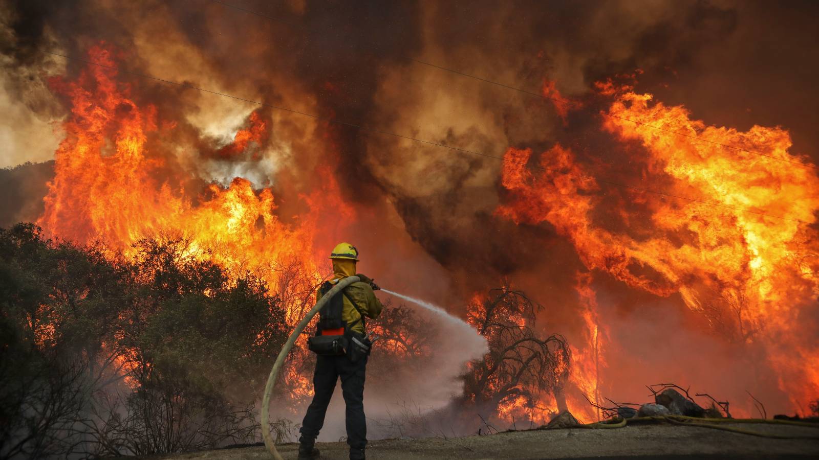
A record-breaking number of wildfires are blanketing the Amazon with smoke, choking some Brazilian cities and further isolating many Indigenous villages. Over 2,700 wildfires have been reported in the region in the first 11 days of the month — the highest number for any October since 1998, when the record-keeping began.
Air quality became so poor last week in places like Manaus that officials had to postpone the city’s annual marathon, and major universities canceled classes. Philip Fearnside, research professor at the National Institute for Research in Amazonia, said hospitals in the city are full of people who are having respiratory issues. “That should be a wake up call to actually change government policies and individual behavior to actually contain global warming,” he said.
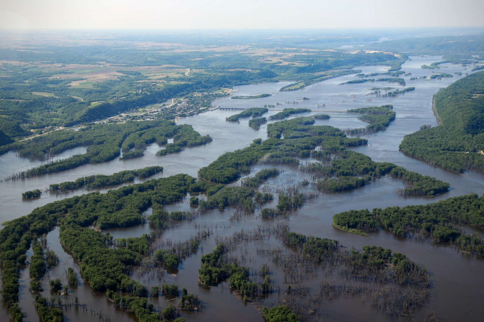
Part of the issue is that the Amazon is in the middle of a severe drought. Water levels in the region’s major rivers have become so low as to be unnavigable, leaving many Indigenous river communities without any way to obtain certain foods, drinking water, or medicine, according to Reuters. Commercial shipping has also been impacted as vessels from the Denmark headquartered company Maersk suspended service in Manaus, after a barge ran aground on the Rio Negro river last month.
“It’s a very worrisome situation,” said Marcia Macedo, an associate scientist at the Woodwell Climate Research Center. “We’ve seen large fish kills [an event in which numerous dead fish are suddenly observed in a body of water], water levels dropping way faster than normal — lake levels, river levels, like 6 meters below what would be expected at this time of year. And definitely the potential for it to get a whole lot worse before it gets better.”
On Wednesday, Indigenous tribes in the region called for the Brazilian government to take more formal action. “We ask the government to declare a climate emergency to urgently address the vulnerability Indigenous peoples are exposed to,” read a statement from the Indigenous umbrella group APIAM, which represents over 60 Amazonian tribes.
As of Friday, almost all of the 62 cities in the state of Amazonas, which includes Manaus, had declared a state of emergency.
Tree loss is not the only factor contributing to the current crisis. Climate change as well as El Niño, a weather phenomenon which results in a mass of warm water traveling east over the Pacific and crashing into South America, are also driving dry conditions. “Deforestation contributes to global warming, although fossil fuels globally are the main cause,” said Fearnside. “But global warming is changing climate all over the world, including here in the Amazon.”
El Niño, climate change, and extreme heat
El Niño is a natural weather phenomenon that fuels above-average global heat and more intense natural disasters in parts of the world. It is characterized by warmer-than-normal sea surface temperatures in the eastern Pacific Ocean. The hottest years on record tend to happen during El Niño.
The planet’s weather over the past three years has been dominated by El Niño’s opposite extreme, La Niña, which has had a cooling effect on the globe. Even so, the past eight years were the hottest in recorded history, the result of the warming effects of climate change.
Now, in conjunction with accelerating climate change, El Niño means a wide array of exacerbated hazardsmay be coming down the pike. El Niño’s impacts differ by region but can range from extreme rainfall to severe drought and increased wildfire risk.
Macedo warns that if the cycles that maintain the Amazon rainforests trademark wet, rainy, cloudy conditions start to dissipate, the forest could be permanently altered
“If you get beyond a certain amount of deforestation, you start to affect that recycling of rainwater back to the atmosphere that helps to kind of cool the land surface and also seed new rain clouds,” she told Grist. “If fires get out of control, then you have less forest cover and these droughts are even more intense and so on and so forth.”
While the system is fairly well understood, Macedo says it’s difficult to pin down at what point things will stop working as usual.
“It’s not linear. It’s not it’s not a simple process to kind of pin down,” said Macedo.
Indigenous food systems and traditional land management techniques are the best options for tackling ecological restoration. However, outdated scientific models and conservative views on environmentalism has led many researchers to overlook and discount traditional ecological knowledge held by Indigenous peoples. That’s according to a new study in Frontiers.
Researchers from the Indigenous Ecology Laboratory at the University of British Columbia, and the Historical-Ecological Research Laboratory at Simon Fraser University looked at two restoration efforts in St’at’imc and Quw’utsun territories and outlined a method known as “pop-up restoration” employed by environmental NGOs, extraction industries, and government agencies that offers prescriptive techniques to restore and heal land without considering local, Indigenous scientific practices. Pop-up restoration, the authors suggest, comes from deeply rooted misconceptions of Indigenous livelihoods and knowledge due to long-standing, deeply ingrained prejudices and racist ideas.
According to the researchers, pop-up restoration, or restoration initiatives that don’t make their restoration goals and impose inequities on unceded and stolen lands, often overlooks traditional
food systems and Indigenous histories.
In the report, the authors assessed two disturbance-restoration cycles and the ways Indigenous food systems approach restoration ecology and Indigenous land— especially when restoration erases longstanding land management and stewardship efforts.
“An Indigenous food systems lens provides a holistic approach to food production, distribution, and consumption, that centers humans’ coexistence with other living beings and prioritizes a cultural-ecological equilibrium over exploitation or fixed restoration goals,” wrote the authors.
The first example comes from St’at’imc territory in British Columbia, where St’at’imc voices were ignored by the government, hunters and ranchers while providing traditional knowledge for the restoration of lands devastated by a wildfire.
In June 2021 a heat dome in the region created record-breaking temperatures resulting in 619 heat related deaths and creating extreme fire conditions over much of the Pacific Northwest eventually leading to the McKay Creek Wildfire which burned about 85 miles of forest.
facilitating communication between affected Indigenous and settler communities, the Canadian government and ranchers. The St’at’imc Nation were given the opportunity to take part in the committee, and share their ideas on the best ways to restore the land.
But during the restoration process, government-led wildfire recovery in the region was largely driven by the values, goals, and priorities of only a few interest groups. Ranchers wanted to reseed much of the landscape with crop species that would introduce non-native plants, reducing native vegetation needed for the survival of mammals, birds and other wildlife – many of which are relied on by the St’at’imc Nation.
“We observed how government policy and decision-making overlooked, and in some cases outright dismissed, St’at’imc voices, knowledge, and expertise at the table,” wrote the authors.
“Non-Indigenous hunter and rancher interests seemed to be given priority over St’at’imc values, goals, and priorities, especially when those interests were at odds.”
The authors highlight that the settler colonial history in the St’at’imc region began in the late 1850’s with the Fraser River Gold Rush, which led to the establishment of cattle farming on the forests and grasslands in the area. The clearing of land for cattle, introduction of invasive species through fodder, wildfire suppression, the ownership of land by settlers and the removal St’at’imc peoples from their lands resulted in damage to the region, which helped the McKay Creek wildfire, the climate and the St’at’imc people.
Overall, the authors of the study said acknowledging the effects of past and ongoing waves of colonialism, being genuinely open and flexible to evolving community needs, being familiar with past failures and wrongdoings, and understanding and having compassion for the varying levels of interest, knowledge, resources, and skills for supporting land healing initiatives are important to the redevelopment and maintenance of lands.
“Results suggest that applying an Indigenous food systems lens to ecological restoration may provide a tangible framework for resolving some of the issues faced in top–down colonial policies common in pop-up restoration contexts,” the authors wrote.
This story is co-published with Arizona Luminaria and is part of The Human Cost of Conservation, a Grist series on Indigenous rights and protected areas. This transcript has been edited for length and clarity.
On a breezy spring day, Lorraine Eiler, a member of the Hia-Ced O’odham tribe, walked with me around the border of Quitobaquito Springs — a strawberry-shaped oasis in the Sonoran Desert near Pima County, Arizona. Her family has lived in the area for generations.
“If you do research on Quitobaquito, the majority of times you will read about the cattlemen that lived here in the area, about the people that went through Quitobaquito,” she said. “You hear nothing about the fact that it’s an old Indian village. It was abundant. Now, it’s just … well, you see what it looks like.”
The first thing you notice most about Quitobaquito Springs is the trees. It’s the only source of water for miles in the desert and the lush vegetation around it is stark against the dry tan and khaki landscape and occasional organ pipe cactus. The second thing you notice: the border wall, 30 feet tall, just feet from the water’s edge. I asked Eiler how the landscape compares to her early memories of the site.
“Barren,” she said, “very, very barren.”
For thousands of years, people have used Quitobaquito as a place to trade, to grow food, and to rest. The springs also provided water for animals in a region where it’s hard to come by. Quitobaquito’s springs are still sacred to O’odham people today and several of Eiler’s relatives, for example, are buried here.
“It has always been a place of refuge, a place of survival for anybody and anything that’s ever crossed through that territory,” said Amy Juan, a member of the Tohono O’odham Nation and the Tohono O’odham Hemajkam Rights Network, a collective of college students and youth focused on issues impacting Tohono O’odham peoples.
In the 1900s, the springs and the surrounding area were selected by the U.S. government for conservation and given one of the highest levels of environmental protection in the world. But today, Quitobaquito’s sacred springs are drying up. So what went wrong?
Quitobaquito Springs is part of the O’odham people’s traditional homelands — especially the Tohono and Hia-Ced O’odham nations. Before it was part of a National Park, before Arizona became a state in 1912, and even before there was an international border, the springs were really more like a marsh. Water flowed into the wetlands, feeding the gardens of squash, corn, and melons in the middle of the desert.
But settlers, warfare, and political decisions in the 1800s dispossessed the O’odham of their lands and carved the region into pieces. First, the U.S.–Mexico border split O’odham communities, separating families and cutting people off from their lands. Decades later, the U.S. government seized O’odham lands by congressional act, and, without a treaty, pushed the Tohono O’odham onto a reservation. Meanwhile, lawmakers created more policies intended to protect Quitobaquito’s fragile ecosystem. In 1937, President Franklin Roosevelt used the newly claimed lands surrounding Quitobaquito Springs to create Organ Pipe Cactus National Monument.
In the early days of the National Park Service, parks were mostly created with entertainment, sightseeing, and aesthetic beauty in mind. The agency believed that these areas should be kept wild, and protected from human interference.
But what they missed was that places like Quitobaquito were already a product of thousands of years of human maintenance — and that the park still had people in it. For instance, the Oroscos, a Hia-Ced O’odham family, were living in Quitobaquito Springs at the time when the park was created. They stayed in the area long after many tribal members were pushed out.
The family’s animals, buildings, and machinery didn’t match the agency’s vision of a wild, peopleless park. Finally, after decades of pressure, the National Park Service purchased the land for $13,000, bulldozed the Oroscos’ home, dug out a bigger collecting pond for water from the spring, and built a parking lot nearby to attract visitors.
“There was this idea that you would take the people out of living in these protected spaces, but they could come and they could visit and they could enjoy the natural environment, and we would protect that environment up to an extent,” said Rebecca Tsosie, an attorney and professor at the James E. Rogers College of Law at the University of Arizona. “But Indigenous presence is vital to the stewardship of the land.”
Without livestock to graze by the water’s edge, cattails invaded the pond, decreasing water flow. The decrease in water flow led to sediment build up, and in 1962, that increased sediment prompted park officials to dredge the pond. But dredging made the water too deep and too cold for the Sonoyta pupfish, one of the two endangered species endemic to the area. This forced the Park Service to build a kind of shelf in the pond so the fish could live in warmer waters.
At the same time, the nearby parking lot meant visitors had easy access to the water, and one park visitor released a golden shiner into the pond — a fish so well suited to the springs it started outcompeting the pupfish and driving it toward extinction. Once park officials realized this, they removed the pupfish, poisoned the pond to get rid of the golden shiners, refilled the pond, and then put the pupfish back in.
On a recent visit to Quitobaquito, I managed to spy a few pupfish — brown slivers of movement in the shallow waters of the springs. Tyler Coleman, a biologist and researcher with the National Park Service, told me that one of the biggest threats to the species today is low water levels. Ever since the 1990s, which saw a long term drought in the region, Quitobaquito has been drying up.
“So the little water that is produced in the Sonoran Desert is really valuable,” he told me. He pointed to the main springhead, a trickle of water which he described as a crack in the side of the mountain. “Any amount lost is going to be a problem.”
The decline of the springs has been attributed to drought, climate change, and the expansion of nearby farming that taps into the natural underground aquifers.
Then the border wall came.
In 2020, the U.S. government began building the controversial wall along the U.S.–Mexico border, 30 feet high, that cut across the entire southern edge of the park. Crews drilled for groundwater near the declining springs that they used to make cement.
“Unfortunately, during that period of time, the water levels started going down and the pond itself right in the center just became dry, which was something new,” Eiler said.
It’s not entirely clear if border wall construction caused water levels to drop. And we may never know, because the Trump administration waived all environmental assessments in the name of national security.
“The United States has some of the best environmental laws of any nation in the world,” said Tsosie. “But on the border, they wanted a full-scale, speedy construction of the border wall. So they bypassed all of those things.”
In 2022, the Park Service relined the pond, with support from the International Sonoran Desert Alliance, a nonprofit organization that Lorraine Eiler works with. People from U.S. government agencies and the Tohono O’odham nation worked to delicately scoop the turtles and pupfish into holding tanks until the lining was replaced and the pond was refilled.
But restoration is ongoing and it’s not yet clear whether or not these efforts will restore water levels — or how long that fix will last.
“Whatever was here is gone,” Eiler said. “We can try to make it. We’ll never get to the point of what it used to look like. And it all depends on water.”
Around the world, in the face of biodiversity loss and climate change, there are calls to expand protected areas like Quitobaquito — though, as the springs show, a designation doesn’t guarantee protection. Last December, 196 countries agreed to “30×30,” a global goal to conserve 30 percent of the world’s lands and waters by 2030. The U.S. has its own version of that project, called “America the Beautiful.” Many of the areas targeted for protection under these policies are in Indigenous territories or on lands integral to Indigenous peoples’ livelihoods, and many have not sought consent from those communities or integrated their knowledge or practices in protection plans.
“I think a lot of the border violence, a lot of the impacts on the Tohono O’odham, those are invisible when you’re visiting [Quitobaquito],” Tsosie said. “That cultural landscape is part of the environmental landscape. And we need to steward that and protect it and care for it just as we do those endangered species.”
Amy Juan agrees that Quitobaquito needs to be protected, but from a country that has caused more harm to the springs than good, not from the people who have cared for it for generations.
“Sometimes it feels out of our hands,” she said. “But what we can control and what we can continue to do is make sure that we maintain these traditions, these ceremonies, these connections, because once we let go of them, once we lose them, once we don’t maintain them, that just continues to hurt who we are as O’odham. We’re desert people. We have to take care of all these things that make us who we are.”
The lavvu is set up in the traditional way: three, debarked birch rods holding up a cloth exterior. The lavvu, a traditional Sámi structure that resembles a teepee or a tent, is insulated with reindeer skins, and in the center, on a floor of twigs, a hearth. Typically a fire would be burning, but for now, a plant stands.
Traditionally, one doesn’t stand inside a lavvu save to enter and sit, so Mihkkal Hætta, the 22-year-old Sámi organizer from the village of Kautokeino, Norway, gestured to me to sit on the soft reindeer pelts.
“Welcome,” said Hætta. “I’ve been staying here for three weeks now.”
With the door closed, fresh air circled through the dwelling from an opening at the top of the lavvu. It was remarkably quiet inside, and soothing.
Outside stood the Norwegian Parliament. Street musicians busked for tourists, scooters and cars flew by, and dog walkers filed past Hætta’s temporary home. A cluster of Sami youth and other environmental-activists also gathered. Curious passersby stopped to ask what was going on. Most asked what a lavvu was doing on official government property.
“I came here on September the 11th because it’s been 700 days since the Supreme Court ruled in favor of [the Sámis from Fosen],” Hætta would explain. “It’s quite unbelievable that a state like Norway lets human rights violations continue for 700 days. And it’s still ongoing.”
Hætta said most people from Oslo who come to the lavvu say they support him, but in the early days of his protest, there were several incidents: a rock band tried to break in one night and another time, someone stole some of his clothing.
Hætta’s presence in Oslo is becoming a familiar one – as are his comrades, and their attempts to bring attention to the Fosen case. On October 11, 2021, Norway’s Supreme Court ruled that the Fosen wind farm near the city of Trondheim, on the nation’s central-west coast, violated the rights of Sámi reindeer herders, the cultural rights of the Sámi people, and were constructed illegally.
Now, on the eve of the two year anniversary of the court’s ruling, Hætta’s one-month protest serves as a reminder that despite Norway’s international renown for human rights advocacy and standards, Indigenous peoples inside the country’s borders still have no recourse to justice.
“I became really angry, losing more and more hope and losing more and more faith with the government,” said Hætta. “So I decided to put up a lavvu here outside the Norwegian Parliament to remind them that this is still ongoing.”
While Hætta’s protest has gone on for a full month, he’s not alone and it’s not his first. By night, allies and friends look out for him, taking turns on night watch shifts outside the lavvu to keep him safe. And with the exact anniversary of the court ruling only one day away, more and more supporters are arriving to support, with buses coming from Sámi villages and communities across Sápmi — the traditional territory of the Sámi stretching from Russia across northern Finland into Sweden and Norway.
“I’m never alone here,” he said. “I couldn’t do this if I was alone. I have a lot of people around me.”
Hætta first became involved with the Fosen case earlier this year. On February 23, exactly 500 days after the court’s ruling, the Norwegian Sámi Association’s Youth Committee, also known as NSR-N, began occupying the Ministry of Petroleum and Energy in protest of the Norwegian government’s inaction after the verdict. Hætta took part.
During the protest, nearly 30 demonstrators, including Hætta, were arrested and another 90 removed from the Ministry’s property by police. Over the course of a week, Sámi youth organizers were joined by land and rights defenders from Young Friends of the Earth Norway, Greenpeace, Greta Thunberg and nearly 2,000 additional supporters. Human rights campaigners eventually shut down 10 ministries and ended their protest outside Norway’s royal palace.
In the wake of the actions, the Minister of Petroleum and Energy delivered an official apology to reindeer herders in Fosen and acknowledged that the wind park constituted a human rights violation, while the Sámi Parliament of Norway demanded the windmills be demolished and the area restored to reindeer grazing land. Instead, however, Norwegian officials have attempted to negotiate with reindeer herders in order to keep the Fosen wind park operational.
Much of the energy produced at the $1.3 billion Fosen wind park will be part of Norway’s green transition – approximately 98 percent of the country’s electricity comes from renewable sources. However, in 2021, almost 17 percent of that electricity was exported to other European countries. There are nearly 53 wind farms operating, or under construction, in Norway right now and it’s estimated that another 100 licenses have been granted by the government with many slated for construction in Sápmi.
“By failing to enforce a judgment by its highest Court, the Norwegian government is denying the rights of Indigenous Sámi to their cultural heritage and livelihoods,” said Carla Garcia Zendejas, Director of the Center for International Environmental Law’s People, Land and Resources Program in Geneva, Switzerland. “Sámi leaders should not need to put themselves at risk to ensure that effective justice is carried out. Not only does this cast a shadow on the Norwegian government’s commitment to upholding human rights obligations, it questions the rule of law.”
In June of this year, Hætta marked 600 days of inaction by joining with NSR-N and Motvind Norge, an organization that opposes the construction of wind turbines on conservation grounds, to demonstrate outside the Norwegian Parliament again, while activists blockaded the entrance to the wind park at Fosen.
Recently, 24-year-old cultural worker Emily Cottingham from Tønsberg and 26-year-old Daniel Fuller were guarding the lavvu. Fuller, who is Irish-British, works at a nearby cafe and became involved when he began offering coffee to Hætta and other activists outside the Parliament.
“I have always been interested in decolonisation, having studied this,” said Fuller. “When I saw that Mihkkal moved into the lavvu, I realized that it was time to put my theory into practice”.
Then there’s Israel Nebeker, an American musician from Oregon who has come to Norway to trace his Sámi roots. When Nebeker heard about the Fosen case, and the actions taking place, he extended his trip.
“It feels important to be at this demonstration, to show my support for the Sámi at Fosen, and to hold the government accountable to its own laws,” said Nebeker. “It’s time for the government of Norway to protect the rights of Sámi, instead of continuing a history of brutal injustice.”
In 1981, Sámi organizers began demonstrations in Oslo to protest a proposed hydroelectric dam in Sápmi. Known as the Alta Action, Indigenous leaders occupied a government building and began hunger strikes. While efforts were unsuccessful in stopping the dam from being built, the moment marked a major turning point in Indigenous resistance in the region.
“When my father lived in Oslo as a young man, he attended the Alta demonstrations,” said Nebeker. “The Sámi have been fighting for far, far too long.”
Demonstrations are expected to begin tomorrow as more human rights campaigners make their way to Oslo. Sámi people that have worn Gaktis, traditional clothing, are wearing them inside out – an old Sámi tradition that communicates protest. When Sámi people turn their Gaktis inside out, it signifies resistance.
“It’s completely despicable for a country like Norway to ignore its own courts and laws,” said Hætta. “It’s a human rights violation and it’s been going on for 729 days.”
The justices of Brazil’s Supreme Court voted 9-2 last week against a legal framework that would have made it impossible for Indigenous tribal leaders to reclaim traditional land and that would have eased the way for more mining, agriculture and other extractive industries on that land.
The ruling sets a precedent for hundreds of acres of Indigenous land claims and is expected to have a widespread impact on Indigenous land rights.
The legal thesis at the heart of the case, known as marco temporal, had been moving through the courts since 2007 and was overwhelmingly endorsed in the nation’s conservative-dominated lower congressional house.
It involved a legal interpretation of Brazil’s 1988 constitution, which gives Indigenous people the right to claim lands they “traditionally occupied.” Since the adoption of the constitution in 1988, more than 700 Indigenous territories have been claimed. To date, 496 have been officially recognized, or demarcated, by the government, which defines property boundaries and guarantees the possession of the land and the exclusive use of its natural resources to the Indigenous peoples who live on it.
The theory would have limited tribal claims to territories they were occupying or legally disputing on the day the constitution was ratified. However, due to the Indian Statute of 1973, Brazil gave Indigenous people the same legal status as children, meaning they didn’t have standing to represent themselves in the state’s legal system — including in land matters.
The ruling marks the end of the yearslong fight that grew intensely under former President Jair Bolsonaro. Over the last four years, deforestation in the Amazon rose 56 percent with an estimated 13,000 square miles of land destroyed by development. During that time, Indigenous peoples lost an estimated 965 square miles of their traditional territories due to Bolsonaro’s policies.
Brazil’s right wing, agribusiness sectors and other industries such as developers, loggers, miners, and farmers with business interests in Indigenous lands, including the Amazon, have supported the effort. Many proponents cited economic development as a key reason to support the idea — particularly for soybean production, cattle farming, and mining.
President Luiz Inácio Lula da Silva took office in January and pledged to protect existing lands and create new territories. In recent months he has made climate and the environment central to his agenda. In August, his administration unveiled infrastructure investment programs and other initiatives that he pitched to start Brazil’s green transition.
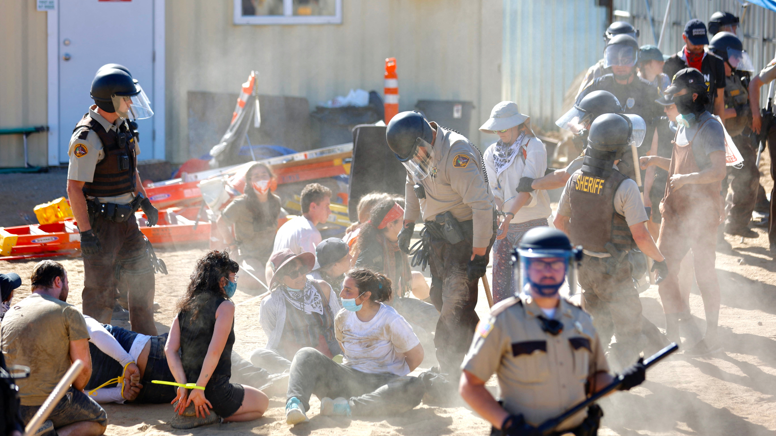
In a ruling last week, a Minnesota judge summarily dismissed misdemeanor charges against three Anishinaabe water protectors who had protested at a pipeline construction site in an effort to stop the Enbridge Line 3 tar sands oil pipeline. “To criminalize their behavior would be the crime,” she concluded.
Judge Leslie Metzen relied on a rarely-used Minnesota statute that allows a judge to dismiss a case if doing so furthers “justice.” She assessed that in this case justice meant throwing out charges against Anishinaabe people committed to preserving their treaty lands. “The court finds that it is within the furtherance of justice to protect the defendants peacefully protesting to protect the land and water,” she wrote.
“I’ve never seen a judge dismiss a case in the name of justice,” said Claire Glenn, a staff attorney at the Climate Defense Project who was part of the defense team for the water protectors. She said that research undertaken by the legal team found very few cases where the statute had been cited previously.
The three defendants, Tania Aubid, Dawn Goodwin, and Winona LaDuke, were emotional as they processed the ruling during a press conference on Monday. Each member of the trio faced a range of charges — including trespass, harassment, public nuisance, and unlawful assembly — for their participation in a protest in January 2021.
“Judge Metzen proved that treaties are the supreme law of the land, and we have every right to protect for future generations,” said Goodwin, who also goes by Gaagigeyaashiik and is a White Earth tribal member.
LaDuke, however, argued that the system was not strong enough to keep their people’s land and water safe. Since the completion of the pipeline in 2021, regulators have revealed that Enbridge punctured aquifers at least four times during construction.
“The regulatory system and legal systems are not equipped to deal with the violence of the ecological crimes underway,” LaDuke, former director of the nonprofit Honor the Earth, said. As she sees it, the water protectors had no other recourse than to participate in a months-long series of protest actions meant to halt the project.
As the Center for Media and Democracy and Grist laid out in a recent investigation, Enbridge reimbursed sheriffs’ offices, the Minnesota State Patrol, the Department of Natural Resources, and even a public relations officer for work related to quelling the protests, funneling a total of $8.6 million to various agencies through an escrow account created by the state Public Utilities Commission.
According to police reports, a group of 200 protesters blocked traffic on a rural Minnesota road on January 9, 2021, as they marched toward a place where a backhoe was holding a large pipe near a freshly dug hole. Twenty or 30 people entered the pipeline construction site, stopping work. “A Native American woman I did not know, wearing a jingle dress did a dance on the edge of the trench, and would not move back,” wrote Aitkin County Investigator Steve Cook. Police issued dispersal orders, and the protesters cleared out soon after, the reports conclude.
An officer on the ground pointed to Aubid and LaDuke as potential leaders, and another investigator identified Goodwin after reviewing Facebook videos. But the trio only received citations weeks later — five misdemeanor charges for Aubid and LaDuke, and three for Goodwin.
It would be months before Enbridge reimbursed law enforcement agencies for the hours they spent policing the protest. According to an analysis by the Center for Media and Democracy, at least four local law enforcement agencies received more than $17,000 from Enbridge for assigning nearly 40 officers to the protest site that day.
“It was not necessary to have 40 or 50 police officers at any point,” LaDuke said. “This was excessive force used upon all of us — excessive prosecution, and it was incentivized by Enbridge.”
About two weeks after the protest, Enbridge machinery quietly punctured an aquifer at a similar Line 3 construction site. Over the next year, a total of more than 72 million gallons of water spilled from the earth. The Minnesota Department of Natural Resources forced the company to pay $3.2 million in environmental penalties. However, a single misdemeanor was the only criminal charge Enbridge faced, and it came with a deal that said it would be dismissed after a year.
The aquifer breach was key to the defense attorneys’ argument for dismissal of the charges. At a settlement conference the day before the decision, Joshua Preston, who represented Goodwin, asked the judge to put the case in perspective.
“We just experienced the hottest summer globally on record, a documented fact that led the United Nations Secretary General to issue a statement on September 6 stating ‘climate breakdown has begun,’” he said. “Why does Enbridge get one charge while my client gets three?”
“This is the question history will ask if the state is allowed to move forward in its prosecution,” Preston continued.
At the press conference, Frank Bibeau — who is Anishinaabe and a longtime attorney for pipeline opponents — said that such arguments are typically ignored when they come from Indigenous people: “These are words we say all the time, but they never get heard.”
Prosecutors filed a total of 967 criminal cases against people attending Line 3 protests. The vast majority were dismissed, some for lack of probable cause, others via negotiated agreements. Not everyone has avoided “guilty” verdicts. In the last three months, two were convicted of felonies for participating in protests. Glenn said those cases involved prosecutorial misconduct that is still being litigated. Fewer than 20 open cases remain.
In a number of cases, attorneys attempted to argue that the involvement of the Enbridge escrow account means the arrests violated pipeline opponents’ rights to due process. However, these arguments failed to sway any judge.
Preston’s arguments about his clients’ case’s relation to the climate crisis, on the other hand, found a receptive audience in court. “These cases and these 3 defendants in particular have awakened in me some deep questions about what would serve the interests of justice here,” Metzen, the judge, wrote in a memo attached to the ruling.
“Their gathering may have briefly delayed construction, caused extra expense to law enforcement who came to clear their gathering (much of which was reimbursed by Aitkin County through Enbridge), but the pipeline has been completed and is operating in spite of their efforts to stop it through peaceful protest,” she continued. “In the interest of justice the charges against these three individuals who were exercising their rights to free speech and to freely express their spiritual beliefs should be dismissed.”
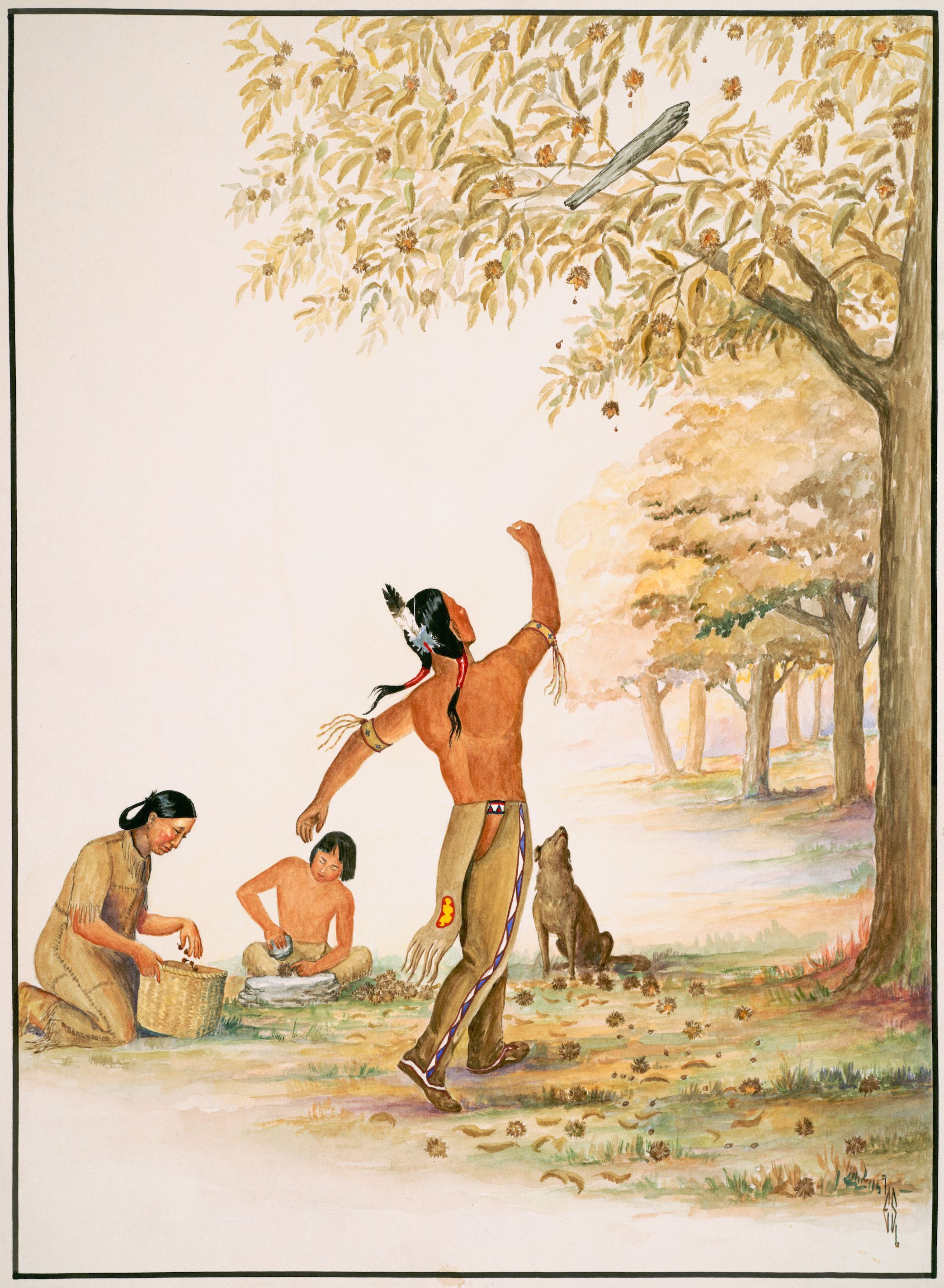
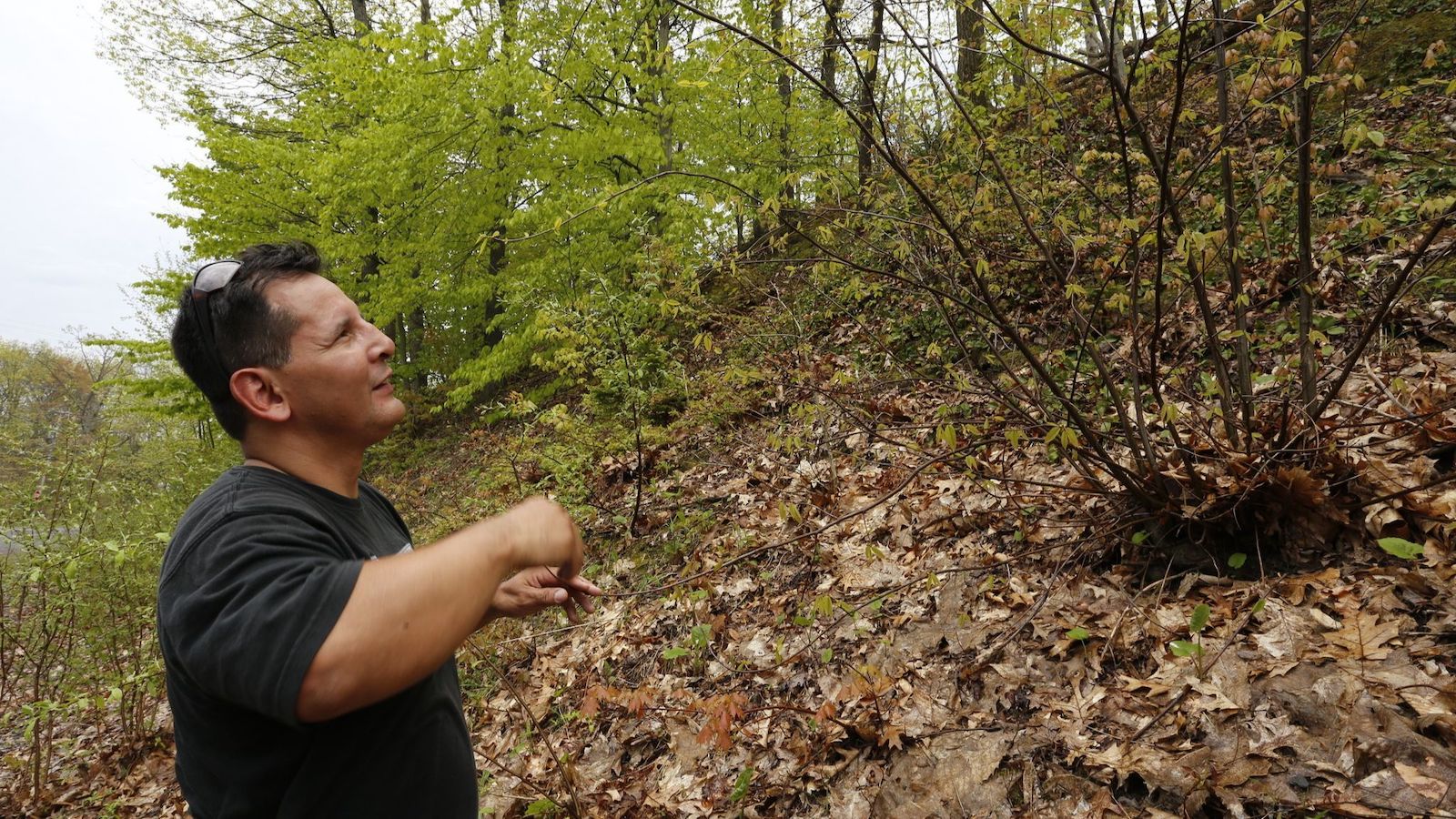
When Neil Patterson Jr. was about 7 or 8 years old, he saw a painting called “Gathering Chestnuts,” by Tonawanda Seneca artist Ernest Smith. Patterson didn’t realize that the painting showed a grove of American chestnuts, a tree that had been all but extinct since his great-grandparents’ time. Instead, what struck Patterson was the family in the foreground: As a man throws a wooden club to knock chestnuts from the branches above, a child shells the nuts and a woman gathers them in a basket. Even the dog seems engrossed in the process, watching with head cocked as the club sails through the air.
Patterson grew up on the Tuscarora Nation Reservation just south of Lake Ontario near Niagara Falls. The painting reminded him of his elders teaching him to harvest black walnuts and hickories.
“I think, for me, it wasn’t about the tree, it was about a way of life,” said Patterson, who today is in his 40s, with silver-flecked dark hair and kids of his own. He sounded wistful.
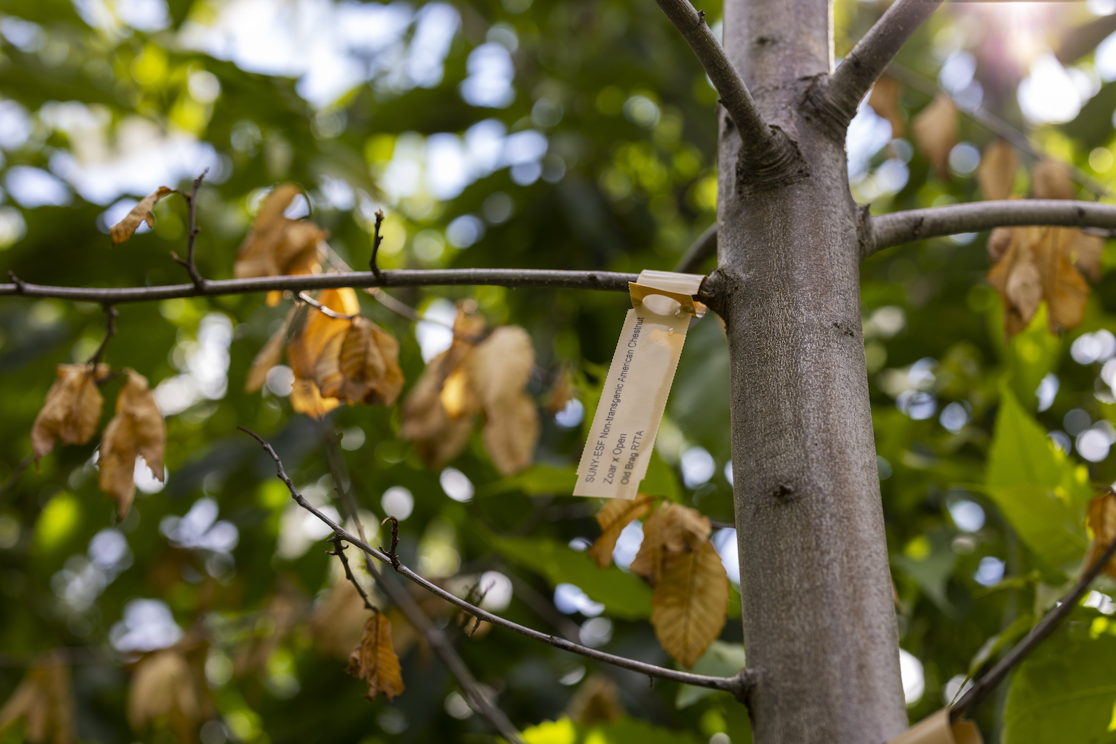
“Gathering Chestnuts” watercolor by Ernest Smith (Tonawanda Seneca, Heron Clan), 1938. Courtesy of the RMSC. Rochester, N.Y.
The American chestnut tree, or číhtkęr in Tuscarora, once grew across what is currently the eastern United States, from Mississippi to Georgia, and into southeastern Canada. The beloved and ecologically important species was harvested by Indigenous peoples for millennia and once numbered in the billions, providing food and habitat to countless birds, insects, and mammals of eastern forests, before being wiped out by rampant logging and a deadly fungal blight brought on by European colonization.
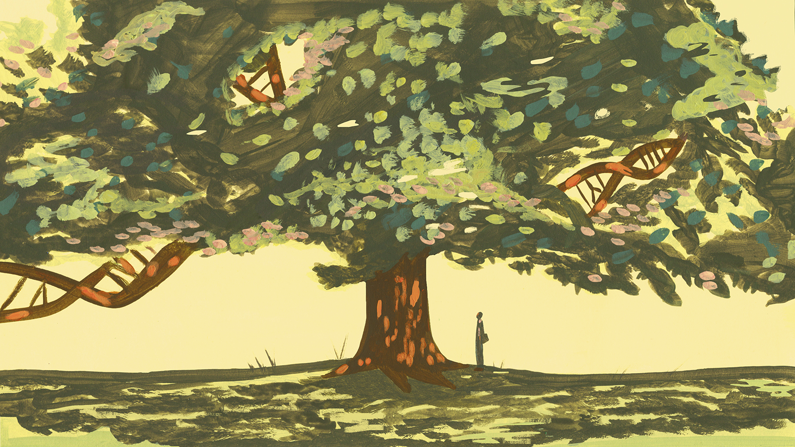
Now, a transgenic version of the American chestnut that can withstand the blight is on the cusp of being deregulated by the U.S. government. (Transgenic organisms contain DNA from other species.) When that happens, people will be able to grow the blight-resistant trees without restriction. For years, controversy has swirled around the ethics of using novel biotechnology for species conservation. But Patterson, who previously directed the Tuscarora Environment Program and today is the assistant director of the Center for Native Peoples and the Environment at the State University of New York’s College of Environmental Science and Forestry in Syracuse, has a different question: What good is bringing back a species without also restoring its traditional relationships with the Indigenous peoples who helped it flourish?
That deep history is not always clear from conservation narratives about the blight-resistant chestnut. For the past four decades, the driving force behind the chestnut’s restoration has been The American Chestnut Foundation, a nonprofit with more than 5,000 active members in 16 chapters. Before turning to genetic engineering, the foundation tried unsuccessfully to breed a hybrid chestnut that looked and grew like an American chestnut but had genes from species native to Asia that gave it blight resistance. “Our vision is a robust eastern forest restored to its splendor,” reads The American Chestnut Foundation’s homepage, against a background of glowing green chestnut leaflets. “Our mission is to return the iconic American chestnut to its native range.”
But the Foundation website’s history of the tree begins during colonial times, suggesting a romantic notion of a precolonial wilderness that ignores the intensive agroforestry that Indigenous peoples practiced. By engineering vanished species to survive harms brought on by colonization without addressing those harms, people avoid having to make hard decisions about how most of us live on the landscape today.
Two unmodified, open-pollinated American chestnut burs, left, grow near hand-pollinated, genetically modified samples, in bags at right, at the State University of New York’s College of Environmental Science & Forestry Lafayette Road Experiment Station in Syracuse in 2019. Adrian Kraus / AP Photo
Bill Powell began working on chestnut genetics when he was a 28-year-old graduate student in Utah, which is actually outside the tree’s natural range. Now in his late 60s, with silvery hair, glasses, and an infectious curiosity about the relationship between tree and pathogen, he’s a leading chestnut restoration expert.
When I met Powell in 2022, he fretted that the chestnut restoration process was taking too long. “Unfortunately, I see retirement on the horizon,” he told me. “But not anytime soon, because I have to get this done.” At the time, Powell was a colleague of Patterson’s, working for the same university and directing the American Chestnut Research and Restoration Project. Since then, as the blight-resistant tree has wound its way through the deregulatory labyrinth of federal agencies including the Environmental Protection Agency, Food and Drug Administration, and Department of Agriculture, Powell has had to step down, recently sharing his diagnosis of terminal colon cancer publicly.
When we spoke, Powell stressed that after the blight-resistant chestnut is deregulated, no Indigenous nations will have to grow the transgenic trees on their lands if they choose not to. But he acknowledged that this does not reassure those who think of Indigenous land not in colonial terms, meaning within reservation boundaries, but instead in terms of treaty rights or cultural practices on historic tribal lands. Indigenous nations, including members of the Haudenosaunee Confederacy such as the Tuscarora Nation, have long argued that even when they ceded land to colonial governments, they did not cede their rights to access and care for plants and animals on those lands.
Bill Powell, stands in a lab at the State University of New York’s College of Environmental Science & Forestry in 2019. Adrian Kraus / AP Photo
The nuts of the American chestnut are small, sweet, and nutritious. They were an important part of the varied diet that sustained Patterson’s ancestors for millennia; in return, people cared for groves of the trees across thousands of miles. When the United States pushed Indigenous peoples throughout the chestnut’s range off their lands, and the American chestnut became functionally extinct, an ancient reciprocal relationship vanished, too.
“We were instructed to pick those nuts,” Patterson said. “And when we don’t pick them, the plant goes away.”
With craggy bark and shaggy branches of feathery leaves, the American chestnut could reach 100 feet tall during its heyday. Its trunk could be 13 feet wide. The trees huddled along the Gulf Coast for some 8,000 years during the most recent ice age, sheltering in the relatively warm stretch from Florida to the Mississippi River, because mountain peaks even in the southernmost part of the Appalachians were too cold for chestnut trees to grow. Then, as the snow receded northward 20,000 ago, the trees slowly migrated from their coastal refuges. They worked their way up the Appalachian Mountains — helped by Indigenous peoples, whom they helped in turn.
The trees dropped an avalanche of chestnuts to the forest floor each year. According to historian Donald Edward Davis, people burned low fires that dried the nuts and killed off chestnut weevils. By suppressing other plants, fires helped the chestnut trees spread, and the nuts became staples of Indigenous diets — a reliable source of nutrition that people stored in earthen silos or pounded into flour for chestnut bread and other foods. The human-tended groves also fed animals such as elk, deer, bison, bears, passenger pigeons, panthers, wolves, and foxes. Chestnut logjams in streams created deep, clear pockets of water where fish could thrive. Several species of invertebrates relied on chestnut trees for habitat; after the trees died out, five species of moths went extinct.
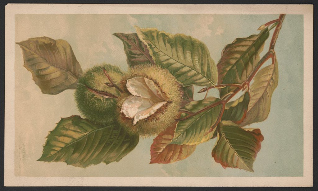
An 1885 print from L. Prang & Co. shows the American chestnut (Castanea vulgaris, var. Americana). Library of Congress
European settlers forced Indigenous peoples along the chestnut’s range from much of their homelands, severing access to plants and animals they’d long interacted with. Meanwhile, settlers cut down chestnuts for many reasons — to clear space for towns and farms; to build fence posts, telegraph poles, and railroads; or just to gather the nuts more easily.
Nevertheless, the chestnut survived for centuries. Enslaved people gathered chestnuts to supplement meager meals and to sell. White Appalachian communities came to rely on chestnuts as free feed for their hogs and other livestock, and as a cash crop.
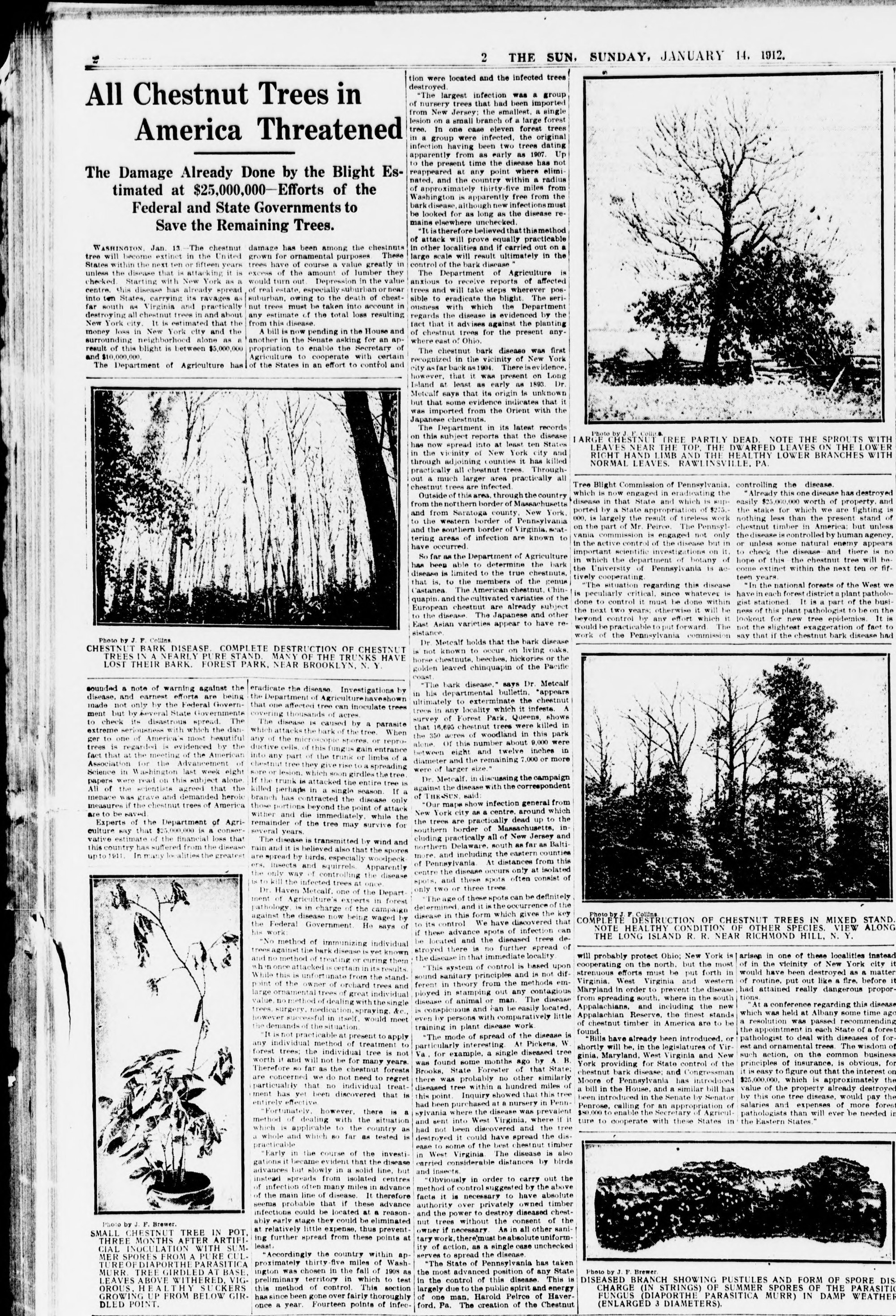
Then, in the late 1800s, horticulturalists imported trees carrying the fungal blight Cryphonectria parasitica to the United States. The blight spread by wind and splashing rain; it also hitched rides on insects and birds. Once it landed on the bark of a new tree, it dug in through weak spots — old burn injuries, insect wounds, or scars left from woodcutting — and dissolved the tree’s living tissue with oxalic acid, creating angry orange streaks and open cankers on trunks. The trees would die back to their roots, resprout, and die back again, like botanical zombies. The blight killed at an astonishing pace. All told, a tree whose ancestors evolved millions of years ago died out in less than 50 years.
A 1912 article from the Sun describes the American chestnut tree blight. Courtesy of The New York Public Library, Astor, Lenox and Tilden Foundation / Library of Congress
In turn, the chestnut lost the people whose practices helped it thrive. Patterson told me that some Indigenous nations even lost their word for the chestnut tree, because chestnuts disappeared at the same time that the U.S. government took Indigenous children, including at least one of Patterson’s own relatives, and placed them in boarding schools. In part, this was another strategy for coercing tribes to give up territory. Many children didn’t survive the schools, which were often run by Christian organizations. Those who did were forced to give up their languages, religious beliefs, and traditions. But chestnuts still inhabit Indigenous creation stories and religious calendars, and Patterson believes that a reciprocal relationship can be reestablished between Indigenous nations and the tree. He’s just not convinced that releasing the transgenic chestnut will restore those connections.
The Tuscarora Nation, of which Patterson is an enrolled citizen, is one of six Indigenous nations that today comprise the Haudenosaunee Confederacy, also known as the Iroquois Confederacy. The Haudenosaunee creation story, Patterson said, is “a cycle of loss, grieving, and recovery all the time, just like ecological succession.” By creating a genetically engineered chestnut, Patterson argues, scientists are avoiding the part of the cycle where people grieve and learn from their mistakes.
On the timescale of Haudenosaunee history, the losses still feel new. “It’s been 100 years — but that’s not long,” Patterson observed. Then he reconsidered. “That’s long for research scientists, or a plant technology innovator. It’s too long.”
To Patterson, what’s not being restored — treaty rights to access and care for plants and animals on the landscape — is telling.
“If you want to restore this, like, ‘primordial’ forest, don’t you also want to restore our relationship with that forest?” he asked. “Like — what’s your relationship to a transgenic chestnut?”
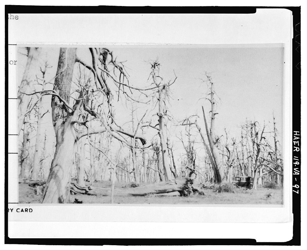
An undated archival photo shows a grove of blighted American chestnut trees in Page County, Virginia.
Library of Congress
By the time Patterson first saw Ernest Smith’s artwork in the early 1980s, the Tuscarora Nation was going through a cultural renaissance. Patterson’s mother made her children speak Tuscarora at home to keep the language alive. His family and other Haudenosaunee community members participated in political acts such as the occupation of Alcatraz Island by Indigenous people from across the U.S., in part as a response to post-World War II termination policies aimed at curtailing tribal sovereignty and revoking territory. Murals on the walls of Patterson’s state-run elementary school showed Tuscarora people hunting, fishing, trapping, and gathering, even as non-Indigenous people contested those traditional activities outside of reservation lands, from the local to the national level.
Over time, Patterson was taught that the Haudenosaunee Confederacy never ceded its “reserved rights,” or rights that are not explicitly mentioned in treaties or court cases. Today, the Confederacy maintains that it still holds rights to care for and access the species growing on its ancestral homelands and in ancestral waterways — even in territory ceded to settlers. But both the state of New York and the federal government have chipped away at those reserved rights through court cases, and often won. In this legal context, harvesting chestnuts, like the family in Smith’s painting, is not only a cultural practice; it’s an exercise of tribal sovereignty.
Neil Patterson studies a small chestnut, right, in the woods outside Syracuse. The main trunk has been killed by blight, but the roots keep sending out shoots. Julia Rosen / Los Angeles Times
Patterson works to rebuild tribal access to many plants and animals that are culturally important for Haudenosaunee peoples. Because those plants and animals often live outside of reservation lands, his work can be difficult. New York State maintains that, except on reservation lands, Indigenous peoples have the same rights as non-Indigenous peoples, and have to follow the same regulations regarding when, where, and how much they hunt, fish, or gather, such as hunting seasons or fishing licenses — regulations the Tuscarora have been fighting in court for decades. So to Patterson, the question of whether to grow transgenic trees isn’t really the most urgent one. He’s more concerned about upholding a way of life that restores traditional ecological relationships.
“Aside from the whole issue of being transgenic, this is just about access and care of place,” he told me. In New York’s state lands, he added, there are almost no provisions for gathering medicines, collecting food, or growing food in traditional territories. Yet that reciprocity helped chestnuts spread and thrive across thousands of miles and thousands of years.
The Haudenosaunee Confederacy began making treaties with white settlers more than 400 years ago. The two-row wampum belt, made of rows of white beads run through with two rows of purple beads, documents a 1613 agreement between the Haudenosaunee and Dutch settlers to live in parallel, not interfering with each other’s ways of life. In 1794, during George Washington’s presidency, the Haudenosaunee and the United States signed the Treaty of Canandaigua, affirming the Confederacy’s sovereignty on its territory. In the Nonintercourse Act, a series of statutes passed in the late 1700s and early 1800s, Congress also barred states from purchasing lands from Indigenous nations without federal approval. When states’ land purchases are approved, Indigenous nations don’t lose any other rights on those lands, such as hunting, fishing, or gathering, unless the treaty specifically cedes those rights, explained Monte Mills, who directs the Native American Law Center at the University of Washington.
Nonetheless, states including New York still try to assert control over tribes or tribal resources, and in many cases, succeed. In one 2005 case, Patterson himself was the defendant, charged by the state of New York for ice fishing without properly labeling his gear. Patterson brought a copy of the Treaty of Canandiagua to court, explaining to the judge that as a member of the Haudenosaunee Confederacy, he had the right to fish in the state park, formerly Seneca territory, without regulation by the state of New York. Patterson lost that case.
The Supreme Court of the United States has also limited Haudenosaunee reserved rights, though from a different angle. In City of Sherrill v. Oneida Indian Nation of New York, decided just a few months before Patterson’s case, the Supreme Court ruled that although the Oneida Nation, which is part of the Haudenosaunee Confederacy, never gave up certain rights on its ancestral land, it had essentially waited too long to exercise them.
This particular case centered around whether tribes had to pay local and state taxes on ancestral land that they bought back on the real estate market. In the majority opinion, Justice Ruth Bader Ginsberg wrote that both Indian law and the need to treat people equally “preclude the Tribe from rekindling embers of sovereignty that long ago grew cold.” According to Mills, the Supreme Court essentially said that Oneida had let too much time pass to assert its sovereign rights, and therefore had lost them.
“It’s one of the worst decisions from foundational Indian law court,” Mills said. Although the case was about property taxes, Mills said that it could be a precedent for preventing Indigenous nations from exercising reserved rights. “The state would probably point to Sherrill and say, ‘No, you can’t have those rights, because you haven’t asserted them for so long,’” he added.
But Mills also pointed out that sometimes, tribes and states have been able to work together to come up with mutually beneficial ways for tribes to exercise their reserved rights. If states are interested in recognizing tribal sovereignty, he said, there are models out there for how to do it.
For its part, the state of New York has been working recently to improve its relations with Indigenous nations. In 2022, the state and the federal government agreed to return more than 1,000 acres to the Onondaga Nation. That same year, Governor Kathy Hochul’s administration created an Office of Indian Nation Affairs in the Department of Environmental Conservation, the same department that 20 years previously ticketed Patterson and fought him in court over reserved fishing rights. Peter Reuben, who is enrolled in the Tonawanda Seneca Nation, is currently serving as the first director of the new office.
To Reuben, the creation of his position by the department “really shows that they are serious about us,” he said. Reuben is working to create a productive and respectful consultation process between the region’s Indigenous nations and the state of New York on environmental issues, and to hash out agreements over hunting, fishing, and treaty rights.
“If it’s in the state’s interest — which it seems like it would be — to have more support and additional resources for natural resource management, then why not work with tribal folks to support a program where they’re able to continue to do what they said they’ve been doing all along?” Mills said. “It’s probably going to lead to a better end result anyway.”
Holly Stapleton / Grist
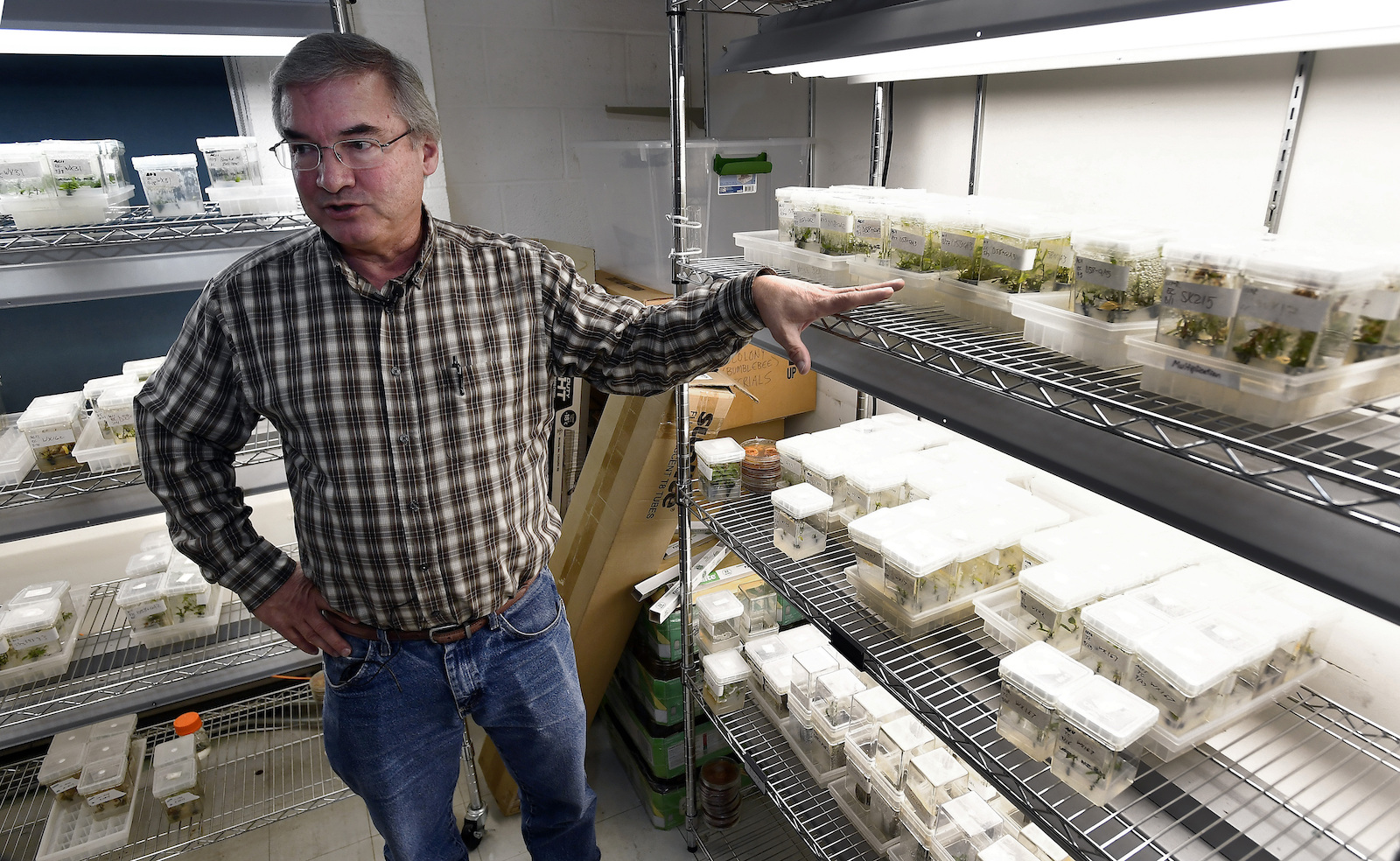
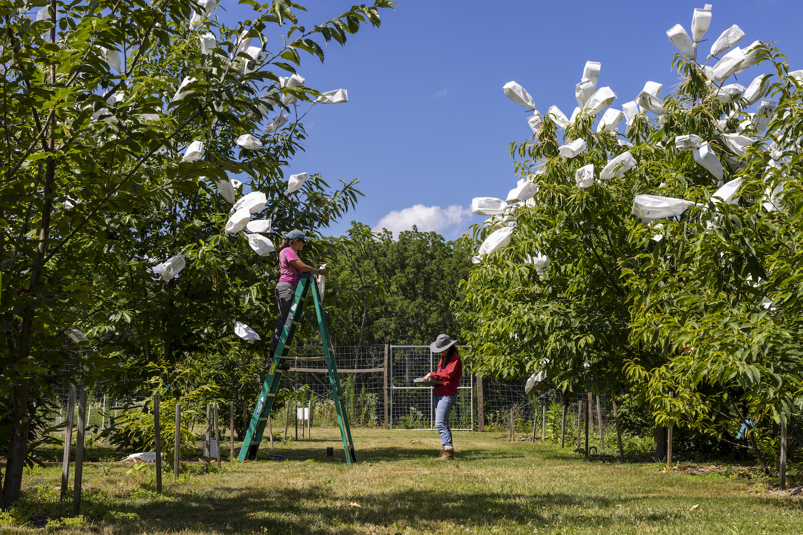
For now, while transgenic American chestnut trees are still highly regulated, one of the best places to see one is at the Lafayette Road Experimental Field Station on the southern outskirts of Syracuse. Powell met me there on a sunny July morning two summers ago.
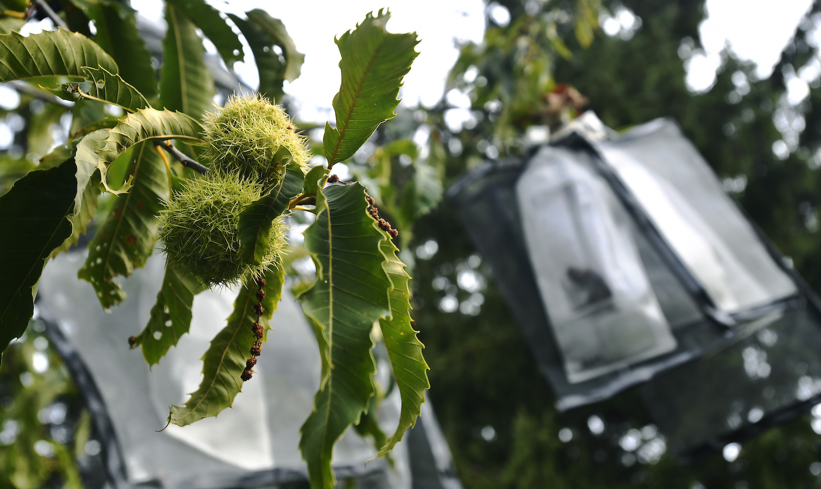
On fields that glowed bean-pod green in the upstate humidity, thousands of chestnut trees grew in varying stages of reproduction, healing, and death. White paper bags festooned the taller trees, their flowers covered to manage fertilization.
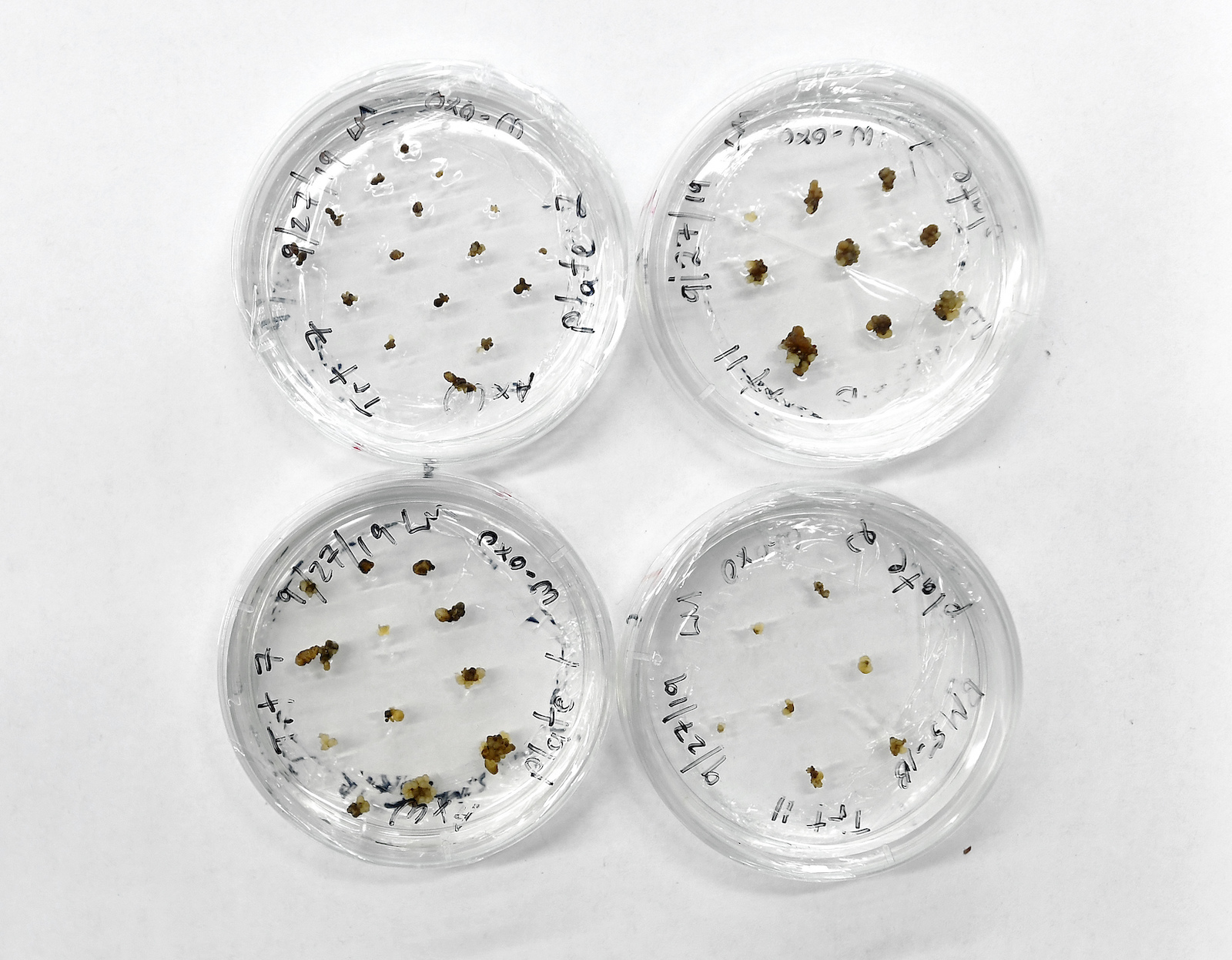
The transgenic chestnuts contain wheat DNA that lets the tree create an enzyme that fights off Cryphonectria parasitica, the fungal blight. The blight cankers on these trees don’t grow big enough to girdle them.
Rows of strappy transgenic saplings, some as tall as Powell, waited in holding plots fenced to keep out hungry deer. “We’re planting them on very close spacing, and we can only hold them for about three years, and then they get root-bound,” Powell said. As the permitting process drags on, time is running out to replant these young trees.
A lab manager records data while a student researcher pollinates flowers on an American chestnut tree at a field research station in Syracuse in July 2022. Lauren Petracca / The Washington Post via Getty Images
I asked Powell why he thought restoring the chestnut was important. Chestnuts produced a stable crop of nuts for wildlife, because they flowered late enough in the year that they escaped flower-killing frosts, he said. “It was just an important part of our ecosystem, and for our heritage, too,” he added. “The railroads that were made in the East used ties that were made out of chestnuts because they were rot resistant. And people used to say, chestnuts used to follow you from cradle to grave, because the wood was used in everything from cradles to coffins.”
Although he’s retired, Powell is working to create a research center that would develop transgenic versions of other native species going extinct from blights, insects, and other introduced pests. He imagined growing transgenic versions of everything from elms, killed off by Dutch elm disease and the elm yellows pathogen, to ash trees, which are currently being devoured by iridescent green beetles called emerald ash borers.
People who hope to use technology to resurrect extinct species, whether the American chestnut or even the woolly mammoth, are sometimes considered ecomodernists. According to Jason Delborne, who studies biotechnology and environmental policy at North Carolina State University (where I previously worked, in the English department), “There are people who are environmentalists at their core, but sick of losing, and interested in the promise of technology to solve the ecological and environmental problems we are facing.” Part of that interest, he said, comes from a sense of responsibility to “fix what you broke.”
Dead leaves hang on a non-transgenic American chestnut tree, caused by a blight canker further down the trunk, at a field research station in Syracuse in July 2022. Lauren Petracca / The Washington Post via Getty Images
Indeed, Jamie Van Clief, the southern regional science coordinator for The American Chestnut Foundation, explained to me that she got interested in working for the organization because her field, environmental science, was depressing.
“There’s a lot of disaster, there’s a lot of dismay, and to have this foundation with such a positive and impactful mission just attracted me immensely,” she said. “To be able to work towards something when it kind of feels hopeless sometimes — and to be part of restoration on the scale that we’re doing — is incredible.”
As Powell and I gazed at a diseased, non-engineered chestnut sapling, its yellowing leaves hanging limp in the sun, I reflected that eastern forests weren’t exactly flush with any other giant trees. Almost all old growth has fallen to human endeavors. Conservation efforts also have to take into consideration climate change, which may shift suitable chestnut habitat north into Canada — and shift plant diseases’ habitats as well. Root rot, or Phytophthora cinnamomi, is another introduced pathogen. It only infects chestnuts in the South right now, because root rot dies during winter freezes. The American Chestnut Foundation estimates root rot will spread to New England in the next 50 years as the region warms. Plus, there are few places available for a new chestnut forest to grow, except perhaps forest remediation sites such as old Appalachian coal mines. The fact is, releasing blight-resistant chestnuts into the wild won’t guarantee them a landscape where they can survive.
Because biotechnology alone can’t restore the American chestnut to the numbers that its supporters are envisioning, Powell anticipates relying on citizen scientists. After deregulation, he imagines The American Chestnut Foundation sending transgenic pollen to interested people, who could pollinate the flowers of wild mother trees growing nearby. They could plant the nuts the trees grow or pass them on to other chestnut fans.
Genetically modified chestnut embryo clusters are stored in a lab at the State University of New York’s College of Environmental Science & Forestry in Syracuse. Adrian Kraus / AP Photo
The health and ecological risks of introducing the transgenic chestnut into the wild are likely to be low, according to Delborne; its signature wheat gene is commonly found in many major food crops. But at heart, Delborne argues, the debate isn’t just about chestnuts. “It’s also about a category of technology that could find its way into the world,” he said.
Even if the chestnut recovery doesn’t work out, the approval of the engineered chestnut for unregulated growth could open the door to a new era of biotechnology in U.S. forestry — such as a pest-resistant poplar tree, which kills forest insects by expressing genes from the bacterium Bacillus thuringiensis, and already grows commercially in other countries.
The debate about blight-resistant chestnuts isn’t really about trees or even genetic engineering; it’s about who gets to make decisions on the land. Conservation is framed in European cultures as an objective goal, but it’s a worldview that other people may not share, explained Katie Barnhill-Dilling, a North Carolina State University social scientist who researches environmental decision-making. “Some of the people I’ve talked to from the Haudenosaunee Environmental Task Force would contest that humans are here to accept the gifts as they are now,” she said.
Some Indigenous nations in the chestnut’s historic range, such as the Eastern Band of Cherokee Indians, or EBCI, and the Seneca Nation of Indians, are considering growing genetically engineered chestnuts on their reservation lands after the trees are deregulated. To EBCI Secretary of Agriculture and Natural Resources Joey Owle, restoring the American chestnut is another way for the tribe to exercise its sovereign rights, more than a century after the tree’s disappearance.
“It’s one project of many projects that we work on to enhance our sovereignty as a tribe, to work to establish a culturally significant resource that provided a bountiful harvest for our ancestors and wildlife,” he said. “It’s just cool to be part of it.” Based on feedback from EBCI committee members, Owle said that planting transgenic trees, while an option, is the “last option that we would like to pursue” to restore the species. For now, the EBCI is scouting out wild chestnuts that survived the blight, and planting hybrid trees on its land in partnership with The American Chestnut Foundation.
Holly Stapleton / Grist
On a crisp fall day a couple of years ago, Patterson and Powell arranged for around 15 people to gather chestnuts in upstate New York. The grove grew on a hilly slope on state land that used to be an agricultural field. “It was just a beautiful little spot,” Patterson recalled. The 12 or so American chestnuts were young; Patterson estimated they were perhaps 20 years old and no more than 25 feet tall.
The group, a mix of Haudenosaunee Confederacy members and non-Indigenous scientists, toted assorted equipment to gather the prickly nuts: ladders, homemade pickers, plastic buckets, sturdy leather shoes, and gloves. But first, they stood in a circle in the grove and discussed the future of the American chestnuts. According to Patterson, things quickly became adversarial.
Powell and Patterson had long been collegial: Patterson first tasted an American chestnut after he microwaved some that Powell handed him in the campus building where they both had offices. Meanwhile, Powell’s students learned from Patterson about the parallel expulsion of Indigenous peoples from their lands and the disappearance of chestnut trees.
Powell has constantly reached out to tribes for input and to understand their perspectives, Patterson said. And unlike other biotechnology researchers, Powell has focused on technology for environmental restoration, not for personal profit. “I admire the idea that this is about technology for restoration — whatever that is,” Patterson added.
But their relationships with plants remain fundamentally different. For example, Powell has talked about keeping the price of the transgenic chestnuts low, just to raise enough money to cover the costs of getting them out to people. In contrast, when I asked Patterson why he never bought or sold seeds from traditional food plants for his home garden, he sounded incredulous. “That’s like selling people,” he said. “That’s life. … Why would you sell somebody?”
That fall day, Patterson began worrying that if the restoration succeeds and transgenic chestnuts grow across the land, releasing pollen into the wind, people won’t be able to tell transgenic trees apart from non-transgenic trees. Scientists in the group assured everyone that in the future, people would be able to tell the trees apart through genetic testing.
“It was this privileged standpoint, which is, ‘Well, technology will figure it out for us.’ But it’s not as if I’m going to hand that technology to my son or nephews or my grandsons before they go off to gather,” Patterson said. “It just seemed like it was so simple to them.” He wondered why the non-Indigenous scientists and conservationists had been able to plant this grove on state land in the first place, when his nation was largely prevented from accessing or caring for plants there.
The group got tense. “The conversation turned to fear, and to moral opposition,” Patterson recalled. Patterson realized this standoff wasn’t the right frame of mind for the trip. “Well,” he exclaimed, “let’s go pick some nuts!”
As he collected chestnuts, Patterson couldn’t help but think of Ernest Smith’s painting. “It was a fulfillment of that scene,” he told me. Patterson reflected on his ancestors, wondering how they’d gathered the prickly nuts without his contemporary tools. He felt that by collecting chestnuts, he was doing what he was supposed to do. He hoped that in the future, he’d be able to find more wild chestnuts and organize more gathering trips, taking care to bring Haudenosaunee kids along. But he could see that the masting trees were struggling with the blight and weren’t going to survive much longer. Some of the young trees were already more than half dead, leaves brown and wilted.
He and his wife, who also attended the trip, were struck by a realization: If the federal government deregulated the blight-resistant trees, letting their pollen float freely through the air, this trip might be one of the last times they could gather wild American chestnuts with certainty.
A new study found trace amounts of nuclear waste in sea turtles in the Marshall Islands and five locations in the continental United States, underscoring the enduring legacy of nuclear testing and weapons development.
The analysis, published in the journal PNAS Nexus, looked at turtle and tortoise shells at locations tied to nuclear testing including Southwestern Utah, the Oak Ridge Reservation in Tennessee, the Savannah River Site in South Carolina, and the Barry M. Goldwater Air Force Range in Arizona.
Cyler Conrad, an archaeologist at the University of New Mexico who led the study along with 22 other researchers, said the team found evidence of uranium radionuclides in the shells of turtles and tortoises at all five sites. He added that contamination amounts were so small that it’s doubtful the animals experienced health impacts.
“If you take a paperclip and divide it a million times, if you take a millionth piece of that and divide it another million times, that’s about the same quantity that we’re measuring in some of these shells,” Conrad said.
Still, Conrad says the findings are significant because they illustrate how turtles and tortoises, in part due to their long lives and metabolic processes, are able to retain nuclear contamination in their tissues. According to Conrad, turtle shells grow in a sequential style, similar to tree rings, and record isotopic elements such as uranium-236 from spent nuclear fuel.
The study is the first that Conrad knows of that identifies nuclear contamination in turtles in the Marshall Islands, but it’s far from the first to find evidence of historical, military-related pollution in wildlife there. In 2019, a U.S. Army study found dangerous levels of polychlorinated biphenyls, more commonly known as PCBs, and arsenic in fish around Kwajalein Island in the Marshalls, which has served as a U.S. military base for decades and is currently part of the Ronald Reagan Ballistic Missile Defense Test Site.
The paper also builds upon decades of research illustrating how nuclear waste bioaccumulates in sea creatures. Conrad said the study’s methodology of analyzing shells is new, but noted past studies have found previous evidence of radionuclides in turtles. A 2020 study of sea turtles in the Montebello Islands found contamination of turtle eggs and tissues.
The findings coincide with Japan’s decision to release treated, contaminated wastewater from the Fukushima Daiichi nuclear power plant into the Pacific Ocean. The move prompted China to ban seafood from Japan, inspired protests in Fiji and South Korea and has particularly frustrated Indigenous peoples in the Pacific who have spent decades fighting against the dumping of nuclear waste in the region. Between 1946 and 1958, the Marshall Islands were the site of 67 U.S. nuclear tests, leading to health and environmental harms that the Indigenous people of the islands continue to grapple with.
Conrad hopes the study inspires more research into turtles and tortoises and how they record nuclear history.
“They’re taking in all of this information, they’re depositing this, and they’re acting as a really critical library for us to be able to reconstruct the history of the world in different ways,” Conrad said. “They’re experiencing what humans are experiencing and they’re able to record this in a very unique way.”
Danity Laukon was sitting in her bedroom in her two-bedroom flat in Suva, Fiji when she got the call. It was November 2021, and her dad, more than 1,800 miles away at her home in Majuro in the Marshall Islands, had died after a battle with diabetes.
He was 50 years old.
Diabetes is not an illness that is directly caused by radiation. But Laukon believes that American nuclear testing in the Pacific played a role in his early death.
After years of nuclear bomb detonations in the Marshall Islands, fallout and forced relocations of communities began a ripple effect: many Indigenous Marshallese people who had relied on subsistence farming and fishing for 4,000 years suddenly couldn’t trust the safety of their food, becoming reliant on imported products, and unhealthy, non-native processed foods.
And those were the lucky ones. On Utrik atoll, where Laukon’s maternal family is from, many residents fell ill from acute radiation sickness.
Now she’s worried her community will face even more health risks. On Thursday, the government of Japan began releasing wastewater from the wrecked Fukushima Daichi nuclear plant into the Pacific Ocean, and plans to continue to do so gradually for the next 30 years.
An observatory room at Tokyo Electric Power Company Fukushima Dai-ichi nuclear power plant shows (from left) unit 1 to unit 4 reactor buildings and storage tanks for contaminated water.
BEHROUZ MEHRI / AFP via Getty Images
Japan is treating the water before it is poured into the sea, but the water will still contain low levels of radioactive contaminants that can’t be removed. Japan promises that the levels of contaminants present will be significantly lower than international health standards, and has gained the support of a key United Nations agency. But some scientists remain concerned about how little is known about potential long-term effects of the wastewater.
Japanese officials declined to speak on the record about their plans but have publicly outlined an argument that the country is running out of room to store contaminated water from the nuclear power plant and that another earthquake – similar to the quake that damaged the plant – could release the stored water before being treated. The plan now is to treat contaminated water, then dilute it into the Pacific Ocean over the course of three decades in order to more quickly decommission the nuclear facility.
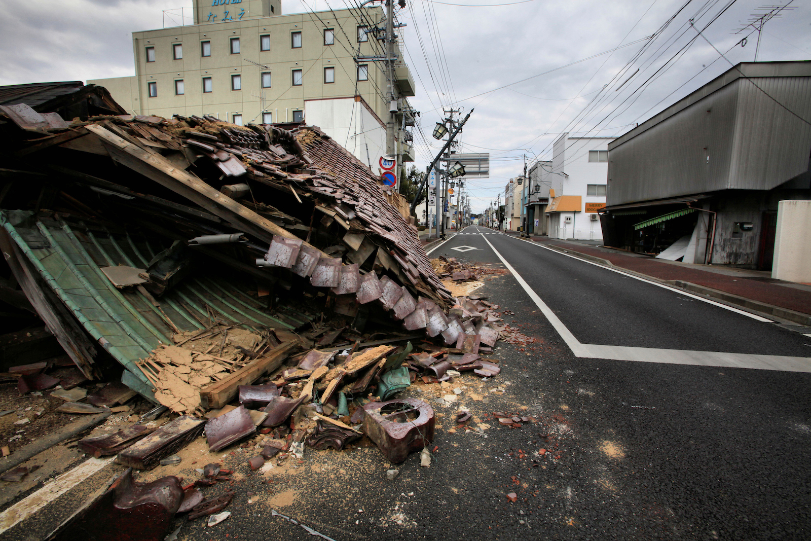
In 2011, a 9.1-magnitude earthquake struck Japan causing a tsunami that killed more than 19,000 people and knocked out emergency generators to the Fukushima nuclear plant. In the hours after, three nuclear reactors melted down, forcing the evacuation of more than 100,000 people. Radioactive water spilled into the Pacific and was carried east by currents toward the United States. Two and a half years later, radiation from the plant was detected in waters off California, but at levels considered harmless.
A photo from April 2011 shows the “ghost town” of Minamisōma, a city located in Fukushima Prefecture. All residents were evacuated after an earthquake damaged the nearby Fukushima nuclear power plant on March 11, 2011.
Noboru Hashimoto / Corbis via Getty Images
In the decade since, Japan has erected more than 1,000 tanks to store more than a million tons of water from Fukushima: rainwater, groundwater, and water pumped into the facility to cool the damaged reactors. Once treated, that water will be poured into the Pacific for the next three decades.
Japanese officials have promised that the levels of contaminants present in the wastewater will be significantly lower than international health standards, and last month, the International Atomic Energy Agency, a United Nations agency that oversees nuclear energy, greenlit the plan when it released a report describing the wastewater as having a “negligible radiological impact on people and the environment.”
However, some scientists remain concerned about how little is known about potential long-term effects of that wastewater, while many Indigenous peoples in the Pacific, like Laukon, worry that the move will add an additional burden to the health disparities communities already face. For Laukon, Japan’s decision is an extension of a long-running history of using the Pacific as a dumping ground for nuclear waste.
“It’s giving us more to deal with,” she said. “It feels helpless.”
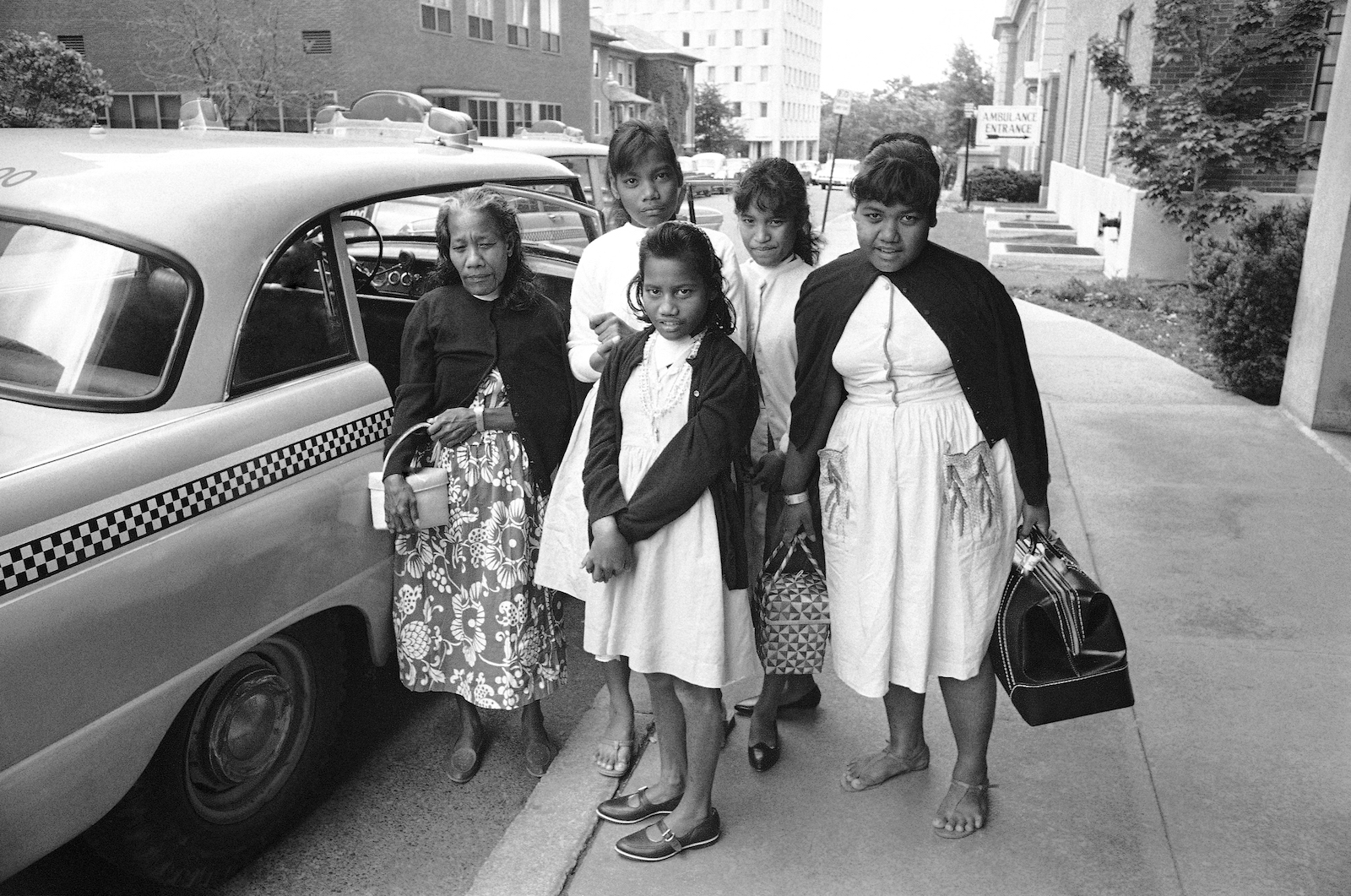
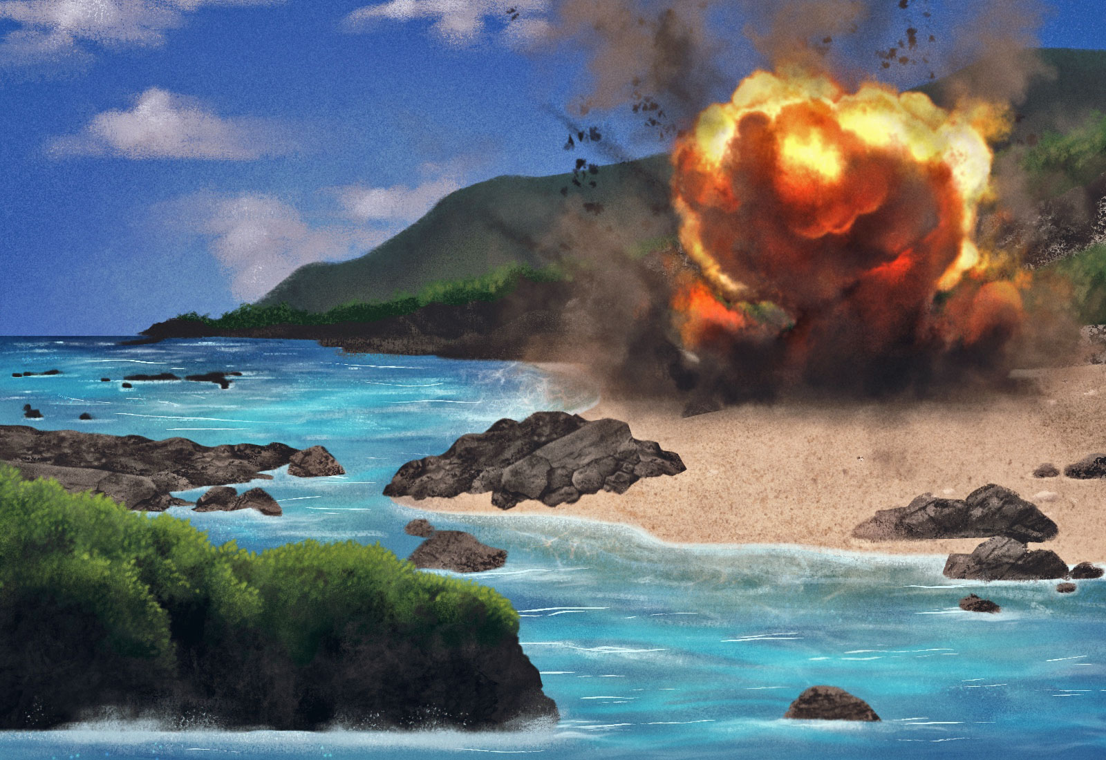
During the Cold War, Britain, France and the U.S. tested more than 300 nuclear bombs across the Pacific regions of Polynesia and Micronesia as well as in the deserts of Australia. After a detonation in the Marshall Islands, children on Rongelap atoll ate “snow” that fell from the sky that later turned out to be calcium debris from the fallout. Radioactive debris clung to the coconut oil of women’s hair.
Five Pacific islanders, left to right, Jonita Jalme, 15, Jemloch Kebinli, 14, Lisa Paul, 42, Mary Kebinli, 20, and Mina Boaz, 13, exposed to heavy radio-active fallout in 1954, pose before leaving New England Deaconess Hospital in Boston on June 11, 1966, where they recovered from surgery for removal of growths from their thyroid glands. The group were among the 64 residents of Rongelap atoll in the Marshall Islands who were showered with particles from an H-bomb test at Bikini on March 1, 1954.
FCC / AP Photo
At Fukushima, one concern about the discharge is around tritium, a radioactive isotope produced in nuclear reactors that can’t be removed through Japan’s treatment process. Japanese officials say that once the wastewater mixes into the ocean one kilometer off of Japan’s shores, the amount of tritium present is expected to be well below the World Health Organization’s standards for drinking water quality –1,500 becquerels per liter compared with the WHO limit of 10,000 becquerels per liter; levels comparable to those in water released from normally-operating nuclear power plants in China, the United Kingdom and Canada.
Japan says the discharge is safe, but Timothy Mousseau isn’t so sure. The biologist and professor at the University of South Carolina and author of an exhaustive review of existing studies on tritium currently awaiting publication.
“The bottom line from my perspective is that (tritium) has been insufficiently studied to be making hard promises about the long-term safety of this kind of release,” Mousseau said. “We don’t actually really understand what the potential ramifications of a massive point source of tritium will be on the natural environment.”
While exposure to tritium through swimming or drinking water isn’t a risk, the radioactive isotope can bioaccumulate through the food chain. Studies of mice and rats suggest that ingesting tritium could lead to cancer and fertility problems, Mousseau said, but whether that would happen in humans isn’t clear because the radioactive isotope hasn’t been studied enough.
“We really don’t know whether there will be a significant hazard to humans at the end of the food chain,” said Mousseau.
That potential to impact the food chain is a big concern to Robert Richmond, director of the Kewalo Marine Laboratory at the University of Hawaiʻi and a professor who specializes in marine conservation biology and coral reefs.
Richmond is part of a panel of experts advising the Pacific Islands Forum, the chief diplomatic body representing Pacific island nations, on Japan’s plan. In February, he visited Japan to meet with the country’s scientists about the release. He left unimpressed by the lack of data they provided regarding the contents of their water tanks and the effectiveness of their treatment system.
“When they say the science is impeccable — no, anything but,” he said.
Richmond and his fellow scientists saw red flags in what data did exist including inconsistencies and poorly designed sampling protocols. One of Richmond’s colleagues, Kenneth Buesseler, is a marine radiochemist and senior scientist at the Woods Hole Oceanographic Institution.
Buesseler says the water flowing through the plant is exposed to more radiation than cooling water in normally functioning nuclear reactors because it’s in direct contact with molten coil. That means the water will need to be treated multiple times to reach the health standards that Japan has promised. He doesn’t believe Japan has effectively demonstrated that its treatment system can consistently remove the high levels of dangerous compounds present in the wastewater.
He also doubts that there’s an urgent need to get rid of the water and says Japan should consider other viable alternatives. The rush to discharge the water, Richmond said, suggests Japan is choosing the cheapest, most politically expedient method to get rid of the nuclear waste rather than doing what’s best for its neighbors and the ocean, which is already stressed from the effects of climate change, plastic pollution and ocean acidification.
“Once you’ve made a mistake, there’s no turning back, and all the monitoring in the world does nothing to protect ecosystems or the people who depend on them,” he said. “It simply tells you when you’re screwed and that doesn’t really do anything.”
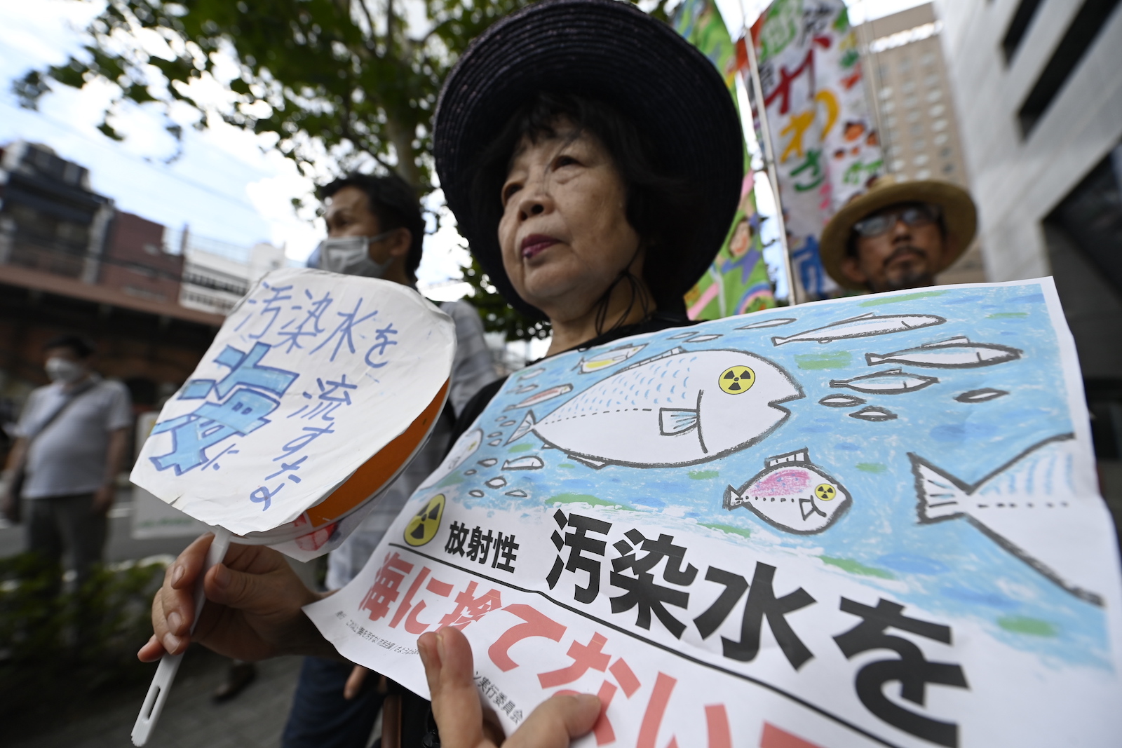
People gather on August 24, 2023, in front of Tokyo Electric Power Company to protest the release of stored nuclear-contaminated water from the Fukushima Daiichi nuclear power plant.
David Mareuil / Anadolu Agency via Getty Images
Pacific opposition to the plan was initially strong, but after Japanese officials carried out a multi-million dollar advertising campaign to sway public opinion including meeting with Pacific leaders, several expressed support, most recently Fiji Prime Minister Sitiveni Rabuka.
On Twitter on Tuesday, Rabuka called the comparison of Japan’s controlled wastewater discharge to historic nuclear testing in the Pacific “fear mongering.”
“It’s impossible to compare those nuclear tests with the careful discharge of treated wastewater from Fukushima over a period of approximately 30 years,” he wrote.
But other leaders, like Vanuatu’s foreign minister, remain unconvinced. Sheila Babauta, a former legislator from the U.S. Commonwealth of the Northern Mariana Islands, abbreviated as CNMI, authored a resolution that condemned Japan’s plan in 2021. Today, she remains resolute in her opposition.
“I’m deeply concerned for the people of the CNMI and how decisions by major world powers are being made without our knowledge and how that’s going to impact our lives today and for future generations,” she said.
On Tuesday, Laukon was visiting Honolulu, and woke up to Facebook messages from friends asking her about Japan’s plan to release the wastewater that week. What could they do? Could they put out a statement criticizing the plans? Would it make a difference?
It took her a while for the reality to sink in — the fact that what she and others had been campaigning against was actually happening.
“To be honest, it feels helpless to really voice what you want to say because does it matter? Are they listening?” she said. “But it does matter. Whatever we do now will still affect later generations. And that’s why I’m worried.”
It was hard to put how she felt into words. What could she say that could capture the feeling she had about what she feared, what this big decision that was so far out of her control meant for her people?
She finished composing a poem she had started writing last week in Fiji. It was about a turtle who lays eggs under the full moon, only to realize they won’t hatch.
“Under a full moon / I see raindrops / blue water / an island is grieving / in silence,” she wrote.
Forests managed by Indigenous nations are severely underfunded. To reach per-acre parity with forests managed by the Bureau of Land Management and the U.S. Forest Service, the federal government would need to increase funding by nearly $96 million every year. That’s according to a new report from the Intertribal Timber Council, a nonprofit consortium consisting primarily of tribes and Alaska Native Corporations.
In 2019, the base year for the study, tribal forests represented nearly 19 million acres in the United States, including approximately 10.2 million acres of commercial forests and woodlands. A total of 345 tribal forests are managed across the nation, with 316 of those forests being held in federal trust.
“It seems like a fairly straightforward answer that when we look at the disparity in funding between other federal agencies and tribes, that [Congress] would just increase appropriations,” said Cody Desautel, President of the Intertribal Timber Council and member of the Confederated Tribes of the Colville Reservation. “But that hasn’t been the case.”
According to the report, non-timber forest products are essential to many tribal communities. Traditional herbaceous plants are found within forested areas while fish, wildlife, roots, fungi and edible tree components such as sap, seeds and nuts, are harvested by communities for medicinal purposes and provide connection to lands.
“Indian forestlands are quite diverse across the country. But all have one thing in common, they are a lifeline for the tribes that live on these lands,” wrote the authors. “The tribal needs from their forests are diverse: forests provide everything from stumpage revenue to employment to harvesting game for subsistence, to being cultural and religious sanctuaries.”
Since 2013, Tribal Priority Allocations, or TPA, that provide federal funding for basic Tribal services, like ecosystem and landscape conservation, have been relatively stagnant despite rising costs for forestry management at the Bureau of Indian Affairs. Coupled with sub-par funding for other services, like law enforcement and healthcare, Desautel says much of that TPA funding is often dispersed to different departments, like education.
“Because of that lack of funding and staffing, we’ve got significant backlogs in work that should have been done over the previous decades,” said Desautel. “That puts our forests at worse health and higher risk or disturbance.”
The lack of funding has created limited staffing and issues around workforce capacity which have impacted tribal forest management. “Neither the BIA nor tribes have adequate funds to pay for staffing,” said the authors of the study. “In multiple visits the team was told that the annual funding from the Bureau has not increased in 20 or more years and is no longer a sufficient amount to pay salaries it was originally designed to.”
For tribes such as the Confederated Tribes of the Colville Reservation, timber revenue made up a large fraction of their revenue, at one point providing 80 percent of their yearly budget. “It paid for that tribal council, it paid for a police force, it paid for 80 percent of our staff,” said Desautel “It was hands down the most important resource we had to ensure that we had money to function as a tribal government.” However, he adds that a transition is being made by many tribes to find funding and revenue in other places.
The study’s authors also found that climate change, wildfires, and catastrophic natural events are causing unprecedented destruction at a massive scale, making the need for forest protection and conservation even more dire.
Carbon sequestration is gaining popularity across Indian Country as well, projects such as Fond Du Lac Band Of Lake Superior Chippewa, Keweenaw Bay Indian Community and Lower Brule have been embraced among tribes and have been used in commercial forest lands as sequester options. Indigenous forests, particularly in the Amazon rainforest are helping curb climate change. The world’s forests, which cover about 30% of Earth’s land, absorbed approximately 7.2 billion more tonnes of CO2 per year than they emitted between 2001 and 2021.
However, despite world leaders spending billions of dollars to protect forests, only 17 percent of global funding actually goes to Indigenous communities, like those in the United States. Desautel said government leaders must work with Indigenous peoples to provide better funding for tribal forestry.
“Tribes are vastly underfunded compared to other federal agencies, and we don’t think that should be the case,” said Desautel. “We also know that because of that lack of funding and staffing that we’ve got significant backlogs in work that should have been done over the previous decades. That puts our forests in worse health and higher risk of disturbance.”
I will never forget the first time I killed a tree. It was a warm January morning, and my forehead was sweating under my orange hardhat. I pulled the starter rope of my chainsaw, lifted the roaring silver blade, and sliced through a small Douglas fir. The tree barely made a sound as it fell.
With sawdust and the smell of fresh resin filling the air, I turned toward another fir and paused, wishing I knew a ritual to make its death easier. Within minutes, bits and pieces of seven trees lay strewn around me. I separated limbs from trunks and stacked them, hoping that orderly piles of firewood might alleviate my guilt.
I live in coastal Sonoma County, California, where Douglas firs grow faster than most other native trees, eventually shading oaks from sun and often killing them. The trees near my cabin are valley oaks, the largest of American oaks, found only in California. Each of them can live up to 600 years and will drop as many as 3 million acorns during its lifetime, making valley oaks the most important source of food and shelter for wildlife. I wanted to protect these ecological linchpins, but I also picked up that chainsaw three years ago to repay a childhood debt.
I love all trees, but I’m especially moved by oaks. One of my earliest memories is of hiding in the roots of a particularly majestic one as my parents fought and neighbors called the police. I remember its large, sturdy trunk protecting me from the wind, rain, and fear of violence. That tree still stands in southeastern Latvia, where I spent most of my life until my mother and I moved to San Francisco in 1994.
Eight years ago, I returned to my rural roots and found a home in the coastal range 70 miles north of San Francisco, on the unceded land of the Kashia Pomo people. The few remaining oaks here are surrounded by a sea of Douglas firs stretching to the Pacific Ocean.
For over a century, the American environmental movement has been animated by an intuitive and simple idea: Protecting trees means leaving forests alone. This stance — championed by men like John Muir and based on their belief that any alteration, including thinning or intentional burning, of wilderness harms it — was once key to stopping timber companies from wiping out old-growth forests entirely. And it was an approach that I embraced; for most of my life, I was categorically opposed to felling trees.
But that ethos created an unintended outcome: An expanding body of research shows that the West’s overgrown forests are fueling unnaturally severe wildfires that can cause irreparable ecological damage and massive economic loss. Living in rural areas during this period of catastrophic fires driven in no small part by climate change has forced many people — myself included — to look at tree cutting, and forests, differently.
My perspective began to shift in August 2020 when I attended a class led by Clint McKay, the Indigenous education coordinator at Pepperwood Preserve, a research station in eastern Sonoma County on the traditional homeland of the Wappo people. That summer, the region reached a record 115 degrees Fahrenheit, and two devastating wildfires, which together killed six people and destroyed 1,491 homes, came within a few miles of my home. I joined McKay’s popular Indigenous forest stewardship class expecting to master the use of prescribed burns to defend the forest. Instead, he spent much of our time explaining why people must become more comfortable with cutting down some trees — a necessary intervention in many dense forests before beneficial fires can be reintroduced safely.
The author (center, with hooded jacket), attends a forest stewardship class at Pepperwood Preserve led by assistant preserve manager Devyn Friedfel (in white hat).
Summer Swallow
The Indigenous people of what is now California have always used fire and thinning to promote mosaics of large trees interspersed with shrubs and grasses. They also developed some of the most complex and sophisticated land stewardship practices that increased the density of rich crops of nuts, seeds, vegetables, and fruits — on a scale that is “unimaginable today,” writes Enrique Salmon, the author of Iwígara: American Indian Ethnobotanical Traditions and Science. This array of species and surfaces reduces fire intensity and promotes biodiversity. Salmon, who is Rarámuri and leads the American Indian Studies Program at California State University, East Bay, calls these practices “land gardening.”
But beginning in the early 19th century, as colonists settled the region, the Wappo were forced from their ancestral lands, and the intentional fires they and other Indigenous people used to tend forests were outlawed. The U.S. Forest Service was founded in 1905 with fire suppression as a key policy. Thirty years later, it tightened that approach, striving to extinguish all fires by 10 a.m. the next day, fundamentally changing the composition of the forests across the West.
Before European settlers arrived, the land Pepperwood now stewards sustained around 100 trees of varying sizes and species per acre. Today, that same acre supports 1,000 smaller trees that are less fire-resistant and starved for nutrients, water, and sunshine. Most scientists increasingly lament the overcrowding found throughout Western forests and call for ecological thinning — the selective cutting of smaller trees and undergrowth — typically followed by intentional fires to reduce the fuel load and recycle nutrients.
Since 2014, Pepperwood, which is not an Indigenous organization, has worked under the guidance of a Native advisory council, chaired by McKay, who is Wappo, Pomo, and Wintun, to implement such practices. The approach proved itself when the 2017 Tubbs Fire burned 95 percent of the preserve and the 2019 Kincade Fire scorched 60 percent. In the areas that had been thinned and prescriptively burned, few large trees died, and most wildlife soon returned and thrived. Since then, Pepperwood has provided a model of how combining science with local Indigenous research, knowledge, and practices can restore forest health and resiliency while mitigating the growing frequency and severity of fires.
The benefits of thinning coupled with intentional burns are widely accepted in the scientific community for helping to maintain the health and resiliency of Western forests. But a small group of vocal environmentalists and researchers argue that this approach is misguided, that forests must be left largely untouched. These critics argue that thinning is a ploy to increase commercial logging and that severe wildfires are critical for forest health and biodiversity.
Prescribed-fire professionals ignite cultural burns. Ian Nelson
Their opposition comes even as warmer, drier weather contributes to larger, faster, and hotter fires. Fourteen of California’s 20 largest conflagrations on record occurred in the last decade, burning some 5.3 million acres, destroying 11,393 structures, and killing 35 people. Suppression costs continue breaking records, hitting $1.2 billion in 2021 alone. Modern megafires in the West are eight times more severe than those that burned when Indigenous people stewarded the land, often killing entire stands of healthy trees and making regeneration difficult. Researchers fear that over the next two decades, severe wildfires could turn huge swaths of forests into scrubland and destroy critical habitat.
The implications extend nationwide. Between 2001 and 2019, the U.S. ranked third globally in forest cover lost to fires. Wildfires now account for nearly half of the fine-particle pollution in the West. All that smoke can shroud distant places like Boston and New York, and it sends ever more people to hospitals with cardiac issues and asthma attacks. Catastrophic Western fires increasingly contribute to extreme storms and hail as far east as Nebraska.
The Golden State highlights a challenge facing states throughout the West. The California Department of Forestry and Fire Protection, or Cal Fire, estimates that roughly 15 million forested acres need restoration — mostly thinning and burning — but state and federal government agencies treat at most 325,000 acres each year.
That slow progress follows unprecedented government investment in wildfire resilience. The reasons are complex, but the impediment most frequently mentioned by fire and forest researchers, tribal leaders, park managers, prescribed-fire practitioners, and others is public opinion. While the support for beneficial fires has grown significantly in the past two years, many people still resist them or the smoke they generate. Others staunchly oppose tree cutting, or fear being vilified by those who do. Until that changes, these experts see little chance of making headway on an escalating problem.
“The view of forests as primeval, untouched nature still resonates strongly among the conservation-minded general public,” said Cristina Eisenberg, who is of mixed Rarámuri and Western Apache heritage and works as the associate dean of inclusive excellence and director of tribal initiatives at Oregon State University College of Forestry. “As a result, many people don’t trust Indigenous forest stewardship yet.”
It’s spring at Pepperwood Preserve, and the lush grasslands burst with color: golden poppies, cream buttercups, purple lupins. A group of 28 of us — a preschool teacher, several park managers, two musicians, a few retired couples — are climbing a narrow footpath. The gentle midmorning sun warms us as we follow McKay toward a ridge.
Considerate, composed, and generous with his knowledge of Wappo culture, McKay enjoys making frequent stops to show us plants important to his people and the health of the forest — soap root, Indian potato, and wild strawberries. Two of McKay’s relatives have joined him today, which seems to inspire lighthearted jokes about his family. Raised in a traditional Wappo and Pomo household, McKay spent much of his childhood gathering acorns, redbud, and willow for basket-weaving. The Indigenous people of this area are renowned for the artistry of their baskets, and McKay’s family includes two cultural icons: Works by his late aunts Mabel McKay and Laura Fish Somersal appear in museums and galleries around the world.
Clint McKay, Indigenous education coordinator at Pepperwood Preserve, leads a blessing for a cultural burn alongside his wife and grandson. Ian Nelson
While growing up, every trip to the forest offered McKay a lesson in where each plant loved to live, what it needed to thrive, and how humans could read them to know if the land was out of balance. Plants and animals were considered kin and teachers. Observation of forests taught Wappo people the importance of open space and of viewing trees in terms of their needs and role sustaining humans, animals, and other plants.
For at least 10,000 years before Europeans arrived, the Indigenous peoples of what is now California benefited from and shaped a landscape that teemed with an incredible array of flora and fauna. As authors Otis Parrish and Kent G. Ligthfoot described in California Indians and Their Environment, their stewardship increasedthediversity of plants and wildlife habitats, and it was this abundance that supported one of the most densely populated and culturally diverse areas in the world. Before colonization, about one-third of all Native peoples of what became the United States lived in the Golden State area, where they gardened forests spanning immense landscapes.
Small, frequent, and intentional fires were the main practice they used to promote biodiversity and reduce the severity of fires. In some forests, they also cut Douglas firs to increase the number of oaks and madrones that provided food and shelter for wildlife, cultural resources, and building materials. Weeding, tilling, and irrigating landscapes promoted edible grasses, herbaceous plants, and native vegetables and fruit.
As we reach the ridgeline, McKay has us survey a vast landscape with densely packed spears of blackened Douglas firs. Although the forest was thriving before the fires in 2017 and 2019, we see few signs of regeneration.
McKay then leads us to an oak woodland that had been thinned and burned before the fires. First, a crew with chainsaws cut the firs growing through the canopies of oaks. Brush and smaller trees were removed to prevent a blaze from reaching the crowns of mature trees. Then another team built hundreds of small “burn piles” and set them alight, clearing the slash. Today, lush, green clumps of black and coast live oaks and bay laurel dot verdant meadows. It is hard to see any sign of those past wildfires.
Oaks don’t burn as hot as firs, they cause less destruction of neighboring plants, and they provide crucial protection for animals and birds during conflagrations, says McKay, who researches black oaks and has contributed to studies about them. As we take in distant peaks and silver rock outcroppings dotted with oaks and bay laurels, someone asks, “Was every acre here managed when the Wappo people lived on this land?”
McKay pauses before answering. “We cared for every part of this forest, but living with the land is different than managing it,” he says. “I don’t believe we have the right to control nature. We work with it from a place of responsibility, respect, and reciprocity. This means that every time we do something in the forest, we ask, ‘What is in the best interest of animals, plants, soil, water, air, and humans?’ Humans are in that circle, but we are just one of the spokes in the wheel.”
When humans begin to view themselves as part of the land, he says, they can learn how to become thoughtful participants in nature, share obligations, and express their gratitude by tending landscapes for the benefit of all species.
Sunlight peeks through the trees during a prescribed burn at Pepperwood Preserve.
Ian Nelson
When the U.S. seized control of what is now California in 1850, the federal government signed 18 treaties in which tribes ceded about 90 percent of the land in return for 7.5 million acres of reservations. The U.S. Senate, at the request of state officials, rejected those agreements without informing the tribes, leaving them without land of their own. That same year, California legislators passed a bill that allowed the enslavement of Indigenous children and indentured servitude of adults, and banned intentional fires. The new government then funded militias to remove Native people from their traditional lands and killed thousands of people — something Governor Gavin Newsom called genocide and formally apologized for in 2019.
At the beginning of Euro-American contact, between 200,000 to 300,000 Indigenous people lived in what became the Golden State. By 1870, that number — driven by forced removal, violence, and disease — dropped to 12,000. As immigrants flooded the West Coast, many often described the depopulated forests they found as parks, but as researcher M. Kat Anderson notes in Tending the Wild: Native American Knowledge and the Management of California’s Natural Resources, settlers assumed California’s rich biodiversity was born of untouched wilderness, not Indigenous effort. They also believed that they had a God-given right to profit from those resources, which they viewed as limitless.
During the Gold Rush, trees became extremely valuable as construction materials and fuel. By 1900, 40 percent of California’s 31 million acres of old-growth forest had been logged in what historian Hank Johnston called “the greatest orgy of destructive lumbering in the history of the world.”
Into this destruction stepped John Muir.
Raised in a devout Christian family, Muir grew up with a strict father who forbade all distractions from Bible studies. He found refuge in nature, which sparked an interest in geology and botany. But it was while hiking in the Sierra Nevadas that he first saw “sparks of the Divine soul” in its trees and rocks. Muir, who co-founded the Sierra Club in 1892, spent the rest of his life trying to bring city dwellers closer to the presence of the deity he perceived in the mountains and forests. “God never made an ugly landscape,” he wrote in 1897. “All that the sun shines on is beautiful, so long as it is wild.”
More than anyone else, Muir galvanized public support for the protection of nature against ecological degradation, but he didn’t believe that Indigenous people and their stewardship had a place in what he saw as pure wilderness. He supported the removal of the Miwok from their homelands in what became Yosemite National Park, and the government pursued a century-long policy of pushing them out of the area. Like other well-known environmentalists of his day, including Henry David Thoreau and Ralph Waldo Emerson, Muir believed that wildlands existed to help “tired, nerve-shaken, over-civilized people” suffering from “the vice of over-industry and the deadly apathy of luxury.” He promoted the idea, still resonant today, of nature as a refuge separate from human civilization.
Around the time that Muir was hiking and preaching the gospel of untouched wilderness, burgeoning Midwestern naturalist Aldo Leopold was getting hunting lessons from his father. In 1909, Leopold earned a forestry degree from Yale University, which launched the nation’s first graduate school focusing on the subject. Initially he approached forests as human-centered projects: sustainable tree farms grown for the benefit of people and cattle. Over time, he changed his mind. Co-founding the scientific ecology movement and, in 1935, the Wilderness Society, he became a leading environmentalist — the “most radical” in the estimation of conservation activist and novelist Wendell Berry.
A lifelong outdoorsman and hunter, and later the owner of a small farm, Leopold shared little in common with Muir. While he advocated for the creation of parks and protection of sensitive habitats, he didn’t view preserving the land and using plants and animals sustainably as mutually exclusive. Instead, he believed the land was improvedby ethical and sustainable management.
Leopold did not believe that the environmental movement should prioritize the preservation of celebrity trees, parks with epic views, or charismatic animals. Rather, he argued that humans must promote the health of the land everywhere, including nature in urban centers and degraded farms — and that the requirements of doing so were specific to each place. “A thing is right when it tends to preserve the integrity, stability, and beauty of the biotic community,” he wrote. “It is wrong when it tends otherwise.”
Years later, his successor, restoration ecologist William Jordan, argued that treating wildlands as exotic trophies or using nature solely for extraction of resources are essentially different sides of the same coin: Both worldviews promote alienation from nature. And both continue to shape modern environmentalism and forest management tactics, often to the detriment of the very land they are meant to protect.
The Western U.S. is a home to some of the most beautiful landscapes on earth, but California’s iconic trees — among the world’s tallest, largest, and oldest — in particular have long inspired passionate devotion. It’s no surprise that the Golden State has been the epicenter of the American environmental movement.
The idea behind Earth Day originated in California in 1969. It helped launch the second wave of the environmental movement, a response to the degradation of nature wrought by the post-war boom. Between 1945 and 1960, timber harvests in the national forests of the Pacific Northwest more than doubled to 5 billion board feet as the U.S. Forest Service allowed the clear-cutting or razing of entire stands of trees, often ancient redwoods, to accommodate rapid suburban growth.
As pictures of barren land proliferated, environmental activists filed lawsuits that effectively stopped large-scale clear-cutting and helped people see forests as sources of biological diversity, not warehouses of lumber. In tandem with these changes, the federal government enacted a variety of historic bills to protect the environment, and California passed the Forest Practice Act of 1973, which to this day is recognized as the most comprehensive forestry regulation in the country.
Thanks to this activism and regulation, today, nearly 33 million acres — about a third of California — remains forested. All that land is home to nearly one-third of the plant and animal species in America, making it one of 34 global biodiversity hotspots in the world. The Golden State remains a national leader in conservation, but climate change and increasingly severe droughts present unprecedented challenges.
“About 80 percent of bishop pines are either dead or dying here,” Matt Greene, a forester who works with the Kashia Band of Pomo Indians of the Stewarts Point Rancheria, state parks, and private landowners in Sonoma County, told me while pointing toward a coastal ridge blanketed in cinnamon-brown canopies. These pines are among the hardiest of trees, but the worst drought in 12 centuries coupled with 100 years of aggressive fire suppression made this forest vulnerable to an unprecedented onslaught of pests and diseases. As we drive east, Greene shows me another forest in which around 90 percent of tanoaks, a culturally important tree for the Kashia Pomo people, have died in the past decade from sudden oak disease.
All this wood, often left standing or where it falls, helps create high-severity fire patches. Such areas, in which a conflagration kills 75 to 100 percent of the trees, are larger and occur more frequently than at any time in recorded history. Some level of fire intensity is essential to maintain biodiversity, but prior to European settlement, such patches typically covered a few acres. Today, they can range from hundreds to thousands of acres, creating an alarming impediment to the ability of conifer trees to regenerate.
When the Wappo and other Indigenous peoples tended the forests, their mosaics of trees, shrubs, and grasslands promoted biodiversity and “pyrodiversity” — fires with greater variation in unburned and low-, moderate, and high-intensity areas. A wildfire traveling through patches of mixed vegetation tends to be less severe, because openings in the landscape create areas with less fuel. In some woodlands, Indigenous people “weeded” fir seedlings and saplings by hand to prevent their encroachment on oaks or grasslands, as the ethnobiologist M. Kat Anderson has documented.
I remember the day I read about this in 2021, because that summer, I began to feel a change of heart. Like many Californians, I’d long believed that planting and protecting trees was the only way to save them, and the sight of anyone with a chainsaw created feelings of intense judgment. But the image of humans meticulously tending these forests long before Europeans arrived, and the reality of entire stands of dead Douglas firs and tan oaks, helped me accept that my categorical beliefs were contributing to this damage; so too was my view of the lush, mostly homogenous blankets of Douglas firs surrounding my home as a “natural” forest.
Through the early and mid-20th century, timber companies and the U.S. Forest Service managed many Western forests like farms growing single crops. Here in coastal Sonoma County, loggers first took out the largest and most fire-resilient redwoods and Douglas firs. As Indigenous people were forced from their lands and fires were aggressively suppressed, many forests gradually converted to dense stands of fir. Less economically valued varieties, such as tanoaks, were often killed. The vast tracts of Douglas firs covering much of coastal Sonoma are largely the result of these industrial methods and fire suppression. While the species vary with different ecosystems, such tactics were the norm across the West.
When fire and forest researchers talk about forest restoration, or ecological tree thinning, they’re typically describing the need to embrace selective cutting coupled with prescriptive burning that results in larger, healthier trees and forests more resistant to drought and climate change. A largebody of research from at least two decades, along with evidence from recent megafires, shows that this approach, implemented thoughtfully, reduces the severity of fires and the pollution they produce, and protects mature trees.
After more than a century of mismanagement, and given the challenges of climate change, forest restoration for wildfire resilience presents an unprecedented and complex task that requires diverse tools and tactics tailored to each site. A growing body of research shows that the most biodiverse and resilient forests are often located on protected Indigenous lands where people make a sustainable living from it. Providing funding, legal support, and more rights to Indigenous communities to manage their land is key to climate conservation goals. McKay believes that collaborative stewardship through Native advisory councils, created with the right intentions, can serve as a meaningful step in that process.
Prescribed-burn professionals gather at the site of an intentional burn. Ian Nelson
In recent years, other nonprofits, public agencies, and private individuals have been finding ways to restore Indigenous ownership in other innovative ways: In 2016, a private family in coastal Sonoma — with the support of the county and philanthropic dollars — worked with the Kashia Band of Pomo Indians of the Stewarts Point Rancheria to return 688 acres to the tribe.
Meanwhile, many studies that examine the success of specific wildfire-resilience practices in forests managed by diverse public and private agencies show that the most efficient and ecologically beneficial approaches typically involve at least some thinning or brush removal, followed by prescriptive or Indigenous burning. Effectively managed wildfires, mostly in remote forests, also can reduce the size and severity of future conflagrations while promoting biodiversity.
At this time, prescribed fires face many barriers in the West, including obtaining the necessary permits, the fear of liability and public backlash should something go wrong, too few people to do the job, and the small window of optimal weather conditions for safe burning. Given these obstacles, many public and private land managers, especially near urban areas, opt to thin without burning, typically followed by chipping or mastication (reducing leftover slash into small bits). While somestudies show that such methods alone can increase wildfire resiliency, most research and field experience indicates that thinning coupled with beneficial fires is the most effective. But thinning without fire rarely brings additional ecological benefits, such as regeneration of fire-resilient trees and plants and promoting soil health.
While commercial logging of large trees alone does not lead to wildfire resiliency, in some forests ecological thinning can include that as one way of reducing density, promoting the diversity of species, or creating fuel breaks that allow for safe prescribed or cultural burns, said Scott Stephens. He is the principal investigator of the UC-Berkeley Blodgett Forest Research Station, which led a two-decade study evaluating various forest treatments. Stephens told me that fire, wildlife, and soil ecologists at Blodgett sometimes recommended removing large white fir trees. This, researchers found, resulted in faster growth, vigor, and diversity among the remaining trees. It also improved pyrodiversity and resilience against bark beetles. The revenue from saleable logs helped offset restoration costs.
But some environmentalists consider thinning a ploy to commercially log forests. One of the most vocal opponents is Chad Hanson, director of the John Muir Project. Hanson, who holds a doctorate in forest ecology from University of California, Davis, and his wife, Rachel Fazio, an attorney and co-lead of the John Muir Project, have filed dozens of suits against the U.S. Forest Service to block various plans to remove trees deemed a fire hazard.
In his research and articles, Hanson and his colleagues argue that the density of historical forests varied, and that high-severity wildfires do not harm forests but rather promote biodiversity and should be allowed to burn with minimal intervention. He fiercely opposes any tree removal beyond 100 feet of buildings and evacuation routes. Hanson argues that thinning removes a natural wind barrier to fire, and can increase its speed and intensity. He concedes that land managers should occasionally use prescribed or cultural fires, but insists the preferred approach is to manage wildfires. “Fire alone is what we need,” Hanson told me. “Thinning is not needed. … And you don’t have to remove any trees before you do a prescribed fire.”
Most fire ecologists and practitioners disagree and believe removing small trees and brush, especially near residential areas, is essential to protect mature trees or reduce the risk of fires jumping over control lines. In recent years, in a rare effort within the scientific community, dozens of them came together to publish a series of rebuttals to efforts by Hanson and others who they believe are advancing “agenda-driven science.”
Susan Prichard, a fire ecologist at the University of Washington who has taken a leading role in the campaign, told me the benefits of ecological thinning coupled with prescribed burning are settled among fire ecologists, but the boisterous claims of a small group often receive equal weight in the media and courts. She compares them to the academically credentialed climate deniers who once got equal attention in the news despite volumes of data about the effects of global warming.
Hanson calls such criticisms “character assassination,” and this year published a study arguing that the data Prichard and her colleagues use contain a “broad pattern of scientific misrepresentation and omissions.” Hanson counters that wildfire resilience is best achieved by a focus on “hardening” homes with fire-resistant roofing and other tactics. He also calls for tree pruning and removal of brush and saplings near buildings and evacuation routes.
Research supports these practices and shows that even small upgrades can have a big impact on wildfire resilience. But protecting property and leaving forests alone overlooks the interdependence of wildlands and people. Forests store carbon. Trees capture rainfall and contribute to rivers that, here in California, deliver water to 25 million residents and businesses, including the farms that grow about one-third of the country’s vegetables and three-quarters of its fruit and nuts. When large patches of severe wildfires cut through dense, drought-parched forests, the ground starts to repel water. The runoff can pollute watersheds with ash and harm water-treatment facilities. Damaged forests also threaten important plants and wildlife and the Indigenous communities that depend upon them to sustain their culture.
Elected officials understand what’s at stake. In 2022 and 2023, the federal government sent $3.3 billion for forest management treatments in 10 Western states with 21 “high-priority landscapes” — forests and rangelands near communities, powerlines, highways, water supplies, or endangered species. Despite these unprecedented investments, progress has been slow across the West: Since 2012, only about 1.8 million acres of the estimated 50 million acres in need have been treated.
One factor is a chronic shortage of forest workers. Until recently, funding for restoration and wildfire resiliency was extremely limited. Permitting for thinning and burning poses big challenges, as does fear of litigation. But the impediment that forest and fire ecologists and others in the field mention most frequently remains public opposition to prescribed fires and, particularly in California, the removal of trees.
“There are many people who don’t like seeing vegetation removed, especially green vegetation,” John Melvin, the assistant deputy director of resource protection and improvement programs at Cal Fire, told me. “The 2020 wildfires began to change these attitudes, but we still have a lot of public education work to do.”
Surveys of public perceptions of resilience efforts are generally small, but overall, most people support mitigation efforts — yet opposition to them can appear more widespread than it actually is. A 2019 study in Colorado found that although just 27 percent of respondents opposed the thinning and burning proposed in their area, highly organized resistance to the effort received outsized attention during public hearings and was reflected by the media as being a broad sentiment.
Still, there are valid reasons to explain why people might oppose prescribed burning and strategic thinning. Studies show less than 2 percent of intentional fires jump their borders, the vast majority of those that do are contained, and few of them cause damage to homes and property — yet those that do draw intense news coverage. Deforestation is a key contributor to climate change and calls to plant more trees, regardless of the needs of a given ecosystem, are often (and inaccurately) portrayed as the best solution to the crisis. A legacy of resource exploitation by the U.S. Forest Service and timber companies doesn’t help.
Despite these deep and long-standing divisions, the fights over forest restoration are going through a radical shift, Cristina Eisenberg of Oregon State University’s College of Forestry told me. Since 2017, Eisenberg, who also directs the university’s Traditional Knowledge Lab, has been working with the U.S. Forest Service and the Bureau of Land Management to help public agencies strengthen partnerships with tribal nations on forest restoration projects. “The momentum is tremendous,” she said. “Finally, there are Indigenous people in the positions of power to help make sure this work is done right. We are at the very beginning of this change, but I’ve never seen anything like this.”
It’s a chilly morning at Pepperwood, and I start my day pulling non-native bull thistles. The thick, green stems glisten atop jet-black patches of soil. These areas, called burn scars, indicate where past volunteers burned the wood left behind by tree thinning.
The oak woodland where I’ve joined about 30 volunteers is one of many restoration sites Pepperwood has been thinning and burning since 2014. We are removing invasive weeds that without human intervention often displace indigenous plants.
When colonial settlers outlawed intentional fires, they removed an important process native grasses need to thrive, Devyn Friedfel, Pepperwood’s assistant preserve manager, tells us. Friedfel is warm and personable, and his intimate knowledge and passion for this land is infectious. The grasses settlers brought from Europe produce more seeds, which allow them to spread rapidly. These transplants are more fire-prone and poorly adapted to regrowth after a conflagration. Purple needlegrass, one of the native species my group is planting, can live over 200 years, and its roots can grow as deep as the oaks are tall. These long tendrils support oak seedlings, especially during droughts, by maintaining moisture in the soil and promoting the transfer of carbon and other nutrients to trees.
Environmental educator Summer Swallow plants native bunch grasses in a burn scar left from an intentional burn at Pepperwood Preserve.
Stephanie Beard
We break up into groups of three. After removing the thistles, I dig slender holes in the soil, while the two women in my group — a nurse and a copyright specialist — gently remove the grass seedlings from their nests and place the footlong shoots in the soil.
This restoration project, like most stewardship decisions at Pepperwood, was designed with the guidance of a Native advisory council. Five years ago, Michael Gillogly, who manages Pepperwood Preserve, and Clint McKay walked through this forest to discuss the council’s priorities, research, and the traditional Indigenous practices that could be incorporated here. Gillogly, who has been caring for and living on this preserve since 1994, also consulted a staff ecologist, wildlife specialist, and a forester before writing a detailed prescription for this area.
In 2019, a crew with chainsaws came through to prune large trees, take out every Douglas fir less than 10 inches in diameter and some bigger ones crowding out oaks, and remove brush growing alongside large trees. Volunteers then built and burned piles, learning how to work with beneficial fires and return nutrients to the earth.
Community engagement and education is an important aspect of the work. Nearly every week, Pepperwood guides lead hikes or workshops with landowners, urbanites, park managers, environmentalists, and young people. “You don’t change people’s opinions by preaching or hitting them over the head on social media,” McKay, whose workshops almost always sell out, told me. “I believe in small steps: Come and visit. See how we thin and prune to prepare for fire. See how we work after the fire.”
McKay brings Indigenous perspectives to nearly every aspect of programming: research, thinning and native plant uses, public education, and making Pepperwood more welcoming to Native people. Last year, for the first time in over 100 years, the council returned cultural burns to Pepperwood. Currently, the focus is on repopulating the land with more of the edible and medicinal native plants essential to sustaining Wappo culture.
Today, most researchers agree that addressing a catastrophic wildfire problem requires a new path — one rooted in both modern science and Indigenous knowledge and practices. Pepperwood provides a promising model of what this work looks like when organizations hire and actively engage Indigenous communities in their work. The nonprofit serves as a research hub where scientists, land stewards, and Indigenous members collaborate; it’s also a public education venue and a place that works actively to restore the connection between the land and its original inhabitants.
As a result of this approach, Pepperwood receives relatively little pushback against its thinning and burning. It also offers an unusually high number of hands-on workshops focused on forest stewardship and Indigenous culture in addition to the traditional approach of hikes focused on appreciation of animals and plants.
“How can we begin to move toward ecological and cultural sustainability if we cannot even imagine what the path feels like?” Robin Wall Kimmerer asks in Braiding Sweetgrass: Indigenous Wisdom, Scientific Knowledge, and the Teachings of Plants. A member of the Citizen Potawatomi Nation, Kimmerer is also a professor of environmental and forest biology at the State University of New York, where she has found that most students who grew up confronting the loss of biodiversity struggle to find examples of positive interactions between nature and humans.
The author with a chainsaw near her home in rural California. Mike Stern
The author leaning against the base of an oak tree.Mike Stern
Weeding, planting, pruning, and using beneficial fires — in preserves like Pepperwood, our favorite parks, urban community gardens, and suburban yards — can help us develop a positive relationship with nature, Kimmerer writes. Tending forests and grasslands can help transform us from consumers of nature to stewards who express gratitude for the clean air, water, biodiversity, and beauty it offers in exchange.
Later that afternoon, the three of us plant our last seedling. We stand up to take in the gradual change happening around us. It’s a small project, but the effect on our psyche is immeasurable. For a few hours, we contributed to building a healthier, more resilient forest. As our workday comes to an end, I settle in the roots of a black oak. Its trunk is warm and stable, and, like every oak since that distant tree in Latvia that has ever provided me with shade and comfort, it renews my sense of endurance and possibility. As people gather their tools and begin to leave, I linger, asking for this oak’s continued guidance on how to pay closer attention to its needs and the well-being of the entire forest community.
This week, South American leaders descended on Belém, Brazil, to try to save the Amazon rainforest. It was the first meeting of the Amazon Cooperation Treaty Organization in 14 years. The summit, however, has produced mixed results.
In a declaration released yesterday, the eight nations that are home to the rainforest agreed to take “urgent action to avoid the point of no return in the Amazon,” combat organized crime, and bolster regional cooperation. But the accord did not resolve tensions over some of the thorniest issues affecting the region, such as a unified approach to deforestation and whether to limit fossil fuel extraction in the delicate ecosystem.
“We would have been super happy to have specific goals and mechanisms,” Vanessa Pérez-Cirera, the director of the global economic center at the World Resources Institute, told Grist. “This is a good first step.”
The Amazon is the world’s largest tropical rainforest, covering some 2.5 million square miles — an area roughly twice the size of India. It’s a critical carbon sink for planet-warming emissions and home to a fifth of the world’s fresh water. But deforestation and human-caused climate change are degrading the Amazon and its ability to sop up carbon from the atmosphere. Experts have long called for immediate and drastic actions to protect the rainforest and the hundreds of Indigenous groups that inhabit and care for it.
“We’re going to be crossing tipping points for the global climate. They are points of no return, [and] the Amazon is absolutely central to that,” said Philip Fearnside, an ecologist at the National Institute for Research in Amazonia. But what was discussed at the conference, he added, were “the easy things.”
The nearly 10,000-word summit declaration recognized the scientific imperative to avoid tipping points in the Amazon and pledged to renew regional cooperation to avoid that end. It also acknowledged the central role that Indigenous communities play in conservation efforts and called on developed countries to fulfill their promises of financial support.
“The forest unites us. It is time to look at the heart of our continent and consolidate, once and for all, our Amazon identity,” said Brazilian President Luiz Inácio Lula da Silva. “In an international system that was not built by us, we were historically relegated to a subordinate place as a supplier of raw materials. A just ecological transition will allow us to change this.”
The majority of the Amazon is in Brazil, and Lula has made its protection a hallmark of his presidency. Deforestation has already dropped since he took office this year, which is a major shift from the environmental devastation that proliferated under his predecessor, Jair Bolsonaro. This summit was another attempt to reverse that trend.
“It’s completely a break from the Bolsanaro era. It’s important that that happened,” said Fearnside. Still, he was disappointed that the group didn’t adopt a ban on oil development in the Amazon, a step that leftist Colombian President Gustavo Petro championed but other countries were less reluctant to embrace.
“Brazil has a big plan for oil and gas in the western part of the state of Amazonas,” Fearnside said, which would be “disastrous.”
Leaders also failed to find common ground on deforestation, which has already claimed nearly a fifth of Amazon and is on track to degrade even more of the rainforest. “The planet is melting, we are breaking temperature records every day. It is not possible that, in a scenario like this, eight Amazonian countries are unable to put in a statement — in large letters — that deforestation needs to be zero,” Marcio Astrini of environmental lobby group Climate Observatory told Reuters.
Answers to those difficult questions are being pushed to another time, perhaps even the next gathering of the treaty organization — which experts hope won’t take another 14 years. Pérez-Cirera is optimistic and sees this summit as a catalyst for future action.
“It is a historic moment for the Amazon,” she said. “And more needs to come.”
The conference concludes today, as leaders from the Amazon nations meet with representatives of other countries with large rainforests, such as Indonesia, Congo, and the Democratic Republic of Congo. The aim is to plan for COP28, the global United Nations climate summit in November.
“We want to prepare for the first time a joint document of all forest countries to arrive united at COP28,” Lula said last week.
President Biden on Tuesday designated a new national monument on lands near the Grand Canyon, shielding the area from future uranium mining and protecting nearly a million acres of land sacred to more than a dozen tribes.
Baaj Nwaavjo I’tah Kukveni, which translates to “where tribes roam” and “our footprints” in the Havasupai and Hopi languages, is the fifth national monument President Biden has designated during his time in office, and contains diverse ecology including federally protected species like California condors and a dozen plants found nowhere else on Earth. The region is also rich in uranium, where it has been mined since the 1950s when it was used primarily for developing nuclear weapons. Today, uranium from the Grand Canyon is used for nuclear energy plants and power reactors in submarines and naval ships.
“Over the years, hundreds of millions of people have traveled to the Grand Canyon, awed by its majesty. But few are aware of its full history,” said Biden. “From time immemorial, over a dozen tribal nations have lived, gathered, and prayed on these lands. But some one hundred years ago they were forced out. That very act of preserving the Grand Canyon as a national park was used to deny Indigenous people full access to their homelands.”
Indigenous nations and environmental groups have fought to protect the area from uranium mining since at least 1985, citing potential risks to sources of drinking water, including ongoing contamination of the sole source of water for the Havasupai reservation — one of the most isolated communities in the United States and reachable by an eight-mile hike from the rim of the Grand Canyon.
On Monday, Republican leaders in Arizona voted to formally oppose the monument’s designation, calling the move a federal land grab. More than 80 percent of land in Arizona is federally controlled, including 21 Indian reservations, and both state and local officials fear Baaj Nwaavjo I’tah Kukveni will decrease the amount of land available for sale to private individuals.
“With global climate the way it is and with global politics the way it is, is it really the smartest thing to do — from a national security standpoint and an energy standpoint — to forever lock off the richest uranium mining deposits in the whole country,” said Travis Lingenfelter, Mohave County District 1 supervisor. The new monument will overlap with about 445,000 acres in Mohave County.
Representative Bruce Westerman, an Arkansas Republican and chairman of the House Committee on Natural Resources, joined Lingenfelter in his opposition of the designation.
“This administration’s lack of reason knows no bounds, and their actions suggest that President Biden and his radical advisers won’t be satisfied until the entire federal estate is off limits and America is mired in dependency on our adversaries for our natural resources,” Westerman said in a statement, adding that Baaj Nwaavjo I’tah Kukveni would leave the U.S. reliant on countries like Russia for uranium.
“I have a thousand-plus acres of private land included in this,” said Chris Heaton, a local landowner with claims to property that predate Arizona statehood in 1912. “This is a problem. They are coming after our private land and private water rights.”
According to the White House, the new monument will only include federal lands, and not state or private lands, and will not affect property rights.
In 2012, a 20-year ban on uranium mining was enacted by then-Interior Secretary Ken Salazar. However, the new designation will not have an impact on mining claims that predate that ban, and two operations within the monument’s boundaries, including one approved by the 9th U.S. Circuit Court of Appeals in 2022, will continue to operate.
The designation of the Baaj Nwaavjo I’tah Kukven National Monument comes during President Biden’s three-state tour to discuss his environmental agenda and successes, which include $370 billion in tax incentives for wind, solar, and other renewable energy sources that he signed into law last year.
A dusting of snow clings to the highway as Barbara Schuhmann drives around a hairpin curve near her home in Fairbanks, Alaska. She slows for a patch of ice, explaining that the steep turn is just one of many concerns she has about a looming project that could radically transform Alaskan mining as the state begins looking beyond oil.
Roughly 250 miles to the southeast, plans are developing to dig an open-pit gold mine called Manh Choh, or “big lake” in Upper Tanana Athabascan. Kinross Alaska, the majority owner and operator, will haul the rock on the Alaska Highway and other roads to a processing mill just north of Fairbanks. The route follows the Tanana River across Alaska’s interior, where spruce-covered foothills knuckle below the stark peaks of the Alaska Range. Snowmelt feeds the creeks that form a mosaic of muskeg in nearby Tetlin National Wildlife Refuge, a migration corridor for hundreds of bird species.
Trumpeter swans land on the Chena River near a bridge on Peger Road. Eighty-ton trucks will soon be driving across it as part of Kinross’ 250-mile ore haul. Grist / Sean McDermott
When Schuhmann first heard about the project about a year ago, she was surprised. Kinross’ contracted trucking company, Black Gold Transport, will use customized 95-foot tractor-trailers with 16 axles, which will weigh 80 tons apiece when fully loaded. These trucks will soon rumble by homes and businesses every 12 minutes, 24 hours a day, seven days a week, with trial runs starting this summer. “It sounded pretty crazy at the time, moving a mountain from one area of Alaska to another,” she recalls. “It just seemed unbelievable that this would be allowed without special permitting and safety considerations.”
She doesn’t often bring it up, but Schuhmann knows just how dangerous the road can be. Her husband lost his mother, brother, and sister on that highway when a truck crossed the centerline, hitting their car head-on. “So, accidents happen,” she says.
Barbara Schuhmann’s face reflects out of the side-view mirror while parked on a stretch of road on the haul route just north of Fairbanks. Grist / Sean McDermott
The risks go beyond traffic. The mine and its tailings at Fort Knox, the state’s largest gold mine, have the potential to pollute the air and waterways. But unlike most other mines in the state, there has been no environmental impact statement prepared for Manh Choh. Residents in communities along the route worry about the increased violence and housing shortages that often follow the arrival of such projects. Others question the state’s ability to impartially oversee the permitting process when it has invested $10 million from a state fund in the mine.
Kinross, which declined repeated interview requests and told others not to speak to Grist, says the project will create more than 400 jobs. Supporters point to the economic boost it could bring to the Native Village of Tetlin, which is leasing the land to Kinross, as well as to nearby Tok, home to 1,200 people.
But Manh Choh is just the beginning of a surge in mining projects in the state. While gold is not a critical mineral, Alaska holds large reserves of cobalt, copper, and rare earth minerals essential to the green transition. If Kinross is allowed to use public roads, it will set a precedent for other companies eager to expand — one in which significant health and safety risks are underwritten by taxpayers. Other looming projects, like the planned Ambler Road in the Brooks Range, are already quietly preparing to use the state’s highways.
Grist
Alaska is at a pivotal moment: Oil and gas production, historically the most important driver of the state’s economy, has been declining for decades. Mining, meanwhile, saw a 23 percent increase in production value in 2021 alone. As the Biden administration pushes to shore up domestic supply chains, Alaskans like Schuhmann aren’t the only ones questioning the race for minerals. She worries the state hasn’t taken the time to make sure that Alaskans can benefit from this kind of development — or at the very least, won’t be harmed by it. “They can’t answer the questions,” Schuhmann said. “And so we just keep trying to ask them.”
Lynn Cornberg adjusts her skis, tucking her chin into the wind. She sets off on a historic trail, just north of where gold was first discovered in Fairbanks in 1902, earning it the nickname “The Golden Heart City.” Spindrifts kick up behind her, crystalline in the below-zero chill. The snow darkens with dust as she approaches Fort Knox, where the original gold deposit is running out. After investing so much in the mine’s mill, however, Kinross is eager to keep it running by processing ore from other sites.
Fairbanks resident Lynn Cornberg stands at an overlook near the Fort Knox mine, Alaska’s largest gold mine. She says she is concerned about the impact of the ore haul and the introduction of potentially acid-generating tailings to Fort Knox mine. Grist / Sean McDermott
The rumble of huge machinery booms through the forest as the wind whips downhill toward Cornberg’s house. She worries about the risks the rock arriving from Tetlin might pose for her family.In addition to carcinogenic heavy metals, Manh Choh’s ore has the potential to generate acid. Such toxic effluent can continue for millenia. “It goes on generating acid forever,” Schuhmann says. “When you expose this sulfide to the air, it oxidizes. With a little precipitation, it turns to sulfuric acid that kills fish.” This pollution could be a problem not only at the pits in Tetlin, but from dust raised while crushing or transferring the ore to trucks; from whatever blows out of the big rigs on the road; or from processing, stockpiling, or storing the tailings at Fort Knox.
Stanley Taylor, the environmental coordinator for the Native Village of Tetlin, says some village residents were concerned about the risks, and the tribe intentionally outsourced some of the potential hazards to Fort Knox. As the Tetlin Tribal Council wrote in a letter to the Army Corps, “This plan only works because it uses existing infrastructure, the public highway system, and the mill at Fort Knox.” (Tetlin’s chief, Michael Sam, and its tribal council declined repeated interview requests.)
Given these concerns, the project’s environmental review has recently come under scrutiny. Permitting for Manh Choh falls to different state and federal agencies, and there has been no comprehensive look at the project’s full scope. When Fort Knox was first developed in 1993, Kinross conducted an assessment that did not require independent expert review, like an environmental impact statement would have. The permit issued then provided an umbrella for several other mines developed since, with few public details about their operations. Due to Fort Knox’s geochemistry, no one anticipated acid generation. Now, with Manh Choh, “I don’t think any of us [at the Corps’ Alaska district] considered that as a potential impact, that they’re bringing a different type of ore to the mill,” says Gregory Mazer, the project manager for the Army Corps of Engineers.
The Corps’ own review focused on a 5-acre area of wetlands around Manh Choh that did not include the trucking corridor and the tailings at Fort Knox. Both the Environmental Protection Agency, or EPA, and the U.S. Fish and Wildlife Service criticized that decision. The EPA pointedly noted that many other hard-rock mine projects in Alaska have required an environmental impact statement, which “established a precedent which we recommend be considered.” It also suggested that “this project would greatly benefit from a more thorough review.” Both agencies warned about mercury, arsenic, and other heavy metals contaminating waterways, and about the mine’s effect on wildlife, including salmon that spawn in nearby waterways like the Tanana and Tok rivers.
An aerial view of the existing Fort Knox mine, where ore from Manh Choh will be processed. Grist / Sean McDermott
This strategy is known as segmentation, or “dividing up projects so that each little facet of it would have no significant impacts,” says Robin Craig, a professor at the University of Southern California Gould School of Law. “Normally tailings are part of a mining permit,” she says dryly, and “historically in Alaska, tailings affect water quality.” A recent analysis of court cases by environmental law professors at Lewis & Clark Law School argues that the Corps’ pattern of narrowly reviewing projects is inconsistent with the agency’s own National Environmental Policy Act regulations. “Alaska is kind of infamous for letting mining go, regardless of the environmental impacts,” Craig says.
When Schuhmann filed a federal record request in the winter of 2022, for example, she learned that even the agencies involved in the mine’s permitting didn’t have all the information needed to assess its impacts. Kinross had given the Army Corps of Engineers a geochemical report detailing Manh Choh’s potential for acid generation — but experts at U.S. Fish and Wildlife didn’t know about it until Schuhmann gave it to them.
The state Department of Natural Resources routinely publishes links to permits, leases, and environmental audits for other mines, but Schuhmann was the first to share the documents publicly. “I have never considered myself an environmentalist. I mean, my whole working life, I was trying to help people develop their property,” she says. But now, “I am flabbergasted.”
A “No Trespassing” sign stands outside of the Fort Knox mine along a public ski and snow machine trail. Grist / Sean McDermott
Despite these concerns, Kinross is only required to monitor for acid generation for five years after mining is completed, after which the state will review its condition — a period Craig says is far too short for a problem that can last thousands of years. (The Department of Environmental Conservation says it is limited by state regulations to five-year permits.) Unlike many of the Western states now struggling to deal with acid leaching, she adds, “Alaska is actually in a position to prevent future, lingering, avoidable harm.”
But the state, which has invested $10 million in Manh Choh via Kinross’ junior partner Contango ORE, has been very supportive of the project. One of the trustees involved in managing that state fund, Jason Brune, also leads the agency responsible for issuing Kinross’ waste management permit. (In March, Alaska’s Permanent Fund Corporation board of trustees banned in-state investments to avoid future conflicts of interest.) “Regulatory agencies follow the politics of the administration they work for,” says Dave Chambers, founder of the Center for Science in Public Participation, a nonprofit that provides technical assistance on mining.
And in Alaska, the current administration is decidedly pro-development, a point Governor Mike Dunleavy — who fired an employee for refusing to sign a loyalty pledge — made in an interview with the Fairbanks Daily News-Miner last winter. “There’s too much ‘no.’ No trucks on the road from Tetlin to Fort Knox, no West Susitna Access Road, no Ambler Road,” the governor said. “I need Alaska to say yes to everything.”
A truck is pulled to the side of the highway for repairs along the road between Fairbanks and Tok that will be used for the ore haul. Grist / Sean McDermott
Every year as the ice breaks up across Alaska’s vast Interior, caribou travel from their winter range near Tetlin to their calving grounds. Their tracks crisscross the crust along the highway into Tok, where another kind of migration is under way: White trucks flying orange safety flags zoom into the gas station and pull into Fast Eddy’s, the sole restaurant. Though Kinross isn’t yet processing ore, crews are building a gravel road to the site, where the company has started working. It recently bought a shuttered motel to use as a “man camp,” or employee housing. The wood on its tall, locking fence — built in response to locals’ concerns about the influx of workers — is still raw.
Down the road, Bronk Jorgensen’s log house offers a view of the hill, bristling with dark trees, that will soon be dug out. He grew up in Tok, flying over old claims in the back seat of his dad’s bush plane. It’s always been a “passing-through town,” Jorgensen explains. Tok began as a camp for the construction of the highway during World War II, and eked out a few more jobs when the Trans-Alaska Pipeline was constructed. Now, it’s a stop along what remains the only road to the Lower 48. “This will be the first real industry this community and area has seen on any scale,” he says.
Bronk Jorgensen poses for a photo at home with his young son. Kinross hired Jorgensen’s company to help construct the road connecting the Manh Choh site to the highway. Grist / Sean McDermott
Jorgensen concedes the increased traffic may be inconvenient, but says gold is a commodity, like any other already carried on the road. “If we as a society want to keep living the lifestyle that we live — between electric cars, iPhones, TVs — you know, we need a lot of minerals,” he says. He works a family placer mine, a small-scale operation that extracts gold from a stream bed, and argues that Alaska has far better safety records and environmental standards than other parts of the world. “If we’re going to be consuming these items, we should be responsible and producing them.”
Given his experience moving equipment into remote locations, Kinross hired Jorgensen’s company to help construct the road connecting the mine site to the highway. “Kinross has been very generous in making sure local contractors have had an opportunity to bid part of the work,” Jorgensen says. “The trickle-down economics of this project is going to be huge.”
Communities around Tok are hopeful Kinross will offer coveted year-round employment. The Alaska Department of Labor and Workforce Development recently awarded a $300,000 grant to train residents for potential jobs at Manh Choh. But Larry Mark, one of several hundred Tetlin tribal members, says, “What I’d really like to see is the tribal members have the first priority on jobs. We see all the non-tribal members getting hired left and right.”
Tetlin tribal member Larry Mark, left, sits next to his wife, Shirley. Mark wants the economic benefits from the mine to reach tribal members. Grist / Sean McDermott
Mark also questions the royalties Tetlin will receive from the project, which are set at a range of 3 to 5 percent. Elsewhere in Alaska, similar endeavors often offer much higher rates, as well as partial ownership. Red Dog, for example, is a large zinc mine leased from the Iñupiat in northwest Alaska, who now receive 35 percent of its net profits. Over half of its employees are tribal members.
Tetlin is in a unique position: Unlike other tribes, it retained its subsurface rights under the 1971 Alaska Native Claims Settlement Act, and negotiated the lease of its land to Kinross directly. “You have small communities with limited resources, responding to large companies with unlimited resources. And it’s very much an imbalance,” says Bob Brean, the former president of the native corporation of Tanacross, a tribe to the west of Tetlin. He spent decades negotiating surface deals for Tanacross with multinational companies like ExxonMobil. He learned the hard way to always demand a profit-sharing formula. “Alaska is still subjected to colonization techniques by big industry,” he says.
Though some tribal members remain enthusiastic about what Manh Choh money could bring to Tetlin — where most of the 130 village residents lack running water or sewer systems — Mark doesn’t feel the village is getting its fair share. “You got to benefit the tribe,” he says, frowning, “and it’s got to be in writing.”
Today, Mark lives in Tok with his adult sons, who come and go as he watches a basketball game, wearing moccasins with a hand-beaded Pittsburgh Steelers logo. “I grew up without electricity,” he says. He learned Upper Tanana Athabascan as his first language, traveled by dog team, and spent his winters trapping. “We’re the richest people there is. We have all the land, we have all the animals — we have everything.”
But Kinross’ bulldozers ran over his traps, costing his family thousands of dollars. Tribal members hunting a moose were recently thwarted by Kinross employees when the animal crossed the company road. Mark worries the ongoing construction will scare away the game his family relies on, especially if Manh Choh is just the beginning of renewed mining in the region. As the price of gold hovers around all-time highs, many old claims, like those scattered through the hill country north of Manh Choh, have become profitable again. “You ever see a miner stop looking for gold?” Mark asks. “They’re going to move to the next hill.”
Gold-themed shops and restaurants dot a street in Fairbanks, Alaska. Grist / Sean McDermott
Forty-five minutes west of Tok, over rippling frost heaves and past the skeletons of wildfire, sits the Native Village of Dot Lake. A northern harrier hovers near the small cluster of buildings, its cinnamon belly flashing as it circles, listening for prey. Tracy Charles-Smith, the president of Dot Lake’s tribal council, says Kinross recently asked to speak with the tribe about employment opportunities. She said no. “We don’t have people that want to work in their mine,” she says. “They apparently buy pizza for everybody and whatever. But we can buy our own pizza.”
Traffic blows by Dot Lake’s school at 65 mph. “My tribe is very concerned with cultural and social impacts [of Manh Choh], especially when it has to do with murdered and missing Indigenous women,” Charles-Smith says, citing research that suggests man camps can lead to greater incidences of sexual violence. “We’re pretty much expecting there to be an increase in victims,” she says. The closest hospital that can handle rape cases is 155 miles away in Fairbanks; Charles-Smith says it can take tribal members hours to get there. As a result, Dot Lake is in the process of creating a sexual assault response team.
Alaska already has an ongoing critical shortage of law enforcement in rural areas, and getting a timely response can be difficult. “The increase in the population alone is going to mean that there’s less opportunity for police to respond,” she says.
Other safety questions loom over the route as it winds from Tok to the urban centers of North Pole and Fairbanks. It’s primarily a two-lane ribbon of pavement with few passing lanes, and there are no alternative roads — for many, it’s a lifeline to a hospital, airport, or grocery store. The Alaska Department of Transportation and Public Facilities has made plans to fast-track the replacement of five bridges along the way, including two that the agency says are specifically to accommodate the ore haul. The Federal Highway Administration recently took issue with Alaska’s ratings standards for bridges. Alaska is the only state with no maximum load limit, which could result in trucks carrying more than the federal agency allows, possibly damaging structures over time. (The state has agreed to a plan with the federal agency to come into compliance.)
The Alaska Highway passes over the Johnson River Bridge between Delta Junction and Tok. Grist / Sean McDermott
The DOT brushed away Barbara Schuhmann’s questions about these bridges last fall. During that same timeframe, the agency’s staff was working on a weekly basis with Kinross to provide engineering support for the project. “It’s kind of disconcerting that they’ve worked so hand-in-glove with Kinross, and yet they’re not forthcoming with the public,” Schuhmann says.
Three of these bridges were built during the 1940s. Their replacements aren’t likely to be completed until 2027. One of them is so narrow that the local custom is to wait for oncoming traffic to clear before starting across. The Department of Transportation places the price of the infrastructure upgrades at more than $317 million. None will be completed before the first trucks roll later this summer, or even before the mine reaches full production next year.
Retired DOT engineer Bob McHattie, who oversaw this stretch of highway during his decades at the agency, says that based upon his experience with haul roads, ongoing maintenance will add to those expenses — a point the agency concedes. Kinross will increase traffic on the road by as much as 20 percent. “Those big trucks will be the highway traffic between the mine and Fairbanks,” McHattie says. “Those will be the vehicles that are wearing out the road.” In states with less permissive load formulas, he believes, based on his experience, that “it probably wouldn’t be legal.”
Retired Department of Transportation engineer Bob McHattie examines a 50-peso coin, which he says contains an ounce of gold. Grist / Sean McDermott
The DOT says it doesn’t know how much this will ultimately cost Alaska, which has a budget crisis. To help pay for safety measures like additional plowing, the DOT could levy a toll on trucks using regulations already on the books. Kinross, meanwhile, has suggested the state increase its fuel tax on the general public.
Feeling like state officials were not taking these concerns seriously, Schuhmann helped form a group called Advocates for Safe Alaska Highways. Its members make unusual allies, with viewpoints spanning the political spectrum. Most, Schuhmann hastens to add, support mining. “We’re not out to get anybody, we’re not anti-mining,” she says. “We just want some common sense and safety to be injected into the whole situation.” Among balloons left over from her granddaughter’s birthday party, piles of paperwork have taken over a corner of her kitchen table. “From the beginning, we’ve asked, ‘What’s your transportation plan? What’s your safety plan?’ And we’ve never seen it in writing,” she says.
Barbara Schuhmann stands near the planned haul route for ore mined at Manh Choh. Grist / Sean McDermott
After much pleading from Advocates for Safe Alaska Highways, the DOT hired consulting firm Kinney Engineering to study the potential impacts to roadway infrastructure and safety. The assessment likely won’t be completed before the ore haul begins, but preliminary findings suggest the added traffic will increase crashes. In addition to road conditions, Kinney will also examine factors like the rise in air pollution. Coal-fired power plants, wood-burning stoves, and frequent air inversions have left the Fairbanks North Star Borough with some of the worst air in the country. The Environmental Protection Agency recently warned the borough it may lose $37 million in federal highway funding each year if it doesn’t come into compliance — just as the haul trucks and their emissions hit the road. “At this point, we really do not have the problem defined well enough to come up with solutions,” says Randy Kinney, founder of Kinney Engineering.
These concerns prompted the North Pole City Council and the Fairbanks North Star Borough Assembly to pass nonbinding resolutions opposing the ore haul last winter, although the borough’s language was softened after a new assembly member received a torrent of angry calls from fellow Republicans. A Kinross representative attended the borough meeting as it was being discussed and reminded everyone that the company is the community’s largest taxpayer. “I asked, ‘Oh, do you think we should treat people differently if they pay more in taxes?’” recalls assemblymember Savannah Fletcher. The opposition was symbolic anyway, she says. “We don’t have the ability to limit who can use these public roadways.”
School buses drive the Alaska Highway, the only road from Tok to Fairbanks. The Advocates for Safe Alaska Highways are concerned that mining trucks along the route will be a danger for children at the hundred-plus school bus stops along the ore haul route. Grist / Sean McDermott
Schuhmann argues that the length of the trailers that will haul the ore normally would prohibit Kinross from using the planned route. (The agency claims a clause in state transportation regulations allows long combination vehicles like those Black Gold Transport will deploy to use several primary roads through the heart of Fairbanks. Schuhmann counters that another regulation provides sweeping authority to keep any vehicle off the road in the interest of public safety.) Kinney estimates the ore trucks — passing a dozen traffic signals, over 100 school bus stops, and many driveways through Fairbanks and all along the route — will need at least 365 feet to come to a stop during the winter. Meanwhile, drivers experienced with Arctic roads are already in short supply; the Alaska Trucking Association estimates that the state is currently 500 short of its needs.
If these trucks have to brake rapidly, they run the risk of jack-knifing, or having the trailer spin forward of the cab. To explain the potential risks, DOT veteran McHattie wrote a tongue-in-cheek poem about Santa’s sleigh running into just such a rig near Dot Lake. “There lies Santa, buried by ore,” he wrote. “Just let the alternative sink into your head. It could have been you and your family instead!”
A candy cane decoration sits outside of North Pole’s city hall. Grist / Sean McDermott
The dark humor helps with his cynicism. “They’re going to kill folks on my highways,” McHattie says. Though he’s a staunch conservative, joining Advocates for Safe Alaska Highways has changed his general outlook, especially “on things that can hurt people.” Later, he pulls out a gold coin. It’s cold and surprisingly heavy. Since Kinross has obtained the necessary permits, he’s fatalistic about the group’s chances of stopping the project. “People have been killing each other for thousands of years over gold,” he says. “This up here is just a much, much watered-down version.”
Fort Knox’s pit is so deep it’s difficult to see the bottom, even when flying overhead in a two-seat Cessna. The scars of old placer mines are pockmarked by recent exploration holes, as Kinross expands its footprint. The ore from another new — and also potentially acid-generating — deposit stands out, a darker brown framed by snow.
Alaska’s mines produced $4.5 billion worth of minerals last year. But mining contributes less than 1 percent of state revenue, which in 2021 came to $83 million. The base tax structure for that sector has remained largely unchanged since Alaska became a state in 1959. “There’s probably a lot of merit in revisiting many of the tax structures we have in the state of Alaska,” says state Representative Ashley Carrick, noting that Kinross and its supporters have worked to emphasize mining’s role in the region’s economy. “We have to really think about how we balance the past and current industries with what we want the long-term future to look like,” she adds. She notes, for example, that using highways as haul routes is in direct conflict with the tourism industry. Yet, she says, “Kinross and Contango do not seem moved by the public outcry.”
An aerial view of the existing Fort Knox mine, where ore from Manh Choh will be processed. The U.S. Fish and Wildlife Service warns that potentially acid-generating tailings from Manh Choh could harm water quality and fisheries, requiring mitigation in perpetuity. Grist / Sean McDermott
Questions about the role mining will play in Alaska’s economy grow increasingly urgent as companies use the lure of rare earth metals as an excuse to fast-track mine permitting. The U.S. Geological Survey has recently announced a $5.8 million initiative to map the state’s critical minerals, including rare earth deposits like cerium and yttrium as well as minerals important to renewable energy, like cobalt and copper. The governor is currently pushing to take control of wetland permitting from the Army Corps of Engineers, which would allow state agencies to expedite new projects. “It’s going to cost the Alaska taxpayers a fair amount of money,” says Dave Chambers of the Center for Science in Public Participation. He’s concerned that the state lacks both the budget and the technical expertise required. “Unfortunately, there’s no law against being stupid.”
Federal mining law isn’t much better. It was last updated in 1872, prompting U.S. Representative Raúl Grijalva of Arizona to introduce legislation in the spring of 2022 that would modernize a “severely antiquated” statute. The bill would require hard-rock mines to meet similar standards as oil and gas companies on public lands, establish royalties for operations, and conduct meaningful consultation with impacted tribes. (Nearly one-third of the mineral resources needed for the green energy transition are on or near Indigenous land.)
“If Alaska is transitioning to a mining-based extractive economy, they certainly need to review the percentage of benefits that the public gains,” says Mike Spindler, a former national wildlife refuge manager with decades of experience managing natural resources. “We do need jobs, we do need an economy, we do need critical minerals,” he acknowledges. But he wants it to be done responsibly. Many metals — including gold, which plays little part in the green energy transition — are easily recyclable. Developing alternative technologies, such as sodium-ion batteries, could also reduce the need for virgin materials. Instead of focusing on new extraction, using materials efficiently and revisiting existing tailings, which often have unutilized minerals, could reduce impacts.
But rather than modernizing, Manh Choh is setting a return to an era of deregulated mining, says Jeff Benowitz, a Fairbanks-based geologist. Contrary to industry best practices, for example, Kinross has not conducted seismic evaluations at Manh Choh. Earthquakes could have significant impacts on the mine’s hydrology, affecting where acid drainage might migrate. His comments during the public process pointing out these flaws were dismissed by the agencies issuing permits. If Alaska doesn’t do its due diligence, he says, it’s “a problem for the country — the whole United States of America. Because if you can do unregulated mining, why wouldn’t you?”
Geologist Jeff Benowitz with his dog, Sonya Creek Volcanic Field, who was named for a geologic formation in Alaska’s Wrangell mountains. Benowitz has raised concerns that the Manh Choh ore haul, and the lack of a comprehensive environmental review, is setting a troubling precedent for mining in Alaska. Grist / Sean McDermott
Mining companies are currently eyeing many other deposits along Alaska’s roads to make it much easier to transport their ore — including the Parks Highway, the state’s primary highway, which runs from Anchorage to Fairbanks. Kinross itself has been open about its intention to use public roads to develop other deposits, telling an industry publication there’s “an economic radius around Fort Knox, given the mill capacity, that makes a good chunk of Alaska attractive.”
There’s a near future in which many companies are trundling ore alongside tourist RVs and family minivans, compounding the risks. Yet Benowitz has a realistic view about how much outrage Manh Choh’s haul will generate — it’s so far away, most Americans can’t even picture the problems it poses. “I try not to be like, ‘No one cares about the school children, no one cares about air pollution in North Pole or Fairbanks, no one cares about the local fish,’” he says. “But they’re going to care when that’s in their state, and in their county.”
As a working geologist, Benowitz is concerned about the repercussions questioning the Manh Choh project might have on his career. “But eventually, when you see something that’s really wrong, you have to speak up. The precedent this is setting for the state of Alaska — and for the country — is horrific.”
Schuhmann also worries about backlash. She’s warned her daughter not to mention the mine in public, and to be cautious when she goes out with friends. Billions of dollars, she knows, are at stake. But she isn’t quitting. Schuhmann sends off another email to the state assistant attorney general about DOT regulations. She gives frustrated scientists matter-of-fact advice on appealing the permitting process. She tries to stay focused on the law that ought to be followed. “I don’t believe in getting angry over cases,” she says. “What’s the impact going to be for Alaskans? Those are the issues, not how I’m feeling.”
Barbara Schuhmann and her granddaughter hug on an Alaskan spring day. Grist / Sean McDermott
But one overcast spring day, Schuhmann walks along the Chena River with her granddaughter, watching as the season’s first trumpeter swans land in the newly open water. They pause by a bridge that 160,000 pound mining trucks will soon be crossing. “Do these companies ever really reconsider?” she asks, finally showing her exasperation. “I don’t know. It’s hard not to get depressed.”
We stand there in the snow until our toes get cold, watching as the swans front and bicker like politicians. By then, Schuhmann’s back to business. “We’ll have to just keep our thinking caps on.”
Lois Parshley is an investigative journalist. Read more of her work @loisparshley. This reporting was supported by the Fund for Investigative Journalism.
This story was originally published byProPublica, a nonprofit newsroom that investigates abuses of power.
In September 2020, the Hopi Tribe’s four-decade effort to secure its right to water culminated in a court proceeding. The outcome would determine how much water the arid reservation would receive over the next century and whether that amount would be enough for the tribe to pursue its economic ambitions. Under rules unique to Arizona, the tribe would have to justify how it would use every drop it wanted.
The monthslong ordeal in Arizona’s Superior Court unfolded in video calls over shaky internet connections.
Chairman Timothy Nuvangyaoma called it “the fight of our lives.”
The U.S. Supreme Court ruled in 1908 that reservations have an inherent right to water. In the rest of the country, courts grant tribes water based on the amount of arable land on their reservations, relying on a 1963 U.S. Supreme Court precedent. But in 2001, Arizona developed its own method that was ostensibly more flexible to individual tribes’ visions for how they wanted to use their water by examining their culture, history, economy and projected population.
This new standard offered tribes an opportunity to shape their plans for economic development and growth beyond farming. But the Hopi case, the first adjudicated under this process, showed it also came at a high cost with uncertain outcomes.
Court records show that at the trial, experts brought in by the tribe, state and corporate water users argued over how many Hopi had lived in the area going back centuries and how much water they had used for crops and livestock. They debated the correct fertility rate of Hopi women and the viability of the tribe’s economic projects. And the court examined lists of sacred springs — sites the Hopi traditionally kept secret to preserve them — to decide how much water could be drawn from them for future religious ceremonies.
The legal battle, one of the tribe’s largest expenses in recent years, resulted in May 2022 with the court awarding less than a third of the water sought by the Hopi Tribe. That was the amount needed, the court said, “to provide a permanent homeland.”
“I would define it as modern-day genocide,” Nuvangyaoma said. “Withholding water, which is life for the Hopis, until an undetermined time is really a position to kill off a tribe that’s been here since time immemorial.”
The trial and decision carry profound implications for other Colorado River Basin tribes seeking water, especially in Arizona, where 10 out of 22 federally recognized tribes have outstanding claims. Water awarded to these tribes often comes out of the allocation states can use, leading to inherent conflict between tribes and states over the scarce resource. If the Hopi decree survives the tribe’s planned appeal, other tribes will be subjected to the same scrutiny of their way of life, said Rhett Larson, a professor of water law at Arizona State University.
“It’s a big deal for the history of water law in the United States of America and what it means to be a Native American tribe,” Larson said.
“To provide for our existence”
The Hopi Tribe has inhabited villages in northeastern Arizona for more than 1,100 years. In the time since white settlers arrived, the Hopi Tribe’s water supply has been decimated by drought and coal companies’ unchecked groundwater pumping.
The reservation, established by the U.S. government in 1882, is entirely surrounded by the Navajo Nation. Both tribes use the same aquifer, with wells reaching thousands of feet into the ground. Three-fourths of the Hopi citizens living on the reservation rely on well water tainted with high levels of arsenic, according to tribal leaders and studies conducted with the Environmental Protection Agency. A heavy metal that leads to increased risk of developing cancer, cognitive developmental disorders and diabetes, arsenic is naturally present throughout Arizona, but pumping can increase its concentration in groundwater.
According to Dale Sinquah, a member of the Hopi Tribal Council, concerns about the aquifer make it hard not only to find drinking water, but they also limit the construction of new homes and businesses allowing the community to grow.
The only other available water on the reservation is inconsistent, running in four major streambeds that are dry most of the year. Those four washes, which empty into the Little Colorado River, have likely been impacted by drought, with two showing a “significant decreasing trend” in recent years, according to the U.S. Geological Survey.
“We need another source of water off-reservation to provide for our existence in the future,” Sinquah said.
The case involving Hopi water rights began in 1978, when the Phelps Dodge mining company filed suit against the state and all other water users to protect its claims in the Little Colorado River watershed. Under Arizona law, the only way to quantify a single water claim was to litigate all regional claims at once. Soon, the Hopi Tribe and thousands of others with claims became parties to the case in the Superior Court of Arizona.
The tribe put the court case on hold twice as it attempted to get water through out-of-court settlements. Those talks though would have required compromising with other users making claims to that water, including the Peabody Western Coal Co., which until 2019 pumped groundwater from the aquifer for its mining operations. Between 1965 and 2005, Peabody accounted for 63 percent of the water pumped out of the aquifer, and 31 percent between 2006 and 2019, according to the United States Geological Survey. Peabody did not respond to requests for comment.
In 2012, the Hopi Tribe appeared on the brink of a settlement with the state that would have provided the tribal nation with $113 million for pipelines and other infrastructure to bring groundwater to communities on the reservation. But that effort fell through when Hopi leaders refused to sign off on a guarantee in the settlement allowing Peabody continued access to the aquifer until 2044.
“We don’t think that’s feasible for you”
Unable to reach a settlement, the Hopi Tribe’s pursuit of water for its homeland continued in court through Arizona’s untested legal process.
Due to the large number of parties and the underfunding of both the state courts and Arizona’s Department of Water Resources, the case moved at a snail’s pace. The department filed a key technical report on water availability in 2008. It took until 2015 for the department to finalize it for the court.
By then, the case had been overseen by four judges. They appointed three separate special water masters, who are key to producing a proposed decree for the court. Susan Ward Harris, the water master who delivered the 2022 decree, was appointed in 2015. Harris did not respond to requests for comment.
When its day in court finally came, the Hopi Tribe explained it wanted water for an economically vibrant future with farms, cattle operations, coal mines and power plants.
More than 90 witnesses testified. They included a long line of experts — for the tribe; the federal government; the state; the northern Arizona city of Flagstaff; and the Little Colorado River Coalition, which represented small cities, utilities, ranchers and commercial interests. They discussed the tribe’s projected population, argued over the accuracy of the census count of the Hopi and offered predictions of what the numbers would be in the future.
In the end, the court went with the lowest population projections put forward by Flagstaff and the state, and it decided to only include people living on the reservation full time.
The reservation’s population, currently about 7,000, would peak at 18,255 by 2110, Harris decided.
She also decreed the tribe would get water to only irrigate 38 percent of farmland it planned to. It was denied water for a cattle operation, saying it “would not be feasible, practical, or provide economic benefits,” based on the court’s assessment of the current market. Harris also declared the coal operations were not “economically feasible.” Some $10 billion in economic development projects, presented in detail to the court, were deemed unrealistic.
Water for ceremonial and subsistence gardens was also denied. The court publicly listed nearly 100 sacred springs with limits on how much water the tribe was entitled to use for religious ceremonies.
In total, the tribe had requested at least 96,074 acre-feet a year of water, and the Arizona water master recommended awarding just 28,988 acre-feet, all of it from the same depleted, contaminated aquifer and seasonal streams the Hopi already use. After four decades, they ended up in the same precarious position they’d started.
Nuvangyaoma said the decree suggested the state and non-Native parties believed the tribe was incapable of carrying out its ambitious economic plans. It closed the door on future growth and, overall, was “insulting.”
By refusing to count members who live part time on the reservation as part of the population, the court ignored the connection many Native Americans have with their land, even when they don’t live there permanently, he said. Many leave so they or their children can pursue an education; for work; or to live in homes with reliable electricity and water. In short, Nuvangyaoma said, they seek the very things Hopi leaders hoped that the settlement would help bring to the reservation, and that the tribe needed water to do. But the court said that because the reservation was not growing at the speed the tribe claimed it could, it couldn’t have the water — a circular logic that hobbles the Hopi.
“It’s very frustrating that you’re told that your population will peak at a certain amount when we don’t see it that way,” Nuvangyaoma said.
Even with Harris’ decree on the books, the Hopi Tribe still faces a long road to access its allotted 28,988 acre-feet of water. Funding for dams, pipes and other infrastructure will likely require congressional action and involve more negotiation with other water users, including the Navajo Nation, which draws from the same groundwater. “I suspect I will not be alive when it comes to fruition,” Sinquah, the tribal council member, said.
Nuvangyaoma said the tribe will still pursue its plans for economic development, but with the understanding it cannot look to the state or federal governments for support.
Cities across the Southwest have, with government support, pursued economic development and growth in the ways they want, he said, whether it’s coal mining, raising cattle or farming the desert using water brought from far away.
“So why are we putting limitations on Hopi and making a decision for us saying, ‘Oh, well, we don’t think that’s feasible for you all?’” Nuvangyaoma asked. “Who has that right to tell us what is and what is not feasible for us?”
My small turboprop plane whirred low through thick clouds. Below me, St. Paul Island cut a golden, angular shape in the shadow-dark Bering Sea. I saw a lone island village — a grid of houses, a small harbor, and a road that followed a black ribbon of coast.
Some 330 people, most of them Indigenous, live in the village of St. Paul, about 800 miles west of Anchorage, where the local economy depends almost entirely on the commercial snow crab business. Over the last few years, 10 billion snow crabs have unexpectedly vanished from the Bering Sea. I was traveling there to find out what the villagers might do next.
The arc of St. Paul’s recent story has become a familiar one — so familiar, in fact, I couldn’t blame you if you missed it. Alaska news is full of climate elegies now — every one linked to wrenching changes caused by burning fossil fuels. I grew up in Alaska, as my parents did before me, and I’ve been writing about the state’s culture for more than 20 years. Some Alaskans’ connections go far deeper than mine. Alaska Native people have inhabited this place for more than 10,000 years.
As I’ve reported in Indigenous communities, people remind me that my sense of history is short and that the natural world moves in cycles. People in Alaska have always had to adapt.
Even so, in the last few years, I’ve seen disruptions to economies and food systems, as well as fires, floods, landslides, storms, coastal erosion, and changes to river ice — all escalating at a pace that’s hard to process. Increasingly, my stories veer from science and economics into the fundamental ability of Alaskans to keep living in rural places.
The island community of St. Paul sits 800 miles west of Anchorage, Alaska.
Nathaniel Wilder
You can’t separate how people understand themselves in Alaska from the landscape and animals. The idea of abandoning long-occupied places echoes deep into identity and history. I’m convinced the questions Alaskans are grappling with — whether to stay in a place and what to hold onto if they can’t — will eventually face everyone.
I’ve given thought to solastalgia — the longing and grief experienced by people whose feeling of home is disrupted by negative changes in the environment. But the concept doesn’t quite capture what it feels like to live here now.
A few years ago, I was a public radio editor on a story out of the small Southeast Alaska town of Haines about a storm that came through carrying a record amount of rain. The morning started routinely — a reporter on the ground calling around, surveying the damage. But then, a hillside rumbled down, taking out a house and killing the people inside. I still think of it — people going through regular routines in a place that feels like home, but that, at any time, might come cratering down. There’s a prickly anxiety humming beneath Alaska life now, like a wildfire that travels for miles in the loamy surface of soft ground before erupting without notice into flames.
But in St. Paul, there was no wildfire — only fat raindrops on my windshield as I loaded into a truck at the airport. In my notebook, tucked in my backpack, I’d written a single question: “What does this place preserve?”
Drone video by Nathaniel Wilder
The sandy road from the airport in late March led across wide, empty grassland, bleached sepia by the winter season. Town appeared beyond a rise, framed by towers of rusty crab pots. It stretched across a saddle of land, with rows of brightly painted houses — magentas, yellows, teals — stacked on either hillside. The grocery store, school, and clinic sat in between them, with a 100-year-old Russian Orthodox church named for Saints Peter and Paul, patrons of the day in June 1786 when Russian explorer Gavril Pribylov landed on the island. A darkened processing plant, the largest in the world for snow crabs, rose above the quiet harbor.
You’re probably familiar with sweet, briney snow crab — Chionoecetes opilio — which is commonly found on the menus of chain restaurants like Red Lobster. A plate of crimson legs with drawn butter there will cost you $32.99. In a regular year, a good portion of the snow crab America eats comes from the plant, owned by the multibillion-dollar company Trident Seafoods.
Not that long ago, at the peak of crab season in late winter, temporary workers at the plant would double the population of the town, butchering, cooking, freezing, and boxing 100,000 pounds of snow crab per day, along with processing halibut from a small fleet of local fishermen. Boats full of crab rode into the harbor at all hours, sometimes motoring through swells so perilous they’ve become the subject of a popular collection of YouTube videos. People filled the town’s lone tavern in the evenings, and the plant cafeteria, the only restaurant in town, opened to locals. In a normal year, taxes on crab and local investments in crab fishing could bring St. Paul more than $2 million.
The shuttered Trident Seafoods plant.
Nathaniel Wilder
Then came the massive, unexpected drop in the crab population — a crash scientists linked to record-warm ocean temperatures and less ice formation, both associated with climate change. In 2021, federal authorities severely limited the allowable catch. In 2022, they closed the fishery for the first time in 50 years. Industry losses in the Bering Sea crab fishery climbed into the hundreds of millions of dollars. St. Paul lost almost 60 percent of its tax revenue overnight. Leaders declared a “cultural, social, and economic emergency.” Town officials had reserves to keep the community’s most basic functions running, but they had to start an online fundraiser to pay for emergency medical services.
Through the windshield of the truck I was riding in, I could see the only cemetery on the hillside, with weathered rows of orthodox crosses. Van Halen played on the only radio station. I kept thinking about the meaning of a cultural emergency.
Some of Alaska’s Indigenous villages have been occupied for thousands of years, but modern rural life can be hard to sustain because of the high costs of groceries and fuel shipped from outside, limited housing, and scarce jobs. St. Paul’s population was already shrinking ahead of the crab crash. Young people departed for educational and job opportunities. Older people left to be closer to medical care. St. George, its sister island, lost its school years ago and now has about 40 residents.
Crab pots sit idle outside of the community of St. Paul.
Nathaniel Wilder
If you layer climate-related disruptions — such as changing weather patterns, rising sea levels, and shrinking populations of fish and game — on top of economic troubles, it just increases the pressure to migrate.
When people leave, precious intangibles vanish as well: a language spoken for 10,000 years, the taste for seal oil, the method for weaving yellow grass into a tiny basket, words to hymns sung in Unangam Tunuu, and maybe most importantly, the collective memory of all that had happened before. St. Paul played a pivotal role in Alaska’s history. It’s also the site of several dark chapters in America’s treatment of Indigenous populations. But as people and their memories disappear, what remains?
There is so much to remember.
The Pribilofs consist of five volcano-made islands — but people now live mainly on St. Paul. The island is rolling, treeless, with black sand beaches and towering basaltic cliffs that drop into a crashing sea. In the summer it grows verdant with mosses, ferns, grasses, dense shrubs, and delicate wildflowers. Millions of migratory seabirds arrive every year, making it a tourist attraction for birders that’s been called the “Galapagos of the North.”
Driving the road west along the coast, you might glimpse a few members of the island’s half-century-old domestic reindeer herd. The road gains elevation until you reach a trailhead. From there you can walk the soft fox path for miles along the top of the cliffs, seabirds gliding above you — many species of gulls, puffins, common murres with their white bellies and obsidian wings. In spring, before the island greens up, you can find the old ropes people use to climb down to harvest murre eggs. Foxes trail you. Sometimes you can hear them barking over the sound of the surf.
A blue phase arctic fox barks at a vistor. It is thought the fox arrived here walking over on sea ice which used to encompass the island annually.
Nathaniel Wilder
An arctic fox pup barks at a visitor. Nathaniel Wilder
ATV tracks between beaches near the northeastern point of St. Paul Island.
Nathaniel Wilder
Left: A shed reindeer antler on St. Paul Island. The herd is managed by the tribal government. Above: ATV tracks between beaches near the northeastern point of St. Paul Island. Nathaniel Wilder
Reindeer are an introduced species and the herd is managed by the tribal government: the Aleut Community of St. Paul Island.
Nathaniel Wilder
Two-thirds of the world’s population of northern fur seals — hundreds of thousands of animals — return to beaches in the Pribilofs every summer to breed. Valued for their dense, soft fur, they were once hunted to near extinction.
Alaska’s history since contact is a thousand stories of outsiders overwriting Indigenous culture and taking things — land, trees, oil, animals, minerals — of which there is a limited supply. St. Paul is perhaps among the oldest example. The Unangax̂ — sometimes called Aleuts — had lived on a chain of Aleutian Islands to the south for thousands of years and were among the first Indigenous people to see outsiders — Russian explorers who arrived in the mid-1700s. Within 50 years, the population was nearly wiped out. People of Unangax̂ descent are now scattered across Alaska and the world. Just 1,700 live in the Aleutian region.
St. Paul is home to one of the largest Unangax̂ communities left. Many residents are related to Indigenous people kidnapped from the Aleutian Islands and forced by Russians to hunt seals as part of a lucrative 19th century fur trade. St. Paul’s robust fur operation, subsidized by slave labor, became a strong incentive for the United States’ purchase of the Alaska territory from Russia in 1867.
On the plane ride in, I read the 2022 book that detailed the history of piracy in the early seal trade on the island, Roar of the Sea: Treachery, Obsession, and Alaska’s Most Valuable Wildlife by Deb Vanasse. One of the facts that stayed with me: Profits from Indigenous sealing allowed the U.S. to recoup the $7.2 million it paid for Alaska by 1905. Another: After the purchase, the U.S. government controlled islanders well into the mid-20th century as part of an operation many describe as indentured servitude.
The government was obligated to provide for housing, sanitation, food, and heat on the island, but none were adequate. Considered “wards of the state,” the government compensated Unangax̂ for their labors in meager rations of canned food. Once a week, Indigenous islanders were allowed to hunt or fish for subsistence. Houses were inspected for cleanliness and to check for homebrew. Travel on and off the island was strictly controlled. Mail was censored.
Two-thirds of the world’s population of northern fur seals breed each summer on beaches in the Pribilof Islands. Nathaniel Wilder
Between 1870 and 1946, Alaska Native people on the islands earned an estimated $2.1 million, while the government and private companies raked in $46 million in profits. Some inequitable practices continued well into the 1960s, when politicians, activists, and the Tundra Times, an Alaska Native newspaper, brought the story of the government’s treatment of Indigenous islanders to a wider world.
During World War II, the Japanese bombed Dutch Harbor and the U.S. military gathered St. Paul residents with little notice and transported them 1,200 miles to a detention camp at a decrepit cannery in Southeast Alaska at Funter Bay. Soldiers ransacked their homes on St. Paul and slaughtered the reindeer herd so there would be nothing for the Japanese if they occupied the island. The government said the relocation and detention were for protection, but they brought the Unangax̂ back to the island during the seal season to hunt. A number of villagers died in cramped and filthy conditions with little food. But Unangax̂ also became acquainted with Tlingits from the Southeast region, who had been organizing politically for years through the Alaska Native Brotherhood/Sisterhood organization.
After the war, the Unangax̂ people returned to the island and began to organize and agitate for better conditions. In one famous suit, known as “the corned beef case,” Indigenous residents working in the seal industry filed a complaint with the government in 1951. According to the complaint, their compensation, paid in the form of rations, included corned beef, while white workers on the island received fresh meat. After decades of hurdles, the case was settled in favor of the Alaska Native community for more than $8 million.
A cabin on the road to the Alaska Maritime National Wildlife Refuge at the western edge of St. Paul Island.
Nathaniel Wilder
“The government was obligated to provide ‘comfort,’ but ‘wretchedness’ and ‘anguish’ are the words that more accurately describe the condition of the Pribilof Aleuts,” read the settlement, awarded by the Indian Claims Commission in 1979. The commission was established by Congress in the 1940s to weigh unresolved tribal claims.
Prosperity and independence finally came to St. Paul after commercial sealing was halted in 1984. The government brought in fishermen to teach locals how to fish commercially for halibut and funded the construction of a harbor for crab processing. By the early ‘90s, crab catches were enormous, reaching between 200 and 300 million pounds per year. (By comparison, the allowable catch in 2021, the first year of marked crab decline, was 5.5 million pounds, though fishermen couldn’t catch even that.) The island’s population reached a peak of more than 700 people in the early 1990s but has been on a slow decline ever since.
I’d come to the island in part to talk to Aquilina Lestenkof, a historian deeply involved in language preservation. I found her on a rainy afternoon in the bright blue wood-walled civic center, which is a warren of classrooms and offices, crowded with books, artifacts, and historic photographs.She greeted me with a word that starts at the back of the throat and rhymes with “song.”
“Aang,” she said.
Aquilina Lestenkof is a historian who is working to preserve Unangam Tunuu, the Indigenous language of St. Paul Island.
Nathaniel Wilder
Lestenkof moved from St. George, where she was born, to St. Paul, when she was four. Her father, who was also born in St. George, became the village priest. She had long salt-and-pepper hair and a tattoo that stretched across both her cheeks made of curved lines and dots. Each dot represents an island where a generation of her family lived, beginning with Attu in the Aleutians, then traveling to the Russian Commander Islands — also a site of a slave sealing operation — as well as Atka, Unalaska, St. George, and St. Paul.
“I’m the fifth generation having my story travel through those six islands,” she said.
Lestenkof is a grandmother, related to a good many people in the village and married to the city manager. For the last 10 years she’s been working on revitalizing Unangam Tunuu, the Indigenous language. Only one elder in the village speaks fluently now. He’s among the fewer than 100 fluent speakers left on the planet, though many people in the village understand and speak some words.
Back in the 1920s, teachers in the government school put hot sauce on her father’s tongue for speaking Unangam Tunuu, she told me. He didn’t require his children to learn it. There’s a way that language shapes how you understand the land and community around you, she said, and she wanted to preserve the parts of that she could.
“[My father] said, ‘If you thought in our language, if you thought from our perspective, you’d know what I’m talking about,’” she said. “I felt cheated.”
She showed me a wall covered with rectangles of paper that tracked grammar in Unangam Tunuu. Lestenkof said she needed to hunt down a fluent speaker to check the grammar. Say you wanted to say “drinking coffee,” she explained. You might learn that you don’t need to add the word for “drinking.” Instead, you might be able to change the noun to a verb, just by adding an ending to it.
Her program had been supported by money from a local nonprofit invested in crabbing and, more recently, by grants, but she was recently informed that she may lose funding. Her students come from the village school, which is shrinking along with the population. I asked her what would happen if the crabs fail to come back. People could survive, she said, but the village would look very different.
Notes on the wall in the classroom where Aquilina Lestenkof runs a program to teach local youth Unangam Tunuu.Nathaniel Wilder
“If you could think in Unangam Tunuu, you would understand what I’m saying,” Aquilina Lestenkof’s father once told her. She said this was a slap in the face that motivated her to learn the language, which has few remaining speakers. Now, she teaches it to local youth.Nathaniel Wilder
“Sometimes I’ve pondered, is it even right to have 500 people on this island?” she said.
If people moved off, I asked her, who would keep track of its history?
“Oh, so we don’t repeat it?” she asked, laughing. “We repeat history. We repeat stupid history, too.”
Until recently, during the crab season, the Bering Sea fleet had some 70 boats, most of them ported out of Washington state, with crews that came from all over the U.S. Few villagers work in the industry, in part because the job only lasts for a short season. Instead, they fish commercially for halibut, have positions in the local government or the tribe, or work in tourism. Processing is hard, physical labor — a schedule might be seven days a week, 12 hours a day, with an average pay of $17 an hour. As with lots of processors in Alaska, nonresident workers on temporary visas from the Philippines, Mexico, and Eastern Europe fill many of the jobs.
The crab plant echoes the dynamics of commercial sealing, she said. Its workers leave their homeland, working hard labor for low pay. It was one more industry depleting Alaska’s resources and sending them across the globe. Maybe the system didn’t serve Alaskans in a lasting way. Do people eating crab know how far it travels to the plate?
“We have the seas feeding people in freakin’ Iowa,” she said. “They shouldn’t be eating it. Get your own food.”
Drone video by Nathaniel Wilder
Ocean temperatures are increasing all over the world, but sea surface temperature change is most dramatic in the high latitudes of the Northern Hemisphere. As the North Pacific experiences sustained increases in temperature, it also warms up the Bering Sea to the north, through marine heat waves. During the last decade, these heat waves have grown more frequent and longer-lasting than at any time since record-keeping began more than 100 years ago. Scientists expect this trend to continue.
A marine heat wave in the Bering Sea between 2016 and 2019 brought record warmth, preventing ice formation for several winters and affecting numerous cold-water species, including Pacific cod and pollock, seals, seabirds, and several types of crab.
Snow crab stocks always vary, but in 2018, a survey indicated that the snow crab population had exploded — it showed a 60 percent boost in market-sized male crab. (Only males of a certain size are harvested.) The next year showed abundance had fallen by 50 percent. The survey skipped a year due to the pandemic. Then, in 2021, the survey showed that the male snow crab population dropped by more than 90 percent from its high point in 2018. All major Bering Sea crab stocks, including red king crab and bairdi crab, were way down too. The most recent survey showed a decline in snow crabs from 11.7 billion in 2018 to 1.9 billion in 2022.
Scientists think a large pulse of young snow crabs came just before years of abnormally warm water temperatures, which led to less sea ice formation. One hypothesis is that these warmer temperatures drew sea animals from warmer climates north, displacing cold water animals, including commercial species like crab, pollock, and cod.
A Northern Fulmar circles below cliffs that hold nesting seabirds during the summer season.
Nathaniel Wilder
Another has to do with food availability. Crabs depend on cold water — water that’s 2 degrees Celsius (35.6 degrees Fahrenheit), to be exact — that comes from storms and ice melt, forming cold pools on the bottom of the ocean. Scientists theorize that cold water slows crabs’ metabolisms, reducing the animals’ need for food. But with the warmer water on the bottom, they needed more food than was available. It’s possible they starved or cannibalized each other, leading to the crash now underway. Either way, warmer temperatures were key. And there’s every indication temperatures will continue to increase with global warming.
“If we’ve lost the ice, we’ve lost the 2-degree water,” Michael Litzow, shellfish assessment program manager with the National Oceanic and Atmospheric Administration, told me. “Cold water, it’s their niche — they’re an Arctic animal.”
The snow crab may rebound in a few years, so long as there aren’t any periods of warm water. But if warming trends continue, as scientists predict, the marine heatwaves will return, pressuring the crab population again.
Bones litter the wild part of St. Paul Island like Ezekiel’s valley in the Old Testament — reindeer ribs, seal teeth, fox femurs, whale vertebrae, and air-light bird skulls hide in the grass and along the rocky beaches, evidence of the bounty of wildlife and 200 years of killing seals.
When I went to visit Phil Zavadil, the city manager and Aqualina’s husband, in his office, I found a couple of sea lion shoulder bones on a coffee table. Called “yes/no” bones, they have a fin along the top and a heavy ball at one end. In St. Paul, they function like a magic eight ball. If you drop one and it falls with the fin pointing right, the answer to your question is yes. If it falls pointing left, the answer is no. One large one said “City of St. Paul Big-Decision Maker.” The other one was labeled “budget bone.”
The long-term health of the town, Zavadil told me, wasn’t in a totally dire position yet when it came to the sudden loss of the crab. It had invested during the heyday of crabbing, and with a somewhat reduced budget could likely sustain itself for a decade.
“That’s if something drastic doesn’t happen. If we don’t have to make drastic cuts,” he said. “Hopefully the crab will come back at some level.”
Phillip Zavadil, the city manager for St. Paul, has hope for the island’s future.
Nathaniel Wilder
The easiest economic solution for the collapse of the crab fishery would be to convert the plant to process other fish, Zavadil said. There were some regulatory hurdles, but they weren’t insurmountable. City leaders were also exploring mariculture — raising seaweed, sea cucumbers, and sea urchins. That would require finding a market and testing mariculture methods in St. Paul’s waters. The fastest timeline for that was maybe three years, he said. Or they could promote tourism. The island has about 300 tourists a year, most of them hardcore birders.
“But you think about just doubling that,” he said.
The trick was to stabilize the economy before too many working-age adults moved away. There were already more jobs than people to fill them. Older people were passing away, younger families were moving out.
“I had someone come up to me the other day and say, ‘The village is dying,’” he said, but he didn’t see it that way. There were still people working and lots of solutions to try.
“There is cause for alarm if we do nothing,” he said. “We’re trying to work on things and take action the best we can.”
Aquilina Lestenkof’s nephew, Aaron Lestenkof, is an island sentinel with the tribal government, a job that entails monitoring wildlife and overseeing the removal of an endless stream of trash that washes up ashore. He drove me along a bumpy road down the coast to see the beaches that would soon be noisy and crowded with seals.
We parked and I followed him to a wide field of nubby vegetation stinking of seal scat. A handful of seal heads popped up over the rocks. They eyed us, then shimmied into the surf.
In the old days, Alaska Native seal workers used to walk out onto the crowded beaches, club the animals in the head, and then stab them in the heart. They took the pelts and harvested some meat for food, but some went to waste. Aquilina Lestenkof told me taking animals like that ran counter to how Unangax̂ related to the natural world before the Russians came.
“You have a prayer or ceremony attached to taking the life of an animal — you connect to it by putting the head back in the water,” she said.
Slaughtering seals for pelts made people numb, she told me. The numbness passed from one generation to the next. The era of crabbing had been in some ways a reparation for all the years of exploitation, she said. Climate change brought new, more complex problems.
I asked Aaron Lestenkof if his elders ever talked about the time in the detention camp where they were sent during World War II. He told me his grandfather, Aquilina’s father, sometimes recalled a painful experience of having to drown rats in a bucket there. The act of killing animals that way was compulsory — the camp had become overrun with rats — but it felt like an ominous affront to the natural order, a trespass he’d pay for later. Every human action in nature has consequences, he often said. Later, when he lost his son, he remembered drowning the rats.
“Over at the harbor, he was playing and the waves were sweeping over the dock there. He got swept out and he was never found,” Aaron Lestenkof said. “That’s, like, the only story I remember him telling.”
We picked our way down a rocky beach littered with trash — faded coral buoys, disembodied plastic fishing gloves and boots, an old ship’s dishwasher lolling open. He said the animals around the island were changing in small ways. There were fewer birds now. A handful of seals were now living on the island year-round, instead of migrating south. Their population was also declining.
Aaron Lestenkof is an island sentinel for the tribal government of St. Paul Island, posing here above a northern fur seal rookery he monitors.Nathaniel Wilder
Marine debris can be found on beaches all over the Bering Sea.Nathaniel Wilder
People still fish, hunt marine mammals, collect eggs, and pick berries. Aaron Lestenkof hunts red-legged kittiwakes and king eiders, though he doesn’t have a taste for the bird meat. He finds elders who do like them, but that’s gotten harder. He wasn’t looking forward to the lean years of waiting for the crabs to return. Proceeds from the community’s investment in crabbing boats had paid the heating bills of older people; the boats also supplied the elderly with crab and halibut for their freezers. They supported education programs and environmental cleanup efforts. But now, he said, having the crab gone would “ affect our income and the community.”
Aaron Lestenkof was optimistic that they might cultivate other industries and grow tourism. He hoped so, because he never wanted to leave the island. His daughter was away at boarding school because there was no in-person high school any more. He hoped, when she grew up, that she’d want to return and make her life in town.
The Saints Peter and Paul Russian Orthodox Church on St. Paul Island. Nathaniel Wilder
On Sunday morning, the 148-year-old church bell at Saints Peter and Paul Russian Orthodox Church tolled through the fog. A handful of older women and men filtered in and stood on separate sides of the church among gilded portraits of the saints. The church has been part of village life since the beginning of Russian occupation, one of the few places, people said, where Unangam Tunuu was welcome.
A priest sometimes travels to the island, but that day George Pletnikoff Jr., a local, acted as subdeacon, singing the 90-minute service in English, Church Slavonic, and Unangam Tunuu. George helps with Aquilina Lestenkof’s language class. He is newly married with a 6-month-old baby.
After the service, he told me that maybe people weren’t supposed to live on the island. Maybe they needed to leave that piece of history behind.
Outside the Saints Peter and Paul Russian Orthodox Church after the Sunday readers’ service. Nathaniel Wilder
“This is a traumatized place,” he said.
It was only a matter of time until the fishing economy didn’t serve the village anymore and the cost of living would make it hard for people to stay, he said. He thought he’d move his family south to the Aleutians, where his ancestors came from.
“Nikolski, Unalaska,” he told me. “The motherland.”
The next day, just before I headed to the airport, I stopped back at Aquilina Lestenkof’s classroom. A handful of middle school students arrived, wearing oversize sweatshirts and high-top Nikes. She invited me into a circle where students introduced themselves in Unangam Tunuu, using hand gestures that helped them remember the words.
After a while, I followed the class to a work table. Lestenkof guided them, pulling a needle through a papery dried seal esophagus to sew a waterproof pouch. The idea was that they’d practice words and skills that generations before them had carried from island to island, hearing and feeling them until they became so automatic, they could teach them to their own children.
In a major blow to the Navajo Nation, the U.S. Supreme Court on Thursday ruled that the federal government had no obligation to supply water to the tribe.
In a 5-4 vote, the court ruled that water security for the Nation did not fall to the judiciary branch, but rather Congress and the President.
“The burden now is on tribal nations to advocate for themselves and intervene whenever water rights are an issue,” said Morgan Saunders, a staff attorney in the Washington D.C. office of the Native American Rights Fund.
Writing for the majority, Justice Brett Kavanaugh held that the 1868 treaty, which established the Navajo Reservation, reserved water for the tribe, but did not require the government to take active steps to build the infrastructure needed to secure said water – an issue that has become more pressing each year as the Colorado River Basin, a major source of water for the tribe, experiences record-setting heat and some of the driest years ever recorded.
“In short, the 1868 treaty did not impose a duty on the United States to take affirmative steps to secure water for the Tribe – including the steps requested by the Navajos here, such as determining the water needs of the Tribe, providing an accounting, or developing a plan to secure the needed water,” Kavanaugh wrote.
Since 2003, the Navajo Nation has been arguing that the federal government must quantify the amount of water they have access to in the Basin as well as the potential infrastructure they need to access the water. The Nation maintained that the 1868 treaty – which ceded nearly 22-million acres of land to the United States and ended the internment of Navajos at Bosque Redondo – established the reservation as a “permanent home”, meaning that the United States agreed to take affirmative steps to secure water for Navajo citizens. The court rejected that argument.
“My job as the President of the Navajo Nation is to represent and protect the Navajo people, our land, and our future,” wrote Presiden Buu Nygren in a statement. “The only way to do that is with secure, quantified water rights to the Lower Basin of the Colorado River.”
The decision leaves water infrastructure for the Navajo Nation on unsure ground, and could reverberate along the Colorado River Basin where 30 tribal nations rely on the river’s water supply. Of those 30 tribes, 12 of them, including the Navajo Nation still have “unresolved” rights, meaning the extent of their rightful claims to water have not been agreed upon.
In his dissent, Justice Neil Gorsuch, who is an expert in Federal Indian Law, accused the majority of “misreading” the Navajo’s request and “applying the wrong analytical framework,” adding that the Nation was looking for the government to “formulate a plan” for the tribe to access water rather than hold the government responsible for paying for pipelines or other aquifers to do so.
“Where do the Navajo go from here?” Gorsuch asked rhetorically. “The Navajo have waited patiently for someone, anyone, to help them, only to be told (repeatedly) that they have been standing in the wrong line and must try another.”
He said the tribes have done all they could including writing to federal officials, petitioning the Supreme Court and seeking to intervene in ongoing water-related litigation as well as awaiting 20 years on the court’s ruling in this case.
“At each turn, they have received the same answer: ‘Try again,’” Gorsuch wrote.
With over 17 million acres of land and over 300,000 citizens, the Navajo Nation is the largest reservation in the United States. Yet, Navajo citizens, on average, use only seven gallons of water per day for household needs compared to the national average of 82 gallons per person per day due to a lack of infrastructure. It’s estimated up to 40 percent of Navajo households don’t have running water.
Sandra Liliana Pena was a human rights defender in Colombia. A member of an Indigenous group known as the Nasa and the Paez, she eventually became the governor of a reserve in the Cauca community, where she protested against illegal crops being grown on Nasa land. Then in April of 2021, she was pulled out of her home by four unknown individuals and shot in the head.
Pena is just one of scores of women who’ve faced violence – beatings, attacks, dispossession, incarceration, intimidation assassination – related to their roles as environmental activists. In a new analysis from the Autonomous University of Barcelona published in the journal Nature, researchers examined 523 documented cases of violence specifically against women environmental defenders, or WEDs. In 81 of these cases, the defender was assassinated, whether by the state, an organized criminal group, a business interest, or some combination of the three.
A woman is seen during the funeral of Sandra Liliana Pena, Indigenous governor of La Laguna Siberia, in El Porvenir, Colombia, on April 23, 2021. She was opposed to illicit coca cultivation in the territory and had received threats from illegal armed groups. She was killed by armed men in April 2021.
Luis ROBAYO / AFP via Getty Images
According to the study, women often face violence in these conflicts not only as activists, but because their actions often defy patriarchal gender expectations of docility and sacrifice that authoritarian governments may use as means of enforcing social order. Women, particularly low-income and Indigenous women, have long been at the frontlines of environmental conflict, putting them in close contact with paramilitaries, traffickers, and resource extraction workers. Even when governments concede to environmentalists, women are often left out of negotiations, despite the documented disproportionate impacts of ecocide on women.
“Across these countries, authoritarian populism reinforced existing chauvinism wherein gendered tropes and inequalities incite and justify violence against women,” the study authors wrote.
These cases were identified using an ongoing mapping project called the Environmental Justice Atlas, which tracks environmental justice conflicts throughout the world. The atlas sorts conflicts by health impacts, type of environmental problem (oil and gas, agriculture, etc.), conflict levels, and other categories. WEDs faced extrajudicial violence primarily in the Philippines, Colombia, Brazil, and Mexico, where conflict over land, minerals, and industrial activity have reached a fever pitch.
In Colombia, for instance, illicit cattle ranching and coca farming near Indigenous communities have led to armed conflicts between land defenders and organized criminal groups. The country also has a high rate of violence against women in general, with 630 femicides officially recognized in 2020 alone. Indigenous and Black women are disproportionately likely to be affected by gendered violence, and are also more likely to live near the frontlines of armed environmental conflict and face threats when speaking up.
Study authors noted that violence against women activists doesn’t always look like outright murder. Other more common forms of environmental harassment include displacement, repression, criminalization, and non-deadly forms of violent targeting. The study found that women were incited to take action after facing certain forms of violence, such as sickness or non-assasination deaths of family members. They also mobilized in response to food insecurity and loss of livelihood..
Study authors say that cases of violences against WEDs are likely severely undercounted, noting that conflict reporting frequently sidelines women as residents, mothers, and wives, rather than as activists in their own right. Furthermore, environmental conflicts are not always well documented in and of themselves, making it difficult for researchers to determine if violence against women was related to environmental activism.
But documenting violence against women environmental defenders is not the same as finding justice. International human rights advocates say that even in high-profile cases, it’s often difficult for families of WEDs who have been murdered or wrongfully incarcerated to get justice. The assassination of Honduran land defender Berta Cáceres for example, was international news seven years ago, but according to Amnesty International campaigner Graciela Martinez, Cáceres’ family is still searching for some of the perpetrators.
Women take part in a protest in demand of justice in the murder of Honduran activist Berta Caceres, during the second anniversary of her death, at the Public Ministry headquarters in Tegucigalpa on March 2, 2018.
ORLANDO SIERRA / AFP via Getty Images
“It is important to keep pushing for justice, as there is a lot of impunity,” Martinez said. “When attacks are gender-based it is even more difficult to get justice.”
Martinez is working with human rights defenders from around the world to advocate for increased protections for environmental activists like Cáceres. She said 15 out of 33 Latin American and Caribbean countries have agreed to take on articles of protection, which would outline rights for the region’s marginalized people in their defense of their lands and communities. She believes better protection — for women and other vulnerable environmental activists — is possible with commitment from world leaders, but only if those groups are able to participate in the process of implementation.
“We must engage human rights defenders, and especially Indigenous people, women, and children in this process,” she said.
This story was originally published by WNIJ and is republished with permission.
The Mississippi River flowed lazily under the Centennial Bridge, which connects Illinois and Iowa in the Quad Cities. Cars cruised past on a Saturday afternoon in early May, waving and occasionally honking at a long line of environmentalists who say the river is alive.
Glenda Guster was among the roughly 80 people to join the Great Plains Action Society’s Walk for River Rights — the centerpiece of a three-day summit earlier this month for Black and indigenous organizers from across the Mississippi River basin, who, among other things, want to grant the river legal standing.
Like many making the march across the river, Guster, who held a sign saying “water is life” over her head, said the river needs more protection.
“The river has rights, just like human rights,” said Guster. “Nature has rights and it’s up to us to preserve these rights.”
According to Sikowis Nobis, the founder of the indigenous rights organization, the goal of the summit was to build a riverwide coalition to rethink the legal framework they believe imperils life on and in the Mississippi River. The way she sees it, the existing legal system cannot confront the types of environmental disasters that are increasingly imminent – but “Rights of Nature” might.
The idea is that natural entities like rivers, trees and wildlife have the same rights as humans and thus have legal standing in a court of law. Natural entities, the legal principle holds, constitute living beings with legally enforceable rights to exist that transcend the category of property.
Spring has brought high water levels to the Mississippi River at Guttenberg, Iowa, as seen here on May 25, 2023. If the river were granted legal rights, it could be defended in the court of law. Aerial support provided by LightHawk. Drake White-Bergey, Wisconsin Watch
“The earth is really suffering, and rights of nature would basically give personhood to the river,” said Nobis. “It would allow us to have more power to keep it safe.”
The legal movement to grant natural entities like forests and rivers the same legal rights as humans has won meaningful success abroad, and has in recent years picked up steam in the United States. Largely indigenous-led campaigns to recognize the legal rights of natural entities like wild rice in Minnesota, salmon in Washington, and the Klamath River in northern California are setting the stage for a nascent movement for the Mississippi River.
The implications of rights of nature as a legal instrument are far reaching. Companies could be taken to court for damaging ecosystems, and construction projects with the potential to cause environmental damage could be stopped.
That’s exactly what happened in Tamaqua, a small town in Pennsylvania. Thomas Linzey is a senior attorney at the Center for Democratic and Environmental Rights and drafted the document to grant the small borough rights.
“It may be a radical concept, or it was 20 years ago, but we’re rapidly coming to a place where without this kind of new system of environmental law, we’re all kind of done, we’re kind of cooked,” said Linzey.
Ultimately, locals were able to stop sewage sludge from being dumped in Tamaqua using the new ordinance.
Linzey said that before the rights of nature movement made its way into the mainstream, it was born from the cosmologies of indigenous people that recognized the natural world as made up of living beings – not just resources or commodities.
In 2008, Linzey consulted the Ecuadorian government while it drafted its new constitution, the first in the world to ratify the Rights of Nature. In 2021, an Ecuadorian municipality appealed to the constitutional protections to overturn mining permits that they said violated the rights of nature of the endangered Los Cedros rainforest.
“The work has spread to other countries, and in the U.S. to about over three dozen municipalities at this point,” said Linzey.
Ecuador remains the only country in the world to enshrine the rights of nature in its constitution. A similar proposal was considered in Chile last year, and the island nation of Aruba is currently reviewing its own amendment addressing the inherent rights of nature. Court decisions in countries like Bangladesh, Colombia and Uganda have successfully held up the rights of nature. Local laws and treaty agreements recognizing the rights of nature are emerging across the globe, particularly in the U.S.
Lance Foster, a member of the Iowa Tribe of Kansas and Nebraska and a speaker at the Mississippi River Summit, said that a couple years ago, the success of rights of nature in South America got his and other tribes thinking, why not us?
“And we wondered why haven’t the big rivers, like the Missouri River, and the Mississippi River, gotten those rights?” said Foster.
Advocates march over the Centennial Bridge, which connects Illinois and Iowa in the Quad Cities, on May 13, 2023. They called for the Mississippi River to be granted legal rights. Juanpablo Ramirez-Franco / WNIJ
He said his tribe and others have created an inter-tribal resolution for the rights of the Missouri River. They hope to use it to fight industrial scale agriculture and deep mining operations.
“If the Mississippi had those rights recognized… it would be able to have standing in court for an advocate on its behalf to help clean it up,” said Foster.
Two years ago in Minnesota, the White Earth Band of Ojibwe brought a suit against the Enbridge corporation’s Line 3 on behalf of wild rice, called Manoomin. And last month, the city of Seattle settled a case with the Sauk-Suiattle Indian Tribe over the claim that salmon had the right to spawn, among other rights.
Because the Mississippi and Missouri rivers flow through so many states and tribal lands, experts said it would be prohibitively complicated to secure legal standing for them in the courts.
But Foster said if corporations get legal rights in the U.S., why shouldn’t rivers? Afterall, they were here far before humans.
States like Idaho, Florida and Ohio have moved to preemptively ban the possibility that nature or ecosystems can have legal standing. Even so, Foster said the rights of nature isn’t as unthinkable as it once was. After all, children, women, Black and indigenous people were denied rights once too – what’s stopping the river.
“It gives us a chance,” said Foster. “Now, will we take that chance as a society? I’m dubious most days, but we have to keep trying, we have to keep going to the bitter end.”
Decisions by federal and state officials last week will limit where New Mexico’s powerful oil and gas industry is able to drill.
On Friday, Secretary of the Interior Deb Haaland announced that the department will soon ban new oil and gas leases on more than 330,000 acres of public lands within a 10-mile radius of Chaco Culture National Historical Park — a UNESCO World Heritage Site of deep cultural importance to the region’s Pueblo and Tribal nations.
The day before, the New Mexico Commissioner of Public Lands instituted a moratorium on new oil and gas leases on state trust lands within one mile of schools, daycare centers, and sporting fields used by students.
The measures taken last week won’t significantly curb fossil fuel production in the state — the new restrictions impact relatively small portions of land — but they will partially reshape where it is done and with what amount of oversight. They also represent a win for the growing movement to limit the impacts of oil and gas on public and environmental health in New Mexico. Last month, for example, a coalition of Indigenous, youth, and environmental groups sued state lawmakers, officials, and the governor for “violating their state constitutional duty to control the rapidly growing pollution from the oil and gas industry.”
There are more than 4,700 archaeological sites within a 10-mile radius of Chaco Culture National Historical Park, according to the Department of the Interior. Visions of America/Universal Images Group via Getty Images
The withdrawal of lands around Chaco Canyon will apply to federal parcels and mineral estates and not to land owned by private, state, or tribal entities. It will ban new leases but still allow production from existing drill sites and on existing leases.
“Tribal communities have raised concerns about the impacts that new development would have on areas of deep cultural connection,” Haaland said in a statement, calling Chaco Canyon, “a sacred place that holds deep meaning for the Indigenous peoples whose ancestors have called this place home since time immemorial.”
The area contains archaeological artifacts and cultural sites significant to the Pueblo and Tribal nations, including 4,700 known archaeological sites within the 10-mile radius outside the park. Some Chacoan structures date back thousands of years.
While the department touted what it said were extensive efforts to gather community input, and the withdrawal does not apply to tribal mineral rights, the Navajo Nation issued an emailed statement denouncing the decision.
Nation members have their own land allotments in the area, which generate revenue through leasing. “The Biden administration has undermined the position of the Navajo Nation with today’s action and impacted the livelihood of thousands of Navajo allotment owners and their families,” said Navajo Nation Speaker Crystalyne Curley. The tribe could not be reached for additional comment.
At the state level, New Mexico Commissioner on Public Lands Stephanie Garcia Richard issued a moratorium on new oil and gas leasing on trust lands near schools “and other educational institutions, including day care centers, preschools, and sports facilities used by students.”
State trust lands were granted by the federal government with the primary purpose of generating revenue for schools, according to the commission’s order, but Garcia Richard argues that the office maintains the right to withhold land tracts from leasing and that it is the responsibility of her department “to help ensure that communities are free from pollution and harmful effects of such activities.”
While existing drilling sites like this one would not be impacted by the rule, new leases with 1 mile of schools will be banned.
New Mexico State Land Office
New Mexico state law does not currently mandate a minimum health setback for the siting of oil and gas wells, and Garcia Richard invited state lawmakers to take related action in response to her decision.
“A moratorium on new oil and gas leasing near schools … will provide an opportunity to engage the Governor and the state agencies under her purview, state legislature, and other interested stakeholders regarding potential legislative and administrative options,” she said in the order.
While the moratorium only applies to new leases, it also orders a study on all current drilling activities on state trust lands to assess their compliance with regulations, “including the requirement to plug inactive wells, remediate spills, and adhere to relevant air quality standards.”
About 144,000 New Mexico residents live within one half-mile of oil and gas production in the state, according to research by Earthworks and FracTracker Alliance, nonprofit groups that work to curb fossil fuel extraction. And air quality in several of the state’s oil- and gas-producing counties fails to meet federal standards.
The new state-level regulations are “a first step to protecting our kids from oil and gas pollution, but it’s only on state land,” Gail Evans, an attorney at the Center for Biological Diversity’s Climate Law Institute, said in a statement. “We need health and safety setbacks across New Mexico.”
Interior Secretary Deb Haaland met with tribal leaders representing a dozen Indigenous nations last weekend in a move that could expand protections for land around The Grand Canyon, permanently safeguarding the region from future uranium mining.
The proposed Baaj Nwaavjo I’tah Kukveni Grand Canyon National Monument would convert 1.1 million acres of public land surrounding Grand Canyon National Park into a National Monument, providing significant protections to tribal water sources, delicate ecosystems, and cultural sites, while curtailing the impacts of uranium mining — a proposal tribes in the area have been fighting for since 1985. Baaj Nwaavjo means “where tribes roam” in the Havasupai language, I’tah Kukveni translates to “our footprints” in Hopi.
The region has high concentrations of uranium and mining has been a feature of the landscape since the 1950s. When mining first began in the area, uranium was used primarily for nuclear weapons. Today, uranium from the Grand Canyon is used for nuclear energy plants and power reactors in submarines and naval ships.
In 2012, then-Interior Secretary, Ken Salazar, placed a 20-year ban on uranium mining on more than a million acres of federal lands near the Grand Canyon in order to protect surface water from radioactive dust and mining waste. Without increased federal protections, tribal leaders say mining claims can be made at the end of the 20-year-ban, re-opening the Grand Canyon to uranium exploration.
According to the Center for Biological Diversity, mining in the area disturbs underground vertical rock formations called “breccia pipes” — formations that often hold hydrothermal fluid or extremely hot water heated by the earth’s mantle and filled with various gasses, minerals and salts, including uranium. When disturbed, those breccia pipes can release their contents into aquifers and eventually, larger water systems.
In 2016, the Pinyon Plain Mine pierced an aquifer flooding mineshafts, and draining groundwater supplies. Between 2016 and 2021, the Grand Canyon Trust estimated that more than 48 million gallons of water had flooded Pinyon’s mineshafts, and the National Parks Conservation Association has consistently reported uranium levels in that water exceeding federal toxicity limits by more than 300%.
When ingested, uranium can cause bone and liver cancer, damage kidneys, and affect body processes like autoimmune and reproductive functions.
In 2016, tribal leaders brought the Baaj Nwaavjo I’tah Kukveni proposal to the Obama administration, but were rejected. Now, the Grand Canyon Tribal Coalition, made up of 12 tribes with ties to the area, hope Secretary Haaland will encourage the Biden administration to protect the region.
“We can’t wait until the accident happens,” said Carletta Tilousi, a Havasupai elder and member of the White House Environmental Justice Advisory Council. “We are trying to prevent the catastrophe before it happens.”
The Havasupai reservation is an eight mile hike below the rim of the Grand Canyon and one of the most isolated communities in the United States.
But Tillousi says that while stopping uranium mining will be a major goal of the proposal, ongoing contamination issues must be addressed. The Pinyon Plain Mine continues to contaminate the Havasupai’s sole water supply, the Havasu Creek. Pinyon has been operating since 1986, and while the 2012 uranium mining ban stopped the construction of new mines, Pinyon is exempt due to its pre-approval. As of 2020, 30 million gallons of groundwater tainted with high levels of uranium and arsenic have been pumped out of the mines flooded shaft and dumped in an uncovered pond.
“We’re a small tribe, our tribe is made up of 765 people,” said Tillousi. “We need to protect our village and homes.”
Esta historia es parte de una serie de Grist sobre derechos indígenas y conservación. Cuenta con el apoyo de Bay & Paul Foundations y se publica conjuntamente con High Country News. Read this story in English. Lisez cette histoire en français.
Transcripción
La Conservación Fortaleza: Un Legado de Violencia
Para conservar la biodiversidad de la Tierra, muchos países están presionando para proteger
más áreas terrestres y marinas. Las áreas protegidas, definidas como un “área definida
geográficamente que haya sido designada, regulada y administrada a fin de alcanzar objetivos
específicos de conservación”, abarcan aproximadamente el 16% de la superficie terrestre del
Mundo.
Se espera que esta cifra se duplique en el marco de 30X30, una iniciativa global para proteger
el 30% de las tierras y los océanos del planeta de aquí a 2030.
Muchas áreas protegidas utilizan un modelo llamado conservación fortaleza, que se basa en la
creencia de que la mejor forma de crear estas zonas es sin la presencia humana.
Una vez que se establecen estas nuevas áreas protegidas, las comunidades indígenas sufren
desalojos y violencia por parte de “guardias ecológicos”. Desde 1990, hasta 250 000 personas
en todo el mundo han sido desalojadas de sus hogares para proyectos de conservación. En el
último siglo, cerca de 20 millones.
El Parque Nacional Yosemite
El Parque Nacional Yosemite en California fue uno de los primeros parques nacionales y un
modelo para el sistema de parques nacionales en los Estados Unidos y en todo el mundo.
El presidente Lincoln declaró Yosemite reserva federal en 1864, tras una guerra genocida
contra los Miwok que habían vivido en la región durante miles de años.
La guerra en el valle de Yosemite tuvo su origen en la fiebre del oro de California (1849-
1851), cuando decenas de miles de colonos invadieron la región en busca de riquezas. Como
consecuencia del así llamado genocidio de California, la población indígena de la zona se
redujo de unos 300 000 a solo 30 000 habitantes.
La invasión de los colonos en Yosemite desencadenó una serie de enfrentamientos que
culminaron en la Guerra Mariposa (1850-51). Para luchar contra los Miwok, el estado de
California financió una milicia, el Batallón Mariposa.
Tras una serie de sangrientas incursiones y batallas que causaron la muerte de docenas de
indígenas y la destrucción de sus aldeas, los Miwok se rindieron en mayo de 1851. La
mayoría de los supervivientes se vieron obligados a trasladarse a reservas fuera del valle de
Yosemite.
En 1890, el conservacionista John Muir lideró un movimiento que declaró el valle de
Yosemite parque nacional, allanando así el camino para todo el sistema de parques nacionales
de los Estados Unidos. Muir, que fue aclamado como héroe nacional, era un racista que
consideraba a los Miwok “extremadamente feos, y algunos de ellos completamente
repugnantes”. En una naturaleza tan pura como su sagrado Yosemite, “parecían no tener un
lugar adecuado en el paisaje y me alegré de verlos desvanecerse por el desfiladero”.
A pesar de su reubicación forzosa, algunos Miwok permanecieron en el valle de Yosemite o
regresaron más tarde, muchos de ellos trabajando en la industria turística. No obstante,
sufrieron repetidos desalojos en 1906, 1929 y 1969, cuando el Servicio de Parques
Nacionales demolió sus últimas viviendas.
En 2018, el Servicio de Parques concedió a los miembros de la tribu Miwok acceso a su
hogar ancestral dentro del parque, donde han construido una casa redonda tradicional y
cabañas para ceremonias culturales.
El Bosque de Protección Alto Mayo
El Bosque de Protección Alto Mayo, situado en el norte de la amazonia peruana, abarca unas
700 millas cuadradas y es el hogar de 72 comunidades indígenas Kichwa. Para los Kichwa, el
bosque sigue siendo un recurso importante para la caza, la pesca y la recolección de
Medicinas.
En 2001, Perú estableció el Parque Nacional Cordillera Azul, seguido cuatro años más tarde
por el Área de Conservación Regional Cordillera Escalera, ambos situados en territorio
tradicional Kichwa.
El gobierno actuó sin el consentimiento de los Kichwa ni consideración alguna a su conexión
ancestral con la tierra y reclamó el control exclusivo de los bosques, lo que provocó tensiones
y conflictos violentos.
En 2007, Conservación Internacional, junto con el Servicio Nacional de Áreas Naturales
Protegidas por el Estado de Perú, convirtió la región en un proyecto REDD-plus (Reducción
de Emisiones derivadas de la Deforestación y la Degradación de los bosques).
REDD-plus es un programa administrado por la ONU y el Banco Mundial que permite a
gobiernos, empresas agrícolas y comunidades vender créditos de carbono a cambio de evitar
la deforestación. El conflicto entre los Kichwa y el Estado se intensificó.
Entre los compradores figuran la empresa minera BHP, Microsoft, United Airlines y Gucci.
Hasta principios de 2023, se habían vendido más de 45 millones de dólares en
compensaciones de carbono. Walt Disney Co fue la mayor compradora, adquiriendo más de
la mitad.
Las selvas tropicales almacenan miles de millones de toneladas de dióxido de carbono en los
árboles y el suelo. Cuando los leñadores y agricultores talan el bosque, se libera carbono.
Corporaciones como Disney invierten en proyectos como REDD-plus para compensar sus
propias emisiones de carbono, como las que producen los cruceros de Disney.
Para animar a la población a no deforestar la tierra, Conservación Internacional ofrece a los
residentes “acuerdos de conservación”, que por ejemplo apoyan operaciones sostenibles de
Café.
Las rondas campesinas lideran la resistencia contra la apropiación de tierras Kichwa por parte
del gobierno. Estos grupos autónomos de autodefensa surgieron en la década de 1970, cuando
los campesinos indígenas se organizaron para defender sus tierras y comunidades.
Como parte de su campaña de autodefensa, las rondas han detenido y golpeado a policías y
guardabosques que intentaban desalojar a la población indígena. En 2018, el jefe regional de
Conservación Internacional se vio obligado a huir.
Hoy, los Kichwa continúan su lucha para defender su cultura y sus tierras.
El Parque Nacional Kahuzi-Biega
La República Democrática del Congo, o RDC, creó el Parque Nacional Kahuzi-Biega en
1970. Ocho años más tarde, lo amplió a las tierras bajas habitadas, forzando así la expulsión
de la población indígena Batwa. El gobierno utilizó repetidamente guardaparques armados y
soldados para llevar a cabo estos desalojos e incendiar las aldeas indígenas.
Los Batwa, un pueblo seminómada habitante del bosque, se han enfrentado durante décadas a
la desposesión, la pobreza, la desnutrición, enfermedades y tasas de mortalidad disparadas
como consecuencia de la expulsión de su tierra natal.
El parque fue declarado Patrimonio de la Humanidad por la Organización de las Naciones
Unidas para la Educación, la Ciencia y la Cultura (UNESCO) y empezó a recibir financiación
y apoyo de los Estados Unidos y Alemania, así como de organizaciones no gubernamentales,
entre las que destaca la Wildlife Conservation Society.
Con el tiempo, el parque se convirtió en una zona protegida militarizada y un destino
turístico, conocido por su amplia diversidad de especies de plantas, aves y animales.
Para asegurarse de que los indígenas no regresaran al parque, la RDC y las autoridades del
parque crearon una “unidad de intervención rápida”, una fuerza militarizada financiada y
equipada en parte por la Wildlife Conservation Society y provista de uniformes, radios,
tiendas de campaña, raciones y otras formas de ayuda no letal.
También contribuye a la militarización de la región la presencia de grupos rebeldes armados
que luchan contra el Estado por el control.
Después de años de negociaciones que apenas produjeron cambios, en octubre de 2018 varias
docenas de familias Batwa regresaron a los bosques y establecieron nuevas aldeas con
centros agrícolas y culturales.
Esta reocupación de sus tierras ancestrales fue recibida con rápida violencia por la RDC,
incluyendo tres grandes operaciones en 2019 y 2021 en las que guardaparques y soldados
atacaron a los Batwa con fusiles de asalto, morteros y lanzagranadas, matando y mutilando a
decenas de personas.
Las mujeres Batwa fueron violadas en grupo y niños quemados vivos en sus viviendas
mientras las tropas gubernamentales incendiaban las aldeas.
Cientos de Batwa han sido expulsados, pero muchos están regresando para reconstruir sus
aldeas, enfrentándose a la continua represión de las autoridades del parque y las fuerzas
Militares.
El objetivo de estas operaciones es preservar un espacio natural deshabitado para que los
turistas y conservacionistas puedan acceder y disfrutarlo, una práctica emblemática de la
estrategia de la conservación fortaleza.
Ante el plazo de siete años para proteger otro 14% de las áreas terrestres y marinas del
mundo, los líderes indígenas están preocupados: casi el 80% de la biodiversidad que aún
queda en el planeta se encuentra en territorios indígenas, que cubren una cuarta parte de la
superficie de la Tierra.
“Aunque ampliar las áreas protegidas al 30% es una meta loable, hasta ahora no se han dado
suficientes garantías a los pueblos indígenas de que se preservarán sus derechos en el
proceso”, dijo José Francisco Calí Tzay, que es Maya Kaqchikel y el Relator Especial de la
ONU sobre los derechos de los pueblos indígenas.
“Hay que atacar los verdaderos factores que fomentan el declive de la biodiversidad, como la
industrialización, el consumo excesivo y el cambio climático. El problema no se soluciona
ampliando la superficie mundial de áreas protegidas sin garantizar los derechos de los
pueblos indígenas que dependen de esas áreas”.
Descargue un PDF de La Conservación Fortaleza: Un Legado de Violencia.
Autor y artista: Gord Hill es el autor de tres novelas gráficas, Los 500 años de cómic de resistencia indígena, y El cómic de Antifa y El cómic de resistencia anticapitalista. Es miembro de la nación Kwakwaka’wakw, cuyo territorio se encuentra en el norte de la isla de Vancouver y el continente adyacente en la provincia de Columbia Británica. Ha estado involucrado en movimientos de pueblos indígenas, anti-fascistas y anti-globalización desde 1990. Vive en Alert Bay, BC.
Este proyecto fue apoyado por Bay & Paul Foundations
Editores: Tristan Ahtone & Chuck Squatriglia
Investigador: Tushar Khurana
Correctora: Kate Yoder
Traducción al español: Nathalie Herrmann
Traducción al francés: Leah Powers
Dirección de arte adicional: Mignon Khargie
Grist es una organización de medios independiente sin fines de lucro dedicada a contar historias sobre soluciones climáticas y un futuro justo.
To conserve Earth’s biodiversity, many countries are pushing to protect more lands and oceans. Protected areas, a “geographically defined area which is designated or regulated and managed to achieve specific conservation objectives,” comprise roughly 16 percent of the world’s land.
That number is expected to double under 30X30, a global initiative to protect 30 percent of the planet’s land and oceans by 2030.
Many protected areas utilize a model called fortress conservation, which is based on the belief that such locations are best created without the presence of humans.
Once established, newly protected areas force Indigenous communities to face evictions and violence at the hands of eco-guards. Since 1990, up to 250,000 people worldwide have been evicted from their homes for conservation projects. In the last century, close to 20 million.
Yosemite National Park
Yosemite National Park in California was one of the first national parks created and a model for the national park system in the U.S. and globally.
President Lincoln declared Yosemite a federal land preserve in 1864 after a genocidal war against the Miwoks who had lived in the region for thousands of years.
The war in Yosemite Valley had its origins in the California Gold Rush (1849-1851), when tens of thousands of settlers invaded the region in search of riches. Referred to as the California Genocide, the population of Indigenous peoples in the area plummeted from an estimated 300,000 to just 30,000.
The invasion of settlers in Yosemite sparked a series of confrontations, which culminated in the Mariposa War (1850-51). To fight the Miwoks, the state of California funded a militia, the Mariposa Battalion.
After a series of bloody raids and battles that saw dozens of Natives killed and their villages destroyed, the Miwoks surrendered in May 1851. Most of the survivors were forced to relocate onto reservations outside Yosemite Valley.
In 1890, conservationist John Muir led a movement that established Yosemite Valley as a national park, paving the way for the entire U.S. national park system. Hailed as a national hero, Muir was a racist who viewed the Miwoks as “most ugly, and some of them altogether hideous.” For a wilderness as pure as his holy Yosemite, “they seemed to have no right place in the landscape, and I was glad to see them fading out of sight down the pass.”
Despite their forced relocation, some Miwoks remained in Yosemite Valley or later returned, with many working in the tourism industry. Still, they faced subsequent evictions in 1906, 1929, and 1969, when the National Park Service dismantled their last homes.
In 2018, the park service granted Miwok tribal members access to their ancestral home inside the park, where they’ve built a traditional roundhouse and lodges for cultural ceremonies.
Alto Mayo forest
Alto Mayo forest in Northern Peru’s Amazon rainforest region covers about 700 square miles and is home to 72 Kichwa Indigenous communities. For the Kichwa, the forest remains an important resource for hunting, fishing, and gathering medicines.
In 2001, Peru established the Cordillera Azul National Park, followed four years later by the Cordillera Escalera Regional Conservation Area, both of which are within traditional Kichwa territory.
The government acted without the consent of the Kichwa, or any consideration to their ancestral connection to the land, and claimed exclusive control over the forests, sparking tensions and violent conflict.
Then, in 2007, Conservation International, together with Peru’s National Service for Natural Protected Areas Protected by the State, made the region a REDD+ (Reducing Emissions from Deforestation and forest Degradation) project.
REDD+ is a U.N.- and World Bank-managed program that allows governments, agribusinesses, and communities to sell carbon credits in exchange for preventing deforestation. The conflict between the Kichwa and the state intensified.
Buyers include the mining corporation BHP, Microsoft, United Airlines, and Gucci. By 2023, more than $45 million in carbon offsets had been sold. Walt Disney Co. was the biggest buyer, snapping up more than half of them.
Rainforests store billions of tons of carbon dioxide in trees and soil. As loggers and farmers clear forest, they release carbon. Corporations like Disney invest in projects like REDD+ to offset their own carbon emissions, such as those produced by Disney’s cruise ships.
To encourage people not to clear-cut land, Conservation International offers residents “conservation agreements,” some of which include supporting sustainable coffee operations.
The rondas campesinas are leading the resistance against the government’s appropriation of Kichwa land. The autonomous self-defense groups originated in the 1970s, when Indigenous peasants organized to defend their lands and communities.
As part of their self-defense campaign, rondas have detained and beaten police and rangers who attempted to evict people. In 2018, the regional head of Conservation International was forced to flee.
Today, the Kichwa continue their struggle to defend their culture and lands.
Kahuzi-Biega National Park
The Democratic Republic of the Congo, or DRC, established Kahuzi-Biega National Park in 1970. It expanded the park eight years later to include inhabited lowland areas, forcing the expulsion of the Batwa Indigenous peoples. The government has repeatedly employed armed park guards and soldiers to carry out these evictions, burning villages to the ground.
The Batwa, a semi-nomadic forest-dwelling people, faced decades of dispossession, poverty, malnutrition, disease, and skyrocketing mortality rates as a result of expulsion from their homeland.
The park was designated a World Heritage Site by the United Nations Educational, Scientific, and Cultural Organization, or UNESCO, and began receiving funding and support from the U.S. and Germany as well as non-governmental organizations, primarily the Wildlife Conservation Society.
Over time, the park became a militarized protected area and tourist destination, renowned for its wide diversity of plant, bird, and animal species.
To ensure that Indigenous peoples did not return to the park, the DRC and park authorities established a “rapid intervention unit” — a militarized force funded and equipped in part by the Wildlife Conservation Society and provided with uniforms, radios, tents, rations, and other non-lethal aid.
Contributing to the militarization in the region is the presence of armed rebel groups fighting the state for control.
After years of negotiations that resulted in little change, several dozen Batwa families returned to the forests and reestablished villages along with agricultural and cultural centers in October 2018.
This reoccupation of their ancestral homelands was met with swift violence by the DRC, including three major operations in 2019 and 2021, during which park guards and soldiers attacked the Batwa with assault rifles, mortars, and rocket-propelled grenades, killing and maiming dozens of people.
Batwa women were subjected to group rape and children were burned alive in their homes as government forces burned their villages to the ground.
Hundreds of Batwa were expelled, but many are returning to rebuild their villages and face ongoing repression by park authorities and military forces.
The aim of these operations is to maintain an uninhabited wilderness to be accessed and enjoyed by tourists and conservationists, a practice emblematic of the “fortress conservation” strategy.
And with a seven-year deadline to protect another 14 percent of the world’s lands and oceans, Indigenous leaders are worried: Nearly 80 percent of the planet’s remaining biodiversity is located within Indigenous territories, which make up a quarter of Earth’s surface area.
“While the expansion of protected areas to 30 per cent is a laudable target, not enough assurances have been given so far to indigenous peoples that their rights will be preserved in the process,” said José Francisco Calí Tzay, who is Maya Kaqchikel and the U.N. Special Rapporteur on the rights of Indigenous peoples.
“Real drivers of biodiversity decline, such as industrialization, overconsumption, and climate change, must be addressed. Simply enlarging the global protected area surface without ensuring the rights of indigenous peoples dependent on those areas is not the solution.”
Download a PDF of Fortress Conservation: A Legacy of Violence.
Author and artist: Gord Hill is the author of two graphic novels, The 500 Years of Resistance Comic Book and The Anti-Capitalist Resistance Comic Book. He is a member of the Kwakwaka’wakw nation whose territory is located on northern Vancouver Island and adjacent mainland in the province of British Columbia. He has been involved in Indigenous people’s and anti-globalization movements since 1990. He lives in Vancouver.
This project was supported by the Bay & Paul Foundations
By protecting Indigenous territories in the Amazon, more than 15 million respiratory and cardiovascular-related illnesses, like asthma and lung cancer, could be avoided each year and almost $2 billion dollars in health costs saved. That’s according to a new study in Nature.
The decade-long study looked at the health impacts of wildfires in the Amazon and the amount of dangerous particles absorbed by the rainforest. It found the Amazon can absorb nearly 26,000 metric tons of dangerous particles released each year with Indigenous territories responsible for absorbing nearly 27 percent of that pollution.
Rainforest foliage acts as a biofilter for air pollution and improves air quality by reducing the concentration of pollutants produced by fires, like dust, soot and smoke. According to researchers, ecosystems with less trees, greenspace and organic protection from airborne pollutants, like cities, see higher rates of health disparities, including general respiratory irritation, bronchitis, and heart attacks.
In the Brazilian Amazon, wildfires are often set by cattle ranchers, illegal miners, and other land-grabbers working to expand their businesses, exacerbating deforestation and threatening Indigenous territories. In 2020, land conflicts in Brazil hit 1,576 cases – the highest number ever recorded by the Catholic Church-affiliated Pastoral Land Commission since it first began keeping records in 1985.
Researchers found that the particles released by those fires traveled hundreds of miles to distant cities, penetrating the tiny sacs in the lungs and passing directly into residents’ bloodstreams.
The study concluded that protecting Indigenous territories from wildfires and land grabs could help prevent thousands of diseases. Research suggests that when Indigenous peoples are given financial and legal support for land management, as well as property rights, forests have better outcomes.
Under former president Jair Bolsonaro’s four year administration, deforestation in the Amazon rose 56 percent with about 13,000 square miles of the land destroyed. While Indigenous peoples have lost an estimated 965 square miles of their traditional territories due to Bolsonaro’s policies.
Indigenous leaders are urging current President Luiz Inacio Lula da Silva to follow through on promises he made during his campaigning to create new Indigenous reservations in the Amazon and continue reversing his predecessor’s policies.
“This study reinforces what Indigenous peoples have been saying for ages,” Dinamam Tuxa, executive coordinator of the Association of Brazil’s Indigenous Peoples told the Agence France-Presse.
“It demonstrates the importance of our territories in fighting dangerous pollution … and climate change.”
The privately owned land, outside Goldendale, Washington, is called Pushpum, or “mother of roots,” a first foods seed bank. The Yakama people have treaty-protected gathering rights there. One wind turbine-studded ridge, Juniper Point, is the proposed site of a pumped hydro storage facility. But to build it, Boston-based Rye Development would have to carve up Pushpum — and the Yakama Nation lacks a realistic way to stop it.
Back in October 2008, unbeknownst to Takala, Scott Tillman, CEO of Golden Northwest Aluminum Corporation, met with the Northwest Power and Conservation Council, a collection of governor-appointed representatives from Washington, Oregon, Idaho and Montana who maintain a 20-year regional energy plan prioritizing low economic and environmental tolls. Tillman, who owned a shuttered Lockheed Martin aluminum smelter near Goldendale, told the council about the contaminated site’s redevelopment potential, specifically for pumped hydro storage, which requires a steep incline like Juniper Point to move water through a turbine. Shortly thereafter, Klickitat County’s public utility department tried to implement Tillman’s plan, but hit a snag in the federal regulatory process. That’s when Rye Development stepped in.
“We’re committed to at least a $10 million portion of the cleanup of the former aluminum smelter,” said Erik Steimle, Rye’s vice president of project development, “an area that is essentially sitting there now that wouldn’t be cleaned up in that capacity without this project.”
Meanwhile, Tillman cleaned up and sold another smelting site, just across the Columbia River in The Dalles, Oregon, a Superfund site where Lockheed Martin had poisoned the groundwater with cyanide. He sold it to Google’s parent company, Alphabet, which operates water-guzzling data centers in The Dalles and plans to build more. For nine years, the county and Rye plotted the fate of Pushpum — without ever notifying the Yakama Nation.
The tribal government only learned of the development in December 2017, when the Federal Energy Regulatory Commission (FERC) issued a public notice of acceptance for Rye’s preliminary permit application. Tribal officials had just 60 days to catch up on nine years of development planning and issue their initial concerns and objections as public comments.
When it came time for government-to-government consultation in August 2021, FERC designated Rye as its representative. But the Yakama Nation refused to consult with the corporation. “The tribe’s treaty was between the U.S. government and the tribe. We’re two sovereigns,” said Elaine Harvey, environmental coordinator at Yakama Nation Fisheries, who’s been heavily involved with the project. “We’re supposed to deal with the state.”
FERC countered that using corporate stand-ins for tribal consultation is standard practice for the commission. When the tribe objected, FERC said it could file more public comments to the docket instead of consulting.
At least 60 percent of the proposed wind and solar projects in Washington are on the Yakama Nation’s ceded lands.
Washington Department of Fish and Wildlife
But sensitive cultural information was involved, which, by Yakama tribal law, cannot be made public. Takala noted, for example, that Yakama people don’t want non-Natives harvesting and marketing first foods the way commercial pickers market huckleberries: “That has an impact for our people as well, trying to save up for the winter.” The tribe needs confidentiality to protect its cultural resources.
There’s just one catch: Rule 2201. According to FERC, Rule 2201 legally prohibits the agency from engaging in off-the-record communications in a contested proceeding. Records of all consultations must be made available to the public and other stakeholders, including prospective developers and county officials. Who wrote Rule 2201? FERC did.
“Nevertheless,” FERC wrote to the Yakama Nation in December 2021, “the Commission endeavors, to the extent authorized by law, to reduce procedural impediments to working directly and effectively with tribal governments.” FERC said the nation could either relay any sensitive information in a confidential file — though that information “must be shared with at least some participants in the proceeding” — or else keep it confidential by simply not sharing it at all, in which case FERC would proceed without taking it into account. So formal federal consultation still hasn’t happened. But FERC is moving forward anyway.
“It’s important for First Nations to be heard in this process,” said Steimle, the developer. During a two-hour tour of the site, he championed the project’s technical merits and its role in meeting state carbon goals. “If you look at Europe at this point, it’s probably 20 years ahead of us integrating large amounts of renewables.”
Steimle repeatedly described Rye as weighed down by stringent consultation and licensing processes. Rye, he said, lacks real authority: “We don’t have the power in the situation to ultimately decide, you know, it’s going to be this technology, or it’s going to be in this final location.” Becky Brun, Rye’s communications director, echoed Steimle’s tone of inevitability: “Regardless of what happens here with this pumped storage project, this land will most certainly get redeveloped into something.”
When asked what Rye could offer the Yakama people as compensation for the irreversible destruction of their cultural property, Steimle suggested “employment associated with the project.”
Takala wasn’t surprised. “That’s always the first thing offered on many of these projects. It’s all about money.”
Presented with the reality that Yakama people might not want Rye’s jobs, Steimle hesitated. “Yeah, I mean I, I can’t argue that — maybe it won’t be meaningful to them.”
But for Klickitat County, the jobs pitch works: It’s a chance to revive employment lost when the smelter closed. “That was one of the largest employers in Klickitat County — very good family-wage jobs for over a generation,” said Dave Sauter, a longtime county commissioner who finished his final term at the end of 2022. The smelter’s closing was “a huge blow,” he said. “Redevelopment of that site would be really beneficial.”
Sauter acknowledged the pumped hydro storage facility would only provide about a third of the jobs that the smelter offered in its final days, but “it will lead to other energy development in Klickitat County.” The county, with its armada of aging wind turbines and proximity to the hydroelectric grid, prides itself on being one of the greenest energy producers in the state and has asked FERC for an expedited timeline.
Klickitat County’s eagerness creates another barrier to the Yakama Nation. In Washington, a developer can take one of two permitting paths: through the state’s Energy Facility Site Evaluation Council, or through county channels. Both lead to FERC. In this case, working with the county benefits Rye: Klickitat, a majority Republican county, has a contentious relationship with the Yakama Nation, one that even Sauter described as “challenging.”
“Klickitat County refuses to work with us,” said Takala. On Sept. 19, 2022, Harvey logged into a Zoom meeting with the Klickitat County Planning Department to deliver comments as a private citizen. Harvey says county officials, who know her from her work with the Yakama Nation, locked her out of the Zoom room, even though the meeting was open to the public and a friend of hers confirmed that the call was working and the meeting underway. Undeterred, Harvey attended in person and delivered her comments.
The Planning Department denied that Harvey was deliberately locked out, claiming that everyone who arrived on Zoom was admitted. They also said they were having technical difficulties.
Fighting Rye’s proposal has required the efforts of tribal attorneys, archaeologists and government staffers from a number of departments. “Finding the staff to do site location is very difficult when we don’t have the funds put forth,” Takala said.
And Rye’s project is just one of dozens proposed within the Yakama Nation’s 10 million-acre treaty territory. Maps from the tribe and the Washington Department of Fish and Wildlife show that of the 51 wind and solar projects currently proposed statewide — not including geothermal or pumped hydro storage projects, which are also renewable energy developments — at least 34 are on or partially on the Yakama Nation’s ceded lands. Each of these proposals has its own constellation of developers, permitting agencies, government officials and landowners.
“There’s so many projects being proposed in the area that we here at the nation are feeling the pressure,” said Takala. He noted that when it comes to fulfilling obligations to tribes, the United States drags its feet. “But when it’s a developer, things get pushed through really quickly. It’s pretty much a repeating history all over again.”
For nearly a decade, tribal leaders in Arizona have fought to save Oak Flat – a sacred site central to the religious practices of the San Carlos Apache and other Indigenous nations connected to the area. Now, the site’s fate rests with the 9th Circuit Court of Appeals, who is weighing whether mining copper in the area, and effectively destroying the site, violates the religious rights of local Indigenous peoples.
Religious groups including: Seventh-day Adventists, the Islam and Religious Freedom Action Team of the Religious Freedom Institute, The Church of Jesus Christ of Latter-day Saints, the Christian Legal Society, Jewish Coalition for Religious Liberty, and the Sikh Coalition, have banded together to support the Apache and filed briefs as part of their advocacy.
Located about 40 miles from Phoenix, Oak Flat sits atop the third-largest deposit of copper ore in the world. In 2014, Arizona Senators John McCain and Jeff Flake authored legislation to transfer Oak Flat from Tonto National Forest to Resolution Copper, a British-Australian company owned by Rio Tinto and BHP. For nearly a decade, tribal leaders have fought to keep the ceremonial grounds free from mining projects and other disturbances.
The company, which is known to mine iron ore, copper, lithium, aluminum and other materials, has previously been accused of desecrating Indigenous lands. In 2020, the mining company destroyed Juukan Gorge, a 46,000 year-old Aboriginal heritage site in Australia. Rio Tinto’s mining of copper and gold in the Oyu Tolgoi mine in Mongolia have also raised concerns with local herdsmen. The company says the copper at Oak Flat will be used for electric vehicles, smartphones and MRI scanners.
Oak Flat has been used as a religious site to connect Indigenous peoples to their Creator, faith, families and natural world since before colonization and European contact, said Wendsler Nosie, the former chairman of the San Carlos Apache Tribe and the head of Apache Stronghold to the Arizona Republic.
“While we cherish different religious convictions, we are united in our commitment to defend religious freedom. This case holds implications beyond its effect on Native American Worship,” one brief contained.
According to the Arizona Republic, Rio Tinto says mining at Oak Flat would bring 3,700 jobs and $1 billion annually to Arizona’s economy.
In 1849 and 1868, the Navajo Nation signed two treaties with the United States. The treaties created a reservation that would serve as a “permanent home” for the Navajo so long as the tribe allowed settlers to live on most of its traditional territory, which include much of what is currently New Mexico, Arizona, Utah, and Colorado. The treaties also established that the government would provide the Navajo with “seeds and agricultural implements” to raise crops on the reservation.
After 20 years of litigation, representatives for the Navajo Nation appeared before the Supreme Court on Monday to argue that those treaties require the federal government to provide water to their reservation, likely from the much-contested Colorado River. On the opposing side were lawyers for the Biden administration and a group of western states, who argued that a decision in favor of the Navajo Nation would upend the legal landscape around the Colorado River at a time when states are already scrambling to cope with drought. The outcome of the case could determine the future of water access on the Navajo reservation.
“If the Supreme Court agrees with the Biden administration that there’s no judicially enforceable obligation to do anything with water, that would be a seriously consequential and very damaging decision,” said Jay Weiner, water counsel for the Quechan Indian Tribe of the Fort Yuma Indian Reservation.
The two-hour argument session in Arizona v. Navajo Nationhinged on several questions that appeared to divide the nine-member court down the middle, leaving the scope and direction of the justices’ final decisions unclear. If the Navajo win, they will have a narrow but workable path to secure a significant water settlement on the Colorado River, but if they lose, their litigation over the river will come to an end, forcing them to look elsewhere for a solution to decades of water access problems.
The Navajo reservation straddles New Mexico, Arizona, and Utah, and a large part of the territory, which is roughly the size of West Virginia, borders the Colorado River. But the Navajo Nation doesn’t have rights to take water from the river. The tribe can pump groundwater and take some water from the river’s tributaries, but it lacks the infrastructure to provide water to its citizens, and as a result, many parts of the reservation face serious water access issues. Many tribal citizens rely on deliveries of bottled water for basic health needs and use, on average, seven gallons of water per day – around one-twentieth of the daily amount that residents of neighboring Arizona use.
“For the better part of a century and a half, development in the west has historically and systemically underfunded and disregarded tribal nations,” Weiner said. “Billions of dollars for infrastructure projects of all kinds have gone to off-reservation communities at the expense of marginalized tribes. “
The question before the Supreme Court on Monday was whether the United States’s treaties with the Navajo Nation requires it to find more water for the tribe. The Court ruled in a landmark 1908 case called Winters that when the government creates an Indian reservation, it accepts an obligation to deliver water to that reservation for agricultural use. The Navajo argue that the government has failed to meet that obligation. While the tribe has limited access to water from a few Colorado River tributaries, much of the reservation borders the Colorado River’s main stem, and the tribe argues that it should have rights to use that water.
At least four justices seemed to find the Navajo Nation’s argument persuasive. Justice Neil Gorsuch, who often sides with his three liberal colleagues on Indigenous issues, pressed the government’s lawyer, Frederick Liu on the question of the government’s obligations.
“Clearly there is a duty to provide some water to this tribe under the treaty right now,” he said to Liu. “What am I missing?” The court’s three liberal justices echoed Gorsuch’s line of reasoning about the treaty, as did conservative Amy Coney Barrett, indicating a potential majority in the Navajo’s favor.
The problem for the Navajo Nation is that if the United States meets the obligations of Winters, the delivery of water to Navajo citizens would clash with other realms of water law. Since the Supreme Court already allocated all the water in the lower Colorado River decades ago, fulfilling the Navajo Nation’s treaty rights might require it to take water away from one or more of the seven states that use the river.
Nancy Bitsue, an elderly member of the Navajo Nation, receives her monthly water delivery in the town of Thoreau, New Mexico, in the Navajo Nation. Due to disputed water rights and other factors, up to 40 percent of Navajo Nation households don’t have clean running water.
Spencer Platt / Getty Images
In an amicus brief filed ahead of the arguments, a group of irrigators and farming organizations from across the West argued that such a move would destabilize the western water system, writing that giving the Navajo water “would necessarily come at the expense of existing allocation holders” which “would have severe negative consequences for Arizona,” which has junior rights to the river. Justice Alito, part of the Court’s six-member conservative bloc, parroted that argument in his questioning.
“What would be the impact on access to water by people who don’t live on reservations?” he asked Liu. The other conservative justices pressed the lawyer for the Navajo Nation, Shay Dvoretzky, about what forms of relief the nation was seeking, and whether the U.S. would have an obligation to construct pipelines or other infrastructure to satisfy the tribe’s Winters rights.
Weiner said there are a wide range of potential verdicts: five votes in support of the Navajo nation could reflect a “robust and profound” reaffirmation of tribal water rights, or it could look like a narrower affirmation of the tribe’s treaty rights with limited implications for the Navajo Nation and Indian Country more broadly. This wouldn’t give the Navajo any new water rights, but would only mean that the tribe could continue to litigate for their water rights in a lower court, where the Biden administration and western states will be sure to keep fighting back. Even if that litigation ends up being successful, obtaining water will require drawn-out settlement negotiations with states like Arizona, plus the construction of significant new infrastructure, likely on a decades-long timeline.
If a majority of justices side with the Biden administration and the states, Weiner says the question in the case will be how much damage the court could to tribal rights. The “least damaging” decision against the Navajo would put an end to the Nation’s decades-long campaign for water rights from the Colorado River main stem; it would still be possible for the Nation to develop new infrastructure to pump groundwater, for instance, but its fight to secure new water rights would be over for the foreseeable future. A broader decision against the Navajo could have implications for future Winters litigation.
“It’s a very significant case because it really has the potential to affect not just the Navajo Nation and not just water rights, but really the entire body of law that affects how and whether tribes can hold the United States to account for treaty-based promises,” Weiner said.
For decades, Sam Kunaknana has caught grayling and hunted caribou along Fish Creek, a small river that meanders over the open Alaskan tundra near the Iñupiaq community of Nuiqsut. Kunaknana sets nets for broad whitefish, jigs for grayling, and waits for the caribou, which he remembers ambling in large herds across the muskeg years ago. Roughly three-quarters of the residents of Nuiqsut, which sits in the center of Alaska’s North Slope some 20 miles south of the Arctic Ocean, mostly eat foods harvested from the wild.
But in recent years, living off the land has gotten harder for Kunaknana, who’s 55 years old. Nuiqsut has slowly been encircled by oil wells and pipelines. “I could see development coming, as a kid, from the east,” Kunaknana said. Then the drill rigs crept north along Nuiqsut’s horizon. And now they are moving west.
Sam Kunaknana points out oil development as he steers his skiff down the Colville River near Nuiqsut in July 2019. Grist / Max Graham
When the Biden administration greenlit ConocoPhillips’s Willow project last week, it set in motion a long-awaited but fraught expansion of Arctic drilling. The project, set within 23 million acres of largely undeveloped public land called the National Petroleum Reserve, will extend Conoco’s oil fields around Nuiqsut by tens of miles and lead to the construction of roads, bridges, and a drilling site near Fish Creek. By the time it’s finished, Willow could produce 600 million barrels of oil over 30 years, which would translate into 239 million metric tons of carbon emissions if it’s all burned, according to an estimate by the federal government. Labeled by climate advocates as a “carbon bomb” but seen by Alaska’s congressional delegation as a ticket to U.S. energy independence, Willow has sparked a national controversy over the tension between the country’s domestic oil supply and the Biden administration’s climate policy.
But Kunaknana and elected officials at the City of Nuiqsut and the Native Village of Nuiqsut are worried about what the Willow development means for their future. Nuiqsut is the Iñupiaq village closest to the roads, bridges, pipelines, gravel mines, and trucks that come with oil development on the North Slope. In a letter to Interior Secretary Deb Haaland earlier this month, local elected officials called their area “ground zero for the industrialization of the Arctic.” That proximity to fossil fuel extraction has long troubled residents. A major natural gas leak occurred last year at a ConocoPhillips pad just eight miles from the town, prompting the company to evacuate 300 employees. “It was really scary,” said Martha Itta, a former tribal administrator of the Native Village of Nuiqsut.
On the North Slope, the announcement inflamed a longstanding debate between those keen on fueling the region’s oil-dependent economy and those seeking to preserve the land, water, and wildlife that have sustained Iñupiaq people and their ancestors for millennia. “If they don’t get policies in place to protect our lifestyle, our heritage and our tradition — it’s going to go away,” Kunaknana said.
Many Iñupiaq leaders cheered the Biden administration’s move. There’s a “majority consensus” in favor of Willow among the North Slope residents, according to Nagruk Harcharek, president of Voice of the Arctic Iñupiat, a regional advocacy group. Oil revenue funds local governments as well as dividends to shareholders in the region’s Indigenous-owned corporations. According to an Alaska Department of Revenue analysis, Willow could put more than $1 billion into the coffers of the North Slope’s regional government and generate nearly $4 billion for local villages by 2053. About 95 percent of the North Slope Borough’s property tax revenue — some $400 million — comes from the oil and gas industry, including ConocoPhillips. The company produced 48 million barrels of oil on the North Slope last year, according to state data, and earned more than $2 billion from its Alaska operations.
Itta was the tribal government’s administrator in 2012, when mud and brown smoke blew out of a well operated by Repsol, a Spanish company, on the tundra 18 miles from Nuiqsut. Itta has been worried about the effects of the oil fields on tribal members’ health ever since.
“I’m upset [Willow] went through,” Itta said. “They are slowly depleting our subsistence. I myself am a hunter and fisherman, all year long. And it’s still not enough. I’m a single mother, and the store costs are way too high. Sometimes I can’t afford to go to the store.”
A half rack of soda at the only grocery store in town costs $17, Kunaknana said. A small carton of shelf-stable milk sells for $5. Replacing all the fish, game, and foraged foods people in Nuiqsut rely on with store-bought goods could cost households $30,000 a year, according to local officials.
In its decision this week, the Bureau of Land Management acknowledged that “cumulative effects” of current and future oil development may “significantly” restrict opportunities to harvest food by lowering the number of caribou in popular hunting areas and limiting access for hunters. As a mitigation measure, the project incorporates, among other things, construction of three new boat ramps for local hunters and fishermen. More broadly, Willow is expected to generate $2.5 billion for a federal grant program that funds an array of initiatives, from monitoring geese on the tundra to upgrading Nuiqsut’s playground.
Sam Kunaknana readies his fish net along the Colville River near Nuiqsut in July 2019.
Grist / Max Graham
Executives at Nuiqsut’s Alaska Native corporation, Kuukpik, see the final project as a compromise after five years of planning. It “strikes an appropriate balance between the need to develop oil and gas resources and ensuring that Nuiqsut residents can continue to practice subsistence for generations to come,” Kuukpik representatives wrote in a letter to Halaand in February. They praised BLM’s intention to scale down the project’s original plans for five drill sites — rectangular gravel pads big enough to fit up to 80 wells apiece. BLM ultimately approved three pads. (Representatives from Kuukpik did not return requests for comment.)
Nuiqsut’s elected leaders, meanwhile, aren’t convinced that the proposed measures will protect caribou and fish. “We have gone through process after process, and the agency is always designing new mitigation, but the facts about what has happened to us and our land over this period are indisputable: the infrastructure has surrounded us, the caribou have left our traditional hunting grounds, and our mental and physical health has deteriorated,” local officials said in the letter sent earlier this month.
Within hours of the Biden administration’s decision, ConocoPhillips moved to build roads along the ice to the project, Alaska’s biggest in decades. Willow’s supporters say the oil extracted from the company’s 200 proposed wells will significantly boost flow in the trans-Alaska pipeline, which now carries less than a quarter of the 2 million barrels a day it once did. But experts told Grist last week that the project could lose money for Alaska’s state government in the short term. Moreover, a Grist investigation last year found that melting permafrost is an obstacle for Conoco, as Arctic warming could cause ground to buckle beneath Willow’s roads, rigs, and pipelines.
Kunaknana is skeptical of government and corporate assurances about the project. He sees fewer caribou close to town than he once did, and not as many fish swim into his net. Even when he catches some, they are increasingly sick with a mysterious disease, he added. “I was born into this subsistence way of life. I rely on this food,” Kunaknana said. “We’re just slowly being dissected away. Our culture is being dissected away.”
The United States government is redoubling its efforts to restore bison populations to Native American lands.
Interior Secretary Deb Haaland released an order last week establishing a six-member federal working group on American bison restoration. The group, which will be composed of representatives from five federal agencies and one tribal leader, is charged with creating a “shared stewardship plan” by the end of the year to increase bison populations on lands managed by the federal government and tribal nations.
“The American bison is inextricably intertwined with Indigenous culture, grassland ecology, and American history,” Haaland said in a statement. Her agency also announced some $25 million from President Joe Biden’s landmark climate spending bill for bison conservation. Among other projects, the money will support native plant restoration and prescribed burns — controlled fires that are lit intentionally to make landscapes more resistant to runaway wildfires.
Haaland’s order is part of a century-long effort to bring bison back from the brink of extinction. Before European colonizers arrived in North America, bison numbered in the tens of millions, but they were decimated in the 1800s by hunting and a U.S. policy of extermination designed to deprive tribes of a critical food source. One American colonel is said to have told his troopsin 1867: “Kill every buffalo you can! Every buffalo dead is an Indian gone.”
Bisons’ near-extinction also degraded grassland ecosystems, contributing to the Dust Bowl of the 1930s — an environmental catastrophe in which severe dust storms swept across the southern plains and caused widespread crop failure. Conservation efforts since then have helped grow bison numbers from a low of less than 500, but their population in the wild is still only a tiny fraction of the roughly 60 million it once was. In its announcement of the new restoration plan, the Interior Department said bison remain “functionally extinct.”
To bring more bison back, the Interior Department’s order calls for conservation based on the best available science as well as Indigenous knowledge and management techniques. It’s one of several recent actions from the Biden administration to prioritize Indigenous culture and expertise, including new consultation requirements for federal agencies whose policies could impact tribes. At a summit last fall, the Biden administration announced new guidelines for federal agencies to recognize and include Indigenous knowledge in their research and decision-making, as well as new efforts to revitalize Native languages.
The bison initiative could cause a clash with lawmakers in places like Montana, where Republicans — supported by ranchers — have opposed calls for bison restoration. Tribal members, however, have cheered the Interior Department’s efforts. “The buffalo has just as long a connection to Indigenous people as we have to it,” Troy Heinert, director of the InterTribal Buffalo Council and a member of the Rosebud Sioux Tribe, told the Associated Press. “They are not just a number or a commodity; this is returning a relative to its rightful place.”
Environmental advocates also applauded the initiative as a climate solution: By stomping the soil with their hooves, bison help push native grasses’ seeds into the ground, breaking up the soil to make way for new growth. Their manure also serves as a natural fertilizer, fostering healthy grasslands that sequester carbon dioxide.
A sandy bluff towers above the beach in Dillingham, Alaska. Every year, Alaska Native resident Ken Shade watches as a little more of his land falls over the edge, into the sea.
Dillingham is just one example of a small Alaskan town with a big erosion problem. Around the state, dozens of coastal communities are watching their coastlines crumble, losing at least 3 feet of land per year. Critical infrastructure such as airport runways, fuel tanks, and schools are in danger. Many Alaska Natives have been hard hit: Now, with climate change altering weather patterns, melting permafrost, and reducing sea ice, the land these communities are built on is falling into the sea.
Shade has already moved his house farther away from the bluff once, about 25 years ago, to save it from falling over the edge. The process took him a whole summer. After digging around the foundation and jacking up the house, he slid the building onto a trailer built out of old car axles, then dragged the whole thing using heavy machinery. His neighbor, a mechanic, took a different approach and tried to stabilize the bluff by building a wall in front of it using dozens of old cars. “It doesn’t work too well,” Shade said. Now when he sets out fishing nets, he catches car parts along with the salmon.
Other parts of town are also losing ground fast. The earth in front of Dillingham’s sewage lagoon — two open-air cells that hold the city’s wastewater — is receding at a rate of about 16 feet per year. Meanwhile, a mass grave containing victims of tuberculosis and the 1918 flu pandemic is slowly falling out of the bluff and onto the beach below.
“There’s just multiple issues everywhere,” said Dillingham city planner Patty Buholm.
Some communities have moved because of erosion. But the process can cost upwards of $100 million and involves giving up traditional land. Ways of stabilizing the ground, and letting communities stay in place, are sorely needed.
The classic strategy is to build a large, rigid structure, such as a seawall or a revetment (i.e., a pile of boulders) between the water and the eroding land. Such structures have stabilized many Alaskan coastlines by shielding them from waves, but they’re fantastically expensive (think millions of dollars) and it can be difficult to transport the construction materials to remote locations.
What’s more, these techniques were developed in temperate regions. Some engineers think they’re likely to fail Alaska in the long term because they ignore a problem unique to cold regions: As permafrost melts, the land is turning to mush. Seawalls that were once along the coast may end up in the middle of the ocean as the land adjacent to them sinks and retreats.
“We’re really up against a big challenge,” said Thomas Ravens, a civil engineer at the University of Alaska at Anchorage.
The extent of the erosion problem is well known, but much less has been said about how to fix it. Ravens and others are looking for solutions that could work for Alaska’s cold climate and dispersed population. Some of their ideas involve holding the ground firm, even as the Earth warms, while others let the ground move in a controlled way or emphasize adapting to rapid change. The field is still in its infancy, but one thing is certain: With 83 percent of Alaska’s population living on the coast, updated strategies for dealing with erosion can’t come soon enough.
Keeping permafrost frozen could go a long way toward stabilizing Alaska. One option is to use thermosiphons: Large tubes planted with one end in the ground and the other end sticking up into the air. Heat from the ground causes a liquid within the tube to evaporate into gas and rise to the top of the tube, taking heat with it. If the air is cold enough, the gas will condense back into a liquid and fall back to the bottom of the tube.
The process repeats, drawing heat out of the bluff each time the gas cycles and keeping the permafrost frozen. Thermosiphons have stabilized inland sites, including the Trans-Alaska pipeline and the Fairbanks airport, and Ravens is applying for $3 million of funding to see if their benefits can translate to Alaska’s northern coastline.
Ken Stable’s neighbor tried a different approach to the eroding bluff; he made a barrier of old cars.
Chris Maio
Sometimes the air isn’t cold enough to make the gas in thermosiphons condense, but an air-conditioning system can cool the gas instead. And if the system is solar-powered, the panels could play a dual role: In addition to powering the air conditioner, solar panels could protect permafrost by shading the ground. Ravens appreciates the idea of turning the sun’s energy on its head and using it to keep ice frozen. “It’s almost, like, poetic,” he said.
“Thermosiphons cost a lot,” said civil engineer Min Liew of Ohio State University. So they can’t be the only solution to erosion. Another possibility is to find ways to bind grains of coastal soil without permafrost. Indigenous hunting practices might hold the key: Spots on beaches where hunters process marine mammals seem to be resistant to erosion. Ravens thinks the oils that seep from the mammals into the ground might stabilize the soil. He wonders whether waste cooking oil can do the same thing. If so, it might be possible to isolate the component of the oil that’s responsible and apply it to beaches.
Naturally occurring soil bacteria can also harden soil, if they’re given a bit of a push. Scientists have found a way of mimicking the natural process through which sandstone is formed, but at a greatly accelerated rate. Rather than taking thousands of years for sand to become stone, “in our work, we do that actually in a few days,” said Mohamed Shahin, a geotechnical engineer at Curtin University in Perth, Australia.
It works like so: A certain category of bacteria, called “urease bacteria,” can use a chemical called urea as a source of nutrients. As they break down urea, the bacteria also secrete charged molecules as byproducts. These charged molecules interact with calcium in the soil to make a natural glue that holds sand grains together. Even a little bit of glue can make a beach much harder for waves to move, said geotechnical engineer Alexandra Saracho of the University of Texas at Austin.
In many places, urease bacteria and calcium are naturally prevalent. Adding urea to the soil would kick off the process of sandstone formation. And urea is a component of another common substance: urine.
In the future, Saracho envisions communities using filters to purify and concentrate urea from wastewater, then using that urea to reduce erosion. “You kind of can stabilize your own foundation,” she said. There are a couple of sticking points. First, the glue dissolves in acidic soil, so some regions might not have the right soil chemistry for the technique to work. And second, when bacteria produce glue, they also form a chemical compound called ammonia — the same compound that can kill aquarium fish if the water isn’t changed regularly. Researchers are testing methods for flushing ammonia out of treated soil, Saracho said, but these methods are still under development.
Instead of holding firm, sometimes it’s better to go with the flow. For Alaska, that could mean portable housing, said Tobias Schwoerer, a natural resource economist at the University of Alaska Fairbanks. He’s envisioning light structures that could be picked up with a Chinook helicopter and moved to a new location when the old location crumbles away. Schwoerer sees portable housing as a modern way of returning to the traditional lifestyle of many Alaska Natives, in which they migrated seasonally to stay synced with shifting resources. He’s applying for funding to discuss the idea with Alaska Native communities, to find out whether they think portable housing is a feasible solution.
Having moved his house once, Shade isn’t too enthusiastic about Schwoerer’s idea. As a member of the Curyung Tribe, Shade’s ancestors were among those who migrated, but “I wouldn’t want to do that all the time,” he said.
Beaches can also go with the flow. Some beaches rearrange during storms without washing away. Decades ago, now-retired Alaska Department of Transportation coastal engineers Ruth Carter and Harvey Smith started wondering if they could mimic the forces that cause this harmless shifting. Smith came across a Dutch researcher named Jentsje van der Meer who had developed a way of doing just this.
It’s not just the town’s infrastructure that’s at threat from erosion, said one resident: “There’s a lot of history that’s being washed away.”
Van der Meer had described something called a dynamically stable beach that didn’t wash out to sea despite lashing rain and waves. To build one, engineers supplement the beach with rocks, about 2 to 8 inches in diameter. If the rocks are larger, they’re pulled down the beach during storms, and if they’re smaller, they’re pushed up. “A dynamically stable beach is right in between,” said Smith. Because the rocks are just the right size, they get pushed up the beach just about as much as they get pulled down. As long as waves hit the beach head-on, the rocks return to about where they started.
Carter and Smith built about five dynamically stable beaches around Alaska, beginning in the 1980s. Some of their early projects remain stable to this day. The technique often costs about a fifth the price of a rigid structure and the materials can be easier to find, and yet dynamically stable beaches never became widespread. The main reason, Smith said, was one of perception. People tend to feel reassured by immovable structures like seawalls, but dynamically stable beaches move around a little bit. Even if they offer good protection at a reasonable price, that movement “makes people uncomfortable,” Smith said.
As scientists inch toward erosion-relief measures, Eben Hopson is watching as his culture’s history creeps toward the sea. An Iñupiaq filmmaker and photographer, Hopson lives in the village of Utqiaġvik, on Alaska’s northern coast. In recent years, the waves have begun to swallow long-uninhabited coastal settlements near the village, taking with them evidence of who used to live there and how they passed their days. It’s not just the town’s infrastructure that’s at threat from erosion: “There’s a lot of history that’s being washed away,” he said.
Civil engineer Min Liew traveled to Utqiaġvik to study the erosion problem, and she thinks it’s important for scientists to be upfront with people like Hopson. Researchers have a lot of ideas about how to confront erosion, but “everything is at the hypothesis stage,” she said. She’s hopeful that researchers and Alaska Natives can work together to come up with solutions, but research is a long road and results take time.
The difficulty of addressing erosion is all too evident for people like Shade, who have taken it upon themselves to stabilize their homes and their properties. Shade’s house is on firm ground for the foreseeable future, but he’s about to lose a small outbuilding that’s closer to the water. Its roof is damaged, so moving it isn’t worth the trouble. Instead, he’ll probably dismantle the building before it washes away. It’s all part of living with the natural forces that shape Alaska. “Mother Nature is pretty tough,” he said.