As Tropical Storm Olivia bore down on the island of Maui in September 2018, Kaliko and her family grabbed their most important belongings and fled. The storm inundated the island with more than a foot of rain, and the floodwater lifted Kaliko’s home from its foundation and washed part of it away. Now, 11-year-old Kaliko is one of 14 youth suing the State of Hawaii for failing to adequately reduce greenhouse gas emissions to protect them from the worsening dangers of climate change.
In a lawsuit filed yesterday, the young plaintiffs allege that the director of Hawaii’s Department of Transportation, Jade Butay, the department itself, Governor David Ige, and the State of Hawaii are violating their constitutional rights by failing to reduce emissions from the transportation sector. In Hawaii, the state constitution has guaranteed each person since 1978 “the right to a clean and healthful environment.” Climate change threatens that right. But when it comes to decarbonizing the state’s largest source of greenhouse gas emissions — transportation — the plaintiffs say state leadership has been asleep at the wheel.
“What we want is for the Transportation Department to start doing the things it’s already supposed to be doing to help mitigate climate change,” said Leināʻala Ley, an attorney with Earthjustice and a co-counsel for the case.
The Department of Transportation did not respond to a request for comment, and Governor Ige’s office declined to comment on the pending litigation.
The State of Hawaii recognizes that climate change is an existential threat. Last year, it became the first state in the U.S. to declare a climate emergency. Three years before that, Governor Ige signed a law committing the state to becoming carbon neutral by 2045. In many ways, Hawaii has been a climate leader — but not when it comes to the transportation sector. If the state continues on its current trajectory, by 2030 the emissions will have increased by 41 percent from 2020 levels, according to the state’s most recent emissions report.
Earthjustice and Our Children’s Trust — the two organizations representing the 14 plaintiffs — chose to focus on the Department of Transportation because there is much more it could and should be doing, Ley said. There are statutes that require the agency to take steps to cut emissions, like reducing vehicle miles traveled and improving pedestrian and bike pathways, “but the state Department of Transportation isn’t meeting any of these goals and mandates that are already on the books,” Ley said.
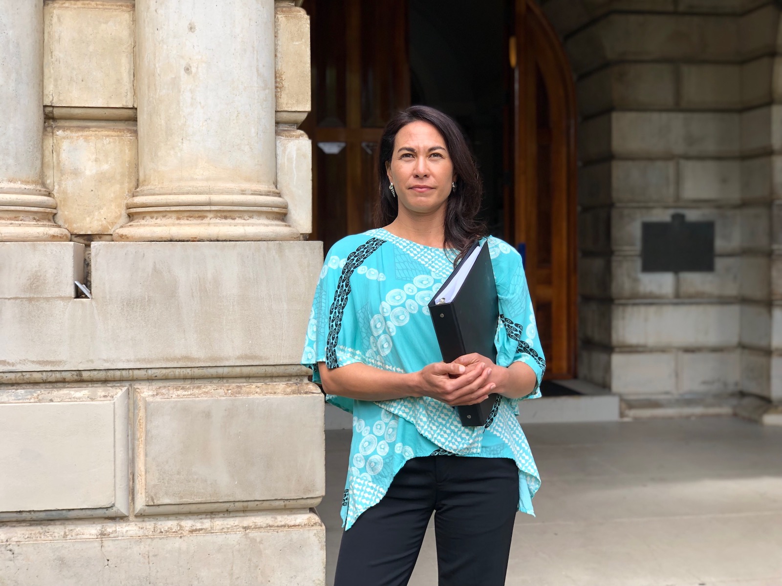
Leināʻala Ley, an attorney for Earthjustice, stands in front of the Supreme Court of Hawaii the morning the lawsuit was filed.
Marti Townsend / Courtesy of Earthjustice
“We have the tools in our hands to fix the climate crisis, we just have to have the political will to do that,” she added. “This lawsuit can help push the government in the right direction.”
Today’s youth have the most to lose if we don’t act quickly to address climate change. The personal stories of the youth plaintiffs, who are between 9 and 18 years old and come from across the Hawaiian Islands, illustrate how climate change is already affecting the region. Fourteen-year-old Navahine and her family maintain a fishpond, but polluted runoff from unusually heavy downpours and rising sea levels threaten the Native Hawaiian practice. “If urgent reductions in greenhouse gas emissions are not made, these lands will most likely be underwater within my lifetime. And if that happens, our legacy and our future on this island will be lost,” she told Grist.
Ka‘ōnohi, 15, is a diver and spearfisher, but ocean acidification and rising temperatures have caused wide-scale bleaching and die-offs of Hawaii’s once-vibrant reefs. Others have had their homes threatened by intensifying storms, their roads washed away by flash floods, and their food and water security torn away by the changing climate.
In previous cases, youth have sued the federal government and other state governments over climate inaction. In 2015, 21 young people filed a lawsuit against the federal government in a case called Juliana v. United States, or Youth v. Gov. Five years later, a federal appeals court dismissed the lawsuit, writing that the issue should be addressed by the executive and legislative branches, rather than the courts, but now the plaintiffs have filed an amended complaint.
Recently, activists have been trying a different tactic, filing lawsuits in places like Hawaii, where the state constitution guarantees the right to a clean and healthful environment. Similar cases are also pending in Utah and Montana, but the outcomes are still uncertain.
As kids, it can be frustrating “to constantly feel like our voice isn’t heard in these big conversations about our future,” said Navahine, the lead plaintiff. “These decisions that are made regarding climate change are going to impact my generation and the generations after us the most.” She sees this lawsuit as a way for her and her peers to make their voices heard.
Though it feels a bit overwhelming, she said, “I do know that it’s the right thing to do. And I really hope that it makes an impact.”
Located in the United Republic of Tanzania, the Ngorongoro Conservation Area is a UNESCO World Heritage Site famous for its beautiful landscape and “Big 5” game — elephants, lions, leopards, buffalo, and rhinoceros. Every year, the area’s attractions draw hundreds of thousands of visitors from around the world. The park is also home to roughly 80,000 Indigenous Maasai people who have called the region home for millenia, living on the rich and fertile landscape. But since its creation in 1959, the Ngorongoro Conservation Area (NCA), the Maasai population in the park has steadily increased. Now, the government is trying to evict the Maasai, a move officials say is necessary to protect the park’s environment, but that the Maasai say is an attempt to sacrifice their way of life for tourism and profit.
According to a new report from the Oakland Institute, a California-based think tank, Tanzania’s proposed resettlement sites have “serious issues” for the Maasai and are critically flawed. “While denying plans for mass evictions in the NCA, the government’s strategy to deprive residents of basic services and the ability to graze livestock, leaves the Maasai with few options for survival in the land they have stewarded for generations,” said Anuradha Mittal, Oakland Institute’s Executive Director.
Around the world, Indigenous people are being evicted and even murdered by governments and international NGOs in the name of conservation, despite strong evidence that Indigenous land stewardship is actively helping biodiversity. Both the Maasai and international advocacy groups have strongly resisted what they are calling an illegal eviction. The Maasai and international groups have called on the Tanzanian government to respect their rights before making any decisions regarding the land and Maasai stewardship of it. In April, eight U.N. Special Rapporteurs also raised concern about the evictions, and this month, the United Nations Permanent Forum on Indigenous Issues called on Tanzania to immediately stop the eviction plans.
According to the report, the Tanzanian government has failed to live up to the promises it made in its resettlement plan. Based on field research at three proposed resettlement locations, the report identifies several areas where the actual sites lack adequate water, sufficient grazing land, and other infrastructure promised by the government. The sites are also not equipped to provide healthcare, education, and other social services that were supposed to be a part of the plan.
Local, non-Maasai residents also say they were never consulted about receiving the resettled Maasai population and the report identifies an increased risk of conflict because of the plan, pointing to one resettlement that has already seen conflict over limited water and grazing resources. The report alleges that the influx of Maasai from NCA would only add to the chance of conflict.
The Oakland Institute is calling on the Tanzanian government to stop the eviction plans and to give the Maasai more decision making power. It also calls on UNESCO to use its leverage to help the Maasai. Tanzania’s Ministry of Natural Resources and Tourism and UNESCO did not immediately respond to a request for comment.
“It is imperative that Indigenous residents of the NCA are not just consulted but given real authority over any resettlement schemes or changes to land use regulations,” Anuradha Mittal said.
Northeastern Minnesota’s Iron Range has been a major mining hub since the 1860s. Nestled among thick forests and many of the state’s famed “10,000 lakes,” open-pit mines there produce low-grade iron ore that’s shipped to steel mills around the country. But for the last few decades, as the U.S. steel industry has waned and demand for different minerals has grown, multiple companies have proposed something new: hard rock mining, which involves extracting valuable metals from sulfide ores and produces large amounts of acidic waste. One of these, the PolyMet Mining Corporation, has been locked in a battle to open Minnesota’s first copper-sulfide mine near the tiny town of Babbitt for over 17 years. The $1 billion project has been mired in legal challenges almost since its inception.
Now, environmentalists and nearby tribal nations hope that recent court victories will shut it down for good. Earlier this month, the Army Corps of Engineers held a hearing to decide whether to reissue a permit for PolyMet to dump waste rock on more than 900 acres of wetlands, a possibility that the downstream Fond du Lac Band of Lake Superior Chippewa vehemently opposes. The Environmental Protection Agency came out in support of the tribe, telling the Corps that allowing the mine to go ahead with its plans would risk contaminating the already-polluted St. Louis River with dangerous levels of mercury.
As opponents highlight the mine’s environmental impact, PolyMet is touting its potential for producing valuable metals needed to build transmission lines and electric vehicle batteries — making it the latest dispute over how to responsibly mine the materials needed for the renewable energy transition. In Nevada, a lithium mine is facing stark opposition from tribes who say it would damage a culturally, historically, and spiritually significant area. Cobalt miners in the Democratic Republic of Congo have reportedly been subjected to exploitative working conditions, including by the company that owns PolyMet. At the same time, a bipartisan group of lawmakers is pushing for an increase in domestic mining in response to supply chain issues and increased demand.
Activists say these conflicts are increasingly testing the idea of a “just transition” — one that doesn’t repeat the mistakes of the past, such as prioritizing extraction over the needs of Indigenous people and the environment, in shifting to new forms of energy.
“The Band is not opposed to mining,” Band Chairman Kevin Dupuis Sr. said in a press release on the first day of the Army Corps hearing. “But if mining is to occur, we must ensure that our waters are protected, not just for the Band, but for all Minnesotans.”
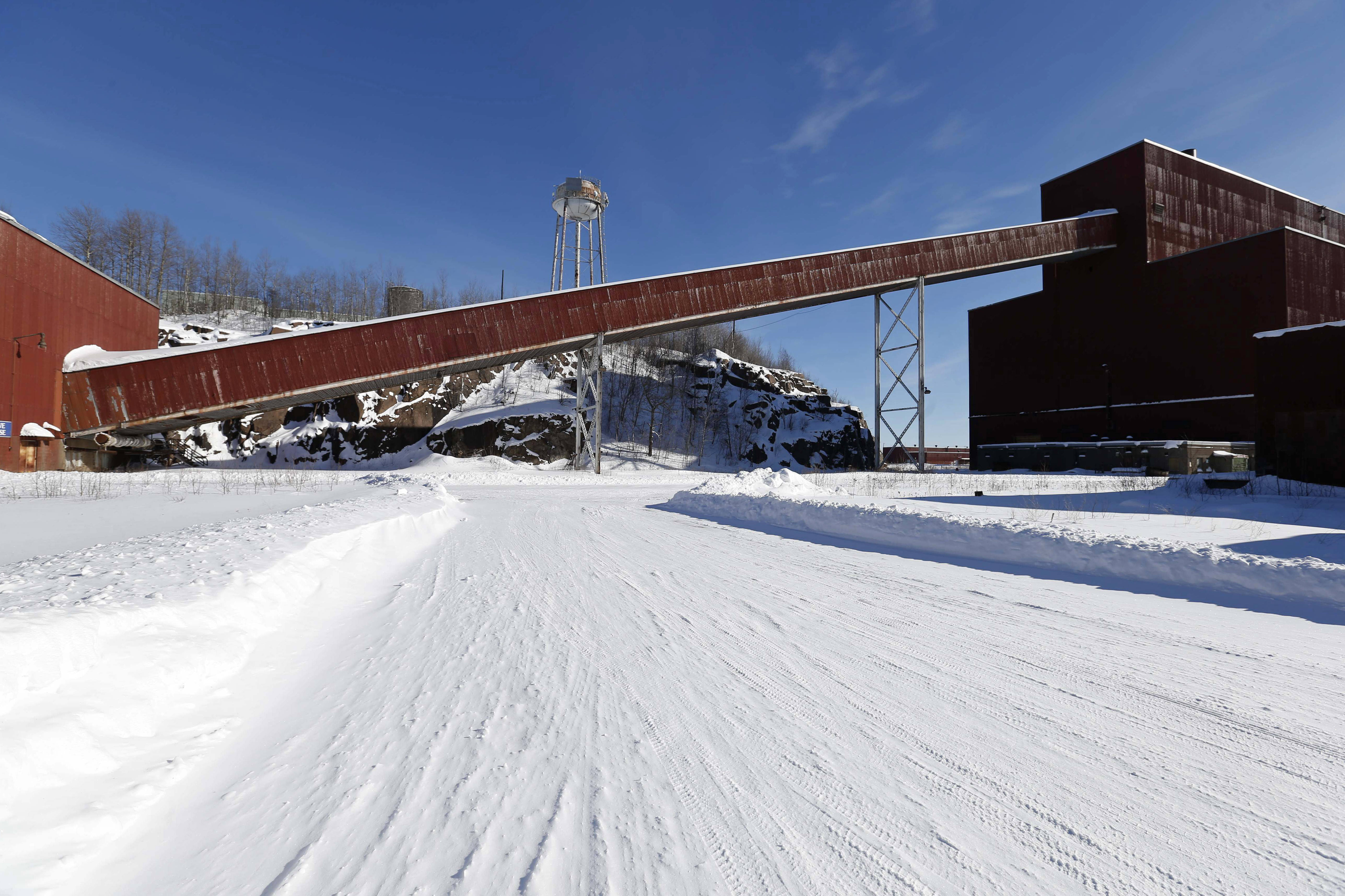
This former iron ore processing plant near Hoyt Lakes, Minn. would become part of a proposed PolyMet copper-nickel mine. Jim Mone/Associated Press
PolyMet, which is majority owned by the Swiss mining conglomerate Glencore, first unveiled plans for its Northern Minnesota mine, the NorthMet project, in 2005. Since then, it’s faced legal challenges to multiple other permits it needs to move forward, including water pollution, air pollution, and mining permits that are either tied up in litigation or have been sent back to state agencies for further study and adjustment. And it’s not the only disputed mine in Minnesota; in January, the Biden administration canceled two federal leases for the Twin Metals mine, which would have extracted copper, nickel, and precious metals near the Boundary Waters Canoe Wilderness.
In the last few years, PolyMet has leaned into its role as a supplier of elements needed to build electric car batteries and other renewable energy infrastructure. The company has said that the area of the NorthMet project contains significant reserves of copper, nickel, and palladium — “metals vital to global carbon reduction efforts” — and that it would become one of the country’s top suppliers once the mine becomes operational, although it can’t guarantee how much of its eventual output would go toward green energy.
“These metals that we’re producing are really crucial to not only modern society,” PolyMet spokesperson Bruce Richardson told MinnPost, but also “for clean energy and climate change and our own security.”
JT Haines, the northeastern Minnesota program director for the Minnesota Center for Environmental Advocacy, called this view “problematic.” The industry is using the demand for new metals for green energy as a “safe harbor talking point,” he said, to justify destructive mining activities without addressing the core issue of consumption and extraction. Instead, Haines argued, the focus should be on how to recycle and reuse the metals that already exist while reducing consumption and energy use in the first place.
“It’s clear that we can’t mine or drive our way out of the climate crisis,” Haines said.
The contested permit at the center of the recent Army Corps hearing was issued in 2019 – despite years of opposition from the Fond du Lac Band, which as a sovereign nation has the right to set its own water quality standards and the legal status of a downstream state. Last year, following a lawsuit from the tribe, the EPA determined that the NorthMet project “may affect” water in the Fond du Lac Band’s territory as well as the state of Wisconsin, and asked the Army Corps to suspend the permit.
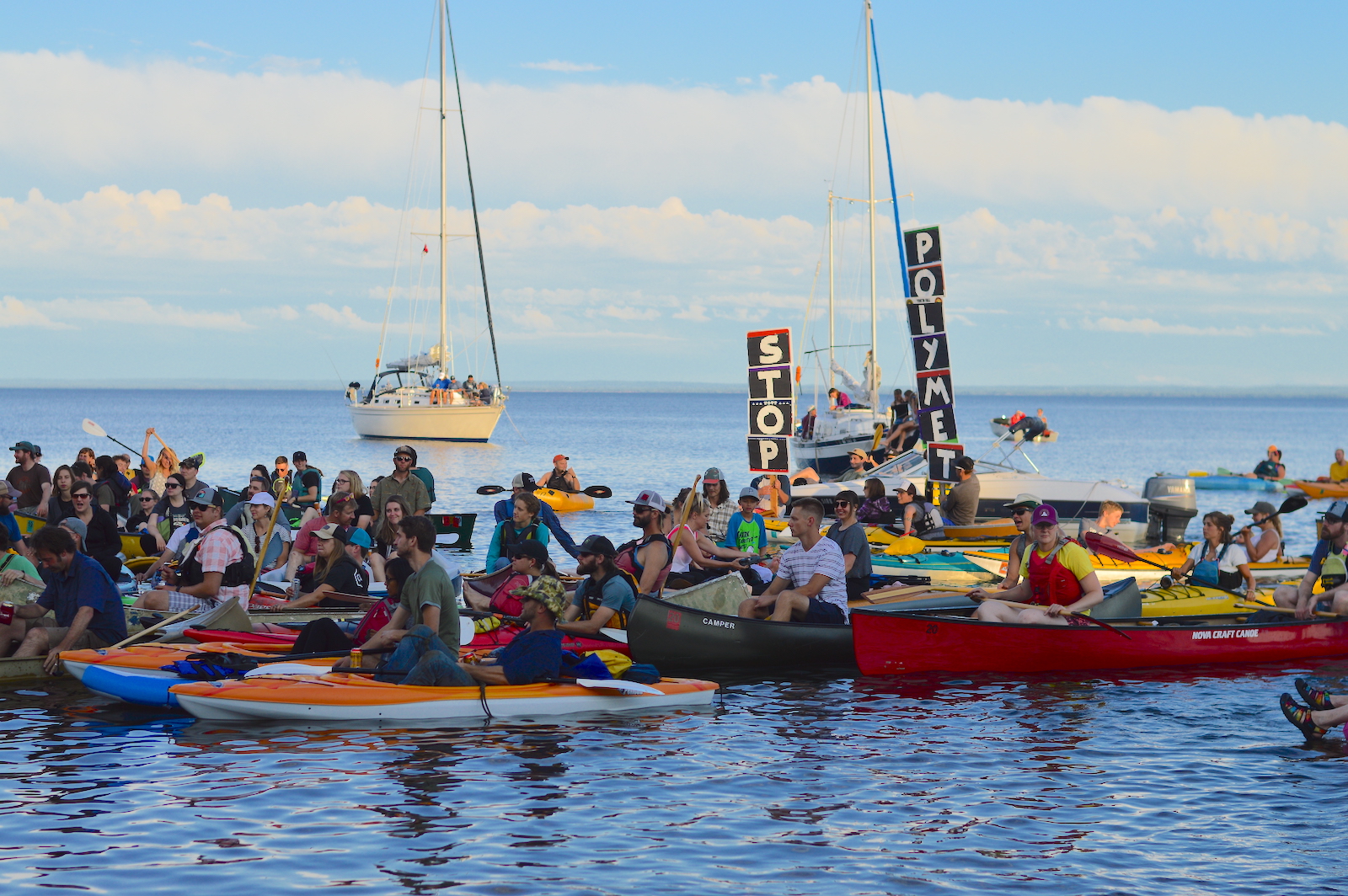
Protesters gather on Lake Superior to express opposition to PolyMet’s plans to open Minnesota’s first copper-sulfide mine. Duluth for Clean Water
At the hearing on May 3, the EPA said PolyMet’s plan to dredge and fill the wetlands with mining waste could contaminate multiple waterways that drain into the St. Louis River, which flows through the tribe’s reservation near Duluth. The biggest concern is mercury, a potent neurotoxin that can be a byproduct of mining. The NorthMet project would also release sulfate, which helps convert mercury into methylmercury — the metal’s most toxic form, which accumulates in fish and other wildlife and can eventually be toxic to humans that consume it.
The St. Louis River is already one of Minnesota’s most mercury polluted waterways, and the Fond du Lac Band relies on both the river and its upstream tributaries for hunting, fishing, and gathering foods such as wild rice. While PolyMet said it would capture and treat the mine runoff to prevent mercury and sulfate pollution, the Fond du Lac Band’s scientists testified that the discharge would exceed the tribe’s water quality standards, which are more stringent than Minnesota’s.
The Army Corps is now accepting public comments through June 6, after which it will decide whether to reinstate, permanently revoke, or modify PolyMet’s permit. PolyMet did not respond to a request for comment from Grist.
Although this is the first time that a tribal nation has used its authority as a “downstream state” to challenge a federal permit that could impair its lands and water, a win in the PolyMet case could set a precedent for other tribes to do the same, said the Fond du Lac Band’s attorney, Vanessa Ray-Hodge.
“It’s an important mechanism for tribes to be able to use and to have available to them to protect their reservation waters from development, just like other states can do all the time,” Ray-Hodge said.
European supermarket chains like Aldi and Sainsbury’s, European pet food producers, and Kentucky Fried Chicken restaurants in the U.K, profit from human rights abuses and Indigenous land theft in Brazil. That’s according to a new report that details human rights abuses in a chicken supply chain from Brazil to Europe. The report comes amid violence against Indigenous communities in Brazil, and specifically in the state of Mato Grosso do Sul, where rampant deforestation and violent attacks against the Guarani Kaiowá continue to escalate.
The report, released by Earthsight, a UK-based non-profit, and De Olho nos Ruralistas, a Brazilian agribusiness watch group, traces major international companies’ chicken production back to Brasilia do Sul, a 23,000-acre soy farm in the state of Mato Grosso do Sul, built on Guarani Kaiowá land. Evicted from their territory in the 1950’s, the land was deforested over the years while the Guarani Kaiowá fought unsuccessfully in Brazil’s courts to regain title to their land. In 2003, a Guarani Kaiowá leader, Marcos Veron, was beaten to death by Brasilia do Sul workers and hired gunmen after leading an effort to reclaim a portion of the territory.
“When we’re not struck by gunmen we’re struck by the courts.” said Valdelice Veron, a Guarani Kaiowá leader and Marcos’ daughter. “The aim of Brazil’s rulers is the extermination of our people. My message to you watching our situation in Mato Grosso do Sul and in Brazil is that you rise up with us.”
According to the report, the supply chain works like this: Lar Cooperativa Agroindustrial, Brazil’s fourth largest chicken slaughtering company, is a significant buyer of Brasília do Sul soy, which it uses to feed chickens that it sells internationally. Westbridge Foods, a British poultry supplier, buys thousands of tons of chicken from Lar Cooperativa to supply supermarkets like Sainsburys and Aldi, as well as restaurants like Kentucky Fried Chicken. Also buying from Lar Cooperativa is German firm Paulsen Food, which owns pet food companies and uses the chicken in dog and cat food.
“Businesses in Britain have failed to cut ties with Brazilian producers linked to the violence, making us consumers unwitting participants in tragic stories like that of the Guarani Kaiowá,” said Rubens Carvalho, Earthsight’s head of deforestation research.
Westbridge and Kentucky Fried Chicken did not immediately respond to a request for comment. Other companies, including Sainsbury’s, denied receiving any chicken from Lar Cooperativa and did not immediately respond to requests for comment on the report.
The report called on the European Union and the United Kingdom to make reforms to chicken and soy supply chain regulations, and Earthsight’s Ruben Carvalho said that the findings demonstrate the need for stronger legislation that includes “the protection of indigenous land rights, and to cover key commodities, including soy and soy-fed chicken.”
The Guarani Kaiowá’s fight is part of a larger, global effort to protect land and the environment as research shows that Indigenous land stewardship is crucial to preserving biodiversity and combating climate change. “Our aim is to restore the health of the land to allow us to reconnect with this divinity and give meaning to our lives,” Eliel Benites, a Guarani Kaiowá leader and academic, said in the report.
Across Brazil, Indigenous people are being killed by illegal mining and advancing agribusiness activities. Since 2003, over 500 Indigenous people have been killed in the state of Mato Grosso do Sul—more than any other region and a third of all Indigenous killings in Brazil during that time and primarily due to expanding agribusiness. “Many massacres have happened for us to be here today,” said Valdelice Veron, the Guarani Kaiowá leader, in the report. “We’re here because this is our sacred land, it’s where we have our history and our memory. It’s our Tekohá [sacred village] and we don’t forget it.”
This story is published as part of the Global Indigenous Affairs Desk, an Indigenous-led collaboration between Grist, Indian Country Today, High Country News. Native News Online also contributed to this article.
The United Nations Permanent Forum on Indigenous Issues, or UNPFII, concluded its 21st session on Friday, calling on governments, courts, and U.N. agencies to implement mechanisms to support and protect Indigenous peoples’ lands and lives. It also recommended that Indigenous peoples be given more opportunities to participate in the U.N.’s General Assembly process through “enhanced participation” – a move that could elevate the forum to a level on-par with member states.
The forum is one of the few official venues where Indigenous voices are reliably heard at the U.N., but its role is constricted by a structure that only allows UNPFII members to make recommendations to other U.N. bodies, like the the Economic and Social Council or UNESCO. Indigenous nations, communities, and peoples are classed as non-governmental organizations, and cannot vote or speak to U.N. bodies without an invitation, including the General Assembly.
“A basic, first step for enhanced participation would be the United Nations recognizing that tribes have a right to be here and have a right to be able to attend,” said Geoffrey Roth, a Standing Rock Sioux descendent and UNPFII member. With enhanced participation, Roth says, Indigenous peoples could engage directly, and equally, with member states to ensure rights are protected and concerns are heard.
“We need the support of the absolute leadership of the United Nations to address Indigenous human rights,” said Hannah McGlade, a Noongar woman and member of UNPFII from Australia. “We mustn’t lose sight of the changes that can come through our engagement, our advocacy, and our work with member states.”
In a draft report put forth by UNPFII leaders Friday, members urged countries to implement the United Nations Declaration on the Rights of Indigenous Peoples, including calling on the United States and Canada to develop national action plans to implement the agreement. Both countries have signed onto support UNDRIP after years of opposition, but have not generally moved to codify those international rights into their legal systems.
Under the forum’s proposals, relevant UN agencies, like the World Bank, the Food and Agriculture Organization, and UNESCO would initiate studies on the implementation of FPIC, the impacts of industrial fishing on Indigenous communities, and develop and align internal policies to protect human rights with regards to intellectual property rights and traditional knowledge. In the wake of the COVID-19 pandemic, the forum also recommended that the World Health Organization incorporate Indigenous cultures into the social determinants of health policy.
“This is really a very challenging moment for the Permanent Forum, that continues to be a subsidiary body,” said Darío José Mejía Montalvo, the chair of the forum, in an interview. “We still don’t have enough of a voice in those bodies where the decisions are made at the United Nations and the states.”
Despite the challenges and limitations of UNPFII, Mejía Montalvo believes that it can help elevate the concerns of Indigenous peoples around the world and empower them to push for change in their countries. A sentiment echoed by Geoffrey Roth who hopes to put pressure on international bodies like the World Bank to start making change. Roth says that pressure could be stipulating that the World Bank has a process in place to ensure member states that receive funding have a strong FPIC policy. If they don’t, he says, the World Bank could refuse to work there. “The money is where the power is – and the World Bank is the pocket book,” he said.
Leaders say next year’s session will focus on global health and climate change.
This story is published as part of the Global Indigenous Affairs Desk, an Indigenous-led collaboration between Grist, Indian Country Today, and High Country News.
When Cielo Magdalena Gómez López, Maya Tseltal, first arrived in the U.S. from Mexico in 2005, she was surprised at how many other Mayan people she met in her new home of Tampa, Florida. Trained to teach English as a second language, Gómez López quickly became the de facto interpreter, translator, and advocate for the Indigenous Mexican community in Tampa, many of who spoke Tsotsil and Tseltal but no English or Spanish. “It was like taking care of my little brothers and sisters,” she said. “We were all going through the same struggles.”
Now, Gómez López works at the Mexican Consulate in Orlando, where she provides translation and interpretation services in an official capacity, but she says much more support for Indigenous migrants is needed.
From the moment Indigenous migrants and refugees arrive in the U.S. they face obstacles. Border crossings rarely have Indigenous language interpretation available, leaving migrants vulnerable and often unaware of the options and services available to them. Once they make it to a new home, language challenges continue.
In an intervention delivered at the United Nations Permanent Forum on Indigenous Issues, Rosalba Sotz, Maya Tseltal and a representative from Red de Indígenas Migrantes, called on the Mexican government to employ more Indigenous leaders at their consulates in the U.S. to help with translation, interpretation, legal advocacy, and other services. Many Indigenous people in Mexico and Central America are farmers and are particularly sensitive to climate disasters, changes in weather patterns, and drought. And as those populations continue to bear the brunt of climate change and seek refuge outside of their homelands, Sotz says the U.N. must pay greater attention to the unique challenges facing Indigenous migrants.
“Climate change is pushing people to leave their territory,” she said. “We are going to see more migration and more displacement.”
Geoffrey Roth, a Standing Rock Sioux descendant and member of the United Nations Permanent Forum on Indigenous Issues, says that the forum can make recommendations to member states to adopt recommendations like Sotz’s. He added that Indigenous migrant populations are uniquely vulnerable. “We need to address these issues on climate change and the environment the best we can so we can allow people to stay in their homeland if possible,” he said. “If not, we need to be able to provide services and support to Indigenous peoples wherever they are.”
For Indigenous people, displacement from their land and people can be particularly difficult. “Our way of life is related to the community and being isolated is a very traumatic experience,” Sotz said.
Thousands of Indigenous people from Mexico, Central America, Africa, and other parts of the world call the U.S. home, but the exact number isn’t known because they are often counted among other immigrants, rather than as Indigenous people. That means that the unique challenges facing Indigenous immigrants are often overlooked. “Language is a huge issue,” said Roth. “It’s been an issue on the borders, but it’s also an issue beyond the borders.”
Gómez López says that empowering and employing Indigenous people will help their communities access and understand services, become more comfortable in their new homes, and contribute to the community both in the U.S. and Mexico. She also hopes that her work can serve as an example for other consulates serving Indigenous populations.
After living undocumented in the U.S. for fifteen years, Gómez López secured a diplomatic visa through her work at the Consulate. Next year, however, the visa is set to expire, meaning she may have to return to Mexico, where she hasn’t lived in nearly 20 years. Sotz says that Gómez López’s situation illustrates the need for institutionalized Indigenous consulate employees. If Gómez López leaves, not only will her life be uprooted, but the Indigenous community in Florida will lose her years of knowledge and expertise.
“In our own country we have been discriminated against and excluded,” Sotz said. “That situation is exponentially worse when you migrate.”
This story is published as part of the Global Indigenous Affairs Desk, an Indigenous-led collaboration between Grist, Indian Country Today, and High Country News.
In the 1970’s, the Kenyan government evicted hundreds of Indigenous Endorois families from their homelands to create the Lake Bogoria National Reserve. The park is known for its hot springs, beautiful Rift Valley landscape, and large flamingo population. The Endorois were devastated. Disconnected from their homelands and traditions, the Endorois faced poverty, language loss, separation from cultural landmarks, and other threats. “It took away our sense of belonging,” said Carson Kiburo, Endorois and Executive Director of the Jamii Asilia Centre. “We have lost our culture.”
The Endorois challenged the eviction in court, eventually taking their case to the African Commission on Human and Peoples Rights. In 2010, the Commission ruled that Kenya had violated the Endorois’ human rights and provided seven recommendations for restitution and compensation, including the return of land, providing access for animal grazing and ceremony, and financial damages. The Commission established a three month timeline for the Kenyan government to provide a progress report, but 12 years later, the Endorois say that Kenya has failed to follow through on the Commission’s core recommendations.
This week, Kiburo is demanding Kenya adopt the Commission’s other recommendations and using the United Nations’ Permanent Forum on Indigenous Issues to call for stronger international action to support the Endorois in defending their rights.
“We want to retain our sense of belonging, our culture, our food sovereignty, our spirituality, and contribute to humankind,” Kiburo said. “That’s all we’re asking.”
Neither Kenya’s Wildlife Service or National Commission on Human Rights immediately responded to a request for comment.
“What happened to my people is about to be repeated.” he said “It doesn’t make sense.”
Jennifer Corpuz, Kankanaey Igorot from Northern Philippines and Senior Global Policy & Advocacy Lead for Nia Tero, said that harmful conservation practices are a widespread issue. Pointing to examples from Thailand, the Democratic Republic in the Congo, and other countries, Corpus says that evicting Indigenous people in the name of conservation is not only a violation of human rights, but also a threat to biodiversity. “This cannot be allowed to continue because when you displace the traditional authorities, it becomes difficult to protect it,” she said, adding that Indigenous land represents “islands of biodiversity in a sea of degradation.”
Joan Carling, Global Executive Director of Indigenous Peoples Rights International, says that both national reforms and international enforcement mechanisms are needed to ensure Indigenous peoples’ right to live on and defend their land is upheld. “We must make sure that there are laws that recognize our land rights and the way we manage our resources,” she said. “They cannot penalize us when we do our traditional occupations or livelihoods in our area.”
Kiburo, who is also a student at Kabarak Law School in Kenya, says that the Endorois have to pay to access the land where their ancestors are buried and are not permitted to perform their ceremonies or prayers on the land. Restoring that access is one of the Endorois’ primary demands, however, Kiburo says the Kenyan government is the main obstacle. “Those economic and social rights are very much enshrined in the constitution of Kenya,” he said. “[The government is] just not committed.”
Editor’s note: Nia Tero is a funding partner with Grist. Funding partners have no role in Grist’s editorial decisions.
Bounded by the Bitterroot Mountains to the west and the Sapphire Mountains to the east, Montana’s Bitterroot Valley is home to renowned fly fishing streams and soaring vistas. Its forests, however, are facing the greatest wildfire risk in the entire state, with towns like Florence, Victor, and Darby all in the nation’s 98th-plus percentile for risk. Yet houses continue to be built at a rapid clip, many of them in hazardous areas.
Theoretically, the Infrastructure Investment and Jobs Act, a $1.2 trillion bill that funds improvements in transportation, water, energy, broadband, and climate resilience projects, should be able to help. The legislation, signed into law by President Joe Biden in November 2021, includes money to make forests more resilient to fire and defend at-risk communities. But according to a recent analysis by the Montana-based research group Headwaters Economics, over half of the communities in the West might not be able to access those funds.
Researchers examined 10 factors that influenced how well-equipped communities were to apply for grant funding, and then used those factors to calculate each county and community’s “rural capacity” score. For instance, Missoula County, Montana, home to the state’s second-largest city and flagship university campus, scored 94 out of 100, while Carter County, Montana, where there is no county head of planning and just 20 percent of adult residents have attended college, scored just 45, the lowest in the state.
Within the West, Montana stands out: More than three-quarters of its communities have index scores below the national median. The state’s low capacity exemplifies the challenges rural communities across the West face, including a reliance on boom-and-bust industries that create financial instability, and a lack of grant writers, land-use planners, and emergency planners that would be helpful in applying for federal funds. “You go to a rural community, and typically the mayor is almost always part-time,” said Don Albrecht, director of the Western Rural Development Center at Utah State University. “They don’t have the resources or the experience or the expertise to even write grants to get the money in the first place.”
More than half the communities in Wyoming, New Mexico, and Idaho rank below the national median on Headwaters’ rural capacity index scoring system. Clark County, Idaho; Esmeralda County, Nevada; and Jackson County, Colorado, like Carter County in Montana, also received capacity scores in the 40s. At the same time, Headwaters also found that many of the rural communities rated as having low capacity also face the highest climate threats.
When overlaid with data about flood and wildfire risk, Headwaters’ analysis reveals areas with stark capacity barriers, often exacerbated by historical injustices, as well as high vulnerability to the impacts of climate change. In Montana and elsewhere, many of these communities are on or near Native American reservations. In the town of Hays on the Fort Belknap Indian Reservation, for example, capacity is among the lowest 5 percent in the country, while both wildfire and flood risk are higher than in 90 percent of the country.
In theory, the $47 billion the infrastructure bill designates for climate resilience can help communities prepare for floods, fires, storms, and droughts. But Headwaters’ analysis suggests that areas with low capacity might not submit requests in the first place. “The point of this was to shed light on major barriers that exist for communities trying to plan and finance climate adaptation projects,” said Patty Hernandez, the executive director of Headwaters Economics. “For our team, it was really striking how widespread the problem is.”
Over the next few weeks, the Biden team is taking a cross-country tour to discuss the legislation ahead of the midterm elections in November, with a particular focus on rural areas. According to Mitch Landrieu, Biden’s infrastructure czar, officials will stop in a handful of Western states, including Colorado, Alaska, Arizona, Washington, and Nevada. Behind the scenes, federal agencies in charge of divvying up infrastructure funding are defining grant guidelines and making spending plans. “These decisions are being made right now that will impact the ability of rural communities to access the dollars that are coming online,” Hernandez said.
Officials say that access for rural communities is their top priority, pointing to their “rural playbook,” which details money set aside for urgent rural issues like broadband internet access and upgrading electricity and wastewater systems. Last Wednesday, the Biden administration launched a pilot program called the Rural Partners Network, designed to address capacity issues by putting staff on the ground in rural communities to “provide local leaders with the expertise to navigate federal programs,” according to a fact sheet from the USDA.
It’s essential for state and federal officials to work directly with communities in order to make sure that the money gets where it’s most needed, Albrecht said. Otherwise, those with more resources will “lap” it all up. According to The Washington Post, municipalities from Florida to California are already hiring lobbyists to influence where infrastructure money goes.
There are also policies the Biden administration could enact to give communities a fair shot at funds, Headwaters’ analysis suggests. The administration could eliminate requirements for communities to match contributions from federal grants, which can be difficult in sparsely populated areas with a limited tax base. Granting agencies could even directly identify places with high need and award them money without requiring applications. Hernandez said that new approaches are necessary to give rural towns across Montana, and the West, a chance. “I can’t imagine a scenario,” she said, “where a one-size-fits-all rubric for scoring proposals is ever going to work out for rural communities.”
This story is published as part of the Global Indigenous Affairs Desk, an Indigenous-led collaboration between Grist, Indian Country Today, and High Country News.
In 2017, Hurricane Maria hit the Caribbean, destroying homes, killing thousands, and driving many from the region. Indigenous Taíno people in Puerto Rico were on the front lines of the disaster, which has since been compounded by environmental violence in the form of toxic military waste, luxury development on cultural sites, and other threats. But the Taíno struggle to get those concerns acknowledged by the U.S. and other governments. Now representatives are at the United Nations Permanent Forum on Indigenous Issues (UNPFII) in New York to call attention to their situation.
“If we’re not getting visibility or any kind of recognition at the national level, we have no choice but to take it outside and try to build that visibility for our people,” said R. Múkaro Agüeibaná Borrero, President of the United Confederation of Taíno People.
The Taíno people are Indigenous to the Caribbean and live in Puerto Rico, Cuba, the Dominican Republic, the U.S. Virgin Islands, and more. When Christopher Columbus made landfall in 1492, the Taíno were the first people he met. Today, Puerto Rico is an unincorporated territory of the United States, which means that it is neither an independent country nor an official state. Puerto Rico has a non-voting member of Congress and does not have electoral college votes in presidential elections. Because of this colonial relationship, the Taíno have few platforms to make their concerns heard.
International forums like the UNPFII are a rare opportunity to directly engage with officials from the United States and other countries — providing space for the Taíno to advocate for policies that will help their communities. “There is a narrative that Taíno people were wiped out,” Borrero said. “So we have to make statements at the international level, to say ‘wait a minute, we are here.’”
Andrea Carmen, Yaqui Nation and Executive Director of the International Indian Treaty Council, says that for the Taíno, Puerto Rico’s political status presents challenges for the Taíno. “What makes them unique is they are still residents of a colony,” she said. Carmen added that, like the Taíno, most Indigenous peoples around the world also lack state recognition, which makes the UNPFII and other international venues even more important in their fight for rights.
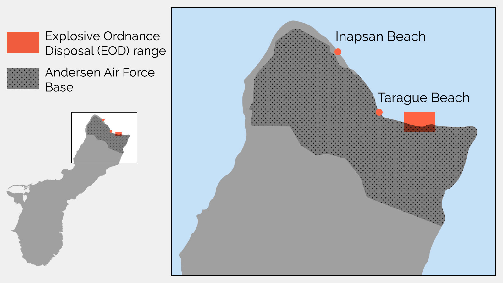
In a statement to the forum, Tai Pelli, another representative from the United Confederation of Taíno People, highlighted the environmental and climate crises facing Indigenous peoples in Puerto Rico. Increasingly powerful storms have destroyed homes and driven many from the island while illegal toxic waste dumping and military waste contamination are also serious issues. On the island municipalities of Vieques and Culebra, the U.S. military conducted weapons testing for over 60 years, leaving unexploded ordinance and dangerous chemicals behind. “Increasing cancer rates and other non-contagious diseases are a direct result of the environmental injustices our people confront every day,” Pelli said.
Pointing to luxury hotels and other development projects on culturally significant sites like the Dry Forest and the Kaguana Ceremonial Center, Pelli called on the UN to confront the issue with UNESCO, which oversees some of the sites, and demanded a review of UNESCO’s protected areas mandate and greater transparency. “The wrath of greed and uncontrolled development are beginning to seem as dangerous as the hurricanes, earthquakes and pandemic that we are still trying to survive,” she said.
The United Confederation of Taíno People also called attention to Taíno language revitalization efforts, which will lead to the publication of the first Classic Taíno Dictionary and Grammar Guide later this year. Borrero noted, however, that the International Decade of Indigenous Languages must not overlook Indigenous Caribbean languages and called on the Permanent Forum to give special attention to insular Caribbean Indigenous Peoples, including those in both self-governing and non self-governing territories.
“We’re not only raising the visibility of who we are within the U.S.,” he said. “We’re also raising the visibility of our people for other Indigenous peoples so that we could build that solidarity regionally and internationally.”
This story is published as part of the Global Indigenous Affairs Desk, an Indigenous-led collaboration between Grist, Indian Country Today, and High Country News.
At the world’s largest gathering of Indigenous leaders, women are talking about how to hold financial institutions accountable for fueling climate catastrophe through investments in the extractive industry.
Michelle Cook, Navajo, was among those who offered testimonies focused on the women at the frontlines of extractive projects, the boardrooms of financial institutions, and the halls of governments. Speaking at a side event hosted by Women’s Earth and Climate Action Network at the 21st session of the U.N. Permanent Forum on Indigenous Issues in New York, Cook described the work as being part of a sacred obligation.
“That’s what we’re doing, fulfilling a prayer for the world – for nature – with love, compassion, and with courage. No other weapon than that, the truth,” Cook, the founder of Divest Invest Protect, said. “For some, that is so terrifying. Indigenous women will not give up … We will not be intimidated, shamed or be afraid just for being who we are.”
The international forum side events offer participants the opportunity to continue thematic dialogues outside of the forum’s schedule, which is more limited than previous years due to the pandemic and is operating on a hybrid format this year. Summer Blaze Aubrey, Cherokee and Blackfeet, is a staff attorney for the International Indian Treaty Council and also spoke on the panel. She noted that racism and genocide are at the center of human rights violations around the world. Atrocities are ongoing and fueled by the extractive industry, she added, even with “green energy” initiatives moving forward. She pointed to the White House’s Russian rhetoric and the Defense Production Act, which was enacted to jump start new mines or expand existing ones.
“Engaging in the extractive industry isn’t moving forward, it’s not going to help in the long run. It’s part of capitalism,” Aubrey said. “It is not helpful…We see throughout the extractive industry on Turtle Island it’s linked to violence against women. It’s so nuanced and interconnected that you cannot speak on one without speaking on the other.”
Women on the panel maintained that due diligence must occur continuously through development projects, not just during the initial phases. But ultimately, they say, society needs to divest from the extractive industry altogether.
“Indigenous people are providing the answers,” Aubrey said, referencing traditional knowledge and science. “We understand how to live symbiotically with the environment, How to feed people. We already have systems in place that will protect us and the world.”
She added that corporations and financiers need to recognize that and be engaged in those principles and strategies.The panel called out BlackRock, the world’s largest asset manager, saying the investment company has an insatiable appetite for feeding its bottom line. BlackRock presently does not have an Indigenous rights policy, a shortcoming that Women’s Earth and Climate Action Network founder Osprey Orielle Lake said should change immediately.
Like countless others during the first week of the Permanent Forum, the panel consistently returned to the matter of free, prior and informed consent (FPIC). FPIC specifies that developers must engage with impacted Indigenous communities to ensure their participation and consultation. However, despite the international human rights principle being widely adopted by U.N. member states via the Declaration on the Rights of Indigenous Peoples, many experts and leaders have identified that the articles are not being recognized or applied effectively, leaving the land and people vulnerable to exploitation. Among the other solutions highlighted, included investing in climate justice frameworks that center traditional ecological knowledge.
For women like Maria Violet Medina Quiscue, from Pueblo Nasa in Colombia, it takes courage to speak out on these issues – especially on a global scale – because land and human rights defenders are being murdered, meaning that publicly criticizing the institutions, corporations and nations behind them places her life on the line. Quiscue described the deeply entrenched racism against Indigenous people in Colombia, which has been on full display as of late.
For the last seven months, roughly 2,000 Indigenous people have been living at an encampment at Bogota National Park after being displaced by extractive industries and paramilitary groups. Anti-Indigenous rhetoric from Colombian politicians has created a hostile environment for Indigenous people, with grocers and store owners refusing to serve Indigenous people. Quiscue says racism in Bogota ramped up after Mayor Claudia Lopez Hernandez unleashed a slew of attacks against Indigenous people at the encampment.
Quiscue says the discrimination they are currently facing is rooted in colonization. Maria and the other panelists made it clear that Indigenous people maintain both the legal right to say “no” to extraction as well as a sacred obligation to stand up against current and future developments. At an event featuring numerous policy solutions and calls to action, this was the line that the women seeking to hold financial institutions accountable consistently returned to: you cannot be a climate leader when you expand extraction.
This story is published as part of the Global Indigenous Affairs Desk, an Indigenous-led collaboration between Grist, Indian Country Today, and High Country News.
The Global Indigenous Youth Caucus on Thursday demanded that the United Nations send investigators to Hawaii to probe the Red Hill Bulk Fuel Storage Facility, a series of World War II-era reserve tanks which have leaked at least 14,000 gallons of fuel-laced water into Honolulu’s groundwater aquifer. The Caucus also urged the U.N. to re-inscribe Hawaii on the list of non-self governing territories – a move that would classify Hawaii as a colonized territory alongside Guam, the Falkland Islands, Western Sahara and 14 others.
“We are supposed to have access to water for our ceremony, for clean drinking water,” said Makanalani Malia Gomes, a Pacific representative of the Caucus. “When we ensure Indigenous peoples rights, we ensure the rights of all people of Hawaii, it’s a human right.”
The remarks come as Native Hawaiians demand the U.S. Navy take action at Red Hill after the discovery of the fuel leak last November forced the closure of water wells which serve nearly half-a-million residents on the island. Coupled with ongoing drought, Hawaii’s Board of Water has asked residents to reduce water use by 10 percent.
In December 2021, the Hawaii Department of Health ordered the U.S. Navy to drain the facility, but the Navy filed legal appeals to fight the order. Last month, Secretary of Defense Lloyd Austin announced that the facility would be closed, but to date, no timeline for the closure has been offered. Earlier this month, the Navy dropped its lawsuit against the Department of Health.
The Navy was unable to provide a timeline or comment at publication.
Geoffrey Roth, Standing Rock Sioux descendant and a member of the Permanent Forum, says UNPFII leaders will evaluate the Youth Caucus’ request for a final report to be presented to the United Nations main body for action. “We work to form the actual recommendations that go into the report,” he said. “I’d like to look at it more and maybe sit down and talk to them as well.”
According to the United Nations, at its founding, nearly a third of the world’s population lived in colonized territories. In 1990, the UN proclaimed the International Decade of the Eradication of Colonialism. Beginning in 2021, the General assembly declared 2021-2030 the Fourth International Decade for the Eradication of Colonialism. “Inscribe us back on the list so that we can become self-determining,” said Gomes.
In January 1893, U.S. troops invaded the Kingdom of Hawaii, deposing Queen Lili’uokalani. Prior to invasion, the Kingdom had established diplomatic agreements with the United States and maintained nearly 100 consulates and legations around the world. In December 1893, U.S. President Grover Cleveland acknowledged that Marines had illegally invaded the Kingdom, but did not withdraw troops. In 1959, both Hawaii and Alaska were removed from the UN’s list of non-self governing territories when they were granted statehood. While UNPFII leaders continue their dialogue with the Youth Caucus to finalize a report for the U.N.’s main body, Gomes offered a clear-eyed vision for their desired outcome.
“The United States’ military needs to be out of all of the Pacific,” said Gomes. “Hawaii and the entire Pacific should be demilitarized immediately.”
This story is published as part of the Global Indigenous Affairs Desk, an Indigenous-led collaboration between Grist, Indian Country Today, and High Country News.
In 2020, construction of Fosen Vind, an onshore wind energy complex, was completed on Norway’s central coast. The 151 turbines make up one of Europe’s largest onshore wind complexes, but Indigenous Sami peoples in the area say that the wind farm is encroaching on their lands, endangering their reindeer herds, and threatening their way of life. Silje Karine Muotka, President of the Sami Parliament of Norway, says that the situation is an example of how Indigenous rights are being violated in favor of renewable energy projects. “The so-called green shift can take the form of green colonization,” she said.
Indigenous leaders say that Norway and other countries need stricter enforcement and application of free, prior, and informed consent, or FPIC. FPIC is a right that is recognized by international standards like the UN Declaration on the Rights of Indigenous Peoples (UNDRIP) and the International Labor Organization Convention, and applies to relocation, culture, legislation, land use, and the environment. Under international law, countries have an obligation to obtain the free, prior, and informed consent of impacted Indigenous communities in all of these areas. FPIC is recognized as the gold standard for respecting Indigenous rights, as it is designed to create a comprehensive and culturally appropriate consultation process for any activities that affect Indigenous peoples. But while over one hundred countries have adopted UNDRIP, including the United States, Indigenous leaders say that FPIC is not being adequately enforced or applied.
“Although the rights of Indigenous peoples to self determination, land, territory resources and free, prior and informed consent are guaranteed under international law including in business contexts,” said Darío José Mejía Montalvo, Zenú from Colombia and the new chair of the Permanent Forum, “rights are not recognized or applied effectively in many countries.”
Although many provisions of UNDRIP also face a serious lack of enforcement around the world, FPIC is an essential right that Indigenous leaders want the international community to focus on. This week, Indigenous leaders at the United Nations Permanent Forum on Indigenous Peoples will push for stronger international frameworks to support the application of FPIC.
Hindou Oumarou Ibrahim, a forum vice-chair and Indigenous Mbororo woman from Chad, says that in the midst of the global climate crisis, FPIC is more important than ever. Pointing to examples like the wind farm in Norway, she says that governments and corporations are continuing to violate Indigenous rights to build their energy projects. “They think that it is a solution for climate, but those are false solutions,” she said.
Throughout the session, Ibrahim said that she hopes that the forum can develop strong recommendations for other U.N. bodies and member states, as well as mechanisms to monitor member states’ national policies and programs. According to Ibrahim, some countries just mention FPIC without actually applying it. “FPIC is not only a principle,” she said. “For Indigenous peoples it is a right.”
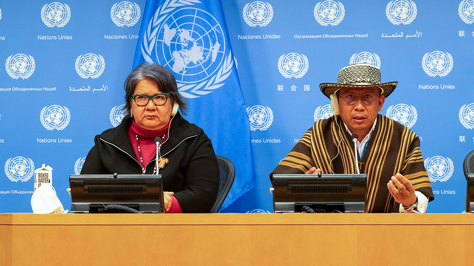
Darío José Mejía Montalvo, Chair of UN Permanent Forum on Indigenous issues and Leader of the National Indigenous Organization of Colombia, (right) speaks from New York. Left, National Chief of the Assembly of First Nations RoseAnne Archibald.
Grist / Tristan Ahtone
The World Bank, hypothetically, could institute a policy whereby it only funds projects in countries maintaining clear FPIC regulations. In addition to national level recommendations, these are the kinds of policies that Ibrahim hopes the forum will develop during this session.
Majo Andrade Cerda, a Kichwa member of the Global Indigenous Youth Caucus from Ecuador, said that her peoples’ territory is threatened by gold mining projects. The country, she observed, needs a significantly stronger application of FPIC to defend Indigenous land and rights. “When you have FPIC programs and you respect that right, you are respecting our autonomy and how we decide to live,” she said.
Developing those programs will be a challenge that requires direct input from Indigenous communities. “We have to reinforce the idea that FPIC has to be done with intercultural points of view,” she said.
Cerda also stressed the difference between consultation and consent — consultation only requires nations to notify Indigenous communities of their actions; consent requires their active approval. Her hope is that Ecuador and other countries will look to the standard set by the UNPFII and other U.N. bodies to develop their own strong FPIC laws, rather than writing weaker versions that only require consultation.
Fawn Sharp, President of the National Congress of American Indians and Vice President of the Quinault Indian Nation, believes that broad policies like the RESPECT Act are important because they hold governments to a high standard in interactions with all tribes. However, she also said that there need to be provisions within these laws that give Indigenous communities options to dictate those consultations based on their needs and traditions. “It should be a general process that will work and that’s enforceable, but then flexible enough to ensure that each sovereign nation and its protocols are respected,” she said.
Sharp also said that a meaningful application of FPIC will require the United States to treat tribal nations as equals. “If we’re going to have meaningful consultation, we have to have political equity, which means there’s an equal bargaining position,” Sharp said. “The United States can’t just consult, check the box, then proceed with unilateral action.”
Another key part of the process is a mechanism that Indigenous groups can turn to when a project proceeds without their consent. Sharp believes UNPFII is an opportunity to learn from international examples of what that dispute resolution mechanism might look like.
Jose Proaño, co-director of Land is Life, is working directly with Indigenous communities in South America to develop the type of frameworks Cerda and Sharp describe. Proaño says that Indigenous communities already have their own established practices for decision making. FPIC is merely a way of providing a procedure to help the government engage with them. “The protocol is just a framework of what has been happening in this territory for thousands of generations,” he said.
Those procedures also help to guide governments on how to respectfully and appropriately communicate with Indigenous groups. In the past, he says, corporations and governments have done insufficient and disrespectful consultation processes. “It’s not consultation,” he said. “It’s just like a check mark.”
Silje Karine Muotka says that as the world moves towards greener energy sources, it needs to listen to Indigenous peoples, rather than continue to violate their rights and land. “You can’t camouflage the policies that we have endured for so long with global warming and lack of biological diversity,” she said. “If you are going to solve the main problem, then you must take another direction.”
This story is published as part of the Global Indigenous Affairs Desk, an Indigenous-led collaboration between Grist, Indian Country Today, and High Country News.
Indigenous communities around the world face an alarming quartet: state violence, human rights abuses, harmful conservation practices, and extractive industries. All these issues and more will be addressed at the 21st session of the United Nations Permanent Forum on Indigenous Issues (UNPFII), which convenes today at U.N. headquarters in New York.
The forum is a rare opportunity for the international Indigenous community to set a high standard for respecting Indigenous land, rights, and culture and create clear recommendations for the U.N. and its member states. Geoffrey Roth, a Standing Rock Sioux descendant and forum member, says that it is an opportunity to advocate for Indigenous issues and people on a global scale, specifically projects that require the consent of communities.
“We can really be an example to the world’s leaders in how to preserve the environment,” Roth said.
The forum also serves as an important platform for young Indigenous leaders. Victor A. Lopez-Carmen, Yaqui, and enrolled with the Crow Creek Sioux Tribe, is a student at Harvard Medical School and Co-Chair of the U.N. Global Indigenous Youth Caucus. He says that the forum is especially important because of the way it allows Indigenous people from around the world to compare experiences and unite on shared issues.
“Our values are going to push us towards more innovation,” he said. “There aren’t many organizations that can deliver a global statement.”
Indigenous and human rights leaders participate in the 15th session of the U.N. Permanent Forum on Indigenous Issues, Monday May 16, 2016 at U.N. headquarters.
AP Photo/Bebeto Matthews
Established in 2000, UNPFII is an advisory agency to the United Nations’ Economic and Social Council with representation from seven regions: Africa; Asia; Central and South America and the Caribbean; the Arctic; Central and Eastern Europe, Russian Federation, Central Asia and Transcaucasia; North America; and the Pacific.
Climate migration and conflict will be a key issue throughout the session. Impacts from climate change—including floods, crop failures, and increased temperatures—have forced many Indigenous people to move from their homelands. According to a report from forum members, Indigenous communities in the Sahel and the Congo Basin have been acutely impacted, leading to migration and conflicts over water access and land claims. Competition over resources like Lake Chad, which lost 90 percent of its surface area and water volume over the last 60 years, is leading to conflict between communities in the area.
Ongoing violence against Indigenous people will be another major topic with twin crises present across the globe: missing and murdered Indigenous people and violence against Indigenous land defenders. Reem Alsalem, the Special Rapporteur on violence against women, will present on the subject. Alsalem is working on a report on violence against Indigenous women and girls, which will be presented at the U.N. Human Rights Council this summer. “Eliminating violence against women is a human rights obligation of states,” she told The New Humanitarian. Indigenous people have also been the victims of violent and illegal conservation efforts in the Democratic Republic of the Congo, Cameroon, Brazil, and other places. With the support of foreign governments and international organizations, Indigenous people have been murdered, abused, and driven from their lands in the name of protecting the environment.
In the middle of an international effort to transition to greener energy, Indigenous people continue to bear the brunt of harmful resource extraction. According to a member report, the transition to cleaner energy needs to happen quickly, but in a way that respects and consults with Indigenous communities. According to the report, Indigenous peoples are not an obstacle to development, but may have a different idea of what development should look like. Calling for a new global covenant with Indigenous people, the report says that, “Transferring responsibility and sacrifice to groups of people who are the most vulnerable and are excluded from energy policies is not the right way to address the crisis caused by increased climate variability.”
Benki Piyano (C), Shaman of the Ashaninka of the Amazon, speaks at an event of the United Nations Permanent Forum on Indigenous Issues, highlighting new and emerging efforts to protect the planet’s rainforests and their defenders, on April 23, 2019 in New York City.
JOHANNES EISELE/AFP via Getty Images
Recently, Indigenous knowledge and culture has received wider recognition and appreciation from non-Indigenous people. While this is a positive step, a member report argues that the international community needs to create stronger protections for Indigenous intellectual property. The report says that “The knowledge, wisdom, tools and methods used by indigenous peoples to solve their problems have been passed on, and should continue to be passed on, as a legacy, not only to future generations, but to the whole of humankind.” Indigenous knowledge and expertise with biodiversity, for example, will be a key part of conserving and protecting the environment. Indigenous people need to lead these efforts however, or they risk exploiting or stealing their intellectual property. According to the report, this would amount to a human rights violation.
Around the world, Indigenous languages have been under threat for generations. International experts estimate that as much as 95 percent of today’s spoken languages—many of which are Indigenous—could be extinct or seriously endangered by 2100. To draw attention to the issue, the U.N. declared 2019 as the Year of Indigenous languages, which led to over 800 activities, including technology development and youth education. To make language protection and revitalization more sustainable, the U.N. launched the International Decade of Indigenous Languages, which starts this year. Members and invited experts, like Cherokee Nation Principal Chief Chuck Hoskins Jr., will talk about ways to increase Indigenous language access and education around the world.
UNPFII serves as a mechanism for Indigenous issues to be integrated more broadly within the United Nations system, but is also key to advocating for the U.N. Declaration on the Rights of Indigenous Peoples (UNDRIP), a non-binding resolution that affirms the rights of Indigenous people around the world. Passed in 2007, UNDRIP was initially opposed by the United States, Canada, Australia and New Zealand but has since been adopted in those countries as well as over a hundred others around the world. However, while the resolution has been met with support, most of its key provisions have yet to be codified into the legal systems of member states.
Over the course of its 10 days, UNPFII will be tasked with providing advice and recommendations to the U.N. on ensuring that Indigenous peoples’ rights are protected. Last year’s final report recommended the adoption of legal mechanisms to create stronger human rights protections as well as highlighting global inequalities exacerbated by the COVID-19 pandemic. The report also raised concerns that efforts to achieve sustainable development goals did not include Indigenous communities and drew attention to various Indigenous rights abuses around the world. Those concerns, and their handling by the international community, will be revisited and evaluated in this year’s session.
“Our hammer,” said Geoffrey Roth, “is this final report, which gives recommendations to the U.N. agencies on how to interact and correct things in these nation states and Indigenous communities.”
About two weeks after Russia invaded Ukraine, a metal that plays a key role in batteries for electric vehicles, or EVs, was thrust suddenly into the spotlight. On March 8, the price of nickel doubled within hours on the London Metal Exchange, prompting the world’s leading metals market to shut down trading for the material. The price spike occurred amidst fears that nickel from Russia, the world’s third-largest producer of the metal, would soon become “untouchable due to sanctions risk,” as one group of analysts put it.
More than a month later, the hypothetical sanctions that helped fuel metals market chaos have yet to materialize. And an emerging supply chain that connects Russian nickel with the European EV market — most notably through a partnership between mining giant Nornickel and German chemical company BASF — remains intact for now. But the war in Ukraine, and Russia’s totalitarian crackdown on dissenting voices, have major implications for that supply chain as well as an Indigenous-led movement for environmental justice that targets Nornickel’s polluting practices.
For the European EV industry, the situation raises difficult ethical questions and highlights the competing demands of geopolitical, social, and environmental responsibility in a time of war. In recent weeks, Germany has come under growing pressure to sever more of its economic ties with Russia in order to punish Putin for his brutal war in Ukraine. But if the nation were to ban imports on Russian nickel, an industry that is essential to Europe meeting its climate goals, it would have to scramble to secure new sources of a critical raw material. At the same time, Russian Indigenous activists fear they would lose one of the few levers they have for holding Nornickel accountable: its relationships with Western companies.
“We’re in a situation of contradictory demands,” said Tilman Massa, a member of the Association of Ethical Shareholders Germany, an NGO that campaigns for environmental protection and human rights due diligence at German corporations. On the one hand, Massa says, companies are facing intense public pressure to cut ties to Russian business. “On the other hand, we now have leverage to increase the pressure on Nornickel to improve the situation on the ground.”
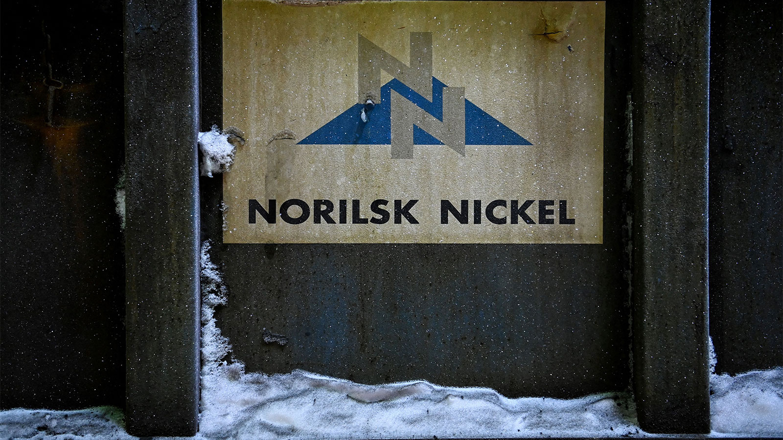
A defunct smelter owned by the Russian mining giant Nornickel in the town of Nikel, Russia. KIRILL KUDRYAVTSEV / AFP via Getty Images
Nornickel, the world’s largest producer of the high-grade nickel needed for EVs, isn’t a huge player in Europe’s battery supply chain today. But it is expected to become one in the future thanks to a strategic partnership with BASF that the companies announced in 2018. Through that partnership, Nornickel will supply both high-grade nickel and cobalt from its metal refinery in Harjavalta, Finland, to BASF’s nearby battery materials plant, which is scheduled to come online this year. According to Caspar Rawles, an analyst at the battery market research firm Benchmark Mineral Intelligence, BASF is expected to represent nearly 20 percent of Europe’s battery cathode production capacity by 2025, with raw materials supplied by Nornickel.
The EV industry needs nickel and cobalt to create the long-lasting, high-performance batteries Western consumers increasingly demand. Nickel, in particular, is essential for boosting the energy storage capacity of batteries, extending an EV’s range. As a result, the world’s appetite for the metal is expected to skyrocket in the coming decades: According to the International Energy Agency, producing enough batteries for EVs and energy storage to limit global warming to 2 degrees Celsius could cause global nickel demand to rise 21-fold by 2040.
But Europe, a leading consumer of these batteries, doesn’t have many local nickel suppliers.
“The dilemma that European battery and EV makers face is: do they want to use the Nornickel-BASF nickel supply chain, or to rely for the bulk of nickel imports from Indonesia and China,” Benchmark CEO Simon Moores wrote in an email to Grist. The latter options, Moores notes, raise serious environmental and social concerns for the EV industry: nickel mining in Indonesia has been tied to severe deforestation, while China is currently under intense scrutiny for alleged human rights violations in its renewable energy supply chains.
BASF acknowledged this dilemma in a statement to Grist. “If we were to end our collaboration with Nornickel on nickel supply, an important value chain for the European production of batteries for electric vehicles would be interrupted,” BASF told Grist in an emailed statement. “[T]here are currently no alternatives for locally sourced nickel in Europe.”
But nickel mining in Russia isn’t free of environmental or human rights concerns. Nornickel’s production sites and refineries in the Russian Arctic are a major source of regional air pollution; a 2017 NASA article described a “man-made volcano” of sulfur dioxide lingering over the industrial city of Norilsk, where company facilities are located. Indigenous people living in the shadow of Nornickel say that the mining giant’s activities have poisoned their land and water, making it impossible for them to fish and hunt reindeer in their traditional territories.
After a major oil spill from a tank owned by Nornickel contaminated waterways around Norilsk in 2020, Indigenous activists stepped up their efforts to raise awareness of the mining giant’s impacts. In late 2020 and early 2021, a coalition of activists from Russia and allied international organizations sent letters to BASF airing their grievances about Nornickel and asking the German company to hold it accountable. BASF, activists say, listened to the coalition’s concerns, beginning an “intense and productive dialog” that continued up until the war, according to Pavel Sulyandziga, the president of the Batani Foundation, one of the Russian Indigenous groups in the coalition.
As this activist pressure was mounting, Nornickel reached out to the Initiative for Responsible Mining Assurance, or IRMA, expressing interest in becoming a member. A multi-stakeholder organization that develops environmental and social standards for the mining sector, IRMA offers membership to companies after they conduct a self-assessment of their practices followed by a third-party audit of at least one of their mines within a year.
Indigenous activists were encouraged by these developments — but now they fear Russia’s war is eroding any progress they had made. Since Russia invaded Ukraine, Sulyandziga says the coalition has had no contact with BASF or Nornickel. Meanwhile, Russian media reports and decrees indicate the government is working to relax environmental regulations, including postponing new requirements around emissions monitoring and emissions quotas for polluters, and declaring that negative environmental reviews cannot halt projects.
In March, IRMA formally paused its plans to audit Nornickel this spring. IRMA executive director Aimee Boulanger told Grist that decision was based on the organization’s desire to stay aligned with the message the world was sending about doing business in Russia, as well as concern that people living around Nornickel’s mine sites would be unable to speak with auditors safely.
There are valid reasons for IRMA’s concern. Speaking out about polluting industries in Russia was a risky proposition before the war; in wake of Russia’s recent crackdown on dissent, it has become even more dangerous. Sulyandziga told Grist that criminal cases have recently been filed in Russia “against the very Indigenous communities and representatives who have been in opposition to Nornickel all along” and that police have begun cracking down on those communities by confiscating reindeer meat they sell in order to support themselves.
Reached for comment, Nornickel spokesperson Andrey Kuzmin said that the company “never paused and always remains open for dialogue” with Indigenous communities. Nornickel, Kuzmin added, regularly holds meetings of a council of Indigenous representatives the company set up last year to discuss economic development, educational projects, and more. Critics like Sulyandziga, however, say that this council represents a cynical attempt by Nornickel to buy loyalty by providing support to communities who agree not to speak out against it.
Andrei Danilov, the director of the Sámi Heritage and Development Fund, which represents Sámi people of the Russian Arctic and is a member of the activist coalition, told Grist he hopes that BASF can convince Nornickel to “restart the dialog” with its critics. BASF told Grist that while the company is engaged with Nornickel it plans to remain in touch with Indigenous activists in addition to “encouraging Nornickel to directly engage.” While BASF has stopped pursuing new partnerships with Russian businesses, it will continue to fulfill its contracts with Nornickel “in line with applicable laws, regulations and international rules,” according to the company.
But that could change should Germany or other European countries impose sanctions targeting nickel or metals from Russia.
“It could be any day that Nornickel is on the sanctions list,” said Massa of the Association of Ethical Shareholders Germany. In early April, Nornickel’s billionaire president, Vladimir Potanin, was hit with Western sanctions for the first time.
Vladimir Potanin, the billionaire president of Nornickel, in London in 2017. Mikhail Svetlov / Getty Images
The conflicting pressures BASF and the European EV industry face with respect to Russian nickel are a microcosm of a challenge the entire world faces as the clean energy transition ramps up: how to balance securing the metals and minerals needed for that transition with the environmental and social harms caused by mining. It’s a difficult enough balancing act in times of peace; as Russia’s war shows, global conflict has the potential to further tip the balance of power away from frontline communities.
That’s why some climate justice advocates are now calling for an entirely new approach that situates mining not as a centerpiece of the energy transition, but a single approach within a broader suite of solutions including increased battery recycling and expanding mass transit to reduce demand for EVs. Where mining does occur, these advocates stress that it needs to be done responsibly and with full buy-in from affected communities.
“I don’t think we know where this [war] is going right now and what that means for the world,” IRMA’s Boulanger told Grist. “But in a time of violence and political crisis, we need environmental and social justice all the more.”
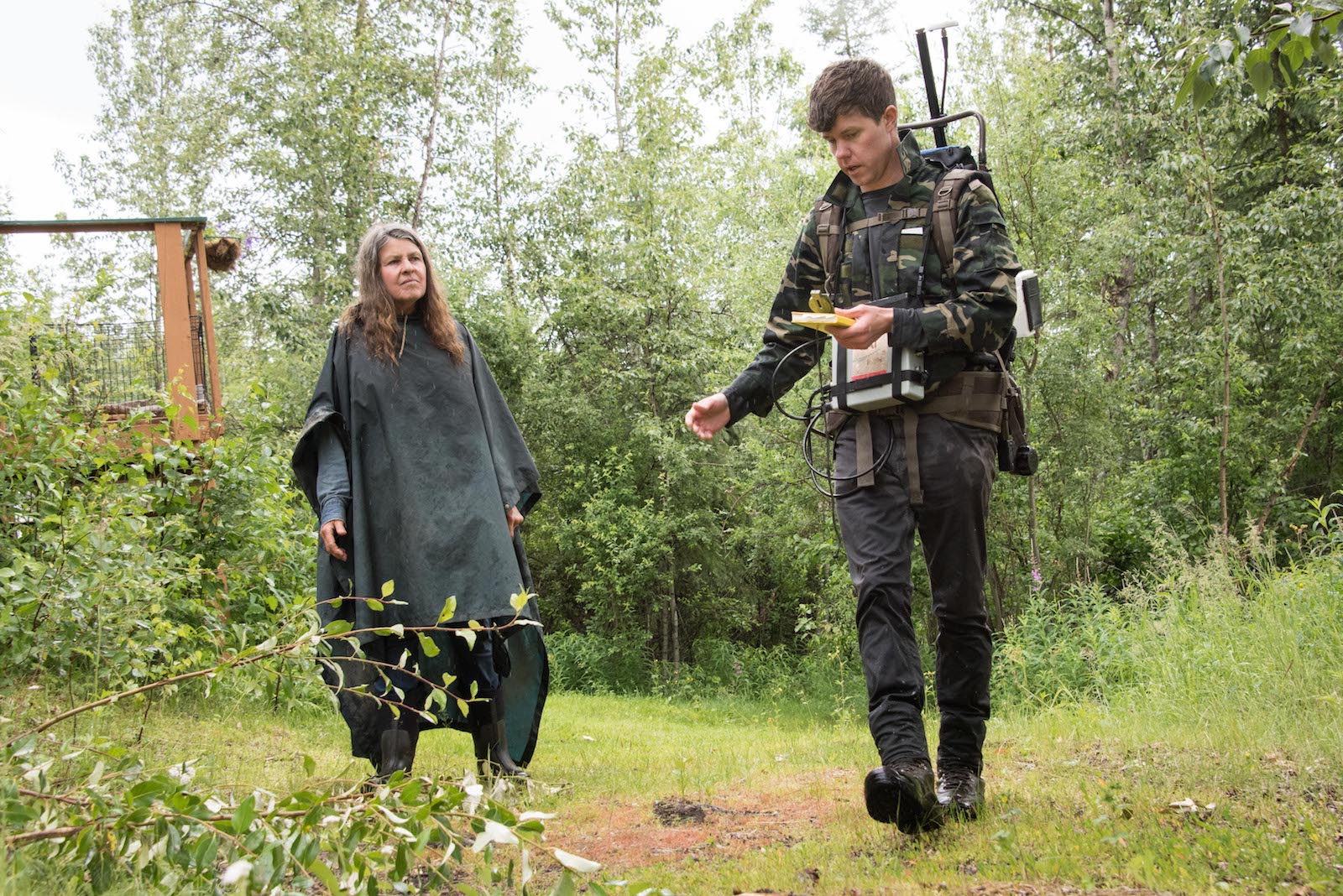
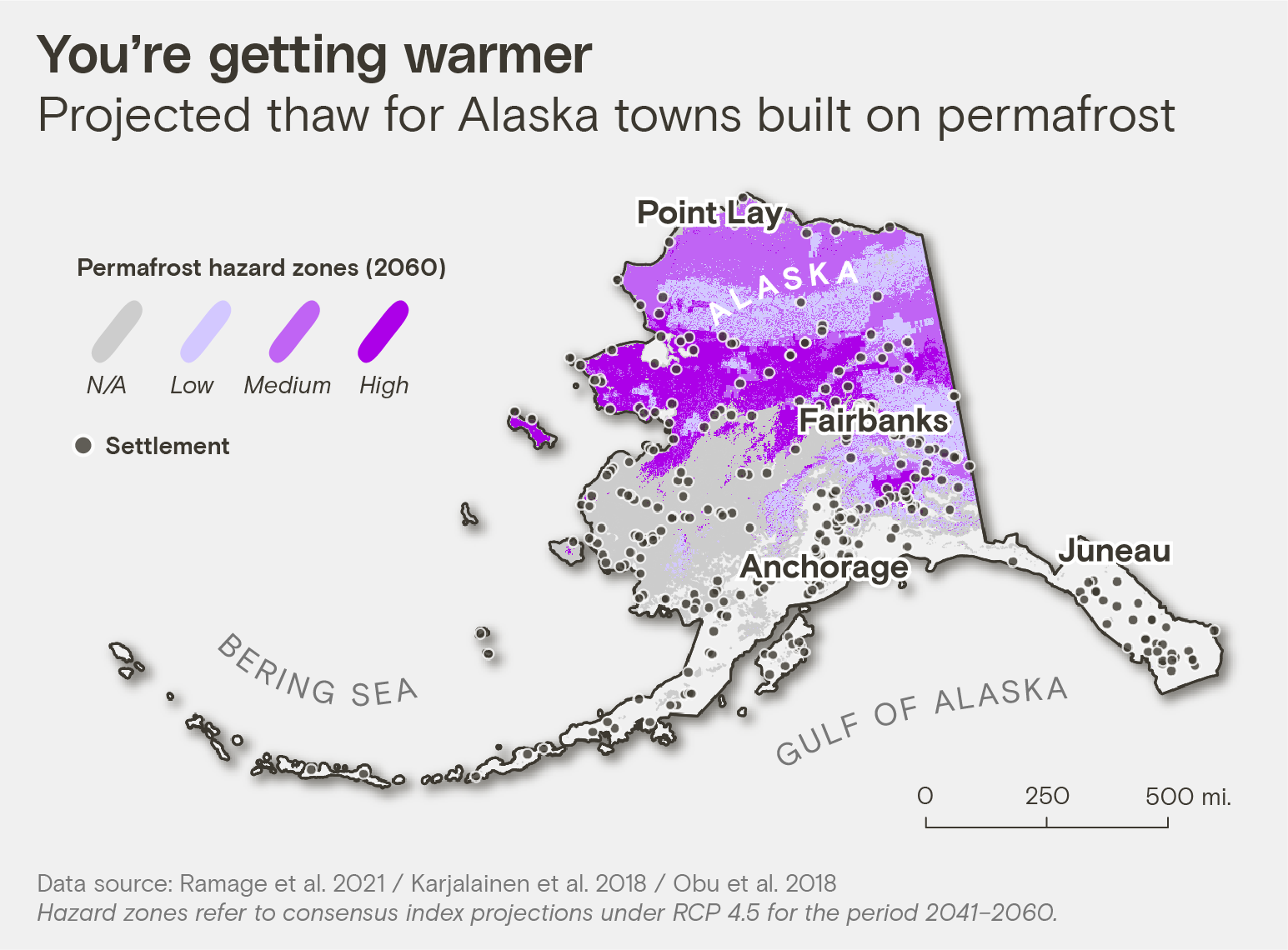
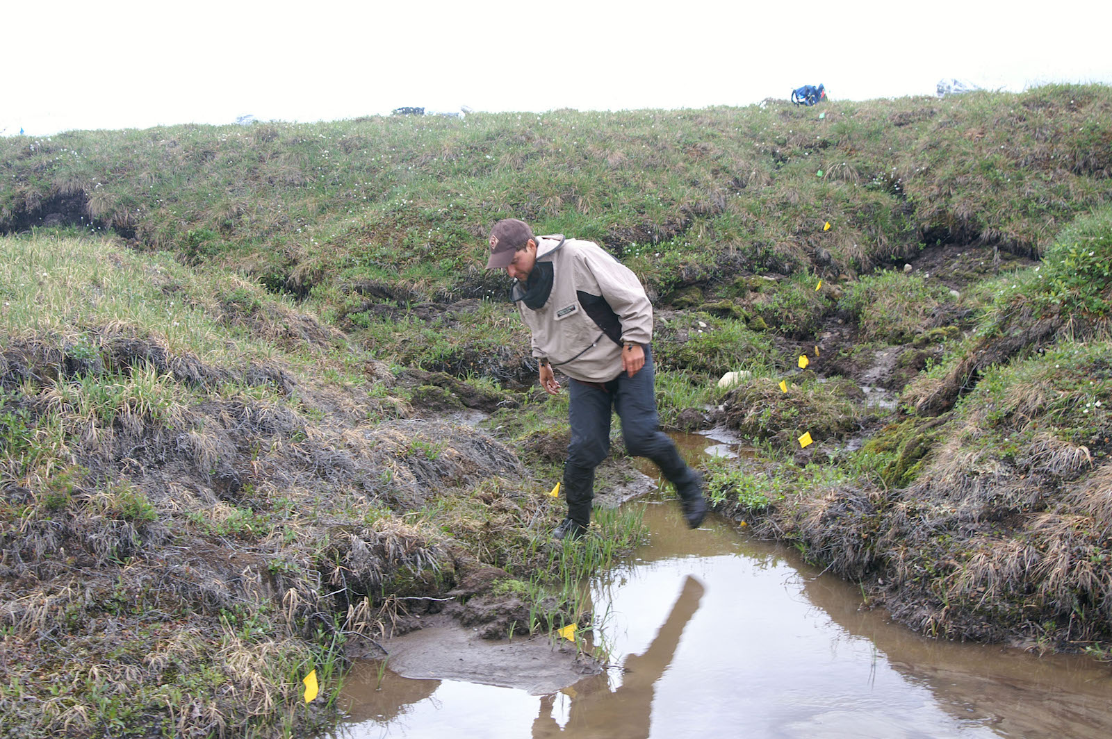
Kathy Lenniger was running her dogsled team one day along her usual route in Fairbanks, Alaska, when she suddenly splashed into overflow, fresh water spilling on top of the snow. Surprised and chilled, she returned to the parking lot, where a lanky man was loading a sled with science equipment. Nicholas Hasson, it turned out, was studying thawing permafrost — research that could shed light on the streams and sinkholes that recently materialized around Lenniger’s property and all around town.
Lenniger lives in a log cabin in Goldstream Valley, a spruce-lined swale with a rolling view of the Northern Lights near Fairbanks. “It’s the birthplace of American permafrost research, actually,” said Hasson, a Ph.D. student at the nearby University of Alaska Fairbanks, or UAF. During World War II, the military feared the ribbons of dancing light were interfering with its radar, so Congress passed an act in 1946 establishing the Geophysical Institute at UAF. Soon, scientists were investigating the strange phenomena in the sky and drilling boreholes around Goldstream Valley to study the frozen ground beneath their feet.
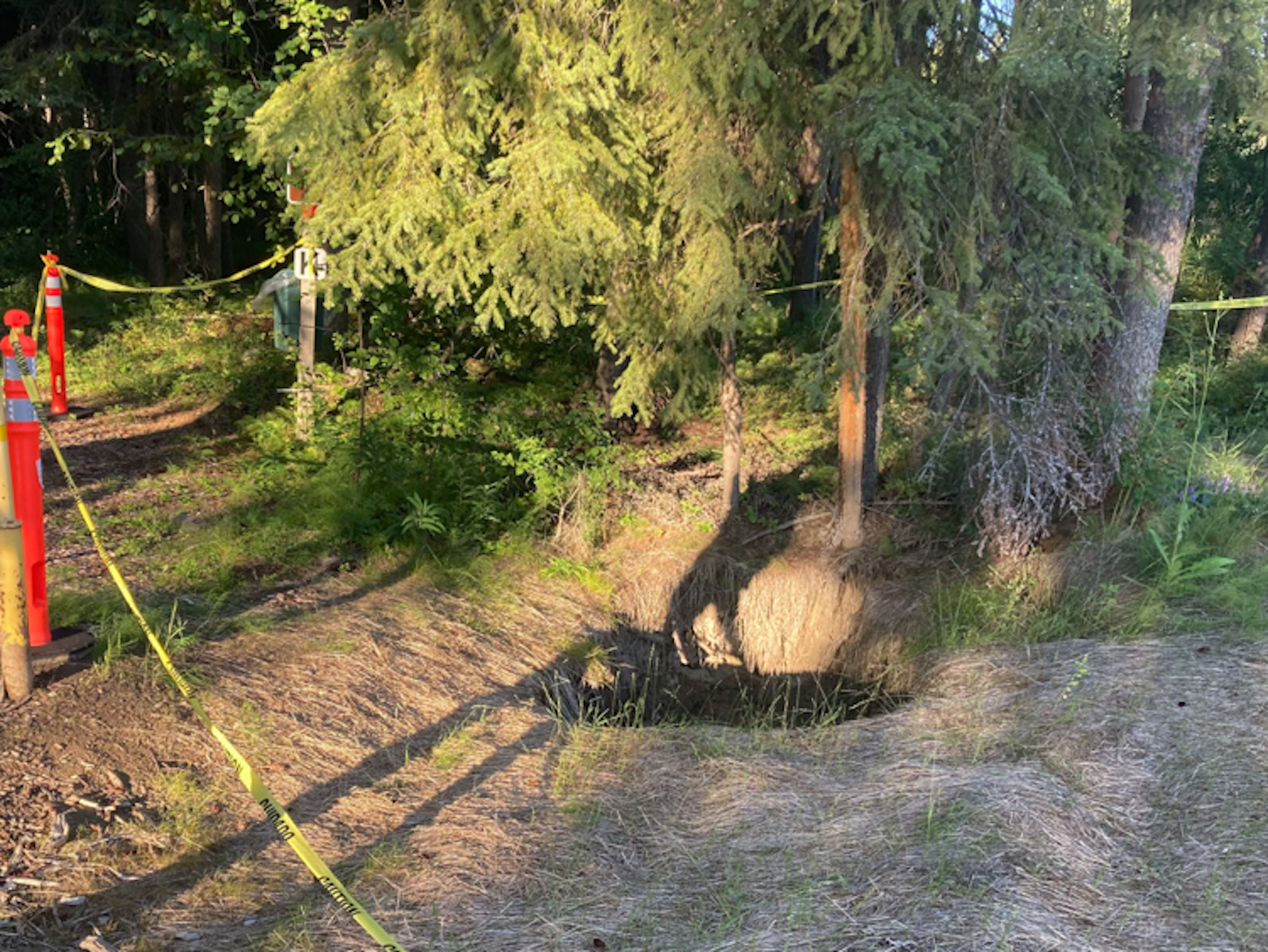
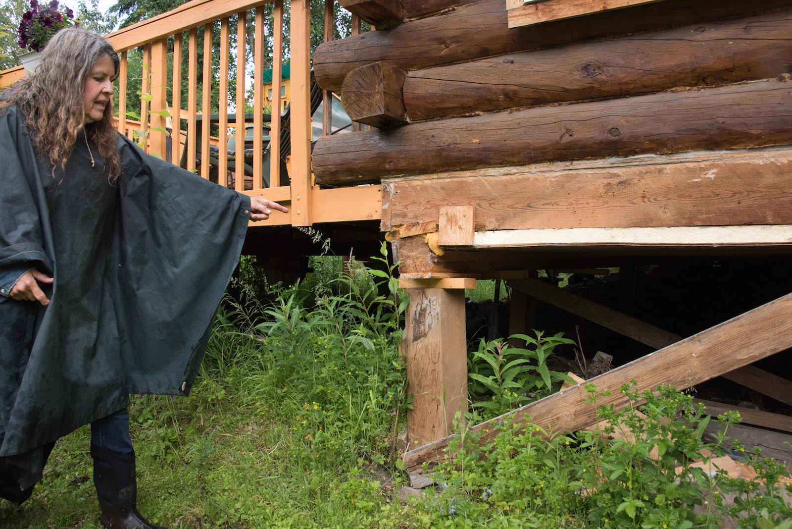
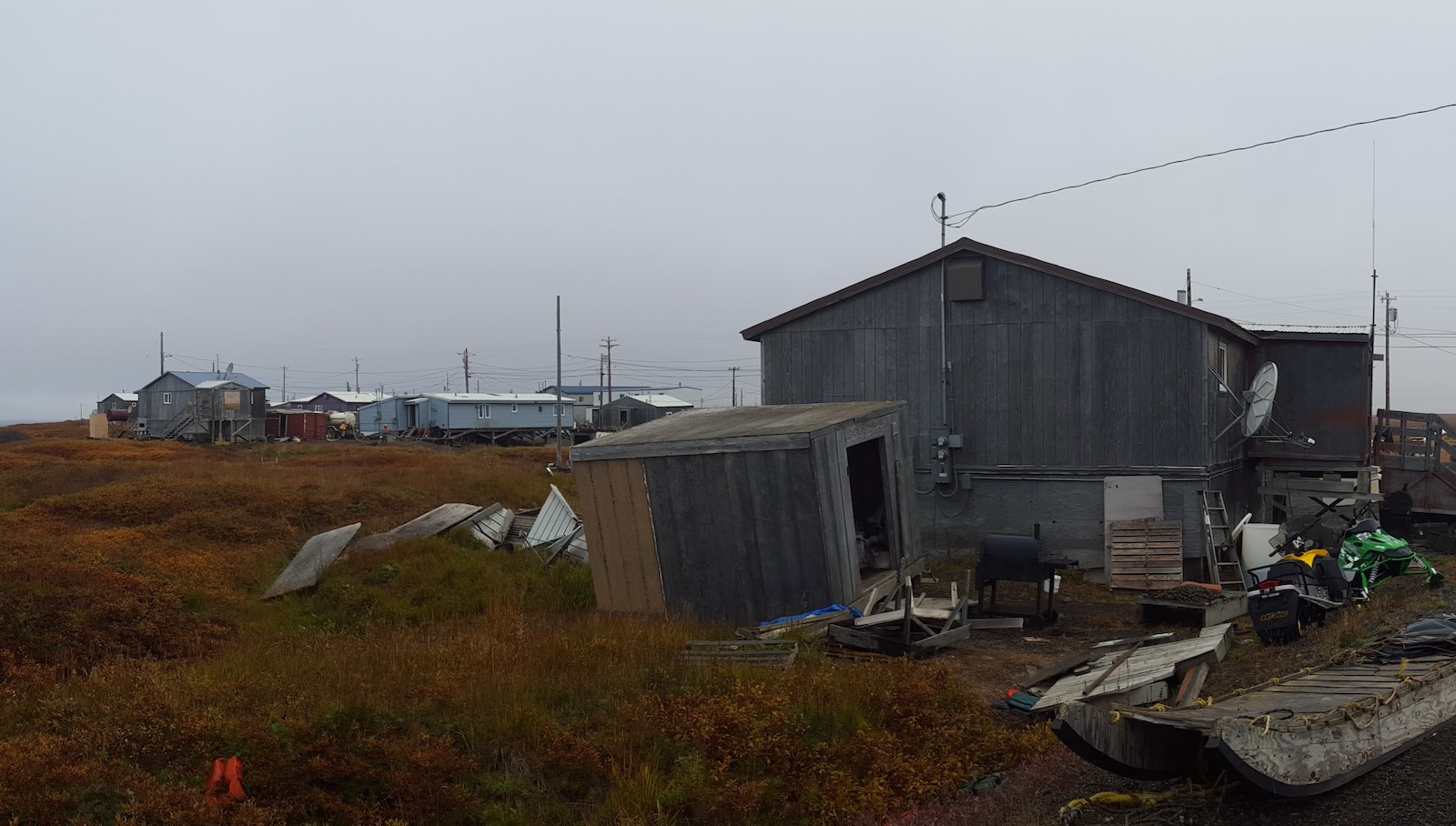
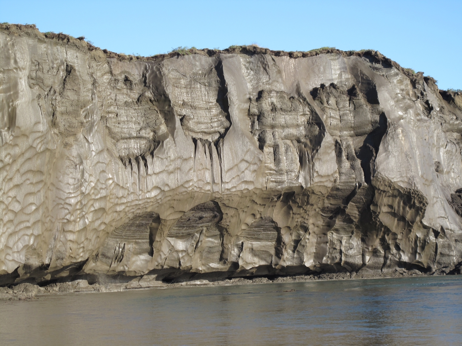
Since then, temperatures in Fairbanks have shifted so much that the National Oceanic and Atmospheric Administration officially changed the city’s subarctic designation in 2021, downgrading it to “warm summer continental.” As the climate warms, the ancient ice that used to cover an estimated 85 percent of Alaska is thawing. As it streams away, there are places where the ground is now collapsing. Many of the valley’s spruce trees lean drunkenly. Sometimes, only a thin layer of soil covers yawning craters where the ice has vanished, what Hasson calls “ghost ice wedges.” Its absence has already fundamentally changed how — and where — people can live.
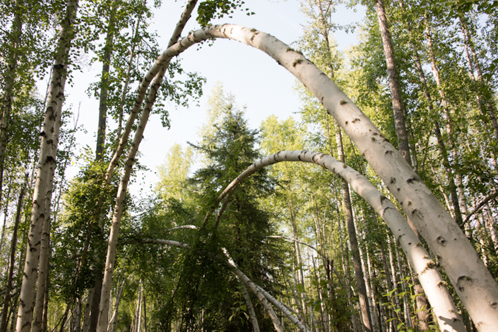
Birch trees, left, bend as the ice below them melts near the University of Alaska, Fairbanks. Collapsing trees are one of the more visible signs of permafrost; as ice thaws, the ground can slump, moving enough to overwhelm trees with shallow root systems. Right, Caution tape surrounds a large sinkhole caused by melting permafrost. Photos by Sean McDermott / Grist.
When Lenniger built her cabin several decades ago, she didn’t expect she’d need to regularly jack up her foundation. But for the last several years, she said, “if I have some water on my counter now, it rolls in this direction. It’s like, ‘Oh yeah, it’s sinking again.’” At first, she tried to fill the sinkholes popping up around her property with bones from the meat she fed her sled dogs, but eventually the pits grew large enough to strand a backhoe. Despite living in perhaps the most-studied permafrost valley in the country, Lenniger didn’t know how much worse her troubles might get — until Hasson offered to help.
On a muggy afternoon last summer, Hasson prepared to try to find out why Lenniger’s cabin was sinking. He pulled on a backpacking frame he’d jury-rigged to receive very low-frequency radio waves from antennae in Hawaii, recording the modulations of the electric field to map the permafrost beneath the duff. The colors of the aurora come from the charged particles of solar wind, which collide with oxygen and nitrogen in the Earth’s ionosphere and create a glowing halo. The free electrons from these collisions can reflect radio waves, helping Hasson understand how permafrost is thawing below the surface. Combined with a $40,000 laser he dragged behind him on a plastic sled he’d nicknamed “The Coffin,” Hasson is able to link surface methane emissions to the ice disappearing underground.
As he scrambled off Lenniger’s driveway into the brush, Hasson explained, “It’s just like an MRI — we’re able to scan and see where water is flowing.” Walking across her yard, he found a new underground river had formed under a corner of Lenniger’s home, which explained why her land had caved in.
Researcher Nicholas Hasson, right, talks with Kathy Lenniger, left, a property owner in Fairbanks’ Goldstream Valley. Permafrost melt is creating sinkholes and undermining the structural integrity of homes, wells, septic systems, and roads.
Sean McDermott / Grist
The permafrost around Fairbanks is discontinuous; jagged pieces of it finger north-facing slopes and enfold the low-lying valleys. Yet potential homebuyers who want to avoid it are left to guesswork. “There’s no comprehensive map of permafrost,” said Kellen Spillman, the director of the department of community planning for the Fairbanks North Star Borough. For those like Lenniger, whose properties later develop thaw-related problems, there’s little recourse, either from insurance or the government. The University of Alaska Fairbanks, home to much of the state’s permafrost research, has itself struggled with recurring sinkholes on its roads and parking lots. “We have invested funding to rebuild,” said Cameron Wohlford, director of design and construction at the school’s facilities, “only to have them fail.”
Homeowners around Alaska’s second-largest city are facing expensive repairs, or even having their properties condemned. Hasson eventually traced the river running beneath Lenniger’s property to her neighbor’s, where the owner, Judy Gottschalk, reported that her septic pipes had broken as the ground settled. “My well went out this winter, too,” she said. Not knowing where else the ghost ice lies, Gottschalk has been nervous about putting in a new septic system. The drilling and construction required to replace it would cost her as much as $45,000, more than she originally paid for her house. “Everyone I know is having problems with their housing,” Lenniger said.
As parts of Alaska set record high temperatures in December, Fairbanks closed out 2021 with a destructive ice storm, causing roofs to collapse. A warmer Arctic is also a wetter Arctic, accelerating the breakdown of permafrost, explained Tom Douglas, a senior scientist for the U.S. Army Corps of Engineers’ Cold Regions Research and Engineering Laboratory, in Fairbanks. “For every centimeter of rain, we see about one centimeter of additional top-down thaw,” he said. On average, Fairbanks now sees about five more weeks of rain than it did in the 1970s.
Kathy Lenniger points to the back corner of her house, where she has had to add wood to the foundation’s posts in order to keep her home level. Sean McDermott / Grist
“In my 47 years here, I’ve never seen these kinds of conditions before,” Lenniger said. She has a lot of practice finding creative ways to take on Alaska’s hurdles: Before phone lines went in, she and her partner used homing pigeons to communicate while mushing, though she said she was unfazed when the birds were devoured by owls. But now, the rapid changes are testing her ability to cope. “Every day, it’s like now what will happen?”
Just as the earth clings to its former shape, leaving a record of where ice used to be, the very language used to describe these changes is revealing. The word permafrost, after all, is simply an abbreviation of “permanently frozen ground.” Much of Alaska’s permafrost is tens to hundreds of thousands of years old, first frozen when Goldstream Valley was grazed by mammoths. Now, that sense of immutability is slipping. “It was thought to be permanent — that any changes happened on a scale of tens of thousands of years,” said Vladimir Romanovsky, a professor emeritus of geophysics at the University of Alaska Fairbanks and a leading permafrost researcher.
Many variables influence permafrost’s stability, like how cold it is, how deep it runs, and the quantity of soil moisture, or its “ice richness.” In some parts of Alaska, ice extends nearly a half-mile below the surface, while in others, it has formed the landscape itself, sprouting tundra-covered ice hills called pingos.
Rising temperatures have caused structural problems for the 800-mile Trans-Alaska Pipeline System, seen here in aerial view. The pipeline has experienced “slope creep” as a result of thawing permafrost. Sean McDermott / Grist
Since 1993, Romanovsky has been taking field data from stations around the state, recording their increasing temperatures. At all of the 350 stations, soil temperatures have warmed substantially, and thaw is inching down to deeper depths. On the North Slope, one of Alaska’s coldest ice-rich regions, “when we started it was about -8, and now it’s -4 degrees Celsius, so we’re already halfway to zero,” he said. Dramatic changes will increase once this melting point between frozen and liquid is hit. He predicts that within 40 years, the Slope will be “at a critical threshold in normal, undisturbed conditions.”
Off the North Slope, this tipping point will be reached sooner. Any time soil or vegetation is disturbed — as the Army Corps of Engineers discovered in 1942 while trying to build a highway to Alaska — permafrost has a tendency to disintegrate into truck-swallowing mud. It’s a similar story with roads built in recent decades. Jeff Currey, materials engineer for the northern region of Alaska’s Department of Transportation & Public Facilities, explains that as ice wedges degrade under the state’s highways and airports, the asphalt heaves and drops, creating a dangerous roller-coaster effect. Because Alaska has relatively few roads across its 665,000 square miles, the ones it has are critical connections.
“Warming temperatures are contributing to increasing maintenance and damage,” Currey said. “Anecdotally, we’re having to fix the same places more frequently, and more intensively.”
Mitigation measures can help, from the low-tech approach of using gravel to channel cold air against embankments to high-tech thermosiphons, tubes that channel warmth aboveground during the winter to help keep the soil frozen. But Alaska’s budget for maintenance is largely dictated by the state legislature, and Currey calls the annual $330 million allotted to the northern region in recent years “inadequate.” Currey explains the average road is typically built to last around 30 years, but that’s largely based on expected traffic, not whether the road will be thermally stable. An independent study published in the Proceedings of the National Academy of Sciencesestimated that, as a result of climate change, the state will have to spend billions more on maintaining and repairing public infrastructure by the end of the century. Despite budget shortfalls, Currey predicts that “maintenance efforts simply have to increase.” In many cases, “we’ll tolerate rougher and worse roads than we do now — that will just be the economic reality.”
Grist / Clayton Aldern
Around Fairbanks, elevating buildings to keep their heat from leaking into permafrost or designing structures to be adjusted isn’t new. Re-leveling houses as a cheap way to adjust to moving ground is an Alaskan tradition. “My grandparents used to chase the corners on their cabin when it moved, like everybody,” said Aaron Cooke, an architect and researcher at the National Renewable Energy Laboratory’s Cold Climate Housing Research Center, who has worked on these issues in many communities around the state. But with climate change, the old engineering tricks that helped keep permafrost frozen aren’t sufficient. “The ground is changing, even if you do everything right.”
To understand the scale of the impact when it starts to melt, Cooke said, you have to understand that “to someone in the north, the natural state of the ground, the default status of Earth, is frozen. And thousands of years of culture are built on that knowledge.” While the impacts of permafrost thaw — subsidence, flooding, sinkholes, and landslides — mimic the devastation of natural disasters, the Federal Emergency Management Agency isn’t responsible for permafrost damage, and it’s difficult to get covered by homeowner’s insurance. “How fast does a disaster need to move for a department that handles disasters to address it?” Cooke asked.
Romanovsky predicts that within a decade, the destruction in most parts of Alaska will get worse. “I’m worrying about my house as well,” he said. But regions with continuous and ice-rich permafrost, like those in northwest Alaska, will see the worst damage. “It will be the major problem driving relocation,” he said, “but these changes need to be understood at high resolution — for each village, for each house, you need to know what to expect.”
Where the Chukchi Sea bites into the North American continent, ice loss has driven thousands of walruses to the beaches of Point Lay, in northwest Alaska within the Arctic Circle. The predominately Iñupiat community, home to around 300 people, is wrestling with the loss of ice, too: In 2016, the lake they relied on for drinking water disappeared overnight after the ice wedge it rested on eroded, forcing the town to pump water from a nearby river. This year, one of the town’s holding tanks failed, spilling almost a million gallons. “Apparently, permafrost was melting under us,” said Lupita Henry, the Native Village of Point Lay’s former tribal president. “There are cracks in homes, doors that can’t close, houses that are so angled they seem unlivable.”
Now 40 years old, Henry was a young girl when the town’s first underground sewer lines were put in; many of them have since broken as the ground settled. The borough government recently installed new electric poles, which are already starting to lean. Like in many rural Alaskan communities, there’s a shortage of housing, but Henry said the thawing permafrost makes it difficult to build or even get a loan for a new home. “Where do you get your insurance? Through which bank can you finance to even get your home fixed?” she asked. “When the ground is falling underneath you, what do you do?”
The Native Village of Point Lay is a predominately Iñupiaq village of about 300 people on the northwest coast of Alaska. Andrea Medeiros / U.S. Fish and Wildlife Service
In 2018, the state recognized a new hazard: usteq, a word from the Alaska Native Yup’ik language that describes the catastrophic land collapse stemming from thawing permafrost, and the erosion and flooding it entails. As sea ice disappears, the coast has been battered by intensifying storm surges, speeding the breakdown of permafrost under the shore. Riverbanks are corroding from thaw, changing everything from the chemistry of the groundwater to its distribution and movement. Permafrost, Henry said, “is linked to everything — our homes, water sources, food sources, vegetation.”
Point Lay is now working with researchers on a Navigating the New Arctic project, funded by the National Science Foundation, to try to determine the best engineering for building on its ice-rich and unstable ground. It’s all complicated by the fact that the remote town can only be reached by plane or barge, making construction more difficult. Even before the pandemic, supplies were regularly delayed. “All of the problems overlap,” said Jana Peirce, the project’s coordinator. Point Lay can apply to FEMA’s Building Resilient Infrastructure and Communities program for help in adapting to permafrost thaw; the federal agency is now proactively trying to intervene, because the cost of responding to emergencies is, on average, six times more expensive than mitigation. But to do so, Point Lay will need an up-to-date hazard mitigation plan, and to form a plan, they need to know where the ground ice is, and how it might melt. “While there is no question that planning is important for smart adaptation,” Peirce said, “for a small community already living in crisis, this is just another hurdle.”
In the 2019 Alaska Statewide Threat Assessment, which set out to summarize the risks permafrost presents, Point Lay is ranked as one of the top three communities under threat from permafrost thaw. Yet aid has been slow in coming. “You tell them you need a water source, that your land is melting underneath you — how many meetings do I have to have until I’m given funding?” Henry asked. In March 2022, Point Lay became the first town in Alaska to declare a climate emergency, acknowledging the threat to their existence.
Erosion from permafrost thaw, as seen here, is a common problem for communities in Northern Alaska. Courtesy of Mikhail Kanevskiy / University of Alaska Fairbanks, Institute of Northern Engineering
Towns across Alaska are facing similar challenges: The statewide threat assessment found that 89 of Alaska’s 336 communities are threatened by permafrost degradation. “The main barriers to addressing these threats include the lack of site-specific data to inform the development of solutions, and the lack of funding to implement repairs and proactive solutions,” Max Neale, senior program manager for the Alaska Native Tribal Health Consortium, wrote in an email. “We have yet to see significant engagement from state and federal partners to improve the efficacy and equitability of programs for communities facing climate change and environmental threats.”
In 2020, the U.S. Government Accountability Office found that federal assistance for climate migration has been ad hoc, and that the federal government is nowhere near prepared for the scale of relocation required. Cooke says temperate parts of the world simply don’t seem to have registered the urgency of Arctic change. He’s spent over a decade racing to help relocate Alaskan towns like Shishmaref or Kivalina, which, despite being deemed in imminent danger back in 2003, have not yet completed their move. But when he attends climate change conferences, “it’s very jarring to hear people still talking in the future tense.”
For many Alaskans, the emergency is already here. “If we can get a good idea of how much permafrost we’re sitting on top of,” Henry said, slowly, “we can try to get the federal government to help us with mitigation, or decide if we have to relocate.” Although facing a crisis, people in Point Lay are used to the idea of building for an uncertain future. “Don’t put any pity on us,” Henry said. “We’re strong people who survived thousands of years — and we will continue surviving.”
The scale of the problem is daunting, but there’s surprisingly little agreement on how much dealing with a thawing Arctic will cost. Over a dozen experts interviewed for this article admitted they weren’t sure how many Americans live on permafrost; a recent paper published in Population and Environment suggested a ballpark of around 170,000 people. Nor can anyone agree how much ice is where, much less how it might thaw.
Nearly a third of Arctic research is based on data from just two field stations: Abisko, Sweden, and Toolik Lake, Alaska. And researchers usually collect data during the Arctic’s short summer field season, even though winter conditions may look very different, making conclusions less accurate. For instance, recent studies have found that emissions of carbon and methane released by thawing permafrost have been drastically underestimated. There are 1.6 trillion metric tons of carbon currently stored in permafrost — twice what’s now in the atmosphere. New projections suggest that the amount of greenhouse gas emissions from permafrost could equal those emitted from the rest of the United States by the end of the century.
A researcher at Toolik Field Station charts the collapse of ground on the Alaskan tundra after frozen underground soil thawed.
Scott Canon / Kansas City Star / MCT via Getty Images
“It’s clear that the models are not capturing all the key pieces,” said Anna Liljedahl, a climate scientist at the Woodwell Climate Research Center, who is based in Homer, Alaska.
Research attempting to settle these questions generally falls into one of two camps. There’s top-down, like Liljedahl’s work with the Permafrost Discovery Gateway, which uses high-resolution satellite imagery to record thaw slumps and surface water changes. Machine learning and supercomputers have helped Liljedahl closely map visible ice wedges, creating a more comprehensive view of the Arctic, but can only infer what’s under the surface through identifying types of soil or vegetation.
The second approach is bottom-up: Romanovsky’s boreholes, for instance, deliver very detailed measurements from specific places, but researchers have to extrapolate to draw larger conclusions. Yet all permafrost is not equal. Take a type of permafrost called yedoma: frozen, silty muck from the Pleistocene era that releases 10 times more greenhouse gases than other types of thawing ice. Additionally, research indicates yedoma-rich regions may be warming the most quickly. So knowing how much yedoma there is, and where, is critical.
Scientists like Hasson hope to advance a third approach using airborne imaging spectroscopy, essentially mounting a fancier version of the laser on his sled to planes, a more efficient research method. This technique can detect large methane emissions, and Hasson can then use very low radio frequencies to identify what’s happening below the surface, identifying methane hotspots and providing information on the scale that infrastructure planning requires.
Nicholas Hasson carries very low-frequency radio equipment mounted on a framepack so he can walk through Alaska’s forested terrain and create a map of the subsurface to help understand where giant ice wedges are melting beneath the ground. Sean McDermott / Grist
“The question is, why aren’t we doing this method at scale?” Hasson said. “Why am I not in a plane right now flying over Alaska?” The Department of Energy considers permafrost thaw and its emissions a threat to national security, and is partly funding Hasson’s research, along with NASA and the National Science Foundation.
Much is at stake. Dmitry Streletskiy, a geographer at George Washington University, explained that long before ice begins to thaw, warming decreases permafrost’s ability to support structures. In the spring of 2020, the 800-mile Trans-Alaskan Pipeline reported its first instance of “slope creep,” as thawing permafrost jeopardized its structural integrity. That’s likely what happened in the Siberian city of Norilsk a few months later, where thawing ruptured a huge fuel reservoir, prompting a cataclysmic diesel spill that dyed the region’s rivers blood-red.
Streletskiy started his career focused on ecosystems, but realized that “unless you put monetary values to things, it doesn’t get much attention. His most recent study found that 70 percent of major Arctic infrastructure is in areas that permafrost thaw could put at risk of damage within the next 30 years, increasing maintenance costs by $15.5 billion dollars, as well as causing another $21.6 billion in damages. And those are the paper’s most conservative estimates.
While Russia likely has the lion’s share of the world’s population living on permafrost, alpine countries like France and Switzerland will also see mountain slopes start to lose their stability, resulting in hazardous landslides. A recent study published in Population and Environment found that 3.3 million people currently live in settlements where permafrost will degrade by 2050, forcing many to relocate.
“Those who live on permafrost have a pretty good understanding of what will happen in 20 years — they don’t need scientists to tell them,” Streletskiy said. “It’s the people who live in D.C. or Moscow who need to pay attention.”
Up the rippling highway from Lenniger’s cabin in Goldstream Valley, Sam Skidmore shoveled dirt away from a vault door at his gold mine, the entrance to the deepest permafrost tunnel in Alaska. He’d decided to break his rule against opening it when the temperature was above freezing so Hasson could take ice samples. Skidmore stumped down into the darkness, his headlamp gleaming off ice crystals as he passed a wooly mammoth skull poking out of the wall. As they continued deeper, gravel beds betrayed warning signs of past eras, when dramatic warming transformed the landscape. “We’re literally walking back in time,” Skidmore said.
Skidmore and Hasson walk through the permafrost tunnel collecting soil and ice samples.
Sean McDermott / Grist
They descended between alternating layers of gravel and silt, passing eons when interior Alaska was an endless grassland steppe and eras when a changing climate shaped the landscape into more familiar forests. “Where we are now [in time], Homo sapiens hadn’t entered America,” said Skidmore, who is preserving the tunnel for research. Hepoked at a particularly pebbled section, saying it would take “a horrendous amount of rainfall to take all the trees and silt away and make a new layer of gravel like this.”
Today, the Arctic is again confronting dramatic change: As the region’s permafrost continues to thaw, some areas of Alaska will sink and get wetter, while others may dry out and burn, transforming habitats. Other studies show that permafrost under the ocean itself is thawing, reshaping the seafloor, forming craters the size of city blocks and elevating new pingos. For humans and animals alike, responding will be a balancing act, said Dmitry Nicolsky, a research associate professor at the Geophysical Institute in Fairbanks. Hazards will combine to create cumulative effects: As wildfires increase, for instance, people are told to cut vegetation away from their houses. “But making a safety buffer in Fairbanks might also cause permafrost degradation,” Nicolsky said.
Almost above Skidmore and Hasson’s heads, on the other side of the tunnel’s glistening roof, was one of the countless lakes that dot Alaska’s interior. In January at 40 degrees below zero, Hasson can drill into its frozen surface and light the escaping methane plumes into towering columns of fire. The lake is also releasing mercury, a toxic metal that could now be accumulating in Alaska’s water sources, as well as radon gas. Other ponds may emit neither, highlighting the importance of identifying not only where greenhouse gases are likely to be released, but new sources of hazards for human health.
Even in attempting to tally these changes, researchers may underestimate nature’s complexity. Liljedahl explained that when ice-rich tundra degrades, it can slump and become a pond. As it fills with moss, a very effective insulator, the underlying permafrost sometimes recovers, eventually filling up the depression with a bonus layer of new organic soil. “Instead of losing, it’s gaining,” she said. “We can’t lock ourselves into the idea that it can only go in one direction.”
Emerging back into the light, Skidmore stared out over the hills, where pockets of birch marked where mining operations disturbed the permafrost a century ago, creating pools and altering the forest. The catastrophic flooding revealed within his tunnel will happen again, he mused. “It’s only a matter of time.”
This story was originally published by Grist with the headline Don’t Look Down on Apr 20, 2022.
Following years of escalating violence by illicit mining operations in the Amazon, Brazil’s Ministry of Justice and Public Safety has sent federal police, a joint military-civilian unit, environmental inspectors, and representatives from the government’s Indigenous affairs agency to protect Indigenous people, seizing illegal gold mining equipment and machinery on the Iriri River in Xipaya territory. The operation comes in the midst of growing Indigenous advocacy and a hard-fought presidential election.
Located in Northern Brazil, the region is home to roughly 200 Xipaya people who have faced displacement by the construction of a hydroelectric dam and violence. For over a decade, illegal gold mining has led to mercury-contaminated waters, deforestation, murders, rape and sex-trafficking in Indigenous lands and communities. Recently, a group led by other Indigenous people, armed by miners, killed two Yanomami people and wounded five others.
Last week, the Coordinating Body of Indigenous Organizations of the Amazon Basin, or COICA, which represents Indigenous organizations across nine countries in the Amazon basin, declared a state of emergency for Indigenous land defenders. Citing over 200 murders of Indigenous rights defenders, the declaration calls on governments and the United Nations to help secure the right for Indigenous people to protect their land.
According to a new report by the Hutukara Yanomami Association, an Indigenous advocacy group, illegal gold mining has increased across the Amazon and skyrocketed on Yanomami land, the largest Indigenous territory in Brazil and north of Xipaya territory. Known as Garimpos, the relatively small-scale, illegal mines destroyed more than 8,000 acres of rainforest in 2021 representing a 46 percent increase in mining from 2020.
In the first three months of 2022, deforestation in the Amazon has set a new record according to the Brazilian National Institute for Space Research. From January through March of this year, the rainforest saw more than 360 square miles of deforestation — a 64 percent increase from last year and the highest total during that time period since data collection began in 2015.
Earlier this month, thousands of Indigenous people marched in the capital of Brasilia to demand a halt to legislation put forward by President Jair Bolsonaro that would open Indigenous land to commercial mining and agriculture. According to opinion polling, Bolsonaro is trailing former President Luiz Inácio Lula da Silva for the upcoming presidential election this October with 80 percent of voters saying that protecting the Amazon should be a priority for candidates and that plans to protect it would increase their chances of election.
This story was reported in collaboration with NAJA and NPR’s Next Generation Radio: Indigenous.
Rights of Nature – an innovative legal movement that protects water, animals and ecosystems by giving them legal rights – might stop a pipeline.
In 2018, Frank Bibeau, an attorney for the White Earth Nation, helped the tribe write a law that recognized the rights of wild rice, which they call Manoomin, or “good berry”, to “exist, flourish, regenerate, and evolve.” The law relies on a section of an 1837 treaty between the Ojibwe and the U.S. government.
In Minnesota, wild rice, and the waters it depends on, are in danger from climate change and the expansion of Line 3, a controversial pipeline operated by a Canadian energy company and fiercely opposed by Indigenous people and environmental activists. The pipeline’s proposed corridor would run directly through wild rice beds and could threaten the environmental health of the whole area. In 2021, he used the Rights of Manoomin law to sue the State of Minnesota over the construction of the pipeline.
“I couldn’t figure out how to get authority over them to compel them to do anything we might want to do. And right in my brain, you know, it just clicked,” Bibeau said. “Wild rice is mentioned specifically in the 1837 Treaty. It talks about how we retain the rights to hunt fish and gather wild rice on the lakes and rivers and lands that we’re ceding. Well, that’s huge.”
In a setback for the case in March, the White Earth Ojibwe Appellate Court dismissed the tribe’s own lawsuit. The ruling said that the court does not have jurisdiction over non-tribal member activities on off-reservation land. The case is still awaiting a decision from a Federal appeals court over that exact question.
Since Bibeau first developed Rights of Manoomin, other tribes have used it as a model. In 2019, the Yurok Tribe in Northern California adopted a resolution recognizing the rights of the Klamath River. In Seattle, the Sauk-Suiattle Indian Tribe is suing the city over its hydroelectric dams on behalf of salmon. Bibeau believes that these two cases will be the next step in the growing Indigenous Rights of Nature movement and have the potential to lead to widespread use by tribes across the country.
In the Kahuzi-Biega National Park in the Democratic Republic of the Congo, park guards and Congolese soldiers, with support from international conservation groups, have undertaken a brutal, three-year campaign to violently remove the Indigenous Batwa people who call the park home. That’s according to a new report by Minority Rights Group International, a London-based human rights organization.
With support from the World Conservation Society, US Fish and Wildlife Service, and the US Agency for International Development, Congolese security forces have destroyed villages, murdered at least 20 residents, group raped at least 15 women, and displaced hundreds of Batwa in the name of conserving and protectingKahuzi-Biega National Park, or PNKB. Batwa are an Indigenous people with communities throughout Central Africa and have inhabited the area that is now PNKB since time immemorial.
The report alleges that funding, material support, and training provided by international organizations and US agencies violate a UN Security Council arms embargo as well as other international laws. Minority Rights Group International also alleges that organizations and agencies were aware of the attacks on Batwa, which took place between 2018 and 2021, and did nothing.
Lara Dominguez, Acting Head of Litigation at Minority Rights Group International and a lawyer representing Batwa, says the report helps to illustrate the fundamental problems with the global conservation model, which she says is fundamentally racist and hasn’t led to any real conservation.
“The PNKB’s donors and international partners demonstrated a flagrant disregard for international law and the rights of the Batwa people,” said Colin Luoma, an author of the report. “It casts serious doubt as to whether these actors are willing to place human rights at the center of their conservation work.”
(left) One of many homes burnt and destroyed in a major attack targeting Batwa villages in July 2021. (right) Shell casings from the rifles used by park guards and soldiers left behind at a village that was destroyed in the July 2021 attacks.
Robert Flummerfelt / Minority Rights
The park was established in 1937, when the country was still a colony of Belgium, by Belgian decree. But even after independence, the newly established Democratic Republic of the Congo opted to expel Indigenous Batwa communities from the park’s boundaries at the behest of Belgian conservationist Adrien Deschryver who lobbied the government to expand the park. Batwa were neither compensated for their land nor given a new place to live. Instead, they were forced to settle on the outskirts of the park, where they faced persecution and discrimination. An estimated 50% of the population died in the two decades following expulsion.
“Since we were expelled from our lands, death is following us,” said a Batwa community leader at the time. “We bury people nearly every day. The village is becoming empty. We are heading towards extinction.”
In October 2018, fed up with decades of persecution and broken promises, Batwa began returning to the forest. But the response was swift and brutal: In February 2019, park guards began working with the Congolese military, efforts that were coordinated by General Charles Mundos, who had been sanctioned by the UN Security Council in 2018. In April 2019, PNKB’s Director, De-Dieu Bya’Ombe reportedly issued a public ultimatum to all Batwa in the park to leave or be killed.
Since then, the report’s authors have documented three waves of violence and displacement: the first in July-August 2019, the second in July 2021, and the third in November-December 2021. The report describes it as an “escalating campaign of terror and violence intended to expel Batwa from their ancestral home and deter their return.”
According to the report, attacks involved joint contingents of park guards and Congolese army soldiers using mortars and rocket-propelled grenades to destroy villages. They also subjected Batwa women to group rape at gunpoint, burned Batwa alive, and mutiliated corpses. Based on eyewitness accounts from Batwa and park guards, the report says that at least 20 Batwa were murdered in these attacks. The true number may be much higher because many Batwa fled into the forest and were never seen again. It is believed they may have starved to death.
In 2015, the US Fish and Wildlife Service partnered with the Wildlife Conservation Society, or WCS, to improve law enforcement and wildlife security in the park. WCS worked with Maisha Group Limited, a private security company founded by an Israeli special forces operative, to provide training through 2017. About two months after the August 2019 attacks, the WCS brought a law enforcement consultant to the park to train park guards on weapons, combat, and patrol.
The Democratic Republic of the Congo is under a legally binding arms embargo by the United Nations Security Council, which means that member states providing “assistance, advice or training related to military activities” must notify the UN. The UN Security Council was not notified of any of these activities, which the report claims puts the Wildlife Conservation Society and US Fish and Wildlife in violation of the arms embargo.
Headstone of one of several Batwa community members killed in July 2021 attacks conducted by park guards and soldiers. According to eyewitnesses, the Mutwa buried here was killed execution-style while members of his family watched.
Robert Flummerfelt / Minority Rights
Kahuzi-Biega National Park is a popular tourist destination where visitors from around the world pay over $1000 per person for safari tours to see gorillas. The park is a UNESCO World Heritage Site, recognized as an exceptional habitat for rainforest and gorillas. The UNESCO citation says “Although the greater part of the property is inhabited, some villages were included in the Park at the time of its extension in 1975, creating disputes with the populations. These problems must be resolved to strengthen the effectiveness of conservation actions.”
The World Conservation Society is a nonprofit that owns or supports parks and conservation projects around the world. In the US, that includes the Bronx Zoo, New York Aquarium, and the Central Park, Queens, and Prospect Park Zoos. In 2020, WCS apologized for its long history of racism and promised to do better.
In a statement, WCS said, “We strongly reject accusations that WCS was complicit in any of the alleged abuses described in the report. We are confident that all our activities in and around KBNP have been helpful and constructive to this end, and in full respect of the rule of law and human rights.” The statement also accuses Minority Rights Group of “numerous false accusations,” including any support or training of military forces.
A spokesperson for US Fish and Wildlife said that “The U.S. Fish and Wildlife Service takes all allegations of human rights abuse seriously,” but did not respond to specific allegations about its role in the violence. A USAID spokesperson said that they are concerned about the situation and concrete steps need to be taken to address the management challenges in the park. USAID also said that its support for PNKB ended prior to the alleged incidents.
Lara Dominguez says that international complicity in violence against Batwa is an indictment of the way many conservation programs operate. “There’s no interest in actually informing themselves about what’s going on the ground,” she said. “What I see is a culture of willful blindness and plausible deniability.”
Minority Rights Group International reports that Batwa are still displaced from their homeland, facing poverty and persecution.
In April of last year, José de Jesús Robledo Cruz and his wife Maria de Jesús Gomez Vega were found dead in the desert in Sonora, Mexico. In July, Fernando Vela, a doctor in Coqueta, Columbia, was shot to death by two men on a motorcycle while he was in his truck. In September, Juan Macababbad, an attorney in the Philippines was shot dead outside his home.
In each case, the victims were prominent human rights defenders, known in particular for defending their communities’ natural resources from mining, deforestation, water contamination, and other threats. These were just three of at least 76 such murders that occured in 2021.
That’s according to a new report by the nonprofit Business and Human Rights Resource Centre, or BHRRC. The organization tracks attacks on people who protest or otherwise raise concerns about business-related human rights abuses. It has documented more than 3,800 attacks, including killings, death threats, beatings, arbitrary arrests and detention, and lawsuits, since January 2015, with 615 occurring in 2021 alone.
“Our data shows almost the tip of the iceberg,” Christen Dobson, senior program manager for the BHRRC and an author of the new report. “Many attacks are not publicly reported. And so we know the problem is much more severe than these figures indicate.”
According to the report, human rights defenders who spoke out against mining projects consistently experienced the greatest number of attacks over the past seven years. The authors say this is especially concerning considering the expansion of mineral production required by a transition to clean energy. All those batteries, solar panels, and wind turbines are going to require a lot of cobalt, nickel, zinc, lithium, and other minerals.
“We’re already seeing this level of attack, and we’re not seeing major producers of transition minerals have strong policies or practices in place about protecting defenders,” said Dobson. “There’s a real risk there and I think it’s an area that we’re very concerned about.”
The BHRRC has documented attacks in every region of the world, with the attacks disproportionately affecting Indigenous peoples, who make up five percent of the global population but were victims of 18 percent of attacks against human rights defenders in 2021. The report cites racism as an underlying driver of attacks, but it also points to the failure of companies to seek the free, prior, and informed consent of Indigenous peoples when pursuing projects that may affect an Indigenous community or their land. The authors estimate that at least 104 attacks in 2021 stemmed from a failure by companies to effectively consult with communities or gain consent before starting projects.
The report urges investors to publish a human rights policy and require that companies begin disclosing human rights and environmental-related risks. But Dobson said that voluntary actions from companies and investors was not enough. She said there was some momentum building behind mandating that companies report on measures they are taking to respect human rights, including legislation proposed in the European Union and Canada.
“It is concerning to see a vast majority of companies and investors, including major renewable energy companies, do not have policies expressing zero-tolerance against reprisals in their operations, supply chains and business relationships,” said Dobson in a statement. “It’s time for companies and investors to recognise the energy transition cannot be effective if it is not also rights-respecting.”
When he was 10 years old, Terry Supahan’s mom bought him a new bike. Supahan, a member of the Karuk Tribe in Northern California, had only ridden second hand bikes before. A hundred years earlier, the state of California had stolen millions of acres of land from his tribe and more than a hundred others. In 1968, the state sent checks to individual Indigenous people to pay them back. Supahan’s mom used the money she received — about $100 he recalls — to buy the bike, a moment that Supahan remembers fondly, but laughs at now. How could a bicycle compare to millions of acres of stolen land?
The check was part of a $29 million land settlement for roughly 65 million acres of land — two-thirds of the entire state — stolen from Indigenous people. That works out to less than 50 cents per acre, a price unheard of even in the 19th century, when the United States first began gobbling up Indigenous land.
“I’ve tasked our administration with seeking out ways to support California Native peoples in accessing, co-managing, and acquiring your ancestral lands,” said Newsom in a meeting with the state’s Indigenous Truth and Healing Council, a group of tribal leaders who are examining the state’s treatment of tribes and making recommendations for reparation. “Today we’re making a down payment on this commitment.”
Newsom’s announcement comes in the middle of an attempt by California to repair relations with Indigenous people after centuries of genocide. The effort began in earnest in 2019, when Newsom apologized to Indigenous communities on behalf of the state for California’s long history of violence, discrimination, and land theft. The buy-back announcement also comes amid the growinglandback movement, but has elicited mixed reactions from Indigenous leaders.
Governor Newsom at the future site of the California Indian Heritage Center in West Sacramento, CA.
AP Photo/Rich Pedroncelli
“It’s a baby step in the right direction, but I have a lot of questions,” said Joely Proudfit, a descendant of the Pechanga Band of Luiseño Mission Indians and the director of the California Indian Culture and Sovereignty Center at Cal State San Marcos.
On the one hand, experts say, the $100 million program could help tribes conserve land and serve as a pilot for future programs in California and other states. The money could make an important impact on tribes’ capacity to protect the environment. On the other, it could quickly run out of money and lead to few meaningful changes, eventually becoming another empty gesture on behalf of the state.
Today, Terry Supahan is executive director of the True North Organizing Network, a social justice group that is working with tribes to reclaim land, among other projects. He says Newsom’s proposal is welcome but that the state must do more. “As much as I believe the governor’s initiative is an important step in the right direction, it is not enough,” he said. “There’s just too many wrongs that are going to have to be addressed.”
In California, a violent colonial history has left many tribes fragmented and underfunded, and both tribes and the state say returning control to Indigenous people to continue stewardship is crucial to protecting and preserving the environment. Indigenous people have been recognized as the best caretakers of land around the world. According to the United Nations, although Indigenous people are only five percent of the world’s population, their land contains 80 percent of the world’s biodiversity.
“Let’s face it, this is California: $100 million goes nowhere,” Proudfit said. “It’s a drop in the bucket.”
With real estate prices so high, it’s worth asking why the state doesn’t just give land directly back to tribes. Wade Crowfoot, California’s secretary for natural resources, said that direct transfer is a mechanism the state is exploring, specifically in the north, where the planned removal of four dams on the Klamath River may create surplus land that could be transferred to the Yurok and Karuk Tribes. But California owns relatively little land, roughly 3 percent of the state, while the remainder is more or less evenly split between the federal government and private owners. So in the absence of large chunks of available state land, and without clear legal mechanisms for distributing it to tribes, a landback fund would allow tribes to acquire privately held properties.
Fish traps used to catch and document the health of salmon on the Klamath River on the Yurok Reservation.
AP Photo/Nathan Howard
The program, which is part of the governor’s annual budget proposal, will need to be approved by the state legislature in June and would be managed by the California Natural Resources Agency. The governor has not released any details on how the money would be allocated and which limitations might be placed on it. Members of the state’s Truth and Healing Council have raised concerns about the proposal creating conflict between tribes competing for limited land and questions about how the money would be distributed to unrecognized tribes. Crowfoot acknowledges that there are many open questions about how the program will work.
“I don’t want to oversell,” he said. “This is complex and unprecedented. There’s a lot that we’re going to learn along the way.”
California has a uniquely brutal story in the history of American colonization. Peter Burnett, the first governor of California, declared in 1851 that “a war of extermination will continue to be waged between the two races until the Indian race becomes extinct.” Under Burnett and subsequent leaders, California sponsored militia-led massacres across the state, enslaved Indigenous people, and tried to erase their culture. The federal government also stole Indigenous land through 18 treaties made with Indigenous nations that were never honored and have still not been ratified by Congress.
Under Newsom’s proposal, the money could also be used to help tribes implement climate adaptation programs or hire staff. Michael Hunter, chairperson of the Central California Tribal Chairpersons Association and chairman of the Coyote Valley Band of Pomo Indians, says that the governor’s proposal is a “great concept” but that the challenge will be in its execution. Working with state agencies and navigating the bureaucratic process could take years, he said. “Until we follow through to change the direction the environment is going, landback is just landback. But if we do it properly, we could turn the cycle around in California,” he said.
Hunter, who recently organized a rally to urge the state to sign a co-management agreement with Pomo tribes for Jackson Demonstration State Forest, is encouraging the state to transfer as much state land to tribes as possible. Financial support, he believes, could best be used to help maintain those lands. Tribes, he says, have the solutions to climate change. The state just needs to get out of their way.
Crowfoot, who is not Indigenous, said that Newsom’s 2019 apology was “powerfully symbolic” but required action to become meaningful. The new proposal, he believes, is an example of that action. Crowfoot says that he is focused on making this initial funding successful to pave the way for future investment. “I’m confident that if this funding proves to be effective in terms of building tribal leadership on conservation, that additional funding would be allocated in the future,” he said.
But California could certainly afford a bigger commitment now. The state is currently expecting a budget surplus of $45.7 billion, $20.6 billion of which is in a general fund for discretionary purposes.
Whatever happens, Terry Supahan hopes that this proposal will lead to more meaningful investment than a new bicycle.
It’s been more than 350 years since the Rappahannock Tribe was forcibly removed from its ancestral lands on the Chesapeake Bay in present-day Virginia. Now, it’s finally getting some of its land back.
Rappahannock Tribe members were joined by conservation leaders and U.S. officials — including Interior Secretary Deb Haaland — on Friday to commemorate the return of a 465-acre parcel of land that was seized by European settlers in the 17th century. The return of the land, which has been restored to its original name of Pissacoack, is “a historic victory for conservation and racial justice,” the tribe said in a statement.
The news marks the culmination of a yearslong collaboration between conservationists and tribal members to protect the area and restore it to its original owners. Besides its reputation as one of the Chesapeake Bay’s most beautiful places, the region’s bluffs and wetlands provide important habitat for fish and migratory bird species — some of which have cultural and religious significance to the Rappahannock. Bald eagles, for example, descend upon the area by the hundreds each year as part of their annual migrations.
“You can sometimes see 40 eagles in the span of a couple hours,” said Joel Dunn, president and CEO of the nonprofit Chesapeake Conservancy.
The 465-acre parcel of land that was donated to the Rappahannock Tribe has been restored to its original name, Pissacoack.
Chesapeake Conservancy
Dunn’s organization helped lead efforts to restore Rapphannock ownership of the land following multiple threats that it would be developed into residential subdivisions or a sprawling resort complex with an 18-hole golf course. The organization and its allies in the tribe feared development would decimate wildlife habitat and irreparably harm the land.
“The river is life to us,” said Anne Richardson, chief of the Rappahannock Tribe. She described the resplendent landscape as the tribe’s “grocery store” — home to some 250 or more species of plants and animals that the tribe gathers to eat or use for craft and medicinal purposes. Some of these species have long served as staples for the tribe — including the blueback herring, whose populations have fallen dramatically due to urbanization and agriculture. Richardson said it has been painful to watch their decline. “It’s difficult to lose those things,” she said.
Thanks to a massive fundraising effort that included donations from a wealthy family and a grant from the nonprofit National Fish and Wildlife Foundation sponsored by Walmart, by February 2022 the Chesapeake Conservancy had collected enough money to buy a 465-acre tract of land and donate it to the Rappahannock Tribe. As part of the deal, the land was placed into a conservation easement with the U.S. Fish and Wildlife Service. The Rappahannock Tribe, which will manage the land, now intends to place the land in trust with the Bureau of Indian Affairs, which will give it additional protections and make the tribe eligible for federal conservation funding.
Anne Richardson, chief of the Rappahannock, speaks at an event commemorating the return of land to her tribe. Will Parson / Chesapeake Bay Program
Dunn said he hopes the land transfer will inspire more conservation partnerships across the country. “I really hope this becomes a model,” he said, “to share the challenge we have to protect our environment for current and future generations.” Indeed, the last few years have seen growing success for the landback movement, which seeks to restore stolen land to Indigenous ownership. Tribes from the Esselen near Big Sur, California, to the Passamaquoddy on Pine Island in Maine have regained millions of acres through land purchases, donations, and legal victories.
On the Chesapeake Bay, Richardson said the restoration of the Rappahannock Tribe’s land would heal her people and the natural world. “To help preserve and restore everything that’s been depleted — that’s my goal,” she said.
The tribe is planning to develop an Indigenous conservation education center on the river, where students and the public can learn about the tribe’s history and ecological knowledge. “Hopefully we can transform the children and young people who will become our senators into leaders in conservation,” Richardson said. “We have valuable things to teach this society at a time when our planet is in crisis.”
The Roadless Rule is supposed to protect wild places. What went wrong in the Tongass National Forest?
By Jacob Resneck, Eric Stone, Edward Boyda, and Clayton Aldern
This project was supported by The Pulitzer Center.
The unincorporated community of Naukati Bay is home to less than 150 people. But for those who live here, it’s one of the last places in the nation where residents are able to hunt and fish to fill their freezers and sustain their families. The town has no post office and almost no cell phone service. Residents affectionately refer to the “phone booth” — a small turnout near the top of a hill a few miles outside of town, where a few signals sneak through.
Naukati Bay sits in the upper half of Prince of Wales Island, part of the archipelago that makes up Alaska’s southeast panhandle. Surrounding the town is Tongass National Forest, the world’s largest intact temperate rainforest, nearly 17 million acres spread across 1,100 mountainous islands. There’s not much to see in town, except the marina and the old steam donkey on display, an antique powered winch that was used in the early 20th century to help gather logs.
The heart of town in Naukati Bay, Alaska: the community’s marina.
SEAKdrones LLC
Nearly 2 million peoplevisit the Tongass every year, coming from all over the world to marvel at the vast swaths of Sitka spruce, western hemlock, and red and yellow cedar, some towering as tall as 200 feet. They also come for the wildlife. Black and brown bears swat at spawning Pacific salmon and Dolly Varden char. Bald eagles and ravens feast on the leftovers. Humpback whales scoop up thousands of herring that spawn each spring as orca stalk Chinook salmon in the waters that divide the Alexander Archipelago. The forest is also the historical home of the Tlingit, Haida, and Tsimshian people, whose lands were stolen and then used to establish the national forest.
The Tongass has been the heart of the logging industry in Alaska for decades, starting in the 1950s with the arrival of pulp mills. It was at its zenith in 1990, employing crews in the thousands to clear-cut old growth trees. But attitudes were shifting. In the late 1990s, the federal government declined to renew a 50-year contract with a pulp mill in Ketchikan, which, along with tightening environmental and production standards, dealt a fatal blow to the largest consumer of Prince of Wales Island’s timber.
In 2001, in the waning days of his administration, President Bill Clinton issued the Roadless Area Conservation Policy, also known as the Roadless Rule. The directive was designed to restrict roadbuilding, and by extension large-scale logging and mining, on 58 million acres in the country’s national forests. For more than two decades, industry interests and resource-heavy states have challenged the policy. But the Roadless Rule has largely always prevailed, and long been heralded as a major win for conservation, helping to protect the United States’ few remaining wild places.
Except, that is, for the Tongass.
The policy’s legacy is being challenged in Alaska, where resource extraction is a key driver of the state’s politics. Governors from both parties have fought the Roadless Rule in federal court. Now, Naukati Bay and the other communities nestled within Tongass are on the front lines of the debate over clear-cutting old-growth trees in the 21st century.
According to an analysis of satellite data by Grist and Earthrise Media, the Southeast Alaska rainforest lost nearly 70,000 acres of tree cover between 2001 and 2014. In southern Southeast Alaska — the lower half of Alaska’s panhandle — alone, that figure was close to 58,000 acres. Most of this logging, however, occurred outside designated roadless areas and federally owned lands.
From 2015 to 2020, the lower half of the Southeast Alaska panhandle saw another 22,000 acres logged. But these cuts were different: Forty-six percent of the logging over that time period occurred on parcels recently transferred out of federal ownership.
What happened? Land exchanges by Congress.
In basic terms, a land exchange is when Congress approves a swap between a parcel of federally protected forest land and tracts that have been in private hands. In some cases, this could mean a swap of old-growth forest for land that has been clear-cut or is in second-growth (and therefore less valuable). Negotiations for these arrangements can take years and involve people from government and the private and nonprofit sectors.
Land exchanges have allowed lawmakers in Washington, D.C. to bypass the Roadless Rule and other environmental protections and transfer ownership of thousands of acres of old-growth Tongass National Forest, opening the land up for logging.
Grist / Earthrise Media / Clayton Aldern / Edward Boyda
A deeper look at the data from the Tongass region shows that 62 percent of the forest acreage lost between 2001 and 2014 was on state or private lands that had been transferred out of federal ownership — and by extension, oversight and management.
Recently, about 10,800 acres near Naukati were granted from Tongass to the Alaska Mental Health Trust, which is obligated — it’s in the trust’s charter — to maximize profit from its landholdings to fund social services in the state. “The trust grants more than $20 million a year to partner organizations that provide services and support to Alaskans with developmental disabilities and behavioral health conditions,” Jusdi Warner, the executive director of the Trust’s land office, said in an interview.“The immediate goals for this land exchange on the trust side is for timber harvest to maximize the revenue from the trust lands.”
The organization plans to harvest timber from the former federally protected Tongass land and sell it to two primary customers. Viking Lumber operates the last remaining sizable sawmill in Southeast Alaska and is the primary holder of large-scale timber contracts on Prince of Wales Island tracts owned by the Mental Health Trust. Its owners did not respond to a series of interview requests. According to a 2015 report, Viking’s Tongass old-growth trees go into products ranging from Steinway grand pianos to picket fences and gazebos.
The other is Alcan, a Ketchikan, Alaska-based timber outfit that exports 100 percent of its logs to Asia for milling. The company’s principal owner also declined to be interviewed. By the Mental Health Trust’s own accounting, it stands to make between $20 million and $30 million by commercially logging former Tongass parcels it’s received from the federal government. Old growth is prized by the timber industry for the quick buck; second-growth forests are a longer-term play pushed by those advocating for sustainable logging.
Logs are stacked high in this aerial view of Viking Lumber’s sawmill in Klawock, Alaska.
SEAKdrones LLC
Here in Naukati, a community that was founded as a logging camp, there’s genuine worry about the speed and scale of the clear-cuts outside of town. Last year, the Biden administration rolled back one of the latest attempts to exempt the Tongass from the national Roadless Rule, this time by President Donald Trump.
For some people on Prince of Wales Island, the move by Biden brought hope that large-scale logging would stop.
“I was so excited,” said Mark Figelski, who made his home here in Naukati in 2014 after purchasing 4 acres sight-unseen in a state land auction. “I thought, ‘Oh, for sure. Now we’re gonna get — you’re gonna cut this off.’”
Clear-cut logging of old-growth trees near Naukati. Airbus DS / Earthrise / Grist
But the logging here did not stop. If anything, it’s accelerated.
Naukati’s residents now watch excavators and logging trucks clear large swaths of trees on their doorstep faster than ever before. As he tells it, Figelski moved to Naukati for his son, who was diagnosed with autism. He wanted a place where his child could get invested in a small, tight-knit community.
Here in the rainforest, he gets much of his food for his family from the land. He forages for berries and mushrooms, hunts deer, and fishes for salmon and halibut. For him, protecting the Tongass is personal.
But Figelski wants people to know that splashy federal policy initiatives often don’t tell the whole story.
Left: Remnants of old-growth forest lay on the ground in a clear cut near Naukati Bay, Alaska in September 2021. Right: Mark Figelski looks out over a clear cut south of Kahli Cove roughly five miles northwest of his home in Naukati Bay, Alaska on Prince of Wales Island in September 2021. The area was among the parcels swapped from U.S. Forest Service to Alaska Mental Health Trust ownership under a federal law passed in 2017. Photos by Eric Stone.
“When you think about what a victory everybody was celebrating about the Roadless Rule coming back, but really it means nothing if there’s a backdoor,” Figelski said as he drove his compact SUV through an immense clear-cut near his home. “This is one big-ass loophole.”
Figeslki said he’s not anti-logging nor are his neighbors, many having worked in the forest products industry themselves. But they believe in responsible forestry. And what they’re seeing, they say, isn’t responsible and could take away their way of life. Aggressive logging can destroy habitat for deer and ruin the spawning habitat for salmon.
And, of course, it’s not just bad for Naukati. The world depends on the Tongass, seen by many as “the lungs of North America,” a vital resource for sequestering carbon. The Tongass currently holds 44 percent of all the carbon stored by U.S. national forests. While other forests often burn in wildfires, releasing the carbon sequestered by photosynthesis right back into the atmosphere, the rainforest of Southeast Alaska is different. Forest fires are relatively rare here. In fact, climatologists believe this part of the world will generally get wetter as global temperatures rise. So the Tongass isn’t just a carbon sink, it is a steady one — vital to the long-term fight against climate change. The Tongass “is some of the most carbon-dense, old-growth rainforest in the world,” said Dominick DellaSala, an ecologist and chief scientist at the nonprofit Wild Heritage. “Even more dense in carbon storage [per acre] than the tropical rainforest … What it comes down to is really abusive use of the rainforest. When you come in and you clear-cut — and you take out all the trees over an area as large as 40 acres, in some cases, private lands, it’s even larger — that just takes out all of the value of the forest. You lose most of the carbon, which goes up into the atmosphere.”
A road curves through the forest on Prince of Wales Island.
SEAKdrones LLC
The land exchange between the Forest Service and Mental Health Trust was more than a decade in the making. But much of its legislative success can be laid at the feet of the U.S. Republican Senator from Alaska, Lisa Murkowski. She and her staff spent years in talks to design a transfer of Tongass federal lands into the hands of the trust.
She’s heard concerns about accelerated logging but said protections are in place.
“It’s not as if the Alaska Mental Health Trust has some ability to go outside of the built-in protections that are already provided by law,” Murkowski said in an interview, saying the exchange will be a net benefit to the communities in and around the land swap.
A sign stands outside of the Alaska Mental Health Trust Authority in Anchorage, Alaska.
AP Photo / Mark Thiessen
But people in the region like Joe Carl are more skeptical. He owned a small sawmill and raised oysters outside of Naukati. In an interview in late 2021, shortly before he passed away, he expressed concern over what would become of the area surrounding his home: Now that the land isn’t owned by the federal government, timber crews are able to harvest trees more liberally because of the state of Alaska’s more flexible timber rules.
In his view, he said, the Mental Health Trust is not a responsible steward of the land it was granted.
He pointed to rules about buffers. Those are the no-cut zones around streams and rivers to prevent clear-cuts from destroying salmon spawning habitat in freshwater.
“Their buffers on their streams are bigger,” Carl said of Forest Service regulators who oversee timber harvests in the federally owned land of the Tongass National Forest. “Now, they do a good job compared to all these other places I’ve logged for, where we’re getting the last tree, and see you later.”
Public lands managed by the Forest Service have stronger protections for streams and waterways than required under Alaska law. That means once land is removed from the Tongass it can be more aggressively harvested, which arguably leads to less sustainable practices.
The Forest Service requires a 100-foot buffer around salmon-producing streams. But under Alaska law, the Mental Health Trust can leave buffers as narrow as 66 feet on the land it has logged.
Pink salmon swim in the Tongass National Forest.
Joe Serio / U.S. Forest Service
State fisheries biologist Mark Minnillo grew up on Prince of Wales Island. It’s his job to walk lands identified for logging and point out salmon habitat before the first tree is cut. It’s a contentious issue in a place where the salmon run is a means to feeding families; it’s more than a recreational pastime.
“Unless they have anadromous fish in them, they receive no protection,” Minnillo said, referring to fish who live in the sea but return to freshwater to spawn, such as salmon. “So yes, the operator’s following what’s in the Forest Resources and Practices Act [Alaska’s statute regulating logging], but those protections are definitely less than what the Forest Service uses.”
State biologists and foresters still walk the land and point out places where logging buffers should be widened to keep clear-cuts further away from salmon and trout habitat. That’s because the thin line of trees left standing are often later felled by high winds and heavy rains and erosion. But any protections past the 66-foot no-cut zone would be voluntary, explains Joel Nudelman, a veteran state forester of two decades.
“It is ultimately up to the landowner to determine where they’re going to harvest,” he said.
The impact of this logging is palpable in the forests surrounding Naukati. Streams that people here rely on to feed their families with salmon show signs of degradation. Commercial salmon fisheries also rely on these waterways, and make up a sizable chunk of the local economy. Much more than, say timber, which an analysis of state data by a regional development group says provides about 320 jobs across this region — about a tenth of what Southeast Alaska’s commercial fishing industry employs.
According to the Alaska Department of Fish and Game’s anadromous waters catalog, 124 streams cross the forested parcels transferred from the Forest Service to outside stakeholders, like the Mental Health Trust. These waterways serve as spawning and rearing grounds for salmon. Satellite imagery confirms the suspicions of observers like Carl: Buffers along fish-bearing streams on trust and private lands toe the 66-foot limit afforded by Alaska’s Department of Natural Resources.
Clear-cut logging near Naukati Bay comes close to fish-bearing waters. 2020 CNES / Distribution Airbus DS / Earthrise / Grist
But the land exchange is good business for the region’s logging industry — or what’s left of it. And it’s almost universally supported by Alaska’s elected leaders.
“When we looked to how we could allow for an exchange that would protect areas within Forest Service lands, while at the same time taking care of an obligation to a subset of Alaskans as people that are cared for under the Alaska Mental Health Trust, we figured that this was a symbiotic relationship,” Senator Murkowski said in an interview.
She successfully inserted language authorizing the land exchange with the Alaska Mental Health Trust in a must-pass piece of legislation. It was signed by President Trump in 2017. Along Yatuk Creek, about a few miles northeast from Naukati, Minnillo, the state fisheries biologist, walks through an area being actively logged by crews contracted by the trust. Logs are stacked high along the side of a road waiting to be hauled off to the mill. Trees lie in and across the salmon-producing stream.
Alaska Department of Fish and Game fisheries biologist Mark Minnillo gestures toward trees felled by wind in Yatuk Creek northeast of Naukati Bay on Prince of Wales Island in September 2021. State forestry regulations allow loggers to cut trees as close as 66 feet from salmon-bearing waterways — much closer than is allowed on federal forestland. Eric Stone
This likely wouldn’t have happened if it were logged under the federal rules that regulate the Tongass.
Some blowdown is to be expected, even in untouched old growth. It can help shade the creeks, Minnillo said, keeping water temperatures low — just as salmon here in Alaska like it. But too much, and stream banks start to erode. Felled trees can block salmon and trout from making their way upstream. Waterways get more turbid.
In knee-high rubber boots, the biologist strides across a bridge overlooking the creek. Salmon in greenish-brown spawning colors rest in an eddy downstream, waiting for just the right time to scamper up the creek and complete their journey.
“This is some of the blowdown that’s happened in this area,” he said, pointing to trees within the legally mandated 66-foot ribbon of uncut timber. That small buffer often translates to two or three trees on each side of the stream. In many places, though, it’s functionally zero — because those that are left standing by loggers are felled by Mother Nature.
Clear-cut logging on McKenzie Inlet. Blue dashed lines indicate approximate 100-foot buffers around fish-bearing streams. Airbus DS / Grist
But the worst damage is yet to come. With the bank now exposed, it’ll likely collapse, in this area that gets about 100 inches of rain a year.
“You can see this one here with this big exposed root wad, you’re going to get a lot of erosion off of that,” he said, pointing to a gash in the creek bed. “You can see what you end up with if this creek gets higher flows. It’s going to erode.”
As we talk, a logger — Chris — shows up. We pause so Minnillo can pitch him on fixing up the stream bank. But it’s all voluntary. State officials can’t compel him to do more to protect a salmon-rich stream like this one.
A sign marks a forestry study area in the Harris River area on Alaska’s Prince of Wales Island in 2021. The U.S. Forest Service uses the area to study second-growth forest management techniques, including tree thinning.
Eric Stone
The Mental Health Trust’s land exchange is the most recent land swap affecting the Tongass, finalized this year. But it is nowhere near the size or scale of the 2014 transfer of 70,000 acres to a regional Alaska Native corporation.
Sealaska is one of a dozen regional Alaska Native corporations created a half-century ago by the Alaska Native Claims Settlement Act, or ANCSA, of 1971. Corporations received lands to invest in and pay out to Alaska Native shareholders.
Some invested in oil exploration, others mining, and many leveraged lucrative federal defense contracts. Sealaska logged on lands across Prince of Wales Island. It was always controversial, but it allowed the group to pay dividends to Alaska Native shareholders.
Some of those lands were meant for cultural sites and preservation. “But the economics of the Alaska Native Claims Settlement Act didn’t leave too many options available to the original board,” said Patrick Anderson, who is Tlingit and a former Sealaska director on the board from 1989 to 2016.
Patrick Anderson poses near his home in Alaska. Michael Dinneen
“Part of the pressures that we really felt were the dividend pressures from shareholders,” he said.
Those are the annual payments to the corporation’s 20,000-odd Native shareholders.
Sealaska dominated the region’s logging industry between 2014 and 2021. According to timber harvest plans submitted to the state, Sealaska applied to log at least 18,000 acres of land it received in the 2014 transfer. No other entity came close to this volume.
Sealaska representatives declined to comment on the volume of its timber harvests, saying it was proprietary information.
Sealaska renounced commercial logging in 2021, a blow to the region’s timber industry. But that doesn’t mean more land transfers aren’t being considered. In 2019, Sealaska invested at least $500,000 in a campaign to create five new Alaska Native corporations that would be allowed to select federal lands from the Tongass. The new corporation shareholders would be descendants of the five village populations originally left out of the Alaska Native Claims Settlement Act.
That effort, introduced on Capitol Hill last fall, is being supported by Alaska’s Congressional delegation, including Senator Murkowski, who helped engineer Sealaska’s 2014 land swap.
Alaska Senator Lisa Murkowski speaks to reporters in November 2021.
AP Photo / Mark Thiessen
“The timber industry in Southeast [Alaska] has struggled for years,” Murkowski said from Washington, D.C. “And it’s been because of a lack of supply from the Forest Service.”
Those descendents from the five villages have created the group Alaska Natives Without Land. The organization has released maps that include tracts on Prince of Wales Island — land where they do not have direct historical ties. If approved, the bill would allow these shareholders to use the land for economic activities, including logging and tourism. The mining rights, however, would belong to Sealaska.
Tribal leaders on Prince of Wales Island say they are sympathetic to the landless communities’ plight but are worried that their forestlands will be targeted for their timber.
“We support these communities that want to gain access to a resource that other communities got in the past,” said Clinton Cook, president of the Craig Tribal Association on the island.
But “hopefully they’ll look at more areas in their community,” he said, and not on Prince of Wales Island that already has a network of logging roads and a legacy of clear-cut logging.
The Tongass National Forest is often lauded as an asset for all people in the United States. But for those whose homelands were nationalized it’s a legacy of stolen land.
“When they set aside the 16 million-acre Tongass out of the total 25 million acres, that fueled a lot of early rage against the government,” Anderson said of the early 20th-century creation of the Tongass. “While I know the Tongass is a tremendous public resource, it was taken from the Tlingit, Haida, and Tsimshian people.”
All for what he calls “a minuscule amount of money” — $7.5 million — paid in 1968 and only after Tlingit and Haida tribal leaders sued the federal government for forcibly taking its lands to create the Tongass in the early 1900s.
“What we gave up in rights, should be at least acknowledged by the rest of the United States,” he said. “And maybe some of the investment that then goes into the fighting that occurs, all of the public policy that occurs, should be invested in developing other aspects of the Alaska Native world.”
A sign marks a scenic route on Prince of Wales island.
SEAKdrones LLC
Tucked into a narrow fjord that serves as the gateway for ferry passengers, a historic water-powered boatworks greets those coming to Prince of Wales Island. It has serviced the region’s fishing fleet since the 1940s.
Sam Romey has owned the Wolf Creek Boatworks for nearly 30 years, leasing the land it’s on from the Forest Service. Previous owners have leased it since 1939.
But the land was included in the exchange with the Mental Health Trust. Now, Romey is locked in a legal battle with the state of Alaska, which defends the trust in court.
Romey feared the ridges above his land would be clear-cut. Then he got a public notice in February 2022 confirming his fears.
“It’s in the backyard, the side yard, it’s everywhere,” he said in a phone interview.
Docks and log rafts, cuts down to the bay shore at McKenzie Inlet. 2016 CNES / Airbus DS / Earthrise / Grist
The trust says it intends to cut some 800 acres of old-growth forest and 29 acres of young growth, some of which comes uncomfortably close to Romey’s historic structures.
“They’re planning to log that entire mountainside,” he said. There’s a salmon-bearing stream that powers the boatworks. He had to be mindful of it when it was managed by the federal foresters.
“All of a sudden,” he said, “we go from ‘preserve the forest, take care of it — you can’t cut a tree down without asking the Forest Service’ — to ‘we’re going to mow the entire mountainside down’,” he said.
This project is a partnership between Grist, a nonprofit media organization covering climate justice and sustainability for a national audience, CoastAlaska, a nonprofit consortium of several public radio stations in Southeast Alaska, and Earthrise Media, which supports environmental journalism with satellite imagery and data analysis. The story was written and reported by Jacob Resneck, regional news director at CoastAlaska based in Juneau, Alaska, and Eric Stone, who reports and hosts for KRBD, a public radio station in Ketchikan, Alaska. Data reporting was done by Clayton Aldern at Grist and Edward Boyda of Earthrise.
Still photography for the story was done by Eric Stone. Drone photography and video provided by SEAKdrones LLC. Jacky Myint handled design and development. Art direction by Teresa Chin. Video editing by Daniel Penner. Megan Merrigan and Christian Skotte handled promotion.
The project was edited by Grist executive editor Katherine Bagley and Grist senior editor Katherine Lanpher. It was copy edited by Grist reporter Shannon Osaka and environmental justice fellow Julia Kane. The project was fact-checked by Grist news and politics fellow Lina Tran.
The project was made possible by a grant from the Pulitzer Center.
The federal government and the Dakota Access Pipeline’s parent company, Energy Transfer, misled the public, used substandard science, utilized poor technology, and broke the law by not cooperating with impacted Indigenous Nations. That’s according to a new report that also criticizes the Army Corp of Engineers and the Environmental Protection Agency for not completing a realistic analysis of the environmental damage the pipeline could cause.
The report, written by NDN Collective, an Indigenous nonprofit, provides the first comprehensive timeline of the controversial pipeline’s legal and environmental violations. Working with a team of engineers, the report’s authors included new information about oil quality, spills, leakage, and faulty infrastructure that NDN Collective says could be pivotal in the ongoing battle to stop the pipeline.
The report comes as tribes await the Army Corps of Engineers to complete a new, court-mandated Environmental Impact Statement (EIS) on a section of pipeline under Lake Oahe, a reservoir on the Missouri River to which tribes have treaty rights. The EIS is expected to be released in September, after which a public comment period will open. NDN Collective, tribes, and other environmental groups are also calling on the Biden administration to shut down the pipeline. Meanwhile, the pipeline remains operational, carrying 750,000 barrels of oil a day.
“This report shows how the Army Corps of Engineers violated their own processes, and continues to violate our human rights for the benefit of a destructive, violent, and extractive energy company,” said Nick Tilsen, Oglala Lakota and CEO of NDN Collective. “We cannot sit on the sidelines with this information. It’s time for accountability and it’s time to shut down the Dakota Access Pipeline, once and for all.”
Since 2016, the pipeline has been the focus of an international effort by Indigenous people and environmental activists to stop it. Construction began in 2016 and was completed in 2017.
“If the tribes were equipped with this information back in 2015, we could have won the fight. The fight for DAPL would have been very different,” said Jade Begay, Diné and Tesuque Pueblo of New Mexico, Climate Justice Campaign Director at NDN Collective.
Begay said that the report can complement the work of activists on the ground and serve as a tool to fight the pipeline on a policy level but stresses that the responsibility lies with the company, agencies, and federal government to complete accurate studies and share the information with stakeholders.
“Infrastructure should be done right from the beginning,” she said. “Vulnerable communities that are often Black, brown and Indigenous should not have to bear the burden of doing the work for these entities and agencies.”
The Swedish government has greenlit a controversial iron mine that Indigenous people say threatens their livelihoods. Beowulf Mining, a British company, will now begin an environmental review of its Kallak Mine project and apply to start processing ore. The mine has been strongly opposed by the Indigenous Sami in Sweden, as well as the United Nations.
The decision comes as Sweden is in the midst of a national reckoning over its treatment of the Sami. In 2020, Sweden established an independent truth commission to study past abuse against the Sami, who have faced generations of rights violations, discrimination, land theft, and cultural eradication.
The Sami, and other activists, have protested the Kallak (Gállok in the Sami language) mine since Beowulf first began exploring mining activities in 2006. Kallak, which would be located in Jokkmokk municipality in Lapland Province, could produce hundreds of millions of tons of iron ore creating dust that could pollute the air and water in the region, in addition to infrastructure that the Sami say will disrupt their reindeer herding. The company has said the mine will create hundreds of jobs in the region.
“When conditions for reindeer husbandry in Gállok are eradicated, it means ultimately that also the conditions for maintaining Sami culture in the area are removed,” the Sami Parliament wrote in a statement.
The Sami have been recognized as Indigenous people in Sweden since 1977, and it’s estimated that up to 40,000 Sami people live in Sweden, many of whom live in Sapmi, traditional Sami lands that cross Norway, Sweden, Finland and Russia. The area is crucial for Sami reindeer herding, an essential part of Sami culture that also contributes to the ecological health and diversity of the region. It’s also home to the World Heritage site of Laponia, which UNESCO recognized as an outstanding example of traditional land use and for its natural beauty. The mine would be less than 40 kilometers from Laponia.
Although the Swedish government’s decision means that Beowulf can proceed with environmental studies, President of the Sami Parliament Håkan Jonsson released a statement saying he is skeptical that those studies will lead to meaningful environmental protections.
In February, the UN joined the Sami in resisting the mine, highlighting the toxic dust the mine will produce and calling on the government to consult with the Sami. “We call on Sweden to construct future good-faith relations with Indigenous peoples at the national level, based on recognition of their cultural heritage and traditional livelihoods,” UN officials wrote in a statement. “A decision not to approve the Gállok project can demonstrate a watershed shift from past injustices.”
Earlier this year, the Swedish government passed legislation requiring consultation with Sami representatives on “issues of special significance to the Sami people,” but the law doesn’t take effect until 2024. Jonsson’s statement says that the decision contradicts the spirit of the law.
Stretching for 186 miles along the border of Utah and Arizona, Lake Powell serves as one of two major reservoirs that anchor the Colorado River. Last week, the lake reached a disturbing new milestone: water levels fell to their lowest threshold ever, since the lake was created by the damming of the Colorado in 1963.
The precipitous drop is the result of the decades-long drought in the American West that has ravaged the Colorado River for years, forcing unprecedented water cuts in states like Arizona. This newest milestone on Lake Powell, though, is significant for another reason. The reservoir also sustains a hydroelectric power plant, Glen Canyon Dam, that provides energy to millions of people. That power source, critical for rural and tribal communities across the region, is now in jeopardy.
The federal government expects Lake Powell’s levels to rise again this spring as mountain snow melts across the West, but there’s still a significant chance that the reservoir will reach the so-called “dead pool” stage some time in the next few years, at which point it will stop producing hydroelectric power altogether. The dry spell has been causing slowdowns or shutdowns at power plants in California and Nevada, creating yet another challenge for officials trying to adapt to a seemingly endless water shortage.
If reservoirs like Lake Powell keep falling, millions of people across the West will have to turn to dirtier and more expensive energy at a time when transitioning to renewable power is of paramount importance for reducing carbon emissions.
The Colorado provides water for more than 40 million people. While the river has gone through several wet and dry spells over the past century, it’s never faced a challenge like the present “megadrought,” which scientists say has no precedent in the last millennium. As precipitation levels have remained low year after year, inflow from the river’s tributaries has slowed to a trickle, and its reservoirs have started to run dry.
When Lake Powell is full, its surface sits some 3,700 feet above sea level, but the reservoir hasn’t reached that threshold in some time. Water levels have fallen over the past several years of rainless winters, reaching a new low of 3,525 feet last week. The lake is now only a quarter full, and water levels are just 35 feet above the dead pool threshold for power generation. Officials say there is a significant risk of a dead pool in the next few winters.
Lake Powell’s “bathtub ring,” seen here in June 2021, is a marker of how far water levels have fallen during the West’s current megadrought.
Photo by Justin Sullivan/Getty Images
When federal officials built a dam at the southern end of Glen Canyon, forming Lake Powell, they assumed there would always be enough water moving through the Colorado River system to turn the turbines, and thereby generate a supposedly endless supply of cheap renewable energy. The customers who bought this clean power were rural towns, electrical cooperatives, and tribes, many of whom didn’t have many alternate power sources.
In recent years, as Lake Powell has begun to dry up, the turbines have become less efficient. The federal Bureau of Reclamation has already shaved down power deliveries from the dam.
“We are already seeing reduced generation from Glen Canyon Dam,” said Lisa Meiman, a spokesperson for the Western Area Power Administration, a government authority that markets hydroelectric power from around the region. “[Generation] has been dropping pretty consistently as the lake elevations have declined, so we’re about a third less efficient in terms of power production now than we are at an average elevation.”
When that happens, Meiman said, “we have to go out and purchase replacement power in the spot market, which is typically more expensive.” It also comes from dirtier sources like coal and gas, she said. For most customers who buy power from the dam, losing it won’t be all that big of a deal. For them, hydroelectric power accounts for only a fraction of their overall power needs, and any price increases get spread out over thousands of users, keeping costs down.
For some customers, though, the shutdown of the dam will be far more painful. Utility bills have already started to rise as the dam becomes less efficient, and a total shutdown would lead to significant cost increases for the small and remote entities that rely on it.
Hardest hit will be the 50-odd tribal nations dependent on hydroelectric power not only for residential energy needs but also to power revenue-generating commercial ventures like casinos. Thanks to generations of underinvestment by the federal government, many tribes that buy electricity from Lake Powell don’t have their own power generation capacity to replace it, and building new power sources isn’t cheap. According to a report produced by a consulting firm looking at the impact of a Glen Canyon Dam shutdown, tribal nations would experience the “the most troubling” consequences of the power loss.
The dam’s largest tribal customer is the Navajo Tribal Utility Authority, or NTUA, which provides electricity to some 30,000 residential customers on the Navajo reservation.
“It’s a very sensitive issue for all of us right now,” Walter Haase, the tribal utility’s general manager, told the Associated Press last week on the heels of the water level announcement from the Bureau of Reclamation.
The NTUA is spending millions of dollars to build out renewable energy capacity that could help soften the blow of a dam shutdown. Other tribes that can’t afford to build such new power sources, though, will have to pay higher rates for replacement electricity out of pocket, which could strain revenues. The consultants’ report pointed to the Hopi Tribe, which does not have a casino to bolster its finances, as being especially vulnerable to these cost hikes.
Small municipalities that depend on the dam are also feeling the pain.
“Hydro is very low-cost, renewable energy, [so] our energy costs will go way up,” said Bryan Hill, the general manager of Page Utility Enterprises. The company services the town of Page, Arizona, which sits on the edge of Lake Powell. Hill said he’s already been feeling the pain as deliveries have slowed down.
“They’ve got a tourniquet on in the form of slowing down the generation and trying to reduce the bleeding,” he said, “but we’re already losing money. Unless things change, there will be a significant rate adjustment.” The exact scale of that adjustment isn’t clear, but residents of Page who have come to rely on cheap power will see a noticeable rise in their annual bills. Because spot-market energy is also getting more expensive as the nation’s power system transitions from coal and gas toward renewables, the rate increase will be compounded.
Glen Canyon Dam isn’t the only hydroelectric source that’s struggled amid the drought: Power generation at the larger Hoover Dam in nearby Lake Mead has fallen by around a quarter, and officials in California shut down a hydroelectric plant at Lake Oroville last year as water levels in the lake fell below the generation threshold. The two dams together serve about 2 million customers. These power losses further drive up prices and strain the grid at a time when energy is already getting more expensive as older coal plants come offline.
To make matters worse, though, the power shortage in Lake Powell is intertwined with the larger water shortage on the Colorado. If the water level in Lake Powell continues to fall, federal officials will have to balance between the needs of water users and the needs of power users. If they hold enough water back in Lake Powell to keep the turbines running, they’ll be withholding water from farmers and homeowners who rely on it farther downstream. If they push as much water as they can toward the end users, they’ll spike the power bills of the small entities who rely on the dam.
The agency has yet to decide on its priorities should the historic lows continue, but time is running out. The latest models suggest there’s a 1 in 4 chance the dam won’t produce power by 2024.
“Glen Canyon Dam and Lake Powell serve many purposes, many divergent purposes,” said Meiman. “For a ton of stakeholders who are all going to be affected by declining lake elevations, there is not going to be a simple solution or an easy solution.”
In February, the Navajo Nation sued San Juan County, New Mexico over its new redistricting plan. San Juan County, which stretches across a large swath of the Navajo reservation, has enough Indigenous voters to be a majority in two voting districts. The Navajo Nation’s lawsuit, however, argues that the county’s redistricting plan packs those voters into a single voting district, diluting the power of Indigenous people at the polls and violating the Voting Rights Act.
For Leonard Gorman, executive director of the Navajo Nation Human Rights Commission (NNHRC), the stakes couldn’t be higher. Indigenous voters often have different priorities at the polls than their non-Indigenous counterparts, and less voting power means they are less likely to be represented by lawmakers on issues they care about. In particular, Gorman says, redistricting could impact Navajo people’s ability to deal with resource allocations, water quality and access, and land use – environmental issues important to Indigenous people in the area. “Redistricting affects every aspect of our lives,” he said.
In the NNHRC’s proposed map (left), Districts 1 and 2 have equally strong majorities of Indigenous voters (63.3% and 63.2%, respectively). The lawsuit argues that the county’s map (right) packs Indigenous voters into District 1 (83.3%), leaving District 2 with a much lower percentage of Indigenous voters (52.9%). Grist
Across the US, states are redrawing the borders of congressional and legislative districts based on population counts and changes recorded in the 2020 Census. The new boundaries will apply to federal, state, and local elections for the next ten years and New Mexico is one of several states where Indigenous voters have serious concerns that redistricting plans will limit their ability to protect their interests. Now, tribal leaders and experts say that this once-a-decade redistricting process may become a lost opportunity, resulting in another decade of disenfranchisement and lack of legislative advocacy, impacting everything from land and resource exploitation to protections for water.
“Rather than working on understanding the issues that are important to Native voters, some elected officials would rather suppress the Native vote,” said Keaton Sunchild, political director for Western Native Voice. “We fear that these groups are just getting started.”
Based on the 2020 Census, the state of Montana will gain a congressional seat, giving it two for the first time in decades. Montana’s plan divides the state into an eastern and western district, raising alarms for several Indigenous nations and groups in the state. Two reservations are in the western district, while the other five are in the eastern district. Sunchild, a member of the Chippewa Cree Tribe, says that the newly redistricted map dilutes the voices of Indigenous voters. “It really doesn’t put a lot of emphasis on the Native vote in either district. It makes it easy for candidates to ignore Native voters and Native priorities,” he said.
Sunchild says that when he canvasses Indigenous voters in the state, their main concerns are natural resource production, protecting reservation lands, and hunting and fishing rights. The new map, he says, makes it harder for voters to get those concerns heard at the legislative level.
But Maylinn Smith, chair of the state districting commission, says that every effort was made to group reservations together. Smith, who was appointed by the state supreme court last year, was a tribal law professor at the University of Montana and has also worked within several tribes’ legal systems. “I’m incredibly sensitive to tribal sovereignty issues since I have spent my entire life doing Indian law. I recognize those interests,” she said. However, based on the state’s geography, Smith added there was no way to group more reservations together.
Patrick Yawakie, political director of Indigenous Vote, an advocacy organization that promotes voting in Indian Country, is enrolled in the Zuni Pueblo Tribe and is Turtle Mountain Anishinaabe and White Bear Nakota & Cree. He says that Indigenous representation is especially important at this moment, following what he describes as one of the worst legislative sessions in Montana history for Indigenous issues. As an example of state law that threatens tribal environmental interests, Yawakie points to a bill that sets criminal penalties for people protesting pipelines and other infrastructure projects.
“We viewed this as a direct attack on our communities and our first amendment rights to voice our concerns against projects that hurt the environment,” Yawakie said about the bill, which he sees as a response to Indigenous activism against the DAPL, KXL, and Line 3 pipelines.
In 2020, the Native American Rights Fund (NARF) released a 176-page report that outlined the many challenges facing Native voters and candidates. The report described obstacles at every level of the electoral process, including redistricting, voter registration, casting ballots, and running for office. The report found that Indigenous voters have filed 94 lawsuits based on the 14th and 15th Amendments, and the Voting Rights Act, winning, or successfully settling, in 86. NARF has been working closely with tribal leaders in states, including New Mexico and Montana, and has released toolkits to help Indigenous communities advocate for themselves throughout the process.
The entire redistricting process relies on data that has already put Native voters at a disadvantage. A report from the US Census Bureau revealed that the 2020 Census undercounted Native Americans, both on and off reservation, as did the 2010 Census – a trend that could be corrected by working directly with tribes. Black and Hispanic people were also undercounted while white and Asian people were overcounted. In a statement, Fawn Sharp, President of the National Congress of American Indians, said that “These results confirm our worst fears” and called on federal agencies to work with tribes to ensure the undercount doesn’t lead to underfunding.
Minnesota’s previous Congressional districting map (left) split the state’s seven Ojibwe reservations between Districts 7 and 8. The new map (right) places all seven in District 8. Grist
In Minnesota, Representative Jamie Becker-Finn, a Leech Lake Ojibwe descendant, says decades of work by tribal advocates have finally paid off in the state’s new redistricting maps. In February, the state redistricting panel, made up of five judges, announced the new map, which placed all seven Ojibwe reservations in the same congressional district for the first time. The map also grouped tribes within the same state legislative districts. Several Indigenous candidates have already announced their candidacy in the new districts.
“This change respects the sovereignty of the American Indian tribes and the request of tribal leaders and Minnesotans across the state to afford those tribes an opportunity to join their voices,” the panel wrote.
Although the new maps have drawn cautious optimism from a range of political parties, groups, and communities across the state, Common Cause Minnesota, a nonpartisan voter advocacy group that worked to increase representation for minority and disenfranchised communities, has expressed disappointment that the new maps did not emphasize communities of color as much as they hoped for.
Becker-Finn, who grew up on the Leech Lake reservation and represents a suburban district in the Twin Cities metropolitan area, says that the new map is a huge opportunity for Indigenous voters. Before, she says, they had little opportunity to advocate for environmental causes that impacted their communities.
The Line 3 pipeline project is one of the issues Becker-Finn thinks could be affected by the new districts. “We simply did not have the political power to stop it at the time. If our legislature better reflected the voices of Native folks, then maybe it would not have gone the way that it went,” she said.
Becker-Finn is hopeful about the opportunities created by the new districts, but acknowledges that progress will take both time and work. “This is an opportunity. It’s on us to do the work to make it as meaningful as it can be,” she said.
However, while tribes in Minnesota work to take advantage of redistricting, the Navajo Nation’s situation with regards to San Juan County is far more common. Tribes in Nevada, Oregon, and other states have expressed serious concern about redistricting, while other nations fight redistricting practices in court. In February, the Spirit Lake Tribe, the Turtle Mountain Band of Chippewa Indians, and individual voters sued the state of North Dakota over its redistricting map. The new plan, the lawsuit says, splinters Indigenous voters across multiple districts.
“It’s just another way of hindering our ability to vote,” said Douglas Yankton, Chairman of the Spirit Lake Tribe. “We are citizens of the state. We should have a voice.”
However, the Mandan, Hidatsa and Arikara Nation on the Fort Berthold reservation has expressed support for the North Dakota map, which places Fort Berthold in its own district instead of dividing it.
Leonard Gorman, executive director of the Navajo Nation Human Rights Commission, stresses that giving Indigenous voters the ability to advocate for their environmental concerns will benefit everyone, not just Indigenous communities.
“This is the time in which Indigenous peoples must have the floor,” he said.
For years, First Nations in Canada have been denied access to clean drinking water. Many Indigenous communities have to deal with brown, sludgy water and the destructive health impacts it brought. Some have spent years relying on boiled or bottled water. As of March 8, 2022, there were 23 short-term drinking water advisories in place across the country, that range from boil water advisories to Do Not Consume notices. Now, the Canadian government will have to pay for it.
This week, individuals and First Nations impacted by dirty drinking water can file claims through the First Nations Drinking Water Settlement; a historic $8 billion (CAD) settlement ($6.2 billion U.S.) approved by Canadian courts in December. Triggered by class action lawsuits filed by the Tataskweyak Cree Nation, Curve Lake First Nation, and Neskantaga First Nation, the settlement could provide compensation to more than 250 First Nations and roughly 142,000 individual Indigenous people. First Nations and individuals subject to a drinking water advisory that lasted at least one year between 1995 and 2021, are eligible to file claims online and receive compensation from the settlement fund.
The settlement comes amid a long, and ongoing, history of unsafe drinking water in Indigenous communities across Canada. In 2015, a study conducted by the government found 105 long-term drinking water advisories in effect in 67 communities. Since 2015, 128 long-term drinking water advisories have been lifted, but as of February of this year, 36 long-term advisories in 29 different Indigenous communities remain in effect. Impacted First Nations will receive at least $500,000 and have up to December to file claims. Individuals must file claims by March of next year.
After the settlement was announced, Tataskweyak Cree Nation Chief Doreen Spence told the CBC, “This is a historic moment for Tataskweyak Cree Nation and First Nations across the country. First Nations will now be able to work with Canada in a more meaningful way, and have access to water standards on reserve that have never existed before. We look forward to seeing the day where all First Nations have access to safe water, now and forever.”
In the US, Indigenous communities have also faced a generations-long struggle to access safe drinking water. According to the US Water Alliance, Indigenous people are less likely to have plumbing in their homes and have access to clean drinking water than any other group in the country. Although various state and federal infrastructure projects have included funding for Indigenous water infrastructure, there has never been a settlement on par with the First Nations Drinking Water Settlement.
In addition to $1.8 billion set aside for direct compensation, the settlement includes $6 billion to fund water infrastructure projects in First Nations communities. The settlement also creates a First Nations Advisory Committee on Safe Drinking Water and commits to helping First Nations develop their own clean water legislation.
The settlement comes in the wake of the Canadian government announcing $40 billion (CAD) ($31.5 billion USD) to compensate residential school survivors and to improve social services for Indigenous children.
On a recent Saturday, Monaeka Flores made the drive from her apartment to her family’s land on the north coast of Guam, the U.S. island territory about 1,500 miles south of Japan. As she steered through a gap in a limestone cliff, the land fell away to her right. A lush tropical forest sloped down to a white sand beach scattered with dark, porous rocks. Beyond that, Flores could see a fringe of reef and the bright blue of the western Pacific stretching to the horizon. Driving north to Inapsan Beach, toward her family’s land, she always feels “this excitement, this energy, this joy bubbling up inside me,” she said.
Inapsan Beach is where Flores learned how to swim. It’s where she first donned snorkeling gear to gaze, wide-eyed, at the tropical fish that dart around the reef. It’s where her family camped, unfolding cots beneath the tin-roofed pavilion that her grandfather, father, and uncles built. Today, it’s where her extended family still gathers to fish, to barbecue, to play music and chat while her young nieces and nephews splash in the waves.
Inapsan is land that Flores’ family ranched on for generations. They are CHamoru, Indigenous people who have called Guam and the other Mariana Islands home for more than 3,500 years. “When I’m there, I feel the sadness and pain drain from my body,” she said. “It is such a beautiful place. Such a giving, healing place.”
Now, that place is threatened.
About three miles southeast of Inapsan, Andersen Air Force Base operates an explosive ordnance disposal range on Tarague Beach. In May last year, the Air Force applied to renew a permit to destroy up to 35,000 pounds of excess or obsolete munitions each year — everything from incendiary bombs to bullets, from anti-tank mines to smoke grenades — by detonating and burning them right on the beach.
Grist
If granted, the permit will give Andersen Air Force Base the option to conduct open burning and open detonation operations for the next three years, releasing a slew of toxic chemicals, including explosives like RDX, HMX, and TNT, thyroid-disrupting compounds like perchlorates, and persistent toxins like PCBs and PFAS. Black plumes could rise from the open burn pits. “Kickout” from the explosions could be flung up to half a mile away, contaminating the nearby reef and limestone forest. The chemicals could accumulate in the soil, leach down, and poison the shallow, freshwater aquifer that provides water for 80 percent of Guam.
To prevent this, in late January, a community group called “Prutehi Litekyan: Save Ritidian” filed a lawsuit against the Air Force and the Department of Defense. (In CHamoru, prutehi means protect, and Litekyan is the CHamoru name for an ancient village in northern Guam, an area now known as Ritidian.) The group, which Flores helped found to protect natural and cultural resources on the island, says the military failed to comply with the National Environmental Policy Act, or NEPA, when applying to renew the permit. They argue that Andersen Air Force Base did not consider the environmental and cultural harms that could be inflicted by detonating and burning hazardous waste in the open air.
A spokeswoman for Joint Region Marianas, which is responsible for environmental compliance for military bases on Guam and the surrounding islands, declined to comment on the pending lawsuit, but wrote: “The Department of Defense works with our Government of Guam partners to ensure we adhere to all required environmental regulations.”
“At the end of the day, the Air Force is not above the law,” said David Henkin, an Earthjustice attorney representing Flores’ group. “They’re supposed to be protecting us from threats, not creating threats.”
Members of Prutehi Litekyan: Save Ritidian demonstrate in solidarity with those affected by fuel leaking from the U.S. Navy’s Red Hill storage facility in Hawaii.
Prutehi Litekyan: Save Ritidian
Open burning and open detonation operations consist of destroying waste munitions by pouring diesel on top of them and lighting them on fire or by blowing them up — crude disposal methods that release contamination directly into the environment.
In 1978, the Environmental Protection Agency, or EPA, proposed banning the open burning of all hazardous wastes, including explosives. The Department of Defense and some companies objected, arguing that there was no safe alternative for dealing with certain types of materials. When the EPA finalized the regulation in 1980, the agency made an exception for explosive hazardous wastes that could not be “safely be disposed of through other modes of treatment” — an exception that was only supposed to be a stopgap until safer technology could be developed.
Much has changed in the past 40 years. A recent report commissioned by the Department of Defense found that there are now viable alternatives for treating “almost all” conventional munitions. Some can be disassembled and the explosive material can be burned or detonated inside furnaces or kilns, some can be treated within special detonation chambers, and some can be chemically neutralized.
U.S. airmen conduct training at Andersen Air Force Base’s explosive disposal range.
U.S. Air Force photo by Airman 1st Class Amanda Morris / Released
In the mid-1980s, about 80 percent of the waste munitions that the Department of Defense destroyed were handled at open burning or open detonation sites. In recent years, that fraction has fallen to about 30 percent. Still, there are currently 67 open burning and open detonation facilities operating within the U.S. and its territories. Some are run by private industry and other government agencies, but the majority, 38, are run by the military. These sites destroy excess, obsolete, or unserviceable munitions, including bullets, projectiles, mines, fuzes, and missiles, as well as bulk propellants used to manufacture ammunition, bombs, and explosives. During fiscal years 2016 and 2017, the Department of Defense destroyed more than 44,000 tons of munitions via open burning and open detonation.
In 2021, the EPA began working on rule-making to consider requiring owners and operators of open burning and open detonation facilities to evaluate and implement alternative methods of treating waste munitions. The agency began holding meetings with stakeholders last month and anticipates publishing a proposed rule in late 2022 or early 2023. Frontline communities are skeptical about whether the new rule will address the root cause of the problem.
In the meantime, these sites continue to wreak havoc on communities across the country, as detailed in an investigative series published by ProPublica in 2017. More recently, a new Earthjustice analysis revealed that 88 percent of open burning and open detonation sites are in low-income communities, and many are in communities of color.
“These are our ‘domestic burn pits,’” said Laura Olah, co-founder of the Cease Fire Campaign — a coalition of more than 70 groups against open burning and open detonation of waste munitions. “They are here, at home, in the United States and its territories, and almost exclusively in communities that are the most vulnerable to harm,” she said.
Analysis done by Earthjustice using the EPA’s Environmental Justice Screening and Mapping Tool. The tool does not include demographic data for Guam.
Grist / Earthjustice / Getty Images
Flores and other members of Prutehi Litekyan: Save Ritidian first heard about the Air Force’s permit renewal application in October last year when Guam Senator Sabina Perez held an informational hearing on Zoom. Perez explained that the Air Force’s explosive ordnance disposal range on Tarague Beach had been in use since 1980, and permitted by the Guam EPA since 1982. Open detonation operations had been taking place for decades, but open burning operations had been paused in 2002. Now, the Air Force was seeking to continue open detonations and to potentially resume open burning.
Representatives from the Guam EPA were present at the informational hearing. To Flores, the way they discussed the three-year permit renewal, “it almost felt like it was just going to be rubber-stamped,” she said.
The Guam EPA has not yet made a decision on the permit renewal application and is currently consulting with EPA Region 9. “This is at the discretion of the Guam EPA administrator, and he is taking into account every consideration before he issues his notice of decision,” said Nic Rupley Lee, public information officer for the Guam EPA.
After the hearing, Flores was frustrated. She was concerned that open burning and open detonation operations would pollute the island’s drinking water. Tarague Beach sits above Guam’s sole source aquifer: a fragile pool of fresh water that floats atop denser salt water within the island’s permeable limestone. In response to questions from Grist, an EPA spokeswoman wrote that “certain contaminants [from open burning and open detonation] pose more risk than others because they are highly soluble in water, and relatively stable and mobile in soil or surface water and groundwater … Ideally, OB/OD [open burning/open detonation] operations treating explosive wastes containing these constituents would not be located on a shallow aquifer.”
But some of the 104 different types of waste munitions that the Air Force listed in its permit renewal application, which it is seeking permission to burn or detonate above a shallow aquifer, do contain water-soluble contaminants, like PFAS. “These are chemicals that will never break down in our environment, that will continue to poison the land and the water for many generations to come,” Flores warned.
If approved, the permit would also allow the Air Force to burn and detonate materials not specifically listed in the application. In the past, the military has used the site to dispose of unexploded ordnance found around the island that dates back to World War II.
Monaeka Flores (right) at a solidarity protest in Guam for the protection of Mauna Kea. Prutehi Litekyan: Save Ritidian
Flores was also concerned that the smoky air that blew away from the burn pits would be unsafe to breathe. That the fish her family and friends caught by spearfishing along the reef or from boats in the open water would be unsafe to eat. That CHamoru people would be unable to cultivate and gather traditional medicines near the range. And that green sea turtles, an endangered species, would be unable to nest on the beach where the blasts occur.
Prutehi Litekyan: Save Ritidian says that the Air Force and Department of Defense never completed the requisite environmental review to address these concerns and consider alternatives.
Henkin says that the group wants to ensure that the Air Force complies with NEPA by making an informed decision and keeping the public apprised of the process so that they can provide input. “People need to know that things aren’t happening behind closed doors that are going to harm their environment,” he said.
In Flores’ view, “they decided that they didn’t need to do the work,” she said. “That’s why we’re taking them to court.”
An M117 air-dropped demolition bomb explodes on Andersen Air Force Base’s Tarague Beach explosive ordnance disposal range.
National Archives photo by Airman 1st Class Joshua P. Strang / Released
To Flores, the Air Force’s plan for Tarague Beach is one more hazard on a long list of threats that CHamorus have faced throughout 500 years of colonialism. This threat, however, is especially personal. Part of Tarague Beach once belonged to Flores’ great grandfather.
In the 16th century, Spanish colonizers came to Guam, inflicting genocide through war and disease and reducing the CHamoru population by 90 percent. In 1898, the U.S. took control of the island as a result of the Spanish-American War. Then, on December 8, 1941 — the same day that Japanese forces attacked Pearl Harbor on the other side of the International Date Line — the Japanese Imperial Army invaded Guam.
Flores’ grandfather, Damian Castro Flores, who passed away nearly 20 years ago, remembered the day well. He told Flores that, for a few peaceful weeks, his family hid near Tarague Beach. They had a ranch there, where his father raised pigs and had planted hundreds of coconut trees to produce copra (dried sections of coconut meat that yield coconut oil). “They thought they might be safe there for a while,” Flores said.
When Japanese forces discovered the ranch, they took all of the pigs. They made Damian, 13 years old, work from sunrise to sunset processing the copra, and then they took that too. They also forced Flores’ great grandfather and grandfather, along with many CHamorus, to do hard, manual labor.
The U.S. returned to Guam in July of 1944 and retook the island in a grisly battle that went on for weeks. After World War II, the U.S. military gobbled up land. The government invoked eminent domain to seize CHamoru families’ properties, creating the military bases that span 30 percent of the island today.
“My great grandfather was really heartbroken to lose that land at Tarague Beach,” said Flores. It was where he had ranched, hunted, and fished throughout his life. He and Flores’ great grandmother began ranching in Inapsan, on a parcel of land just north of Tarague that belonged to her great grandmother’s family and still belongs to Flores’ family today.
The walk from the Flores family’s property toward Inapsan Beach. Monaeka Flores
Though they own the property in Inapsan, they can only access it by driving through Andersen Air Force Base. Each year, Flores has to apply for a pass to show an armed gate guard every time she drives north. “They’re our ‘hosts,’ and it’s a ‘privilege’ to be able to travel through the base,” said Flores. After 9/11, the installation locked down for months. Flores’ family was no longer raising livestock by then, but other families were, and many of their animals died. “It was horrible,” Flores said.
Flores hopes that one day, her family will be able to access their land in Inapsan freely, and that the government will return Tarague Beach. The land once owned by her great grandfather is currently split between the explosive ordnance disposal range and a recreational area for military families, equipped with volleyball nets and concrete picnic tables. Sitting below a hand-painted sign that reads “Land Back,” Flores said, “Every single family who’s lost land dreams about one day being able to return.”
Flores and her family won’t be able to return, though, if the land is too contaminated, or if unexploded ordnance remains. Henkin, the Earthjustice attorney, has seen it happen before in Hawaii. At an open burning and open detonation site on Oahu, the military failed to fully destroy anti-personnel bomblets. Now, the area is off-limits to everyone.
The view from Inapsan Beach looking towards Tarague Beach at sunrise.
Monaeka Flores
The federal government is legally required to “clean close” open burning and open detonation sites, meaning they must restore contamination levels to below what the government deems safe. But Flores has good reason to be skeptical that the government will meet these obligations. ProPublica’s investigation found that, at military hazardous waste sites across the country, “some of the most dangerous cleanup work that has been entrusted to contractors remains unfinished, or worse, has been falsely pronounced complete.”
The tab for cleaning up open burning and open detonation sites can run into the hundreds of millions of dollars — though it’s difficult to parse out exactly how much is attributable to open burning and open detonation and how much is due to other sources of contamination, like livefire ranges, that are often co-located.
Once certain pollutants reach the water table, no clean-up effort can remedy the damage. Olah, co-founder of the Cease Fire Campaign, lives in rural Wisconsin near the former Badger Army Ammunition Plant. Two open burning sites at the plant created toxic groundwater plumes. Olah’s group estimates that the federal government has spent over $250 million remediating the former plant. Still, DNT, which is used in the manufacturing of explosives and propellants, has been detected in groundwater monitoring wells at the site of the former plant at concentrations 25,000 times higher than what the state deems safe.
Prutehi Litekyan: Save Ritidian members Maria Hernandez May, Jessica Nangauta, and Monaeka Flores, along with attorney Rachel Taimanao-Ayuyu, after filing a lawsuit against the Air Force and Department of Defense. Prutehi Litekyan: Save Ritidian
On the morning of January 24, 2022, Flores and several members of Prutehi Litekyan: Save Ritidian stood outside the U.S. District Court of Guam, gazing up at the gleaming granite pillars. Flores felt a little intimidated as she walked into the federal building and slid her belongings through a metal detector. But when the court clerk stamped the complaint they were there to file, she felt tremendously proud. “We felt like our ancestors were there with us,” she said.
The Air Force and Department of Defense have until late March to respond to Prutehi Litekyan: Save Ritidian’s complaint. Andersen Air Force Base can either withdraw its permit renewal application and conduct a new environmental review, or the case will be decided by the court, most likely this summer.
If Prutehi Litekyan: Save Ritidian succeeds in preventing the Air Force from conducting open burning and open detonation operations on Tarague Beach, their work will not be done. In January 2021, in response to concerns expressed by the group, three United Nations Special Rapporteurs sent a letter to the U.S. regarding human and civil rights violations against CHamorus. The letter called attention to the ways in which the United States’ military buildup in the Pacific, and specifically the construction of a massive new live-fire training range complex, threatens to contaminate the island’s drinking water, decimate its wildlife and biodiversity, and desecrate CHamoru’s sacred sites, including burial grounds.
“The desecration that’s taking place, the access that’s being lost, the contamination that’s happening, it’s all connected,” said Flores. “It feels relentless.”
The sign marking where Andersen Air Force Base ends and private property on Inapsan Beach begins.
Monaeka Flores
When it all starts to feel like a little too much, Flores hops in her car and heads for the north coast. She passes through the familiar gap in the limestone cliff and follows the road down into the forest. Where the pavement turns into a dirt track leading to Inapsan Beach, she parks, steps out of the car, and takes a deep breath of fresh, salty air. She reaches out to touch the sign to the side of the road: “Private Property: DoD personnel, dependents, contractors and employees are not allowed beyond this point.” She smiles.
“There’s something about seeing that sign that just never gets old,” she said. “It’s a small reminder that we’re still here. And we are not leaving.”
The final state-level permits required for the controversial Thacker Pass lithium mine in Nevada were issued on Friday, moving it another step closer to operation as the largest lithium mine in the United States.
The final obstacle to the mine remains a federallawsuit filed by a coalition of nearby Indigenous communities, environmental groups, and a local rancher. The suit alleges that when the Bureau of Land Management, or BLM, approved the project in January of 2021, the approval was based on a flawed environmental review and was rushed through without adequate consultation of tribes, as required by law.
According to Lithium Americas Corporation, the company behind the mine, a decision on the lawsuit is expected in September 2022.
The soft clay in the ground below Thacker Pass, located about 50 miles south of the Nevada-Oregon border, is rich in lithium. Lithium Americas Corporation says it can generate up to 60,000 metric tons of battery-grade lithium from the mine each year. That’s nearly two times the amount of lithium the U.S. used in 2020, but only 20% of projected demand by 2030.
Lithium-ion batteries are a key component of the U.S.’s plan to decarbonize, since they power electric vehicles and are increasingly being used to store energy generated by wind and solar. Soon after taking office, President Biden issued an executive order focused on making supply chains, including the battery supply chain, more resilient. In early February, the Department of Energy announced it would make $2.9 billion available to fund projects that bolster domestic battery manufacturing and recycling.
Development of the Thacker Pass mine has been contentious. On January 15, 2021, the BLM approved the project. A few weeks later, local cattle rancher Edward Bartell sued the federal government, alleging that the environmental impact statement BLM relied upon was “one sided, deeply flawed, and incomplete,” and underestimated the effects on groundwater and streams. Bartell was soon joined by several conservation groups, who argued that BLM had ignored a wide range of environmental impacts, including groundwater contamination and harm to the greater sage-grouse, in a rush to approve the project.
Several tribes and Native American organizations also oppose the Thacker Pass mine. During the summer of 2021, a group called the People of the Red Mountain, the Burns Paiute Tribe, and the Reno-Sparks Indian Colony intervened in the lawsuit filed by Bartell and the conservation groups. The coalition alleges that BLM violated the National Historic Preservation Act by failing to adequately consult them. They note that in 1865, the 1st Nevada Cavalry Battalion massacred dozens of Paiute men, women, and children at a camp in the Thacker Pass area, and say that the mine would destroy land they believe is a mass grave.
On February 25, the Nevada Division of Environmental Protection granted water pollution control, air pollution control, and mine reclamation permits for the Thacker Pass mine. Kelly Fuller, energy and mining campaign director for the Western Watersheds Project, one of the environmental groups involved in the lawsuit, told E&E News that the state permits “do not mean that the fight against the mine is over.”