Category: MetService

  • RNZ News

    New Zealand’s MetService has issued an orange warning meaning heavy rain is on the way for cyclone-hit Hawke’s Bay.

    From now through until 10am on Saturday people in the region can expect 150 to 200mm of rain about the ranges and also away from the ranges north of Hastings (this includes the Esk Valley area and the Wairoa District), and 75mm to 100mm elsewhere.

    The heaviest falls are likely from 3pm on Friday, with peak rates of 20 to 30mm/hr possible.

    Other areas are under a heavy rain watch and thunderstorms are possible in Coromandel Peninsula and Bay of Plenty about and west of Te Puke from 2am on Friday until 1am Saturday.

    Gisborne could expect periods of heavy rain, with thunderstorms possible in the 36 hours from 2pm today. Rainfall amounts may approach warning criteria, MetService said.

    Auckland could also expect to be drenched tomorrow with some heavy rain and possible thunderstorms from midday until 10pm.

    Meanwhile, as of Wednesday afternoon 346 people remained listed as uncontactable in flood-affected areas.

    Police have deployed four specialist victim recovery dog teams to the Eastern District to help in the search.

    The death toll remains at 11 — nine people in Hawke’s Bay, and two firefighters in Auckland.

    About 700 people displaced by Cyclone Gabrielle across the North Island are still seeking shelter at Civil Defence centres.

    This article is republished under a community partnership agreement with RNZ.

    This post was originally published on Asia Pacific Report.

  • RNZ News

    Cyclone Gabrielle is already bringing steady rain and strong winds to northern parts of Aotearoa New Zealand after sparing Norfolk Island and MetService warns there is plenty more on the way.

    A red heavy rain warning has been issued for Coromandel, Gisborne north of Tolaga Bay, and Auckland, including Great Barrier Island and other islands in the Hauraki Gulf from Sunday to Tuesday.

    Northland has a red warning in place until Monday midnight.

    An orange rain warning is in place for Gisborne from Tolaga Bay southwards, Wairarapa including the Tararua District, Eastern Marlborough south of Blenheim, including Kaikoura Coast, Bay of Plenty west of Whakatane, and Hawke’s Bay (from Monday to Tuesday).

    Strong wind warnings are also in place — including a red one for Coromandel Peninsula and Auckland (including Great Barrier Island and other islands in the Hauraki Gulf) until Tuesday.

    MetService meteorologist Lewis Ferris said some areas had already seen up to 10mm of rain in an hour.

    Tairāwhiti and the Coromandel were set to be worst hit today with the most severe weather arriving at 3pm, Ferris said.

    Top Energy, which manages the electricity lines network in the Far North District, said its teams were working to restore power to nearly 1500 customers in Taupo Bay, Russell and Taheke.

    In Auckland, there are outages at Karekare and Henderson in West Auckland, pockets of east Auckland and the North Shore.

    Norfolk Island spared
    On Norfolk Island — halfway between New Zealand and Australia — winds cut power, brought down trees and blocked roads, but it appears to have been spared the worst.

    This article is republished under a community partnership agreement with RNZ.

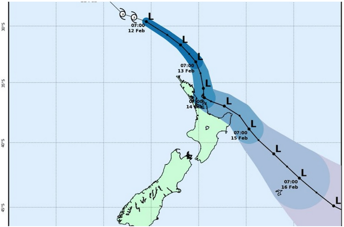
    Cyclone Gabrielle's predicted track 120223
    Cyclone Gabrielle’s predicted track as shown by MetService today. Image: MetService /RNZ

    This post was originally published on Asia Pacific Report.

  • RNZ news

    Coromandel Peninsula and Gisborne north of Tolaga Bay are now under red heavy rain warnings in Aotearoa New Zealand linked to Cyclone Gabrielle.

    MetService says it expects up to 400 mm of rain to fall in the regions, mostly on Monday.

    Civil Defence Controller for the Coromandel Garry Towler said that as well as heavy rain, winds of up to 130 km/h were expected and after weeks of severe weather, civil defence officials are very worried.

    Towler said the Coromandel was in a fragile state after the extreme weather battering late last month — which left four people dead — and Civil Defence was deploying as many resources onto the Coromandel as it could.

    He said a mobile alert would be issued this afternoon, and warnings would go out to people in vulnerable areas.

    The storm is due to track across Northland on Sunday before moving south to Auckland, Coromandel, Waikato, Bay of Plenty and Gisborne on Monday and Tuesday.

    Forecasters are warning of strong wind, heavy rain and big seas.

    Widespread severe weather
    MetService meteorologist Lewis Ferris said the cyclone would bring widespread severe weather.

    The cyclone had taken a more eastern track over the last few days, but there was still disagreement over where the central point will lie when it made landfall, Ferris said.

    “It’s still looking like Monday-Tuesday are going to be the biggest days for the weather with the approaching cyclone. The worst impacts, where they are and when they occur, are still going to be riding on where the track of the cyclone actually eventuates.”

    It is possible that even Wellington could see some impacts, MetService said.

    The cyclone has been upgraded to category 3.

    MetService has issued heavy rain and strong wind watches ahead of its arrival.

    Earlier today, MetService issued upgraded orange heavy rain and wind warnings associated with Cyclone Gabrielle.

    Orange warnings
    The orange warnings covered Northland, Auckland north of Whangaparaoa, including Great Barrier Island, Coromandel Peninsula, Gisborne and Hawke’s Bay.

    The rest of the North Island was under a strong wind watch, along with Marlborough, Nelson and Buller north of Seddonville in the South Island.

    There was also a heavy swell warning for Wairarapa.

    Meanwhile, the government is urging people to avoid non-essential travel in areas that could be hit by Cyclone Gabrielle.

    Air New Zealand is offering flight deferrals in affected areas, asking people to postpone air travel unless it was urgent.

    Emergency Management Minister Kieran McAnulty said safety trumped the disappointment of scrapping weekend plans.

    “We would urge people, despite the inconvenience this would naturally cause, to heed that advice, because it is not given lightly,” he said.

    “We are taking this very seriously. Depending on how this tracks it could be quite severe and we’re just asking people to take it seriously.”

    McAnulty said he had assurances government agencies and local civil defence services would update their social media channels regularly.

    People were also being urged to stock three days’ worth of food and water and prepare for possible power outages.

    This article is republished under a community partnership agreement with RNZ.

    • Latest advice from Civil Defence here.
    • Latest MetService warnings are here.

    This post was originally published on Asia Pacific Report.

  • ANALYSIS: By James Renwick, Te Herenga Waka — Victoria University of Wellington

    The extraordinary flood event Auckland experienced on the night of January 27, the eve of the city’s anniversary weekend, was caused by rainfall that was literally off the chart.

    Over 24 hours, 249mm of rain fell — well above the previous record of 161.8mm. A state of emergency was declared late in the evening.

    It has taken a terrible toll on Aucklanders, with four people reported dead. Damage to houses, cars, roads and infrastructure will run into many millions of dollars.

    Watching the images roll into social media on Friday evening, I thought to myself that I have seen these kinds of pictures before. But usually they’re from North America or Asia, or maybe Europe.

    However, this was New Zealand’s largest city, with a population of 1.7 million.

    Nowhere is safe from extreme weather these days.

    How it happened
    The torrential rain came from a storm in the north Tasman Sea linked to a source of moisture from the tropics. This is what meteorologists call an “atmospheric river”.

    The storm was quite slow-moving because it was cradled to the south by a huge anticyclone (a high) that stopped it moving quickly across the country.

    Embedded in the main band of rain, severe thunderstorms developed in the unstable air over the Auckland region. These delivered the heaviest rain falls, with MetService figures showing Auckland Airport received its average monthly rain for January in less than hour.

    The type of storm which brought the mayhem was not especially remarkable, however. Plenty of similar storms have passed through Auckland. But, as the climate continues to warm, the amount of water vapour in the air increases.

    I am confident climate change contributed significantly to the incredible volume of rain that fell so quickly in Auckland this time.

    Warmer air means more water
    There will be careful analysis of historical records and many simulations with climate models to nail down the return period of this flood (surely in the hundreds of years at least, in terms of our past climate).

    How much climate change contributed to the rainfall total will be part of those calculations. But it is obvious to me this event is exactly what we expect as a result of climate change.

    One degree of warming in the air translates, on average, to about 7 percent more water vapour in that air. The globe and New Zealand have experienced a bit over a degree of warming in the past century, and we have measured the increasing water vapour content.

    But when a storm comes along, it can translate to much more than a 7 percent increase in rainfall. Air “converges” (is drawn in) near the Earth’s surface into a storm system. So all that moister air is brought together, then “wrung out” to deliver the rain.

    A severe thunderstorm is the same thing on a smaller scale. Air is sucked in at ground level, lofted up and cooled quickly, losing much of its moisture in the process.

    While the atmosphere now holds 7 percent more water vapour, this convergence of air masses means the rain bursts can be 10 percent or even 20 percent heavier.

    Beyond the capacity of stormwater systems
    The National Institute of Water and Atmosphere (NIWA) estimates that over Auckland, one degree of warming translates to about a 20 percent increase in the one-hour rainfall, for a one-in-50-year event.

    The longer we continue to warm the climate, the heavier the storm rainfalls will get.

    Given what we have already seen, how do we adapt? Flooding happens when stormwater cannot drain away fast enough.

    So what we need are bigger drains, larger stormwater pipes and stormwater systems that can deal with such extremes.

    The country’s stormwater drain system was designed for the climate we used to have — 50 or more years ago. What we need is a stormwater system designed for the climate we have now, and the one we’ll have in 50 years from now.

    Another part of the response can be a “softening” of the urban environment. Tar-seal and concrete surfaces force water to stay at the surface, to pool and flow.

    If we can re-expose some of the streams that have been diverted into culverts, re-establish a few wetlands among the built areas, we can create a more spongy surface environment more naturally able to cope with heavy rainfall.

    These are the responses we need to be thinking about and taking action on now.

    We also need to stop burning fossil fuels and get global emissions of carbon dioxide and other greenhouse gases down as fast as we can. New Zealand has an emissions reduction plan — we need to see it having an effect from this year.

    And every country must follow suit.

    As I said at the start, no community is immune from these extremes and we must all work together.The Conversation

    Dr James Renwick, professor, Physical Geography (climate science), Te Herenga Waka — Victoria University of Wellington. This article is republished from The Conversation under a Creative Commons licence. Read the original article.

    This post was originally published on Asia Pacific Report.